Where's the fun and verve with waterfront access in DC?
Today's Post has a photo of people sunbathing yesterday at South Street Seaport in New York City. The photo at left isn't the photo but was taken by the same AP photographer, John Minchillo.
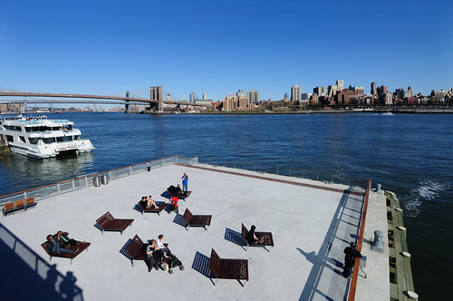
 A photo more like the one that ran in the Post is shown at right, taken by Flickr photographer Cocktail Tea. It's interesting because it shows how the South Street Seaport, to leverage its placemaking and location values, built a deck on the water where people can have fun.
New York has other examples of this kind of thinking, including planning to put a "pool" in the East River. See "Actual possibility: A filtered, floating pool in the East River" from TimeOut New York and "A Public Swimming Pool Floating In The East River" from Brooklyn365.
This is modeled after an existing example in Bronx, where a Floating Pool was installed by the Neptune Foundation, using a barge. According to Jonathan Kirschenfeld Architect PC, in the early 1900s, there were as many as 15 floating pools that had been built and placed in the East and Hudson Rivers.
New York City also employs construction dumpsters as temporary pools as part of Summer Streets and other initiatives. See "Dumpster Pools Making a Splash in Manhattan" from Tree Hugger.
And AT&T Park's (a baseball stadium) Waterfront Promenade in San Francisco is another example of providing playful and creative waterfront access. From the listing on Ballparks.com:
Waterfront Promenade: A unique public promenade has been developed along the waterfront from right field to center field where fans of all ages can watch the game through a fence at no charge and where San Franciscans can enjoy new access to the bay 365 days a year. Ferries dock directly adjacent to the ballpark beyond the right field wall.
On the other hand, DC's river front, both along the Anacostia and the Potomac River, doesn't have a whole lot of water-access that isn't passive park enjoyment, which makes "sense" given that the National Park Service controls most of the land. (Also see past blog entries "Explore the Anacostia River for fun and in terms of thinking about the connection of the city to the water" and "Wanted: A comprehensive plan for the "Anacostia River East" corridor.")
 This will change some with The Wharf development in Southwest DC. They will extend piers into the water, construct a promenade, and will have more public connections to the marina.
Image left from the PerkinsEastman website. The firm is the principal architect for the project.
DC has built two nice parks in the Capitol Riverfront District, Canal Park, which doesn't have river access, and Yards Park, which does have river frontage, but not a floating pool. DC also constructed a very attractive park, the Georgetown Waterfront Park, but again, no direct river-engaging activities.
Labels: ferries/water taxis, rivers and waterfronts, urban design/placemaking


5 Comments:
the DC government is again sufferring from sever lack of imagination- this whold waterfront was once a very active ocean going port area - and it should be reactivated to accept cruise ships and visiting naval ships as it did up into the late 70's or so when the silting below the surface got so bad. Of course this would entail dredging- which was done with the Alexandria part of the cannell during the Wilson bridge rebuilding project- DC just sits back and nobody cares about any of this at all. I have never seen a city that ignores it's once proud marine heritage so much as DC.
Sadly, it seems as if I am never gonna win the Powerball when it gets up to the $600 millions... if I did, I'd buy a steamboat or two and bring back steamboat service as a tourism and cultural heritage endeavor between Baltimore, Norfolk, and DC. Hopefully, it could break even...
DC once had numerous steamship lines- some of them brought people here to DC for shopping trips from the southern ports- a lot of people have no idea that DC was once a thriving port city- it simply does not fit into the "common" view of DC as white collar K street button down collar whatever...
I always look for images of this but haven't been very successful. I do have a couple pieces of ephemera of Wilson Line trips to Mount Vernon.
you can get the old pre- WW2 maps of DC and they clearly show the 5-6 different steamship lines operating out of the the 7th street warf area- which is now just a parking area for pleasure craft and no longer a working harbor for a real port city with far flung connections. Georgetown had quite a history, too,. I am reading a book " A Town Divided" recommended to me by a local DC author working on a history of DC restaurants [ John DeFe..]. It would be nice for someone to try to put together a really good picture book with a full history of the total DC waterfront- including the massive ocean going battle tubs that called into the navy yard right up until recent decades. So much has been lost and so many newcomers assume we have none of this history when that is the fartheset thing from reality...
Post a Comment
<< Home