Rebuilding Place in the Urban Space

"A community’s physical form, rather than its land uses, is its most intrinsic and enduring characteristic." [Katz, EPA] This blog focuses on place and placemaking and all that makes it work--historic preservation, urban design, transportation, asset-based community development, arts & cultural development, commercial district revitalization, tourism & destination development, and quality of life advocacy--along with doses of civic engagement and good governance watchdogging.

Tuesday, March 26, 2024

Francis Scott Key Bridge collapse in Baltimore: ferry/water taxi services as an option?

Photo: WJLA-TV

A tragedy this morning as the Francis Scott Key Bridge in Baltimore collapsed after being hit by a container ship. 

It's a key element of the roadway network--the bridge is part of Interstate 695, the freeway that rings the city but mostly in the suburbs, called the "Baltimore Beltway", carrying an estimated 12.4 million vehicles per year-- and its collapse means it blocks the Patapsco River entry into the Port of Baltimore ("Baltimore Francis Scott Key Bridge collapse: What we know about ship and bridge," BBC).

It's not like a freeway span in California or Philadelphia ("How commuters avoided ‘carmageddon’ after the I-95 bridge collapse Drivers," Washington Post) that can be replaced relatively quickly.  It will be down for a long time.  Although it's possible that many people can adjust.  According to the Post, in Philadelphia:

Drivers, helped by real-time traffic apps, public transit and more liberal work-from-home policies, quickly adjusted their habits to avoid gridlock

That won't help the Port...

The New York Times quoted a woman concerned about her ability to get to her job:

Marquita Finch, 38, was among a dozen or so people who climbed an embankment along a highway in Dundalk, just south of Baltimore, to see the collapsed bridge. The job she was supposed to be at this morning was just on the other side of the bridge. “I’m probably going to lose that job,” she said. A lot of people would probably lose their jobs, she said. 

I wonder if it's possible to institute a ferry/water service there in the interim, so people can cross more easily, so Marquita Finch won't lose her job.

Labels: , ,

Friday, December 30, 2022

Revisiting the need for comprehensive transportation planning at the metropolitan and regional scales | For profit services, and White's Ferry, Montgomery and Loudoun Counties

Chanting "two years too long," several hundred people showed up Thursday at the crossing in Poolesville to lend their voice to the cause of reopening White's Ferry. (Photo: WTOP / Kyle Cooper)

Not much to say.  

WTOP radio reports, "Hundreds rally in Poolesville to get White’s Ferry reopened," on a protest by people advocating for reopening the for profit White's Ferry crossing the Potomac River connecting Loudoun County Virginia to Poolesville in Upper Montgomery County, Maryland.  The ferry allows for the saving of a lot of time by users.

But it's a demonstration of a quirk in planning generally and transportation planning specifically.  Mostly, a master plan only covers what the government controls or operates, and usually ignores for profit services, and often, franchised services.

I mention the ideal model of transportation planning and operation being the German Transport Association, but even there, I don't think they include for profit services like car sharing and electric bicycle or scooter services.

-- "The answer is: Create a single multi-state/regional multi-modal transit planning, management, and operations authority association," 2017
-- "Verkehrsverbund: The evolution and spread of fully integrated regional public transport in Germany, Austria, and Switzerland," International Journal of Sustainable Transportation, 2018

When I first wrote about this issue ("Gaps in planning practice: privately owned White's Ferry on the Potomac River and county transportation planning") I mentioned how neither the Loudoun County nor Montgomery County transportation plans even mentioned the ferry service.

Later comments update the situation, and how Loudoun and Montgomery Counties did commission a report on what to do.

-- White's Ferry Operations Alternative Study

Again, if there were a true regional transportation association, this ought to have been addressed long before.

The point of planning is to be proactive, not reactive.

Labels: , , ,

Friday, January 21, 2022

Waterfronts/rivers/canals as districts needing special and ongoing "zoning" and environmental review

When I was briefly involved in the now scuttled Anacostia River Trust, I suggested that the group should advocate for a "Rivers and Waterfronts" element in the update to DC's Comprehensive Plan.  The Office of Planning wasn't favorable.  

Although a year later, they proposed a Waterfront Commission ("DC puts forward legislation to create Waterways Commission and Authority," ), something I'd been suggesting since 2006.  

I also suggested the organization should encourage Advisory Neighborhood Commissions in the communities abutting the Anacostia River to create a "River and Watershed Committee" to better address neighborhood environment issues arising from that proximity.

There are other efforts, like the Anacostia River and Potomac River Riverkeepers, the Alice Ferguson Foundation and its cleanup efforts, the Anacostia Watershed Society etc.  

And before that I advocated for more comprehensive planning initiatives along the river:

- "Wanted: A comprehensive plan for the "Anacostia River corridor"," 2012
-- "DC has a big "Garden Festival" opportunity in the Anacostia River," 2014
-- "A world class water/environmental education center at Poplar Point as another opportunity for Anacostia River programming (+ move the Anacostia Community Museum next door)," 2014
-- "The Anacostia River and considering the bridges as a unit and as a premier element of public art and civic architecture," 2014

Basically, cities see waterfronts as revitalization opportunities, as once industrial and constrained places in cities were abandoned, providing new opportunities for residential, retail, entertainment, etc.   Baltimore's Inner Harbor revitalization -- "Harborplace" -- became an example relevant to efforts world wide ("On the Revitalized Waterfront: Creative Milieu for Creative Tourism," Sustainability Journal, 2013, "Baltimore's Harborplace in bankruptcy and what that says about certain development trends in urban revitalization," 2019).

Some waterfront revitalization efforts I've come across over the years include:

Providence.  Reading a blog entry, "Save a Providence water view," in Architecture Here and Now, the writer, retired now from the Providence Journal, comments that planners and advocates could have done a better job in advocating for better projects along the waterfront.  From the article:

I feel sorry for people who have recently moved into the Benefit Street neighborhood. Perhaps they thought that this city, whose past is so clearly a model upon which to build its future, might adopt development policies that would protect and extend its built heritage. Not to mention residents with even longer tenure in the neighborhood. How could they imagine, after the excellent River Relocation Project of 1990-1996 that created a new, beautiful, traditional downtown waterfront, that the city would instead imitate most American cities, knuckling under to the profane demand, among “professionals,” for architecture that rejects the past and condemns us all to a purposely ugly future.

As the only architecture critic in Providence, and one of the few (if any) around the nation, who tries to follow and review vital projects through their stages of development from a classical design viewpoint, I share blame – for not nagging and blasting the city’s various design commissions (the so-called “experts”) with sufficiently harrowing curses.

I commented that cities like Baltimore and Cleveland (and in DC the federal interest is quality design is represented by the Committee of Fine Arts) have special urban design review processes for areas of special interest, usually downtown areas, and of course, historic preservation districts.

I guess it's in response to a competition to build a development on the waterfront ("'Massive and intrusive': Providence locals double down on waterfront apartment criticism," Providence Journal).  Oddly, the article is readable in my phone newsfeed but not on the computer.  Reading the article and others linked within demonstrate the importance of a waterfront "preservation and development" district calling for extranormal design review.  

Interestingly, because the parcel is part of the I-195 Redevelopment District Commission's purview, it's exempt from review by the city.  They say they will provide opportunity for review, but it isn't mandated.

Development proposal for the Providence, Rhode Island waterfront

As I say about this more generally, without remedies -- provisions within law calling for review processes -- you can't do s*** ("Without remedies there's nothing you can do: historic preservation in Chicago and DC," 2014, "To be successful, local neighborhood stabilization programs need a packaged set of robust remedies: Part 2," 2020).

River corridors and waterfronts need to be special planning review districts too.

Philadelphia.  There are a couple of recent articles relevant to this.  This one on Fishtown makes the point that developments are being approved that are in areas that will be affected by rising water levels resulting from climate change ("Climate change should be a consideration in planning massive Fishtown housing developments," Philadelphia Inquirer).  From the article:

But along Philadelphia’s riverfronts, buildings are going up in areas that we know are going to flood. More than 600 new apartments are coming to the Navy Yard. New buildings will be constructed on the former PES refinery site in South Philly. And on the Delaware River in Fishtown, development is also being pushed through. I’m not a NIMBY, but a NIMBIIR: Not In My Backyard If It’s Riverfront.

Last summer, Philadelphia’s director of the Office of Sustainability, Christine Knapp, acknowledged the problem with unregulated, “piecemeal” development along our riverfronts in a Philadelphia Neighborhood Networks Zoom: “We need to have standards across the board that any new developments, that any new investments are made with the right science in mind,” Knapp said.

She continued: “When we let people build on the riverfront, it makes it worse for everyone else. But the city is also taking on the problem of what happens when that property floods and the city has to rescue folks, or the city has to be responsible for the response to that storm or that flood. It’s like a triple-edged problem. We absolutely need to get ahead of it.”

Also see "Blighted luxury houses facing Fishtown’s Penn Treaty Park will be demolished. Now what?," "Philadelphia officials stopped Rivers Casino from closing off its Delaware River trail, but that’s not enough," and "Lower Merion suddenly has a walkable riverfront, thanks to Pencoyd Landing development," by the Inquirer's fabulous urban design writer, Inga Saffron.

An interesting and relevant program is being developed in Philadelphia ("William Penn Foundation is giving $1.65 million to create a new Delaware River Climate Corps," Philadelphia Inquirer).  Training programs for watershed stewards, like by the Anacostia Watershed Society, and Riverkeeper advocacy programs have similar elements.

Further, a number of the city's rivers are deemed "impaired."

Pennsylvania.  Another Inquirer article, "Nearly 2,400 more miles of Pennsylvania’s streams are impaired now compared to just two years ago; Philly has the highest percentage," makes me think that as part of a 21st Century New Deal, dealing with rivers and water quality should be a priority and could be a way to better connect Democrats to rural-relevant issues and voters.  Of 85,000 miles of rivers, 28,000 miles are impaired.

Especially because rivers are the primary water source for most communities, the impact of climate change especially drought, etc.

DC.  There's a Post op-ed, "Everyone should be able to swim in the Potomac."  And DCist reports that five spots on the Potomac and Anacostia Rivers and the Washington Channel are already clean enough to swim in ("Water Quality Data Show Where Swimming Beaches Could Be On D.C. Rivers").

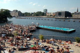
Badeschiff Pool with beach, Berlin. 

Again, when I did the ART stuff, I wrote a memo about how even though most of the Anacostia Riverfront in DC north of the 11th Street Bridge is controlled by the federal government, DC has the lease of the RFK Stadium and "campus" and there is a stretch of waterfront there that could be "converted to a beach" as a way to give people an opportunity to "touch" the river.  

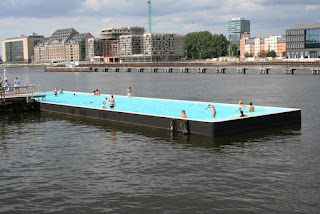
This would increase interest and the ability to mobilize citizens to change the dynamic within federal control ("Engaging citizens in DC's rivers and waterfronts as a way to drive improvements in water quality").  One of my ideas was to have a freshwater pool in the river.

Badeschiff, River Spree, Berlin.  Photos: Amusing Planet.

It's obvious that should have happened with the Potomac River a long time ago ("Pools in rivers to promote access and awareness," 2016).  

The funny thing is that outside of Georgetown, the east side of the river is pretty much all under the control of NPS.  And NPS rules make it very difficult to have local involvement and activation.

Worse, the Georgetown Waterfront Park, another NPS park, was created in part with land given to NPS by DC, because DC didn't want to take on the responsibility of having a park there.  What a lost opportunity.

Separately, wrt federal control, I argue that Anacostia Park should revert to DC because it is locally serving ("Defining National Park Service installations in DC as locally or nationally serving") and that maybe golf course isn't the best use for the Langston Golf Course ("DC, parks planning, and golf," "Golf, parks planning, and too many courses"). 

Maybe as part of improving access to Roosevelt Island ("Revisiting: Access to Theodore Roosevelt Island, a national park in Washington, DC") a pool could be created in the Potomac too.

Music barge/Cinema.  Another activation device is concerts on the river ("Music barge designed by Louis Kahn could anchor in Philadelphia as a concert stage," Philadelphia Inquirer).  We once took in the BargeMusic program in Brooklyn, although it's enclosed.

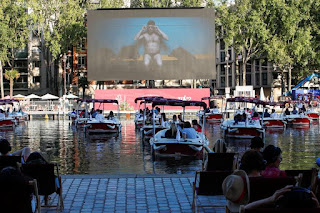
Reuters photo.

Paris screened movies to people on paddleboats ("Movie magic as Paris turns the Seine into open-air cinema," Reuters).  Chicago too.

Daylighting rivers and creeks.  Such review districts could include rivers and creeks that have been undergrounded ("Set the underground rivers free," Boston Globe).  From the article:

Exhuming waterways that run beneath developed areas and restoring their natural flow and width is known as “daylighting.” And in the Northeast, you don’t have to look far to find formerly lost rivers that have been brought back into the light. From Providence to New York to Boston’s Emerald Necklace, these forgotten waters are being surfaced to rejuvenate parks, revive local economies, and create bigger reservoirs that can prevent flooding during increasingly dangerous storms. ...

But for more than a century, putting streams in pipes or covering them with roads was a standard thing for cities to do. To create more paved ground for their expanding urban infrastructure, cities routed inconvenient waterways into culverts and conduits, overlaying the pipes with concrete. ...

It’s not just flora and fauna that can thrive when waterways are uncovered. During the 1990s, Providence daylit the Moshassuck and Woonasquatucket Rivers by removing highway and railroad infrastructure that had covered them for decades. This sparked the construction of Waterplace Park, a lagoon and a cobblestone riverwalk that became the hosting ground for the WaterFire festival led by the artist Barnaby Evans. Since its first river lighting in 1994, WaterFire has brought millions of visitors — and their wallets — to the city’s formerly depressed downtown. In 1997, the architect Friedrich St. Florian, who designed the Providence Place mall, called WaterFire “the crown jewel of the Providence renaissance.”

Daylighting success stories like Providence’s demonstrate why cities such as Detroit, Berkeley, Calif., and Yonkers, N.Y., have daylit lost rivers of their own. In the next few years, New York City will spend more than $130 million to excavate Tibbetts Brook, long buried beneath the Bronx.

Conclusion.  Definitely cities should create special interest design and environmental review districts for rivers, waterfronts, and canals.

Labels: , , , , , , , ,

Monday, April 26, 2021

Two train/regional transit ideas: Part 1 | Amtrak should acquire Greyhound

Building from my writings on railroad transportation primarily in the DC area, including the DC State Rail Planning process in 2015 and both built on and led to other pieces arguing for transformation:

-- "A regional railroad passenger transportation vision for DC, MD, VA, WV and parts of PA," 2006
-- "Regional transportation planning and fixed rail service," 2009
-- "Why don't Maryland and West Virginia think about expanding MARC into a true regional system?
-- "One big idea: Getting MARC and Metrorail to integrate fares, stations, and marketing systems, using London Overground as an example," 2015
--  "A new backbone for the regional transit system: merging the MARC Penn and VRE Fredericksburg Lines," 2017
-- "A brief comment on ground transportation at National Airport vis a vis VRE rail service," 2016
-- "A "Transformational Projects Action Plan" for a statewide passenger railroad program in Maryland," 2019
-- "The ability to develop around transit stations is conditional on land use and mobility context," 2012

along with learning about the privatization and organizational of railroad passenger services in Japan, I have a partially written series about re-articulating train service planning and operations at the national and multi-state scale.  

Amtrak expansion as part of the President Biden infrastructure program.  It's too bad it wasn't ready in advance of the recent promotion of expanded Amtrak service as part of the Biden infrastructure initiative ("At 50, Amtrak could get the transformational makeover it needs," Seattle Times).  

Joe Biden, then-presidential nominee, campaigns at the Amtrak station in Alliance, Ohio, on Sept. 30. Biden — our most famous Amtrak rider — is proposing an $80 billion infusion in railroads. 
(Gabriela Bhaskar / The New York Times,

From the Boston.com article "Here’s what Amtrak’s vision for 2035 looks like for New England":

Biden’s sweeping $2 trillion infrastructure plan calls for a total of $80 billion in new rail funding to address Amtrak’s repair backlog, modernize the Northeast Corridor, improve existing corridors, connect new cities, and enhance programs to support passenger and freight rail safety, efficiency, and electrification, according to the White House. 
With that funding, Amtrak — which is publicly funded and privately operated — said Wednesday that it would be able to execute on many of those goals, including improving Northeast Corridor trip times and expanding service to underserved communities across the nation. 
The proposal would be the first major expansion in the 50-year history of the agency, which was approaching profitability prior to the COVID-19 pandemic. Since its creation in 1971, Amtrak has barely seen any changes to its route map and has faced local opposition to expansion in some parts of the country, as The New York Times recently reported. However, Amtrak CEO Bill Flynn said Wednesday that Biden’s plan could finally set those plans in motion. 
“Amtrak has a bold vision to bring energy-efficient, world-class intercity rail service to up to 160 new communities across the nation, as we also invest in our fleet and stations across the U.S.,” Flynn said. “With this federal investment, Amtrak will create jobs and improve equity across cities, regions, and the entire country – and we are ready to deliver.”

JR/Japan Railway as a model

The privatization and reorganization of Japan Railway is my model.  Announced in the late 1980s, and implemented in phases in the 1990s, the company was broken up into 6 regionally-based companies, and a seventh company for Freight, with interconnected services across regions ("Lessons from Railway Privatization in Japan," Tokyo Review, "The Privatization of Japan Railways and Japan Post: Why, How, and Now," Asian Development Bank, "Privatization of JNR, 30 years on," Japan Times).  

As a government corporation, Japan National Railways was ponderous and losing money and the government didn't want to continue to fund massive debts.  Not all of the companies are privatized, because some aren't profitable.  Besides a much greater focus on the customer and marketing, a major change with privatization was allowing the companies to be active property developers and operators of related businesses, which provides as much as 33% to 60% of total revenues of firms like JR East and JR Kyushu.  City-centered railway companies are better positioned to take advantage of such opportunities, while more rural-oriented companies suffer from declining population, competition with the automobile, etc., and require ongoing subsidy.

The JR services are "trunk line," foundational services, and are complemented by a large number of what they call "third sector" rail passenger services, which are a mix of privately owned and operated and publicly-supported rail lines. (There is also inter city bus service, not affiliated with JR.)  The Shinkansen train services, the first high speed rail services in the world, compete with airlines and provide premium service.

While some of the non JR services are fairly large companies, most are quite small and very localized.  

All of the rail companies, JR and third sector, work heavily to market their services, create special tourist trains, and work with local communities on economic development and tourism promotion ventures.  

In fact, such promotion used to be quite common with US railroad companies in the 20th century, promoting tourism, business development, residential recruitment, etc.

Most US railway companies (and major gas station companies) had tourism departments.

Creating multi-state regional transit districts.  I propose creating six regional transit districts across the Continental United States, with national (cross district) and regional Amtrak services as the foundation, complemented by the creation and extension of railroad services within and across the states, further complemented by inter city bus services, but also water-based ferry transit where appropriate (e.g., in parts of New England, Washington State, California, Maryland, etc.).

My six regions for a national and regional railroad transportation plan*

This organization of the regional districts isn't "final."  A study of mobility flows between states should determine the distribution of states across the mobility districts.  For example, maybe Arizona and Nevada should be with the Coastal region, or Arizona and New Mexico with the Intermountain region, etc.  Or perhaps some states should participate in two regions, depending on the nature of their mobility flow.

Many of the ideas promoted by Amtrak as part of their 2035 initiative work well within that framework, which still extends beyond what Amtrak is approaching ("Amtrak unveils ‘Connects US’ map that suggests new corridors," Trains Magazine).


New Amtrak vision map for 2035

Map of what Amtrak expansion would look like in New England

New service denoted in light blue; enhanced service marked in yellow

Intra-state and multi-state railroad expansion initiatives should be integrated into this program, comparable to how Japan's "third sector" railroads either complement JR services or in some cases compete with them (e.g., Keikyū  has five lines totaling 87km, 73 stations, and over 1 million daily riders pre-pandemic).

Proposals for passenger rail expansion in Michigan not involving Amtrak.

For example, expanding MBTA beyond Greater Boston, even into New York State ("East-west Rail: Massachusetts Department of Transportation angers public after recommending further studies weeks before final report," WBUR/NPR), expanding Metro-North beyond Greater New York into other parts of New York State, my concept for a statewide passenger railroad program in Maryland, and various existing efforts like Amtrak Cascades, Amtrak California, Amtrak Virginia ("Virginia, Amtrak, CSX Advance $3.7B Rail Initiative," Railway Age), the Maine Downeaster, Brightline plans in Florida ("Brightline has summer deadline for agreement of route from Orlando to Tampa," WESH-TV) and California-Las Vegas ("Brightline CEO: Vegas-to-LA high-speed rail line still on track to break ground in 2021," Reno Gazette-Journal), etc.

Rebuilding a national rail/bus transit network: Merge Amtrak and Greyhound

Greyhound national bus route map

While the forthcoming series on the rearticulation of rail transport focuses on the train, the reality is that it is about transit planning and operation at a large multi-state and national scale.  

To work, it places rail at the foundation, complemented by inter-city bus and ferries, as appropriate, to create a wide and deep mobility network that is not car dependent.  

(Although a big focus within building the viability for rail is to replace short distance airplane travel with train trips, and to electrify to the extent possible the rail network, on climate change grounds.  Coastal states like Massachusetts, Connecticut, Maryland, etc., have a great opportunity to reduce greenhouse gas emissions through shifting to train passenger use and electrification.)

Inter city bus is a neglected area of transportation planning.  Because bus services are mostly privately operated, there isn't a lot of public transportation planning for that mode.  

The Chaddick Institute at DePaul University is rare in that it pays attention to and produces research and writing on the inter city bus system.

Colorado's "Bustang" program is probably the best if not only example of planning and delivering inter city bus service at the state scale, with a focus of linking rural areas to major cities ("CDOT happy with Bustang ridership during COVID," Daily Sentinel).

Greyhound's owner would like to sell.  The media reports that First Group, the UK transit operator that tried to make a go of it in the US through three divisions: school transportation; transit agency service operation; and Greyhound; has sold its bus and transit division and wants to sell Greyhound, but has no takers ("FirstGroup sells bulk of US transport business in $4bn deal," Guardian).

A Greyhound bus on H Street NE in Washington, DC, after leaving Union Station.  Photo: Bill Clark, CQ/Roll Call.

Greyhound's acquisition would be a great opportunity to integrate the inter-city transit network into a more seamless system. If Amtrak were truly visionary and about regional and national transit, not just railroad passenger service, it would make sense to merge the companies, with the aim of creating the kind of national transit system I envision (which used to exist anyway, through the combination of the various railroad passenger services and their interconnections, complemented by bus services from Greyhound and Trailways--national providers, and local and regional providers).

But unfortunately it's a stretch.  Note that this is a "Transformational Projects Action Plan" concept at a massive scale.  Sadly, I don't think either the federal government generally or Amtrak specifically have within them the ability to seize such an opportunity.  The federal government is not known for its innovativeness and entrepreneurship although there are plenty of examples when it has done just that.

Amtrak was set up to be a "maintainer" of rail service, basically as a way to offload the expense of passenger service from freight-focused railroads increasingly in financial trouble, with a mandate for managed decline, complicated by difficult budget issues and political maneuvering within Congress, not to mention lobbying by private transportation organizations, especially airlines, to keep it uncompetitive ("Amtrak 2035 Map: Hopes and Challenges," Railway Age).

Amtrak system, 1978.

Amtrak is already a nonprofit corporation, so its corporate form isn't the issue, as much as its crippled mandate, funding, and political and other forms of competition.

Labels: , , , , , ,

Monday, October 07, 2019

New York City Ferry subsidies: it's obvious it should be repriced upward as a premium service

The fact that the New York City Ferry service, the only transit service operated by the City of New York, is priced the same as a single fare on the subway or bus, but the cost to provide each ride is significantly higher, is getting renewed media coverage.

According to Politico New York, based on a study by the Citizens Budget Commission, NYC has the second highest subsidy for ferry trips, surpassed only by New Orleans ("Should New York City charge more to ride the ferry?" ), but that's because NYC's fare is many dollars lower than peer systems.

-- "How the NYC Ferry could work: Experts weigh in on how to improve the city’s ferries without scrapping them," City & State
-- "NYC Ferry mostly used by white, well-off New Yorkers, city data shows," New York Daily News

The obvious course of action is to charge more, recognizing it is a premium service. But this is one more issue that Mayor DeBlasio is obstinate about and so far he refuses to acknowledge the reasonability of charging more.

I wrote about this, but as part of another entry, in 2018:

New York City is expanding the ferry system ("NYC Ferry service is getting a major expansion," Time Out) which is the only element of the transit system controlled directly by the city.  They'll be adding two routes, and three new vessels each with a capacity of 350 passengers, compared to the 150-person capacity of each boat in the 17 boats in the current fleet.

Commuter Emily Mueller enjoys a drink at the ferry bar on her way home to north Brooklyn on the evening ferry. Village Voice Photo: David Williams.

Before the recent agreement by Mayor DeBlasio to fund a lower cost transit pass for low income residents, advocates criticized the transit focus on ferries as helping the well off, especially because under mayor DeBlasio, the ferry fare is equal to the subway fare,$2.75, making it heavily subsidized.

From the Village Voice article "Foamland security: ferry riders say DeBlasio's subsidies spare them subway trauma":
Ferry riders are, by and large, higher-income New Yorkers taking advantage of subsidized ferry rides to avoid subways and buses — not because it’s a faster commute, but because of the ferry’s creature comforts such as elbow room, concessions, alcohol, WiFi, and the fresh sea air.

“The time factor has nothing to do with it for me,” explained J. Scott Klossner, a 53-year-old freelancer currently working for the Today show who takes the Rockaway route, even though it adds almost 45 minutes each way to his commute.

“I can get a coffee, a bagel, everyone is nice. The opposite is true of the A train: Everyone is a fucking asshole.”
London as a counter example: pricing ferry commuter rides as a premium service.  On my walking tour of London with former TfL official Ivan Bennett, we talked about the ferry services there, called the River Bus.

In planning for river  transit, TfL differentiates between commuter transportation and tourist services.

-- TfL River services
-- London River Services map and guide, Tfl (speaking of branding, it uses the same design style as other London transit services)
-- London River Services map, 2018

Ferry trips on the Thames tend to be slower than rail, but nicer, with coffee service and newspapers. Ivan argues that they should be marketed and priced as premium services, with the extra revenues used to support other aspects of the transit system.

And in London, they are.

(By contrast, most ferry fares in other places fares are higher too, but the services aren't necessarily marketed as premium.  But there is a recognition that water transit costs more to provide, but it's worth paying more because it may be the only option because there aren't bridges to the mainland, or it is less congested compared to bridges, etc.)

That seems like a sensible approach for pricing ferry/water taxi service in London and elsewhere.

While the individual fare for ferry service in London is higher than riding the Underground--2x to 4x higher than a single fare, they've slacked off raising River Bus fares, and because of the Crossrail cash crunch, expansions to the system have been delayed.

Past writings on water-based transit include:

-- "Metrorail shutdown south of AlexandriaNational Airport would have been a good opportunity to promote ferry service," 2019
-- "Instead of a third Chesapeake Bay Bridge, why not start out with a fast ferry from Rock Hall to Baltimore?," 2018
-- "Implementing transit services (water taxi) before the market will support them," 2017

Changing minds: Ken Livingstone, former Mayor of London versus most politicians, including Bill DeBlasio. In talking with Ivan about London's use of articulated buses instead of double deck buses, I wondered why they wanted to use articulateds, because double deck buses are so signature to London's identity. He said it was because there is only one entry door on a double deck buses, and to reduce bus dwell time, they wanted multi-door entry and exit.

Livingstone wasn't favorable, but as Ivan said "He listened [taking in what people said and then actually considering it}" and he changed his mind, based on the recommendations of the transit planners.

(In the vein of successors countermanding the decisions of predecessors, Boris Johnson made the decision to remove articulated buses from the London bus fleet.)

Many politicians don't listen, let alone consider what's been said and change their minds.

Labels: , , , , , ,

Thursday, May 30, 2019

Metrorail shutdown south of AlexandriaNational Airport would have been a good opportunity to promote ferry service

While I think ferry and water taxi services are cool, they don't lend themselves well to the DC area transportation system--apart from tourist oriented services--because the rivers aren't well-located vis-à-vis the area's office districts and major destinations.

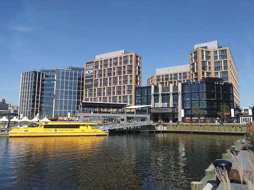
Water taxi at the transit pier at the Wharf District, Southwest DC

Water taxi at the transit pier at the Wharf District, Southwest DC

Potomac Riverboat offers tourist services between Alexandria, National Harbor, the Wharf, Navy Yard, Georgetown, and Mount Vernon, but the dis/embarkation points aren't convenient to transit connections, and people would still have a long trek to get from the Wharf or Navy Yard to Downtown after getting off a ferry (although like in NYC, the ferry could provide a connecting bus service).

They do offer a reasonably priced season's pass between certain destinations, to encourage transit use--it's $175 versus $20 for a single trip.

(Past discussions of ferry service in the area have discussed Joint Base Anacostia-Bolling in DC as a possible place for a dock.  Boston provides a dock for Logan Airport, so National Airport could be a place to serve.  And Rosslyn, since it is an office district, and the business district is a trek from Washington Harbor in Georgetown, where the dock is now.)

Position water-based transportation as a premium service.  When I was in London last year, I spent almost a full day with Ivan Bennett, former product design manager for the bus division of Transport for London, and that included about a six hour walking tour along the Thames.

He pointed out that the River Bus ferry system there is positioned as a premium service, triple the cost of a ride on the Underground, somewhat more comparable in price to commuter rail.

It takes a bit longer than a subway ride, but it's fun, comfortable, sedate, you can get/read newspapers, etc.

New York City needs to follow London's lead and reprice and reposition their new ferry services as a premium service.
The Staten Island Ferry is free, justified because Staten Island lacks a subway connection to the mainland.

But the ferries on the rivers are priced the same as a subway fare, and each trip is subsidized by almost $25 !!!!! ("
A Ferry Subsidy of $24.75 a Ride? New York City's Costs Are Ballooning," New York Times).

Metrorail shutdown.  For the next 13+ weeks, Metrorail service on Virginia's Blue and Yellow lines starts/ends at National Airport, as the stations south of this point--Braddock Road, King Street, Eisenhower Avenue, Huntington, Van Dorn Street, Franconia-Springfield--are closed for repair ("As Metro shutdown arrives, dread pervades the Yellow and Blue lines," Washington Post).

Bus shuttle service will be provided ("WTOP Track Work Guide: Summer 2019 Blue and Yellow Line shutdown," WTOP-radio). But there aren't many other options.

The VRE/Virginia Railway Express commuter service doesn't provide bi-directional service with one exception, and they don't have the ability to add trains. Probably commuter buses could be added, but there isn't really a coordinated system of commuter bus service from this area of Virginia, although buses would be available, if a service could be organized.

What about water-based transit? It didn't occur to me that this would be a great opportunity to promote water transportation.  Fortunately, it did occur to Fritz Hahn, the Washington Post nightlife columnist, who mentioned last Friday in a piece that this could have been done in association with the shutdown of the Metrorail.

Yes, there are a few problems with this idea.

1.  Lack of slack resources.  There aren't many ferries lying around ready and waiting to be used.  Usually they are ordered on long time lines, unused ones need fixing, etc.

2.  Short period.  A 10 week gig wouldn't be long enough to justify hiring a few ferries to try it out.

Unless stakeholders and planners would see this as worth doing for "market development" and proof of concept purposes.
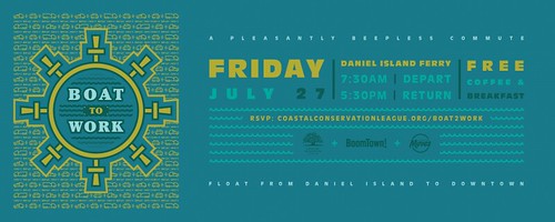
Boat to Work Day, Daniel Island, Charleston, South Carolina

Note that "Boat to Work Day" in Charleston, SC is a model for beginning to promote water-based transit in the DC area ("Boat to Work Day in Charleston, SC: is a promotion that other water-based transportation services ought to adopt").

3.  Unbalanced service.  Probably the usage pattern would be unbalanced.  Lots of people going to DC in the morning, and from DC in the evening.  But return trips in between wouldn't have many passengers.

This isn't the case with ferry service in the Puget Sound, such as to Bainbridge Island.  The seven mile trip each way tends to be pretty full at all times of day.

4.  Capacity, draft, and dock access.  Anyway, water taxis are small and have small passenger capacity compared to subway trains.

Wikipedia photo.

For example, the small ferries in NYC have a capacity of 150-350.  King County's water taxis have a capacity of 278 passengers.

Big ferries, like for the Staten Island Ferry, have a capacity of 1,280 to 6,000 passengers depending on the ship.

The ferries serving Bainbridge Island have capacities of 2,500 passengers and 202 vehicles.

Ferries integrated into metropolitan and regional transportation systems often are integrated into the area's transit fare media system like Orca in Seattle, Clipper in SF, etc.  Photo: Carlos Avila Gonzalez / The Chronicle. Craig McKinlay and son Cullan, 7, get tickets for the ferry to Larkspur.

The ability for "large ferries" like those used for Staten Island, Puget Sound, or the San Francisco Bay ("Even the SF Bay ferries are crowded these days," San Francisco Chronicle) to dock close to the shore on the Potomac River is probably limited because of the depth of the water and the "draft" of the boat.

So a larger fleet of smaller ferries would be needed.

Labels: , , , , , , ,

Wednesday, January 30, 2019

Boat to Work Day in Charleston, SC: is a promotion that other water-based transportation services ought to adopt

It's pretty cold these days, which makes it tough to think about ferry and water taxi commuting, even though that's something that persists even in cold weather in New York City, Boston, San Francisco, and Seattle.
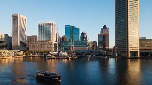
Baltimore Water Taxi, Inner Harbor skyline

Some water taxi services operating in cities, but mostly focused on the tourist market, do provide special pricing for commuter use.

-- "SA River Commuter Service Draws Excitement, But Few Riders So Far," Rivard Report
-- Chicago Water Taxi commuter webpage
-- "Water taxi's free rides are part of broader strategy to boost local ridership," Baltimore Business Journal

From the BBJ article:
While the boats are popular with tourists, the company wants to boost ridership among residents commuting to and from work, exploring the city on weekends or heading to happy hour, said Stacy Steinberg, Baltimore Water Taxi's director of sales and marketing. Some 150,000 people used the water taxi in 2017, though a breakdown of how many of these riders were tourists and how many were Baltimoreans wasn't available.

"We feel that locals can very much benefit from our service to get to various areas on the water and be able to get out and explore," Steinberg said. "We want to get the word out while letting people get a ride."

To highlight some of those opportunities, the water taxi is offering free rides to Marylanders Thursday to and from a selection of its 18 stops. To ride for free, you'll have to show a Maryland ID or another proof of residency. ...

Membership options rolled out last month include a 10-pack of one-way ride tickets for $40, a $90 summer pass offering unlimited rides through the end of September and an annual membership for $250. Individual water taxi day passes cost $16, with discounts for children, seniors and members of the military.
Charleston, DC's Boat to Work Day.  I came across an article in the Charleston Post & Courier mentioning how a pier expansion project in Mount Pleasant failed to ask for specific federal approvals for the potential for transportation purposes, and so such won't be included at least initially.

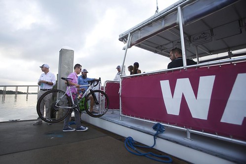
One of the photos illustrating the article called attention to a "Boat to Work Day" promotion for the Daniel Island Ferry in Charleston Harbor.
Water taxi in Charleston, South Carolina, Boat to Work Day, with a bicycle commuter
A bicycle commuter boards a water taxi on Daniel Island on Friday, July 27, 2018. The ride was part of Boat to Work Day. A Corps of Engineers permit for Mount Pleasant's Waterfront Memorial Park expansion prohibits commercial uses, including water taxis. Lauren Petracca/Charleston Post & Courier.

The Daniel Island Ferry doesn't offer regular commuting-focused service yet, although they intend to do so later in 2019.

The Boat to Work Day promotion, which included accommodation for bikes, was a special promotion involving conservation and sustainable mobility organizations including the Coastal Conservation League, Charleston Moves (what looks to be a nifty sustainable mobility advocacy group), and Gotcha Bike (bike share), along with a real estate development firm as sponsor, BoomTown.

I think more organizations looking to expand water-based commuting services ought to look creating similar promotions.
Boat to Work Day, Daniel Island, Charleston, South Carolina

==========================
Past writing on water-based transit:
For more detailed discussion including opportunities in DC and Baltimore see:

-- "Instead of a third Chesapeake Bay Bridge, why not start out with a fast ferry from Rock Hall to Baltimore?," 2018
-- "Implementing transit services (water taxi) before the market will support them," 2017

From a round up entry from 2018:

New York City is expanding the ferry system ("NYC Ferry service is getting a major expansion," Time Out) which is the only element of the transit system controlled directly by the city.  They'll be adding two routes, and three new vessels each with a capacity of 350 passengers, compared to the 150-person capacity of each boat in the 17 boats in the current fleet.

Commuter Emily Mueller enjoys a drink at the ferry bar on her way home to north Brooklyn on the evening ferry. Village Voice Photo: David Williams.

Before the recent agreement by Mayor DeBlasio to fund a lower cost transit pass for low income residents, advocates criticized the transit focus on ferries as helping the well off, especially because under mayor DeBlasio, the ferry fare is equal to the subway fare,$2.75, making it heavily subsidized.

From the Village Voice article "Foamland security: ferry riders say DeBlasio's subsidies spare them subway trauma":
Ferry riders are, by and large, higher-income New Yorkers taking advantage of subsidized ferry rides to avoid subways and buses — not because it’s a faster commute, but because of the ferry’s creature comforts such as elbow room, concessions, alcohol, WiFi, and the fresh sea air.

“The time factor has nothing to do with it for me,” explained J. Scott Klossner, a 53-year-old freelancer currently working for the Today show who takes the Rockaway route, even though it adds almost 45 minutes each way to his commute.

“I can get a coffee, a bagel, everyone is nice. The opposite is true of the A train: Everyone is a fucking asshole.”
London as a counter example: pricing ferry commuter rides as a premium service.  On my walking tour of London with former TfL official Ivan Bennett, we talked about the ferry services there, called the River Bus. In planning for river  transit, TfL differentiates between commuter transportation and tourist services.

-- TfL River services
-- London River Services map and guide, Tfl (speaking of branding, it uses the same design style as other London transit services)
-- London River Services map, 2018

Ferry trips on the Thames tend to be slower than rail, but nicer, with coffee service and newspapers. He argues that they should be marketed and priced as premium services, with the extra revenues used to support other aspects of the transit system.

(By contrast, some of the NYC Ferry routes can be faster than rail, because they provide service in areas underserved by the subway.)

That seems like a sensible approach for pricing ferry/water taxi service in London and elsewhere.

While the individual fare is higher than riding the Underground--2x to 4x higher than a single fare, they've slacked off raising River Bus fares, and because of the Crossrail cash crunch, expansions to the system have been delayed.

Labels: , , , , , ,

Friday, July 06, 2018

New York City sustainable mobility news

1. Toronto Transit Commission's Andy Byford was brought in to run the New York City Subway system and "fix it." The city often gets blamed for the problems, but the system is run by the state, with some funding from the city. Still, because it is so essential to the success of the city, it ought to be a higher agenda item for the mayor.

-- "Can Andy Byford Save the Subways?," New Yorker Magazine
-- "New subway chief Andy Byford still hasn't met with Bill de Blasio," New York Post

In this June 1, 2018 photo, an Enterprise CarShare vehicle occupies a parking space in one of the new designated Carshare areas, on New York's Upper West Side. New Yorkers are at odds over a new program that's taking away hundreds of public spaces and doling them out to companies that rent out cars by the hour. (AP Photo/Richard Drew)


2.  According to the Associated Press ("Road rage: NYC turns parking spots into car share-only zones"), NYC has instituted dedicated street parking for car sharing services.  The article discusses resentment on the part of car owners. From the article:
The two-year pilot program is pitting proponents of car sharing, who see it as an efficient alternative to car ownership, against car owners, who fear fewer spaces will force them to circle the block even more.

"Parking is not an easy thing to find. Period," said Jerry Armer, whose Cobble Hill, Brooklyn, neighborhood has seen 18 on-street spaces gobbled up for car sharing.

In his neighborhood, at certain times of the day, it isn't unusual to have to circle for 30 minutes for an open spot, only to wind up a half-mile (0.8 kilometers) from home. New Yorkers also deal with the scourge of alternate-side-of-the-street parking, which involves having to move your car once or twice a week to make way for street cleaners.

The pilot program has elicited some grumbles over the price these for-profit companies are paying for exclusive use of these hard-to-get spots: almost nothing.

Zipcar and Enterprise are each paying a one-time $765 fee for the curbside spots and $1,000 to $1,200 per year for each space in the city-owned lots. Residents of city-owned public housing also will receive discounts on car sharing services.
It doesn't mention that NYC residents don't have to pay for residential parking permits.  Nor does it mention a previous AP article about how Hoboken uses car sharing as a way to manage parking supply ("Car sharing program finds home in crowded Hoboken," 2012).

But it does mention that car share vehicles tend to support 10+ households without cars.

3. Central Park goes car free.  "Last automobile drives out of Central Park as park goes car-free," New York Daily News, although the transverse roads that connect west to east remain open to cars.

4. For many months I've been meaning to mention that Prospect Park in Brooklyn, another Olmsted park, went car free in January ("Prospect Park is car free at last," Village Voice).  The discusses the long period of evolution, not unlike what happened in Central Park, of both accommodating the car and then "nibbling back" on car access, first on Sundays, then including Saturdays, and then off-peak hours during the week, until the final decision to go car free on the Prospect Loop was made last fall, effective January 2nd ("Prospect Park to permanently go car free," New York Post).

(The VV article linked to an article addressing privatization of public space, "The death of the Olmstedian vision of public space," Journal of Leisure Research, (2000), which is relevant given the bulk of writings on successful urban parks tout privatization.)

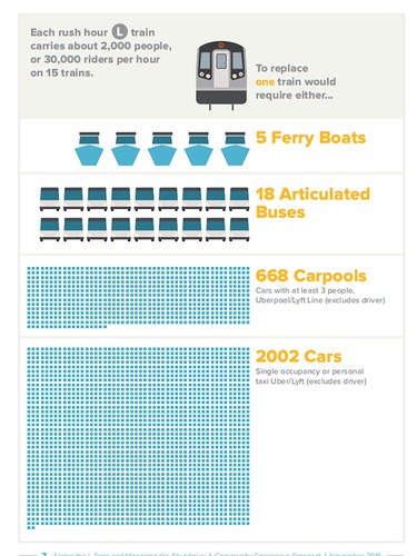
Capacity of different transit modes
5.  In response to criticism, New York City DOT is upping their response to the April 2019 closure of the L subway line for repair.  Earlier plans provided for bus lanes on 14th Street in Manhattan, but not making the road an exclusive transitway.  They've changed their tune.  From the New York Daily News story, "Ferries, 80 buses per hour to help accommodate commuters during L train shutdown":
The move to make 14th St. a mostly bus-only street for 17 hours a day marks a big shift from a city plan that would have restricted traffic only during the morning and evening rush.
Although I think it was imperative to also use higher capacity buses, even bi-articulated buses ("Revisiting stories: the L Subway Shutdown in NYC and what to do"), but they are not doing that. From the article:
Buses will play a significant role, too, in shuttling riders across the East River.

"80 buses per hour, accommodating 4,200 riders," Byford said. "80 buses per hour will form an intense bus shuttle across the Williamsburg Bridge."
Articulated buses could increase that capacity by up to 50% and bi-articulated buses even more.
The MTA says its new ferries will also help, carrying up to 1,190 riders on eight boats per hour.
6. I still don't think a streetcar makes sense for NYC, ("Will a BQX light rail along the waterfront in Brooklyn and Queens have extra-normal economic impact?") although Paris and London do use trams as part of their system.  (The Docklands Light Rail system in London runs on dedicated tracks.)

According to the Village Voice ("So Is the BQX Dead Yet or What?," Mayor DeBlasio hopes President Trump could come up with the money.  I wouldn't hold my breath.

-- "Tech sector needs BQX to reach potential in Brooklyn and Queens," Crain's New York Business

7. Mayor DeBlasio agreed to fund a lower cost transit pass for low income residents. ("New York City's $89 Billion Budget Includes Discount Transit Fare Plan," NYT). From the article:
Mr. Johnson had pushed hard to get the mayor to agree to include funding for subsidized MetroCards, an initiative known as “Fair Fares.” The program will begin in January, with New Yorkers whose income is below the federal poverty line — about $25,000 a year for a family of four — qualifying for MetroCards at half the regular cost. It is estimated that about 800,000 people could be eligible for the subsidy, although far fewer are expected to enroll in the first year.
9. New York City is expanding the ferry system ("NYC Ferry service is getting a major expansion," Time Out) which is the only element of the transit system controlled directly by the city.  They'll be adding two routes, and three new vessels each with a capacity of 350 passengers, compared to the 150-person capacity of each boat in the 17 boats in the current fleet.

Commuter Emily Mueller enjoys a drink at the ferry bar on her way home to north Brooklyn on the evening ferry. Village Voice Photo: David Williams.

Before the recent agreement by Mayor DeBlasio to fund a lower cost transit pass for low income residents, advocates criticized the transit focus on ferries as helping the well off, especially because under mayor DeBlasio, the ferry fare is equal to the subway fare,$2.75, making it heavily subsidized.

From the Village Voice article "Foamland security: ferry riders say DeBlasio's subsidies spare them subway trauma":
Ferry riders are, by and large, higher-income New Yorkers taking advantage of subsidized ferry rides to avoid subways and buses — not because it’s a faster commute, but because of the ferry’s creature comforts such as elbow room, concessions, alcohol, WiFi, and the fresh sea air.

“The time factor has nothing to do with it for me,” explained J. Scott Klossner, a 53-year-old freelancer currently working for the Today show who takes the Rockaway route, even though it adds almost 45 minutes each way to his commute.

“I can get a coffee, a bagel, everyone is nice. The opposite is true of the A train: Everyone is a fucking asshole.”
London as a counter example: pricing ferry commuter rides as a premium service.  On my walking tour of London with former TfL official Ivan Bennett, we talked about the ferry services there, called the River Bus. In planning for river  transit, TfL differentiates between commuter transportation and tourist services.

-- TfL River services
-- London River Services map and guide, Tfl (speaking of branding, it uses the same design style as other London transit services)
-- London River Services map, 2018

Ferry trips on the Thames tend to be slower than rail, but nicer, with coffee service and newspapers. He argues that they should be marketed and priced as premium services, with the extra revenues used to support other aspects of the transit system.

(By contrast, some of the NYC Ferry routes can be faster than rail, because they provide service in areas underserved by the subway.)

That seems like a sensible approach for pricing ferry/water taxi service in London and elsewhere.

While the individual fare is higher than riding the Underground--2x to 4x higher than a single fare, they've slacked off raising River Bus fares, and because of the Crossrail cash crunch, expansions to the system have been delayed.

Labels: , , , , ,

Wednesday, March 21, 2018

Instead of a third Chesapeake Bay Bridge, why not start out with a fast ferry from Rock Hall to Baltimore?

Image from "Letter to Editor: Northern Bay Bridge Through Kent County Is Not a Viable Solution," Chestertown Spy.

In response to the article a couple days ago in the Washington Post, "Hope and opposition emerge as Maryland scouts locations for a new Chesapeake Bay Bridge," discussing the possibility of a third Bay Bridge, which could cost $7 billion or more, this suggestion came up in a private email thread.   The commenter chooses to remain anonymous.

Note that the Wilmington News-Journal and Baltimore Sun have been covering this issue for awhile.
========

Ferries in Washington (and Baltimore).  Before the development of integrated freeway networks, steamboats provided transportation within the Chesapeake Bay between Baltimore, Norfolk, and DC and within the Mid-Atlantic.

I've lived in the DC area since 1987 and I can remember back to at least 1992 proposals for ferries on the Potomac River, paralleling the I-95 corridor. 

The studies keep coming ("Fast ferry service in D.C. region possible in near future" and "Regional fast ferry concept moves forward," WTOP radio).

The problem with the concept is while the river seems so attractive a route, the problem is getting to it.  The distances to get from a rider's origin point to a river side pier and at the destination, from a river side embarkation point to the final destination, are considerable. 

Not to mention where you can have docks south of Alexandria may or may not be good places to capture enough potential riders.  Thus ferries don't seem all that practical a commuter mode in the DC area.

DC area water taxis.  That being said there have been various water taxi type programs between Alexandria, National Harbor (in Prince George's County), and the Southwest Waterfront.

Water taxi at the transit pier at the Wharf District, Southwest DCThe opening of the Wharf District ("District Wharf embraces DC’s waterfront," Charleston Gazette-Mail) is associated with a big expansion of water taxi services ("The Wharf water taxi service to National Harbor starts," WTOP radio), although I am still doubtful there is much in the way of commuter transportation potential for the service.

It can be successful as a tourist-focused service, comparable to the water taxis in Baltimore. From the WTOP article:
Potomac Riverboat Company, acquired by Chicago-based Entertainment Cruises in 2016, operates four water taxis from The Wharf, each with a capacity of 150 passengers. Water taxi rates start from $20 round trip, with season passes priced at $175 aimed more at commuters than recreational passengers.

The first departure from The Wharf to National Harbor is 7:15 a.m., and the first departure from National Harbor to The Wharf is at 8:15 a.m.
The one-way trip takes about 35 minutes.

The last boat departs from The Wharf to National Harbor at 10:50 p.m., and the last boat from National Harbor to The Wharf departs at 11:40 p.m.
The new Baltimore water taxi on the water. (Photo by Stephen Babcock).

Baltimore already has an extensive, tourist oriented water taxi system.   An investment group owned by Kevin Planch of Under Armour owns the Baltimore Water Taxi service ("Baltimore Water Taxi hopes to hire 25 amid expansion," Baltimore Sun); "More details on the new Water Taxi stops under Kevin Plank's ownership," Baltimore Business Journal) which focuses on serving the tourist market between the Inner Harbor, Fells Point, and Fort McHenry.

Ferries a viable transportation service in port cities.  Port cities like Boston, New York, San Francisco ("Bay Area ferry ridership exploding, especially in Vallejo; East Bay Times; "SF Bay ferry service on brink of major expansion," San Francisco Chronicle), and Seattle/Puget Sound ("A Seattle-to-Renton ferry? Regional leaders explore watery ways to ease traffic," Seattle Times; "Tacoma Councilmember Proposes a Fast-Ferry Service to Seattle," The Stranger) still maintain significant ferry operations, because of access constraints such as bridges as well as relatively short distances between the edge of the waterfront and central business districts and/or major destinations (such as Logan Airport in Boston).

New York City has been expanding ferries, but in part it's political, because it's the only mode under the direct control of the city ("New York City's Ferry Fleet Is Off to a Fast Start" and "How the Ferry Is Changing the Brooklyn-Queens Waterfront," New York Times). Services continue to expand in the Puget Sound region also.

Instead of a bridge, why not start with a fast ferry from Baltimore? Modern ferries are a lot faster than the ones that were taken out of service seventy years ago.

-- Damen Shipyards Public Transportation Brochure

They could do a fast ferry from Rock Hall to Baltimore Harbor, with a free covered bicycle park and ride, and a paid auto park and ride. It would be a viable commute. .

A passenger ferry large enough to carry bikes would attract some bike commuters who live and work within biking distance of the ferry terminals. Bikes are free on the Cape May ferry. It would also promote tourism, for both Kent County and Baltimore. Anyone who gets off the ferry with a bike is probably planning to spend locally, not ride all the way to Ocean City.

A passenger ferry, with a pricing structure that encouraged walking or riding a bike to the ferry, would not flood Kent County with automobiles. It would be more palatable than a bridge to people who oppose the traffic that a bridge would bring.

It would also be advantageous speed-wise, as it would be direct, rather than crossing the bridge and driving between Annapolis and Baltimore.

Proposed Port Covington development, Baltimore.

Rock Hall ("Weekend adventure: A visitor's guide to Rock Hall and its old-school, waterfront charms," Baltimore Sun) is currently a 91 mile drive from Baltimore Inner Harbor.

A ferry trip would be a little over 20 miles each way. The ferry trip would likely be much faster at rush hour. You could probably get Sagamore Development ("The Port Covington Redevelopment Project Examined," Baltimore Sun) to subsidize it--the same company owns the Baltimore Water Taxi.
The Rock Hall waterfront.

A second bridge would cost about $7 billion.

Test car ferries too. A car ferry should be studied separately. A large car ferry would affect traffic volumes on both ends, which would limit the number of viable landing locations. You couldn't use the same pier as the Water Taxi. It would likely have to be more costly for drivers than the Bay Bridge, which would limit its usefulness outside rush hour. Note that a round trip fare between Bainbridge Island and Seattle with a car is about $24/round trip.

Is the market for travelers large enough to support two bridges?

Paying for a new bridge with tolls is a stretch, especially with a Governor who likes to keep the tolls low ("Maryland cuts tolls on Bay Bridge, ICC and other roadways," Washington Post).

Fast ferries.  Kitsap County, Washington has introduced fast ferry service between Bremerton and Seattle.  Covering a distance of about 30 miles, the trips take about one half hour and cost about $12 round trip, with discounted commuter passes available. 

Although the program had a bunch of problems in the beginning including malfunctions and still wrestles with a poorly working reservation system ("Kitsap Transit fast ferry continues to maneuver through rough waters," Kitsap Sun), there appears to be growing demand for the service and it is stabilizing in terms of successful operations, with plans to add more vessels to meet demand and expansion.  The system is funded in part by a county sales tax.

The NYC Ferry shuttle bus. (DNAinfo/Katie Honan).

Complementary changes to surface transit in Baltimore would be required.  The "problem" with service between Baltimore and the Eastern Shore is people traveling from the pier in Baltimore to and from their final destination.  Seattle has a concentrated business district that is walkable from the ferry terminal. 

Although other ferry services to Seattle, depending on the route, include car ferries, whereas in San Francisco, the Ferry Terminal is served by multiple streetcar and bus routes.

A British bus route is marketed as the Crossriver Express.  A complementary bus program in Baltimore could be labeled as the Crossbay Express.

Better surface transit bus services would have to be developed to be able to make such a service work.  For example the private sector New York Waterways ferry service and the public sector NYC Ferry both provide complementary shuttle bus routes to get people closer to their final destination. 

A fast ferry service could co-develop necessary additions in conjunction with the Baltimore Circulator service.

Conclusion.  Perhaps Baltimore to the Eastern Shore, not the Potomac River, is the most viable place to test regular ferry service in the DC-Baltimore region.

Past blog entries on this topic include:

-- "Implementing transit services (water taxi) before the market will support them," 2016
-- "Water taxis/ferries in the DC region," 2011


Labels: , , ,