Where the subway lines go makes a difference in terms of subsequent development (if paired with land use changes)
There is a great post at GGW, "In 1968, this brochure is how people learned about Metro," showing photo images (not scans, unfortunately) of a late 1960s brochure put out by WMATA to explain what Metrorail would be, where it would go, and what it would look like--the first leg of the system did not open until 1976.
According to one of the commenters, the brochure was distributed at an event on the White House grounds, where a mock up of the subway car was shown.
The comment thread discusses the proposed routing of the lines versus the actual routing. One comment is about the northern routing of the green line in DC, which originally intended to go straight up Georgia Avenue in plans, before turning east at New Hampshire Avenue towards Prince George's County.
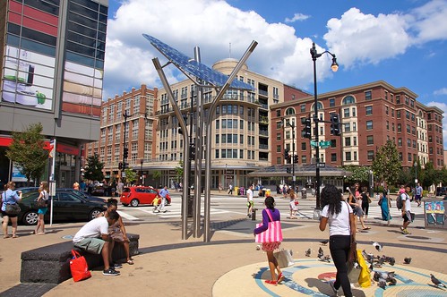 Flickr photo of Columbia Heights by Otavio.
Instead the routing of that line was changed, in favor of stations on U Street NW and in Columbia Heights on 14th Street NW, as an economic development move, as these areas had suffered greatly as a result of the 1968 riots, which wrecked most of the city's "historic commercial corridors" (14th Street NW, U Street NW, H Street NE, 7th Street NW, 9th Street NW) that lay outside of the central business district.
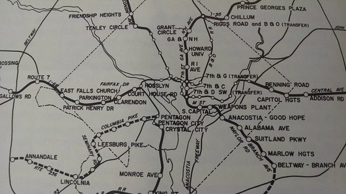
This map shows the originally proposed routing.
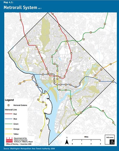
This is the actual routing (Source: DC Comprehensive Plan, 2006, Transportation Element)
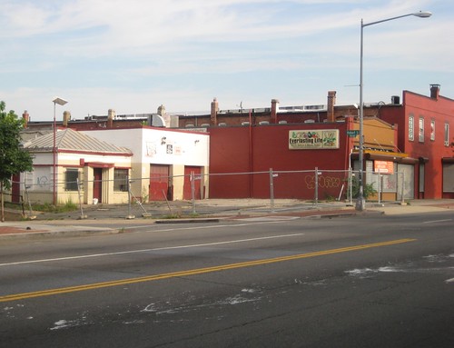 NW corner Georgia Ave. & Hobart Place, NW. Flickr image from 2012 by RockCreek.
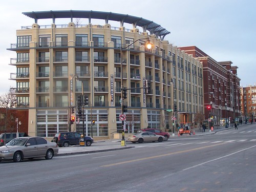
The difference in the neighborhoods these days, between where Metrorail stations are, such as at U Street and Columbia Heights around the Metrorail stations, and on 7th Street-Georgia Avenue between Rhode Island Avenue NW and New Hampshire Avenue NW--a seemingly long distance but only 1.5 miles in length--is striking.
Despite the presence of Howard University, the stretch of Georgia Avenue without subway service languishes significantly, perking up at New Hampshire Avenue, where the Metrorail station is located, and then falling off again, as the rest of the corridor within the city lacks subway service--it's 4.1 miles up Georgia Avenue from the Petworth Station to Silver Spring, although the last 7/10 of a mile is in Maryland.
Park Place apartments at Georgia and New Hampshire Avenues NW.
Similarly, a mixed use building called Progression Place--some office, a bit of retail, and a fair number of residences-- constructed at the S Street entrance of the Shaw-7th Street Metrorail station (pictured below, image from Google Street View) has helped to anchor a resurgence of the adjoining historic building stock in the abutting area, along with the revival of the Howard Theater.

This type of opportunity is missed at many stations, including the other entrance for this station, on U Street at 13th Street NW, etc.
Some people argue that transit is supposed to be about transit, and that economic development justifications are a misuse of the program. I disagree for a couple reasons.
First, any public infrastructure, be it roads, ports, electricity and water service infrastructure, or railroads, subways, and other transit services are known to be "primers" that enable development.
Second, public investment should achieve multiple objectives and maximized return, given the limited resources government budgets have to work with. That most of DC's neighborhoods proximate to Metrorail stations are healthy or undergoing revitalization--compared to the state of these places in 1976 before the Metro system began to open--should be celebrated, not denigrated.
Labels: economic development, neighborhood revitalization, transit and economic development, transportation planning, urban revitalization
posted by Richard Layman @ 12:35 PM&Permanent Link
![]()
![]()


10 Comments:
query -- why did the alignment change for U st -- but not H st?
Just eyeballing it, a "seperated blue line" could run from Metro center out to Minnesota ave? Or perhaps create an elbow for the red line?
off topic:
http://digitalcommons.law.umaryland.edu/cgi/viewcontent.cgi?article=2498&context=mlr&sei-redir=1&referer=http%3A%2F%2Fwww.google.com%2Fsearch%3Fclient%3Dsafari%26rls%3Den%26q%3Dbaltimore%2Bsegration%26ie%3DUTF-8%26oe%3DUTF-8#search=%22baltimore%20segration%22
slum clearance as a respone to S.Ct striking down segreatation ordinances.
Why? Because you could bend the Green line to serve U St and Columbia Heights. You couldn't bend the Red Line to serve most of H Street, it would've required an entirely new line.
Also, the Green Line was built later, they had more time to adjust the route. The Red line near Union station was the first section under construction. U St didn't open until 1991, Columbia Heights didn't open until 1999.
Some people argue that transit is supposed to be about transit, and that economic development justifications are a misuse of the program. I disagree for a couple reasons.
...Second, public investment should achieve multiple objectives and maximized return, given the limited resources government budgets have to work with. That most of DC's neighborhoods proximate to Metrorail stations are healthy or undergoing revitalization--compared to the state of these places in 1976 before the Metro system began to open--should be celebrated, not denigrated.
My read is that few people disagree that transit--particularly "premium" or rapid transit--has economic benefits or that those benefits are part of the reason to invest in transit. The divergence exists in the degree to which economic development goals drive transit investment decisions. Should economic development be a goal for rapid transit? Yes. Should it be the "raison d'être?" No. As you said, transit should achieve multiple objectives, and cost to achieve them given limited resources should be a major factor. I do not think there are many thoughtful people in the DC area who would disagree with that. I also don't think there are any people "denigrating" the success of neighborhood revitalization partially caused by the presence of Metro Stations.
It's worth noting that there are several stations in DC and the region where there is little to no development taking place (or is just now taking place after decades of inactivity), which highlights that neighborhood revitalization is caused by a wide variety of factors, not just access to a large rapid transit network. This is all the more reason to view so-called "development-oriented transit" projects with a healthy degree of skepticism.
Alex B. answers the question. It was about the Met. Branch right of way for the Red Line.
BUT the original separated blue line proposal does most of what Charlie suggests.
The Post graphic I reference a lot shows two stations on H St., at 8th and at Bladensburg, and reconnection with the Blue Line alignment somewhere after.
Later I suggested were the sep. blue line to be constructed, it could bring back the "Oklahoma Ave. station" as a way to enable housing development on the northern parking lots of RFK.
Now, I'd like to see another "separated blue line" leg go up from H Street, along Bladensburg to New York Avenue and South Dakota maybe--the problem with connecting Fort Lincoln is that it is seriously under-dense.
But that won't happen til after I am gone, if ever.
Anon. -- actually the lesson for failed "development oriented transit" at certain stations isn't about "development" or TOD so much as it is the underlying characteristics.
The typology of Metro stations, while not perfect, created for the bike and ped access study is an analogue for the characteristics that support denser development at transit stations.
Anyway, PG County illustrates the problems to a great degree, as I have written about a lot. In order for development to work, a lot more has to be done than just build the station.
And for it to promote walkability etc., is another thing. E.g., there is an article in the current issue of Mass Transit magazine about TOD in Greater Dallas. But as spookiness joked about me in a recent GGW entry about WMATA and "polycentricity" that's exactly the "problem" with the DART system. The project described is more like building a mini Tysons out in the suburbs.
The major tenant, State Farm, wanted transit access, but still prioritized freeway access more.
But I don't have the same level of skepticism that you do. Basically stations that are isolated and disconnected from the urban fabric have limited development opportunities.
Stations that aren't isolated, but where the transit network is limited (e.g., Baltimore) have less opportunity for ancillary development than stations in the WMATA system that are both well placed from the standpoint of urban design and part of a denser "network" of transit lines.
Charlie -- been thinking about the Civil War a lot since it's the 150th anniversary of the end, and the milestones leading up to it, such as Gettysburg.
We are still dealing with the racist legacy of slaveholding today.
... after 150 years!!!!!!!!!!!!!!!!!!!!!!!!!!!!!!!!!!! (or 33 years after that journal article!)
Well, I have no doubt that history always casts a shadow, even if we can't see it.
That said, I think from an urban perspective the issue was immigration stopped after 1920, and nobody came in to replace urban black ghettos. If you can't sell, you can't get out. Bascially halted the Chicago cycle.
Spanish harlem might be an exception (PR immigration of course a big exception in the 20th century).
But blaming the 3 car windows that were smashed last night on slavery seems a bit, well, attenuated.
racism as a structural element in the economy... but yep, not directly related to a particular battle. And the Southern segregation (now built into the economy) strategy to maintain subjugation without slavery post War is still with us.
As far as I can see, the only structural racism left in the economy is the continued discrimation against people from a different country in credit markets and employment.
A lot of what you are referring to is the "Matthew effect".
Really informative blog article.Really thank you!
Post a Comment
<< Home