It's been a drawn out process, but DC is in the process of creating transitways on 16th Street NW
It's been a drawn out process, but DC is moving on creating dedicated transitways on 16th Street NW, which is home to the S bus line between Downtown and Silver Spring. The line has upwards of 25,000 daily riders, which is the highest ridership bus line in the Washington metropolitan area.
-- 16th Street Bus Lanes Project website
-- 16th Street NW Transit Priority Planning Study, DC Department of Transportation
-- "D.C.'s 16th Street on track to get a bus lane," Washington Post, 2016
-- "Bus lanes coming to 16th Street, but it could cost you some parking," Post
July 27: Public Meeting
What: 16th Street Bus Lanes Project (Design Phase) – Public Meeting
When: Thursday, July 27, 2017 from 6 to 8 p.m.
Where: Columbia Heights Educational Campus - Cafeteria, 3101 16th Street NW
August 1: Public Engagement Event
What: 16th Street Bus Lanes Project (Design Phase) – Public Meeting
When: Tuesday, August 1, 2017 from 4:30 to 7 p.m.
Where: Two Locations: 16th Street NW at U Street and 16th Street NW at Irving Street
More recently, DC has introduced transitways painted red on a few blocks of Georgia Avenue, near Howard University and U Street, and recently extended this by one block between T and U Streets on southbound Georgia Avenue.
-- "Dedicated bus transitway on Georgia Avenue NW," 2016
Before the automobile completely dominated the DC metropolitan area's mobility paradigm, there were transitways. They were dropped around the time that Metrorail was implemented.
-- "We had bus lanes a half century ago and we can again, PlanIt Metro blog, WMATA, 2014
Dedicated transitways need to be considered a basic element within the urban mobility toolkit.
DC should take heart from similar kinds of very transformative projects elsewhere, and make sustainable mobility the priority, taking transformative measures here.
San Francisco. Over the weekend, I came across a vintage postcard of Market Street in San Francisco, showing four tracks-- two (!!!!!!) streetcar tracks in each direction.
Although motor vehicle traffic was still allowed there is no question that streetcars dominated the landscape, and moved far more people than a typical two track set up.
A four track set up has the capacity to move more than 100,000 people per day, even with comparatively slow streetcars.
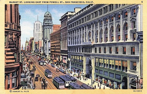
A long time ago, that was been slimmed back to two, and two streetcar tracks--one in each direction--is the typical set up across the US, as it is on Market Street today.
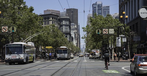
More recently, SF has introduced transit priority lanes on Market Street, and there are a variety of proposals for rebalancing throughput towards sustainable modes.
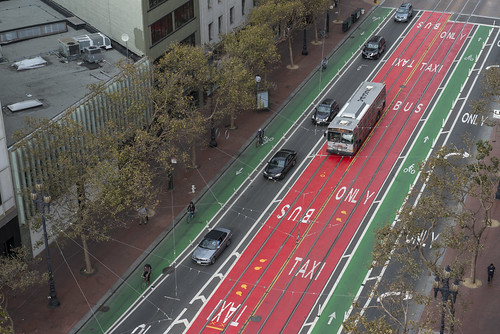
This and previous photo: SFMTA.
-- A Better Market Street, SF County Transportation Authority
King Street, Toronto. More recently, Toronto has begun the process of changing the traffic configuration to prioritize streetcar traffic on King Street. They will test for one year a change that disallows through traffic by motor vehicles.
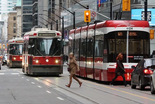
Streetcars at Yonge and King Streets, Toronto. Photo: Steve Russell, Toronto Star.
The line there, the 504, is the busiest in the city, moving more than 65,000 people daily. It makes sense to prioritize the streetcar, which moves far more people than cars, which make 20,000 trips on the street each day.
-- "King St. streetcar plan is a cautious first step with room to grow," Toronto Star
Imagine what streetcar throughput could be if there were four active tracks, and no motor vehicles, not even taxis.
Oxford Street, London. Oxford Street is one of London's main shopping streets, which pedestrian traffic greater than that of the King Street Streetcar. The street is clogged with buses and taxis--London's congestion charge does a reasonable job of reducing motor vehicle traffic.
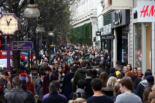
Oxford Street Shopping. This and next photo: Getty Images.
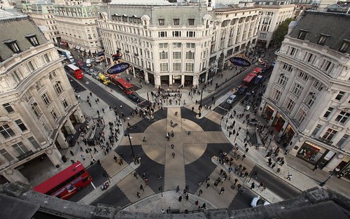
The diagonal crossing at Oxford Circus is Europe's largest.
Already, Transport for London is working to reconfigure bus service to move bus trips off the sections of the street with the most pedestrian traffic, and taxis will be banned as well.
-- "Oxford Street transformation to get underway by December 2018 as TfL and Westminster City Council launch consultation," City A.M.
-- "Four changes that need to happen before Oxford Street can be pedestrianised," City A.M.
-- "London's Oxford Street bus routes cut by 40%," BBC News
Not everyone is convinced it is the way to go.
-- "Oxford Street stores call on Mayor Sadiq Khan to tone down traffic ban," Evening Standard
Labels: busways/transitways, pedestrian planning, transportation infrastructure, transportation planning, urban design/placemaking


9 Comments:
Proposed middle lanes for BRT from Aurora to Denver on Colfax Avenue "all the time" vs. side lanes for bus only during rush periods.
http://www.denverpost.com/2017/07/26/denver-colfax-transit-plan-bus-lanes/
It'd be useful to create a typology here.
Transit mall.
Transit priority.
Pedestrian priority.
Pedestrian mall.
That way you can talk about other types in a rigorous way, compare/contrast.
E.g., I should have included Exhibition Road in London in terms of the pavement treatment, even though the road isn't fully closed to traffic.
http://urbanplacesandspaces.blogspot.com/2011/12/pro-pedestrian-road-paving-treatments.html
The traffic signal priority on 16th and U has never worked, although there is a 10 second delay on the lights and walk signals.
I can't speak for North of 16th, but U to the circle the problem is rush hour parking.
They stepped up enforcement a bit, but you still get delivery vehicles and ubers that will stop there.
DC has been much less aggressive than in the Williams era on towing rush hour cars. Seems more aggressive in towing street cleaning.
Remember? when cars were towed/ticketed during a snow event after Bowser became mayor, and the outcry, so the city rescinded the tickets.
Remember that Mayor Bowser lived/lives in the Outer City (her house is as close to MoCo as you can get and still be in DC) and she worked for MoCo Govt. which is quite car-centric too.
Our city's elected officials mostly hail from the Outer City.
... I guess that's why in other places they are putting the transitways in the middle of the street, but that makes the stops tough.
I seem to have mislaid the book _Transit Street Design_, but there is a section on prioritization of bus transit. I need to find it.
2. LA backs down on road diet.
http://www.latimes.com/local/lanow/la-me-ln-vista-del-mar-lanes-20170726-story.html
We've been talking about Blair Road from Kansas Ave. to Aspen Street in terms of road dieting -- it's four lanes and "banked" by the wall of the Metropolitan Branch railroad/Metrorail abutment and cars travel very fast. But the road diet would come via the MBT and it is a suboptimal routing because of the traffic.
A member of a different ANC committee came up with an alternative routing on 3rd St./North Dakota that I think is far superior for the MBT, but then it takes "fixing"/tweaking Blair Road off the table. And it should be no surprise that in the area I am talking about the placemaking elements/number of vacant-undermaintained properties is suboptimal.
... Which is why I now argue for commuting tunnels on North Capitol/Blair Road, New York Avenue, etc. to divert through traffic.
I'd even consider a LR tunnel for 16th Street except for the tricky problem of Rock Creek Park -- I guess it could be a bridge on the underside of the road bridge. Or conversely, tunnel for traffic and LR.
I do think the painted lanes on Georgia Avenue make a difference. It was associated with some removal of parking. But it's not a particularly long segment. There is no signal priortization of course.
any thoughts about this?
https://www.bizjournals.com/washington/news/2017/07/28/foulger-pratt-has-more-in-storein-eckington.html
Intersting.
Not a RE expert.
I think there have been a lot of very marginal projects in the last few years.
For instance, the remodel on 20th and M, which included a very large retail space on M st that is now -- a crappy bank.
I suspect the large CRE players may be hunkering down, and turning land they own into projects like that generate cash but aren't expensive enough to fully build out.
Again it a financing game, and if the banks won't lend the money you're not building a new rental.
Condo market is desperate for inventory.
off topic, big hairy project.
https://www.nytimes.com/2017/07/31/world/europe/london-crossrail-uk-brexit.html?_r=0
Again if you want to measure Silver Line success, you've got to look at the development (lots of stuff in Tysons, no evidence that is more of a walk friendly place, good for Reston, unclear for Loudon). and getting workers out there (is traffic better as a result of SL?)
Oslo instituting parking ban as a way to discourage driving to the city center
https://www.fastcompany.com/40434409/if-you-cant-ban-cars-downtown-just-take-away-the-parking-spaces
Post a Comment
<< Home