======
Addition, May 6th, 2020
Re-reading the paragraph below:
In 2017, I did some of my best writing ever, partly spurred by interaction with Paul Meissner, who did a "fantasy" transit map for me, as well as a current systems map, but including both subway and railroad services, on the Purple Line.
I failed to acknowledge blogreader
Ed Drozd. After my Purple Line piece on a program, which mentioned creating "sustainable mobility corridors" on streets like Fenton Avenue in Silver Spring, he asked me to define what I meant more fully.
At first, my response was likely to have been somewhat rote, but I made a bunch of "site visits" and started thinking more broadly. That led to the multi-part series on Silver Spring as an innovation district and sustainable mobility district.
I thank him for spurring me on.
=====
This is being republished with the addition of a fourth point on the general network, that opportunities to leverage the new transit infrastructure as a way to drive the creation of "hubs" and centers is being missed in Prince George's County specifically, using New Carrollton as an example, but with a link to "
Missing a great chance to create a transit hub: New Carrollton," by Alex Block/City Block.
It was published in January but I just came across it.
=====
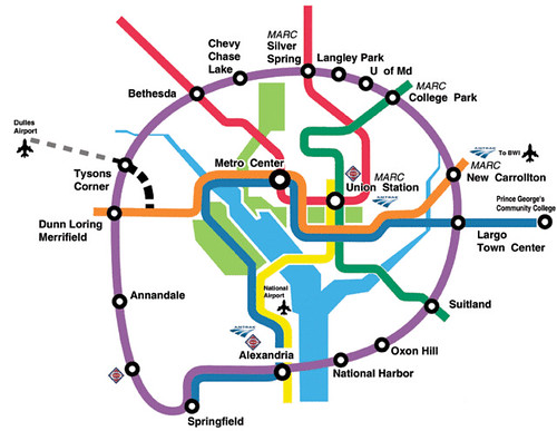
Wikipedia image.
The Purple Line light rail program is building a 21 station, 16 mile line which will connect both legs of the Red Line Metrorail, the north leg of the Green and Yellow Lines, and the eastern end of the Orange Line, along with connections to all three MARC commuter lines.
Purple Line to open a small section in late 2022. It was recently announced that due to construction delays, the line will open in two phases, with a short section in 2022 just so they can say they opened in 2022, and the rest of the system in 2023, ("
Purple Line will open in two phases, with first part in Prince FGeorge's, state says,"
Washington Post). From the article:
Rather than open the full Purple Line a year late, Maryland transit officials said Thursday that they will open it in two phases, with the first segment carrying passengers in Prince George’s County in late 2022 and the rest opening the next year.
While the 16-mile light-rail line was scheduled to open in March 2022, officials said construction delays mean the full line couldn’t open until at least April 2023.
Project officials said they want passengers to ride at least part of the line by the end of 2022.
The length and exact location of the first segment hasn’t been determined, but it will include a two-mile test track being built along Veterans Parkway (Route 410) between New Carrollton and Riverdale Road, state transit officials said.
In 2017, I did some of my best writing ever, partly spurred by interaction with Paul Meissner, who did a "fantasy" transit map for me, as well as a current systems map, but including both subway and railroad services, on the Purple Line.


I wrote a many part series based on the concept that when developing new transit infrastructure it makes sense to drive complementary improvements across the transit network, to make both the existing network and the new expanded network more successful.
So the idea then is about a "transit network improvement program" which is "complementary" to the introduction of new transit infrastructure.
So this was a proposal for "the" Complementary Transit Network Improvement Program that should have been created in association with the Purple Line.
The article series
--
Setting the stage for the Purple Line light rail line to be an overwhelming success: Part 1 | simultaneously introduce improvements to other elements of the transit network
--
Part 2 | the program (macro changes)
--
Part 3 | influences
--
Part 4 | Making over New Carrollton as a transit-centric urban center and Prince George's County's "New Downtown"
-- PL #5: Creating a Silver Spring "Sustainable Mobility District"
--
Part 6 | Creating a transportation development authority in Montgomery and Prince George's County to effectuate placemaking, retail development, and housing programs in association with the Purple Line
--
Part 7 | Using the Purple Line to rebrand Montgomery and Prince George's Counties as Design Forward
Within the list of items, #20 was "Create "sustainable mobility" corridors in Silver Spring (and other places), complementing the new PL," and reader Edward Drozd asked me to expand the concept.
At first it was going to be reasonably simple, but doing field visits over a couple months, it became a much bigger idea, repositioning the core of the Silver Spring conurbation as a "sustainable mobility" district/innovation district, and a multi-part series.
-- PL #5: Creating a Silver Spring "Sustainable Mobility District"
-
Part 1: Setting the stage
-
Part 2: Program items 1- 9
-
Part 3: Program items 10-18
-
Part 4: Conclusion
-
Map for the Silver Spring Sustainable Mobility District
-
(Big Hairy) Projects Action Plan(s) as an element of Comprehensive/Master Plans
-
Creating the Silver Spring/Montgomery County Arena and Recreation Center
WRT the general program of "complementary network improvements" that I outlined, one is starting to be implemented, but only one.
Here's the full list which reflects one addition included in the later post, "
A Purple Line update: the downside of "Public Private Partnerships" -- they are contracts, not partnerships (+ a Penn Line infill station):
- Change the WMATA Metrorail map so that it includes the Purple Line and regional railroad services
- Integrate the Purple Line light rail line into the Metrorail fare system
- Integrate MARC fares into the SmarTrip/ CharmCard fare media system
- Introduce bi-directional passenger rail service between DC and Frederick on the MARC Brunswick Line
- Consider charging DC-Montgomery County trips on a bi-directional Brunswick Line using the Metrorail/Purple Line tolling/fare schedule. That would treat mileage from railroad trips in the context of a complete (linked) trip on railroad+subway+light rail as a single fare
- The White Flint Sector Plan calls for an infill MARC station. Plans to build that station should be accelerated as part of this proposal
- Build an infill train station in DC on the Penn Line, serving the New York Avenue corridor
- Provide integrated train arrival information screens at Metrorail, Light Rail, and MARC stations
- Provide integrated bus arrival and departure information screens at Metrorail, Light Rail, and MARC stations
- Bus service in certain corridors between DC and Maryland should be extended and/or frequency increased to better link these areas to the new light rail service
- Montgomery County bus system improvements with the launch of the Purple Line and bi-directional service on the MARC Brunswick Line should include launch of planned Bus Rapid Transit services
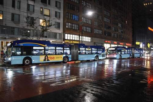
- Rearticulate, rebrand, and reposition-extend the Prince George's County TheBus bus transit service. Change the name of the service and the graphic design of the bus livery
- Consider a redesign and rebranding of the metropolitan area's bus systems into an integrated framework, comparable to that of GoTransit in the Raleigh-Durham area
- Set the opening of the Purple Line as the deadline for the integration of the MARC Penn Line and VRE Fredericksburg Line into one combined railroad passenger service
- Set the opening of the Purple Line as the deadline for the implementation of a full-fledged integrated Night Owl bus network for the DC metropolitan area
- Create a cheap weekend pass to use the local transit network, especially Metrorail
- Incorporate quantum improvements in bicycle facilities across the mobility network in association with the launch of the Purple Line
- Rearticulate transportation demand management programming and services in conjunction with the PL launch, including a single network of "customer information centers"
- WMATA should upgrade its Metrorail station bus shelters
- Create "sustainable mobility" corridors in Silver Spring (and other places), complementing the new PL.
But over time, I realized I missed a few items.
Meta-network improvements
In the original series I deliberately didn't include items outside of improving existing program and services within the footprint of the DC area transit network. So I didn't include more planning-related items, or items outside of DC, but still relevant.
 Original Purple Line concept as rendered by the Metro DC chapter of the Sierra Club.
1.
Expansion planning for the Purple Line on the south. I didn't include beginning expansion planning for the Purple Line, at the very least southwest from New Carrollton to connect to the Blue/Silver Lines at Largo Town Center, the Green Line at Suitland, and even the Yellow/Blue Lines across the Potomac River in Alexandria.
2.
Expansion planning for the Purple Line on the north As well as planning for extension on the northwest from Bethesda to Virginia.
 Baltimore Light Rail train at Penn Station.
3.
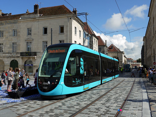
New vehicles for Baltimore Light Rail. At the same time, Maryland MTA should have used the contract with the Purple Line train vehicle provider to provide upgraded transit vehicles for the Baltimore Light Rail, which is pretty clunky (pictured at right).
By contrast, CAF Urbos light rail vehicles that will be used for the Purple Line are quite attractive, and replacing the light rail vehicles in Baltimore could have a transformative effect on rail transit planning there (also see "
From the files: transit planning in Baltimore County." 2012).
 Local stuff that I missed
Silver Spring
Local stuff that I missed
Silver Spring
These items are relevant to the Silver Spring series, although Item #2 in the general list, "Create an inter-city bus waiting station on the ground level of the Silver Spring Transit Center;" could be in either list.
The only movement on any of the items in the original list is that the area is moving forward on creating some type of business improvement district mechanism.
1.
Extend the Ellsworth Avenue Pedestrian Mall to the Metrorail Station. I wrote a piece in 2018 about extending the pedestrian district from Ellsworth Avenue between Georgia Avenue and Fenton Street west to the Silver Spring Metrorail Station, ideally anchored by a Boscovs Departmenet Store in the redeveloped Discovery HQ ("
Making "Downtown Silver Spring" a true open air shopping district by adding department stores").
 Spine of the Wiesbaden Germany Pedestrian Zone. From Pedestrian Zones: Car-Free Urban Spaces, published by Braun, page 93.
I know this is a bit of a stretch, but department stores can still thrive in certain situations, and I believe that Silver Spring is one such place.
Expanding on the pedestrian district there would be a model best practice for the DC area. Note that as it is, this pedestrianizing district is one of the only ones in the DC area that anchors night-time activity, something I've meant to write about for a couple years.
2.
Pedestrianizing part of Fenton Street. I should have suggested some pedestrianizing (but still with transit) of Fenton Street, at a minimum from Colesville Road to Wayne Avenue. Bus access would still be maintained.

3.
Add an Upper level exit from the Silver Spring Metrorail Platform. A group of people in Silver Spring are advocating for exits from the platform to the southeast area of the station complex without having to go to the ground floor to exit.
It turns out WMATA has studied this back in 2014, more in terms of integrating the PL platform into the station complex ("
Study Recommends New Mezzanine to Connect Red/Purple at Silver Spring," PlanIt Metro), But it would both better connect the PL platform to the Metrorail platform, as well as provide a connection from the Metrorail platform to the surface above.
WMATA believes this would end up being the most used entrance/exit for the station.
4.
Add at least one children's playground to the urban core. My thinking has evolved on accommodating families, especially little kids with lots of energy ("
Keeping Cities from Becoming “Child-Free Zones”,"
Governing Magazine).
While Downtown Silver Spring has a small splash park, and in the winter an ice rink, that's not enough.
Inspiration Playground, Bellevue, Washington.
While the district doesn't need to develop a full-fledged focus on families, as it is more adult-focused, having a couple small playgrounds would help to expand the range of amenities provided for other demographics.
5.
A brief follow up to the proposal for rooftop fields, Item #8 in
Creating the Silver Spring/Montgomery County Arena and Recreation Center." In June 2019 I wrote about the new rooftop court for the Washington Kastles professional tennis team ("
Revisiting stories: rooftop recreation and sports facilities in cities"). It shows it can be done.
Additions to the general program of "Complementary Transit Network Improvements" as proposed in association with the development of the Purple Line light rail program
Ft. Lauderdale Sun-Sentinel photo.
1.
Intra-district shuttle services within the catchment area of the individual light rail stations. The discussion in the Silver Spring series, "Item #5: Rearticulate parking services on Fenton Street/across the Silver Spring Triangle to accommodate cycletracks/removal of street parking," includes a form of intra-district transit shuttles, there using electric vehicles to move people from parking to destinations, etc.
This concept needs to be extended to mobility sheds of the individual light rail stations, to provide a way for people to get to and from the stations without having to drive.
-- "
Updating the mobilityshed / mobility shed concept," 2008
The diagram below illustrates the idea, although the catchment area is illustrated for bicycling and walking. Transit extends the shed further outwards.
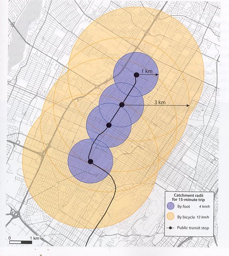 Catchment area of public transit stops for pedestrians and cyclists. p. 135, _Planning and Design for Pedestrians and Cyclists: A Technical Guide, published by VeloQuebec.
A lot of transit agencies are now hyped on this concept, re-termed "microtransit" and there are various examples being piloted by transit agencies across the country.
Lyft, Uber, Via and other firms offer to be the contractor for these services, and they have been the impetus for developing such services in many places.
But the concept has been around for decades, just not integrated in a structured way into the transit delivery framework, although the Montreal transit system has called it taxi collectif and offered it for decades, and it operates on the edges of their system.

This
Ft. Lauderdale Sun-Sentinel article is very good about how the small electric shuttles work and tend to be funded, "
They're like Uber but free: New electric shuttles popping up all over South Florida." This piece describes the microtransit shuttle program in a community in Orange County, California ("
OC Flex program makes getting around Aliso Viejo easier,"
Orange County Register).
And the success of a program in Colorado ("
Popularity of an on-demand service surging for a Colorado Agency,"
Metro Magazine), where 25% of the ridership moves to and from a transit station and two major office complexes.
But there are a great number of other examples.
While the programs have small vehicles which are open to the elements and have a maximum capacity of 6-8 people, t
here is a 15 person enclosed vehicle that is reasonably priced.
2.
Create an i
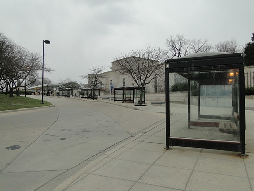
nter-city bus waiting station on the ground level of the Silver Spring Transit Center. This point has many influences, including seeing all the people stand outside waiting for the various MTA commuter buses on Colesville Road, close to the intersection with East-West Highway, west of the Silver Spring Metrorail Station.
WRT the Silver Spring Transit Center which I have reviewed separately ("
Multiple missed opportunities in the creation of the Silver Spring Transit Center" and "
Updating my review of the Silver Spring Transit Center") I realize now that inter-city bus services, including long distance commuter buses, plus the transit information center and restrooms, plus visitor services which are not currently provided, should be accommodated by building an extension outward from the existing footprint, on Colesville Road, on the opposite side of the Metrorail station.
Instead they are provided in a section of the center set way back within the SSTC on the second floor, and inter-city buses get a bay on the second floor. But it would be a lot better for them if they didn't have to deviate too much from Colesville Road.
The area where such a facility could be placed is shown on the above photo, with the red box. Although right now this entire area is blocked off for the construction of the Purple Line.
One model for how to do this is the main bus station for the Charlottesville transit system. It's on two levels.
The upper floor serves the pedestrian mall, and that's where the visitor center is.
The ground floor serves the bus system, and has a waiting room and restrooms. (I don't have a good photo.) It doesn't have a coffee shop/cafe, one could be included.
The Merseyrail system has information centers that double as convenience stores, not with full cafe functions, but they sell coffee and sundries. (The machine that produces the coffee does a good job.) That could be a model for how to do it here.
3.
Adding a new MARC service to the I-270 corridor. In other pieces, I think I have suggested a MARC line in the I-270 corridor.
And frankly, you can't build a new line in the timeframe of the Purple Line construction process, which is less than five years. Maybe this needs to be in a separate category, as a long term complementary transit network improvement, since it can't be finished within the same time frame as the PL.
Nevertheless, it needs to be considered in the context of corridor management ("
Maryland HOT lane study versus "corridor management"") and transportation demand management.
Instead, because the private sector will pay for it, Governor Hogan wants high occupancy toll lanes ("
Hogan toll lanes on lower I-270 first,"
Washington Post) and is even open to the idea of a monorail ("
A Montgomery developer has a plan to ease traffic on I-270: Build a monorail and "
Monorail advocates say Maryland officials will consider it for I-270,"
Washington Post) which doesn't make a lot of sense. (The
High Road Foundation has been created to promote a monorail in the I-270 corridor.)
But not transit. Even though the capacity of transit vehicles as a line, either for bus or rail, is much higher than a HOT lane, which probably has a maximum throughput of 2,200 vehicles per hour per lane.
The monorail proposal is a service from Frederick to Shady Grove Metrorail Station.
I think the distance between the I-270 corridor and the existing Metropolitan Branch railroad line is far enough to justify another railroad line, for transportation demand management purposes. It could be constructed as cut and cover, under the freeway traffic lanes, and would have to be electrified.
It could provide direct service to Bethesda which MARC doesn't do and even underground along the Wisconsin Avenue corridor into Georgetown and Arlington County and Tysons, Virginia, which would make it a positive addition to the transit network, expanding service to areas not currently served.
Yes, it wouldn't be cheap to construct. Not so much the part under the freeway, but the parts getting to and from the freeway right of way.
The Alameda Rail Corridor serving the Ports of Los Angeles and Long Beach and the Reno Retrac project are examples of building below grade troughs for railroad service. The Alameda trough isn't covered, but the Reno project is, with "lids" ("
Opposed early on, ReTRAC trench is fulfulling its promise,"
Northwest Nevada Business Review) comparable to how decks over freeways are being constructed for parks like the Klyde-Warren Park in Dallas ("
How Klyde Warren Park Was Built,"
D Magazine) or the
Capitol Crossing development in DC which was constructed by building a deck over I-395 adjacent to Massachusetts Avenue.

More recently, the State has decided to defund the Corridor Cities Transitway ("
Maryland cuts funding for Corridor Cities Transitway,"
Post) and a comment on the
Post article made the point that anything that doesn't support HOT lanes, the state isn't too concerned about.
4.
The opportunity to build broader hubs is likely missed | New Carrollton as an example of falling flat on leveraging transit infrastructure to drive broader improvements. #4 in the series, "
Making over New Carrollton as a transit-centric urban center and Prince George's County's "New Downtown"," is but a slight revision of a piece I first wrote in 2014.
I just happened across a January 2019 piece, "
Missing a great chance to create a transit hub: New Carrollton," by Alex Block/City Block, which addresses this in a more detailed way in terms of the connections between the different modes, as well as leveraging the urban design elements.
When I first wrote the New Carrollton piece, a PG-based blogger responded, making the point that the "New Downtown" should be Largo Town Center, since PG County has been locating agencies there.
But that's bad advice. For the most part, there is nothing "urban" or Downtown-like (see "
The 20 Ingredients of an Outstanding Downtown," Roger Brooks International) about Largo Town Center, and that's true of all the PG County facilities that are being sited there. They are each separate, disconnected properties.
New Carrollton has the opportunity to be made over. And it would behoove Prince George's County to do so. Although this kind of vision is beyond their capacity.
--
Putting the Urban in Suburban: Art and Business of Placemaking, Canada
--
Reinventing Suburban Business Districts, Urban Land Institute
--
Reinventing America's Suburban Strips, Urban Land Institute
--
Revitalizing Suburban Downtown Retail Districts, Delaware Valley Regional Planning Commission (Greater Philadelphia)
Labels: busways/transitways, change-innovation-transformation, fixed rail transit service, public realm framework, transit, transit marketing, transportation planning, urban design/placemaking

 19. WMATA should upgrade its Metrorail station bus shelters.


