Maryland HOT lane study versus "corridor management" and regional scaled transportation planning
The Maryland Transit Opportunities Coalition sent out a press release about problems they see with Maryland's study for the addition of high occupancy toll lanes to I-270 and I-495. The first round of public meetings starts tonight:
They prefer a more balanced set of responses, including more investment in transit, while this particular transportation planning initiative is solely road focused. The proposal is to add lanes exclusively for people willing to pay tolls, on the Capital Beltway (I-495) and on I-270. These lanes would link up to comparable infrastructure in Virginia.
MTOC makes the point that given the experience with tolls on newly tolled I-66, where sometimes tolls are greater than $41 ("A quick comment on I-66 Tolling"), the impact of this addition would be limited mostly to high income households.
The program is being driven by interest in the private sector ("Public gets chance to weigh in on Md. toll lane plans," WTOP; "Speedy selection process ends with Maryland official’s former firm being chosen for project," Washington Post). Still they have been in state highway plans since 2005.
-- Maryland’s Statewide Express Toll Lanes Network Initiative
Last week I was riding up Georgia Avenue in Montgomery County in the late afternoon and the traffic was backed up for one mile or more northbound to the I-495 entry ramps.
It made me think that it would be worthwhile to connect the Maryland initiative with ideas I've suggested over the years to create a system of tolled "commuter road tunnels" under major thoroughfares within DC, to mitigate the traffic impact on the abutting neighborhoods, but also speeding up traffic and maintaining the relevance of DC's central business district as a regional center for commerce and employment.
Two pieces discuss "underground toll commuter routes" ("Tunnelized road projects for DC and the Carmel Tunnel, Haifa, Israel example--tolls" and "London Mayor proposes roadway tunnels to divert surface motor vehicle traffic and congestion") on routes such as North Capitol Street-Blair Road, 16th Street, and New York Avenue, and these pieces cover the idea of "corridor management" in the I-270 corridor, but in terms of continuing on to DC ("Transportation network interruptions as an opportunity: Part 2 and "Transportation network service interruptions part 3: corridor/commute shed management for Northwest DC and Montgomery County, Maryland).
Given the traffic I witnessed on Georgia Avenue, that street and maybe Connecticut Avenue ought to be included in such a network.
But while previously my suggesting about a Blair Road-North Capitol tunnel (ironically comparable to the originally suggested "North Central Expressway" in highway planning dating to the 1960s) would have ended the route at Georgia Avenue, obviously such a route should continue on into Maryland for some distance. Same with Connecticut Avenue and 16th Street.
Ideally, were we to have a true regional transportation planning system, you could integrate this kind of road planning between DC and Maryland because this initiative might be the only way to bring such a complete network about, while also considering transit expansion both in terms of bi-directional railroad service between DC and Frederick Maryland (item #4 in this piece) and between Bethesda and the Tysons District of Fairfax County via I-495.
While not exactly comparable, Orange County and Riverside County in California have cooperated to extend the SR-91 Toll Road into Riverside County ("91 Express Lanes in Orange County paved way for new toll lanes opening Monday in Riverside," Orange County Register).
======
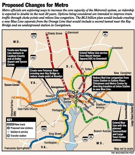
Besides the development of three different bus rapid transit programs in the metropolitan area, the comparable planning failure I'm thinking about would be DC's failure to take advantage of Virginia's Silver Line Metrorail expansion as a way to bootstrap its continuation into DC, as the old proposed "separated blue line." I first wrote about that in 2006 ("Blinking on urban design means you limit your chance for success").
Graphic published in the Washington Post in 2001, outlining WMATA's plan for a separated blue line

Paul Meissner/Richard Layman concept for an expanded Metrorail system including a separated Silver Line in place of the original separated blue line proposal

Labels: corridor management, freeways, tolls and toll roads, transit planning, transportation planning


2 Comments:
https://www.washingtonpost.com/local/trafficandcommuting/rebuilt-beach-drive-to-reopen-friday/2019/09/25/a6fcd802-dee9-11e9-b199-f638bf2c340f_story.html
In Maryland in the I-270 corridor, Hogan wanted HOT lanes and they weren't approved.
So he announces that the state will have to cut back on other mobility priorities.
Maryland says it needs to cut transit, highway projects to offset lost private investment in toll lanes plan
https://www.washingtonpost.com/transportation/2021/06/22/maryland-highway-projects/
and there is a lack of consensus on what to do.
WTOP: Maryland, Montgomery County leaders lack consensus on how to ease I-270 congestion.
https://wtop.com/maryland/2021/06/maryland-montgomery-county-leaders-lack-consensus-on-how-to-ease-i-270-congestion/
There still wasn't really a good corridor management approach.
I've argued considering rail transit under the freeway should be considered. But the thing to do would be a massive collection of license plate data and figure out the origin and destination data (destination data would be almost impossible, but you could capture which direction at the Beltway and at city border entrances).
Post a Comment
<< Home