Rebuilding Place in the Urban Space

"A community’s physical form, rather than its land uses, is its most intrinsic and enduring characteristic." [Katz, EPA] This blog focuses on place and placemaking and all that makes it work--historic preservation, urban design, transportation, asset-based community development, arts & cultural development, commercial district revitalization, tourism & destination development, and quality of life advocacy--along with doses of civic engagement and good governance watchdogging.

Thursday, June 01, 2023

Disneyland doesn't have transportation demand management planning requirements

A couple weeks ago, I mentioned Robert Niles, the "amusement parks" columnist for the Orange County Register.  I always learn from him.

And a few weeks ago I wrote about how at the metropolitan scale, most communities don't have transportation demand management requirements for stadiums, arenas, concert facilities, etc.

-- "To shift away some trips from the car, we need super robust transportation demand management processes"

Niles writes ("Here’s what’s missing from DisneylandForward")about Disney's long range plan for Disneyland in Anaheim, making the point that transit is missing from the plan.  From the article:

The Disneyland Resort has been putting out an impressive case for new rules to govern its development through its DisneylandForward proposal. Disneyland President Ken Potrock detailed the resort’s plan to OC Forum last week, highlighting the economic benefit to Anaheim and the region if Disneyland gets the OK to build hotel and attractions on space that has been reserved for parking lots. 

But watching Disneyland’s presentations and talking with resort representatives over the past year, I can’t shake the thought that something is missing from DisneylandForward. ... as a Southern California native, resident and advocate, there is an element that I wish that Disneyland would have been able to include in at least its top-level vision for the resort. 

Rail and bus transit service to Tokyo Disneyland. 

Disney’s theme park resorts in Tokyo, Shanghai, Hong Kong and Paris all feature train connections to their local mass transit networks, including local airports. On the best of these, Disneyland Paris lies just 10 minutes from Charles de Gaulle airport via France’s high-speed TGV network. Even Florida is developing a high-speed rail system, though Walt Disney World declined to have a station on its property after developers included a stop at the Universal Orlando Resort. There is no regional transit train station envisioned in DisneylandForward, however. 

Blame for that must spread beyond Disney. Where is the robust mass transit system to which a Disneyland station would connect? Despite continued development on many important components of such a system, including Metrolink and Los Angeles’ Metro, there is no route on the drawing board that would get a Disneyland visitor to the resort from any local airport faster than driving a car.

Addressing that should have been an element of the 2028 Olympics planning for Los Angeles, irrespective of Disney's long range planning.

But overall, this is the failure of the "metropolitan planning organization" system in the US, which coordinates transportation across a region--and in Southern California the counties are so big they each comprise separate MPOs--because they often don't have the most basic requirements for coordinating uses with transportation and transit capacity.

There are public bus lines that serve Disneyland, but the trips are not direct.  And private shuttles from the airports, but not necessarily top branded nor coordinated with the Disney Resort reservation system.  

Interestingly, Disney is the world leader in the management of customer experience, and you would think they would make this a priority.  Same with the Visit Anaheim tourism promotion organization.

=====

Note that in Florida, Disney used to have the Disney Express shuttle service from airports to the campus.  

But ride hailing led to significant drop off in ridership, so they eliminated the service, which was built into ticket and hotel reservations, although it was operated privately.  Although private sector options have replaced the cancelled service, but it isn't built into the reservation system.

-- "Transportation demand management requirements as a part of campus planning for large sites: Disney World bus services," 2022

A similar service could be operated to serve Anaheim Disneyland in the interim.

Labels: , , , , , , ,

Wednesday, May 10, 2023

To shift away some trips from the car, we need super robust transportation demand management processes

Before moving to Salt Lake, I believed all the puffery in the planning press about how advanced the region is due to forward planning processes like the environmentally focused "Envision Utah" initiative.  Then I moved here and learned that the region is the epitome of the sprawl land use paradigm.

Salt Lake County.  Photo: Rick Bowmer, Associated Press.

Although I will say that it has a decent if nascent light rail system, complemented by a single line commuter rail, and decent bus service.  If you live within that transit footprint, it works decently.  But there isn't a rush to expand it, or to create conditions where sustainable modes are first choice for getting around.

The State Department of Transportation, which probably should be called the Utah Department of Cars and Trucks, has a proposal to widen I-15 through Salt Lake City to Farmington in Davis County to 6 lanes in each direction--it's four lanes now.  

I-15 in Davis County. Rick Egan, Salt Lake Tribune.

Note that in Southern California, where I was a couple weeks ago, most freeways are 6 lanes on each side--but the population of Los Angeles County is 5x greater than Metropolitan Salt Lake.

A recent article on the proposal ("UDOT admits I-15 widening will cut into parks and school ball fields, while demolishing scores of homes and businesses," Building Salt Lake) lists a bunch of the comments of alternatives and UDOT's rejection of the suggestions.  

It happens that Salt Lake proper mostly has enough right of way within the current configuration for widening, but some properties--residences and commercial buildings, would be taken as part of the construction project.  There's no question there would be a diminishment of quality of life for the neighborhoods abutting the freeway.

I was talking with Suzanne about this and 

1.  Corridor management.  For the most park, transportation agencies don't do corridor management, where they coordinate all modes within a mobilty corridor, like I-15, which is paralleled by the Frontrunner commuter rail line, and has light rail transit too.  I wrote about this wrt DC and Maryland and I-270/DC arterials ("Washington Post letter to the editor on repair-related closure of Rockville and Shady Grove Stations and corridor management," 2021").

Although UDOT says they took the Frontrunner and current expansion plans into account.

2.  Transportation demand management as a priority.  How the field of transportation demand management was created in Melbourne, when David Engwicht, working with people fighting the widening of a freeway, realized that if they could reduce the number of vehicle trips, the need for road widening would be diminished.  

He wrote about this in the book Reclaiming Our Cities And Towns: Better Living Through Less Traffic, and Victoria State in Australia is the world leader in TDM.

3.  Transportation Management Districts as an implementation mechanism for trip shift.  Places like Montgomery County Maryland have created Transportation Management Districts for certain high congestion densified areas of the county and employers of a certain size have to survey employees about how they get to work and employers are supposed to work with them to shift trips to transit and sustainable modes.

However, it's a pretty half-a**** program without a lot of meat.  In those areas, a lot of people use transit because parking is expensive and they have (or at least had) decent public transit options between Metrorail, MARC commuter rail, and bus service--plus Montgomery County is adding east-west light rail through the Purple Line.

Note that Victoria State, Arlington County, Virginia, and Whatcom County, Washington have much more robust trip shifting programs.

4.  Matching land use to transporation capacity.  The Netherlands is not hal-a**** about this in terms of land use planning.  They have a planning model where uses are rated for their transportation demand, and places are rated for their ability to respond to demand, with an emphasis on trips being conducted by sustainable modes (transit, walking, biking).  High transportation demand uses can't be located in areas with weak transit--such a requirement is pretty much devoid across the US.

-- "The ABC location policy in the Netherlands: ‘The right business at the right place’," 

5.  Accommodating Trucks.  As charlie points out, the Interstate highway system is designed to facilitate truck movement.  I-15 is a corridor with a lot of truck traffic.

One of the comments suggested undergrounding the expansion.  FWIW, I believe undergrounding can be good when it comes to train service, but what about long distance trucking.  Although I've also suggested shifting longer distance truck trips to night time, but that it is a different kind of problem.


Basically, for all the talk of Envision Utah, the Salt Lake region doesn't do corridor management (yes, it has commuter support programs comparable to those in every other metropolitan area), transportation management districts, or coordinate transportation demand with land use decision making.  And no one is really thinking about the truck issue in innovative ways.

Transportation demand management also comes up in DC.  There is a letter to the editor ("The real world of parking without minimum requirements") in the Washington Post about how reducing parking requirements for multiunit buildings merely shifts cars to street parking.  The writer discussed one particular example, and likely is wrong anyway, since mostly, multiunit building residents aren't eligible for street parking permits.

But the basic questions were unasked.

The reality is that at least when proximate to Metrorail, trips by car and car ownership is significant reduced in multiunit buildings.  But that has been by the choice of the tenants, and was facilitated by a transit system that once operated much more reliably than it does at present.  In short it's trickle down.

DC needs to be much more active when it comes to TDM (it does have some requirements), including the creation of Transportation Demand Management Districts (I suggested this for DC starting in 2005!!!!!!!!) and protocols for shifting trips and reducing car ownership--for example, car sharing systems are a great way to support not owning a car.

In short, determine why best practice buildings work the way they do--e.g., near Takoma Metrorail Station, at least before covid, the multiunit buildings only generated 25% of rush trips by car, and many fewer households owned cars--and work to duplicate these characteristics across the city.

Labels: , , , , , ,

Saturday, January 28, 2023

Some transit matters in Utah

1.  Poor transit to ski resorts in Salt Lake County.  During covid, the Utah Transit Authority had a hiring freeze, which now means that they don't have enough drivers and are cutting service as a result.  One of the services cut, partly because they don't have enough drivers with the experience to drive in serious snow and mountain/canyon conditions, is the UTA Ski Bus service, which serves Big and Little Cottonwood Canyons, home to four popular ski resorts.

So the County Tourism Office, Visit Salt Lake, has contracted with a private operator to provide additional service ("New ski shuttle to launch in Cottonwood canyons this week," Salt Lake Tribune).  It's $10 round trip, which seems reasonable.  Although equity based options should be made available too.  From the article:

The “Cottonwood Connect” ski shuttle will provide passengers $10 round-trip rides to either Alta and Snowbird in Little Cottonwood Canyon, or Brighton and Solitude in Big Cottonwood Canyon, on a first-come, first-serve basis beginning Thursday morning.

Service will run on Thursdays, Fridays, Saturdays and Sundays, as well as holidays, through April 16. Reservations must be made online in advance.

Riders can choose from 11 different locations for morning pickup — such as the Highland Park park-and-ride, or the Cottonwood Hyatt Place hotel. Then, they can select their ski resort destination, along with a time slot for return from the slopes.

A full list of stops and routes for the service are on the Visit Salt Lake website, here Cottonwood Connect.
But this should be a basic function of the local transit authority and it is damning that they can't pull it off.

2.  Especially since the Utah Department of Transportation's study of Little Cottonwood proposes gondola service.  I am fine with it.  But that doesn't mean that there aren't serious planning failures in the process.

-- Little Cottonwood Canyon EIS
-- The Gondola Works (website of proponents) 

A yard sign in the lot of an opponent to the gondola.

But they didn't propose it as part of an overall transportation demand management approach, and many quarters are opposed--which I don't really understand since gondolas are an exciting mode as part of a full range of transit options, especially in topographically challenged areas. 

Although legitimate criticism can be made that the process hasn't been conceptualized or handled very well.  

For example, it only proposes winter service, even though the Canyon is utilized just as much in the spring, summer and fall.  And there's talk that riding the gondola would cost $200 which is insane. 

3.  Recreation Transit District concept.  The failure to have a full TDM approach not just to Little Cottonwood Canyon but to Big Cottonwood and other outdoor recreation destinations, I have prepared an outline for the creation of what I call a "recreation transit district" in Salt Lake County to provide service to various recreational sites across the county.  FWIW, the Ski Bus service only runs in winter, while the canyons are used year round, and most recreational sites across the county aren't served by transit. 

From a transportation demand management and equity perspective, you shouldn't be required to have a car to be able to recreate.

I first wrote up the proposal in June, in response to a road project in Millcreek Canyon, and it uses a variety of recreational transit examples including Seattle, Colorado ("8 Ways to Get to the Mountains This Winter Without Driving Yourself," 5280), and Utah's own Park City, which has an extensive in city transit system serving all the ski resorts, and is free. And how Greater Seattle's Crystal Mountain Ski Resort has an extensive TDM program including free bus service ("Crystal Mountain is taking on parking woes with a shuttle. Our reporter took the bus to ski," Seattle Times).  But it needs an update.

But there are more opportunities to submit it, as there are two other ongoing studies, a transit study for Big Cottonwood Canyon, and the Tri-Canyons Trails Master Plan access study by the US Forest Service, which controls most of the lands in Big and Little Cottonwood Canyons and Millcreek Canyon.

Both have public comment and/or public meetings happening currently.

Photo taken on a bad air day in August 2021.

4.  Free transit proposal. In 2022, transit on UTA (train, light rail, streetcar, bus) was free in the month of February (Free Fare February Final Report, UTA).  Previously, there had been free days here and there, usually associated with days where air quality was particularly bad.

But free transit for entire month got people wanting it to be free all the time.  Apparently the Utah Legislature is considering a proposal to test this for one year, perhaps in the next fiscal year ("Free transit for a year has to get past the Utah Legislature first," KUER/NPR).

Interestingly, transit in Park City (Park City Transit) and Summit County (High Valley Transit) and Cache County/Logan, where Utah State University is, is run independent of UTA, which provides transit in the Salt Lake Valley in multiple counties, is already free.

5.  Free transit during the period around the NBA All Star Game.  I've written in the past about how for example, on Inauguration Day in DC, transit should be free ("Should transit on Inauguration Day be free?," 2013/2016), and how transit use is built into the ticketing process for some sports arenas ("Seattle Kraken expansion hockey team sets new standard for transit benefits in transportation demand management: free transit with ticket," 2019).  

For the period associated with the NBA All Star Game in Salt Lake, from February 12th to February 21st, UTA transit will be free, which is pretty cool ("UTA to have 10 zero-fare days for NBA All-Star game," ABC4).

6.  High Valley Transit steps up and takes over a bus route from Salt Lake to Park City that UTA severely truncated.  In another boneheaded move that sacrifices transit network breadth, the Utah Transit Authority changed the route of the SLC-PC Connect bus, Salt Lake City to Park City, eliminating all the stops in Salt Lake City, and re-routing it to a Park and Ride Lot in Millcreek, next to I-215, because of driver shortages ("In a major move, UTA to sharply cut back bus service in three counties, and it’s going to affect skiers," Salt Lake Tribune).  

As it was the bus started at the Salt Lake Central transit station, not the Airport, which meant it had minimal opportunity to capture transit trips from the Airport to Park City.

Shockingly, Summit County recognized this was not beneficial to them, and took over the route ("New commuter bus route from SLC to Park City rolls out this weekend," KPCW/NPR).  One problem is the original UTA bus service used the big inter city buses with plenty of room for luggage and bike racks on the front.  I'm not sure the HVT bus is the same, although I haven't taken it yet so I don't know for certain.

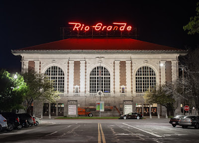
7.  Rio Grande Depot/Rail Undergrounding Proposal.  I went to a presentation a few days ago about a citizen plan to recenter train service on the historic Rio Grande Station.  

Flickr photo by Terry Redeker.

The railroad tracks were relocated a couple blocks behind the station around 2000. to a pretty gnarly set of platforms and a intermodal transit facility that doesn't have the grandeur or centrality of the rail station.

It's a pretty interesting idea, and would require relocating the railroad tracks underground and the light rail tracks closer.  It would repattern the land use significantly, allowing for significant build out opportunity of more than 50 acres.  

It could also refocus attention on transit as a legitimate mode, and recenter Salt Lake City's competitive advantages in part around transit.

-- Rio Grande Plan

I will be writing about this separately.

Flickr photo by Peter Ehrlich.

8.  Mayors initiative to extend passenger rail service to Boise and Las Vegas.  UTA has a decent commuter line, from Provo to Ogden, called the Frontrunner.  Ideally, it would be extended in both directions, to Southern Utah, and north to Logan.

Last year, the mayors of Salt Lake and Boise came together on an initiative to reconnect the cities by railroad ("A Utah train to Idaho? Salt Lake, Boise leaders are working to restore old service," KSL-TV; "Train corridors proposed connecting Boise, Las Vegas to Salt Lake City," Fox13).  Similarly, service could be extended to Las Vegas, where it could then connect to Los Angeles.

How they see the service being restored, although there should be a stub line to Logan, Utah, home to Utah State University.

In one way, it would merely restore services that once existed, service from Los Angeles to Salt Lake via Las Vegas, and service from Salt Lake to Idaho, Portland, and Washington.  Those trains were cancelled in 1999.

It should be pursued as a next step in the Rio Grande Plan.  And is basically along the lines of how I argue rail transit service should be organized in the US ("Two train/regional transit ideas: Part 1 | Amtrak should acquire Greyhound") modeled after Japan.

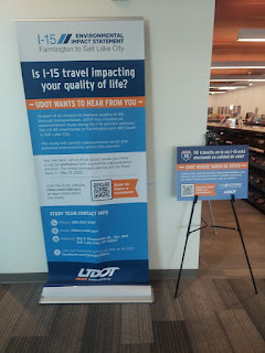
10.  Not transit per se, but the Utah Department of Transportation wants to widen I-15 through Salt Lake City ("UDOT unveils details on new $1.6B widening of I-15 through SLC," Building Salt Lake). 

-- UDOT releases transportation alternatives for I-15 from Farmington to Salt Lake City

 Given that Frontrunner parallels it, it's an impressive example of the failure to undertake multimodal corridor management.  As David Engwicht, the creator of the concept of transportation demand management realized, if you reduce the number of motor vehicles, you don't have to widen roads.

This piece has links to past entries concerning corridor management.

-- "Washington Post letter to the editor on repair-related closure of Rockville and Shady Grove Stations and corridor management" (2021)

Labels: , , , , , , ,

Tuesday, August 23, 2022

Boston Orange Line closure and responses including promoting biking

When various segments of Metrorail lines are shut down for months in the DC Metropolitan area for rehabilitation, I've suggested that a "corridor management" approach should be taken, and alternative modes promoted, like commuter rail and bus ("Transportation network interruptions as an opportunity: Part 2," 2016, "Washington Post letter to the editor on repair-related closure of Rockville and Shady Grove Stations and corridor management," 2021).  Too often that hasn't been done.

The Safetrack signage was kind of "half-a@#$%."

I do remember early on though when Metrorail promoted using bikes instead, with the addition of various yard signs with routing information.  

The signage promoted the "Safetrack" detour.  But there wasn't an active companion program helping people with the switch.

The Orange Line is a heavy rail line serving Boston and the inner ring suburbs of Malden, Medford and Somerville. Pre-covid it had more than 200,000 daily riders.

It's shut down for a month for repair.  Note that property interests are concerned about the decline in transit quality generally as a potential hindrance to their getting tenants ("The Orange Line shutdown puts developers building by the T in a tricky spot," Boston Globe).

-- Boston Mayor Michelle Wu said with the closure, other transit options should be free.  Some are, including shuttle buses.

-- MBTA produced a good guide on options, A Rider’s Guide to Planning Ahead: Upcoming Orange & Green Line Service Suspensions August – September 2022.

-- The City has a nice website laying out options, Orange Line Shutdown in Boston, with more detailed information for different rider groups like students, seniors and the disabled, etc.

-- One of the options are free passes to use the bike sharing system during the shutdown ("MassDOT Releases Bicyclist Guide Ahead of Orange Line Closure Beginning August 19")

-- The MBTA is allowing people with Charlie Card transit fare media cards to ride rail commuter lines for free ("MBTA Releases Travel Plan for Orange, Green Line Shutdowns: Read It Here," NBC10), although I don't know if that adequately serves the people left without the Orange Line.

Fortunately, the Haverhill MBTA Commuter rail line parallels the Orange Line and terminates at North Station.

-- The Globe has an article ("In Orange Line closure, bicyclists see silver lining") about the response by the Boston Cyclists Union.  And yes, these kinds of closures should really be seen as opportunities to promote biking.  From the article:

... The city’s cycling community sees the situation as the perfect opportunity to introduce, or reintroduce, people to biking and bike commuting.

That’s why the Boston Cyclists Union members were at Forest Hill station on Sunday morning. The group offered free tune-ups before leading a group on a practice commute along the Southwest Corridor and Columbus Avenue to downtown.

Under a pop-up tent, a cyclists union mechanic showed a rider how to adjust his brakes and check for bent spokes. On the other side of the tent, another cyclists union volunteer helped figure out what parts were needed to reattach a front wheel. About 30 people turned out in total.

The cyclists’ union has been in conversation daily with City Hall and the Massachusetts Department of Transportation about the closure, said Eliza Parad, the group’s director of organizing.

The additional traffic, shuttle buses, and the ever-present potholes could still be dangerous, especially on Columbus Avenue where cyclists must share the road with cars, Parad said. ...

Mayor Michelle Wu, a frequent Orange Line rider, has been publicly promoting bike commuting in recent days. She led two group cycle commutes from her Roslindale neighborhood to City Hall last week.

Patrick Snyder, 23, hopes the closure will lead to more bike safety infrastructure. He was injured in a bicycle crash in April 2021 in the Boston area and only started biking again after a stint in the cycle-friendly Netherlands. Now he will be among several Boston Cyclists Union members leading group commutes on weekday mornings from various locations along the Orange Line.

The Cyclist Union effort is a good one. 

But a lot more needs to be done than merely saying: ride a bike.

There need to be routes, secure bike parking, and opportunities to test out biking by borrowing a bike, lock, and helmet without having to buy them first.

-- "Revisiting assistance programs to get people biking: 18 programs," 2020
-- "May is National Bike Month too: Part 1 -- a good time to assess planning and programming," 2021
-- "World Bicycle Day is today: Ideas for making transportation cycling irresistible," 2021

That being said the various steps that MBTA, the City, the Cyclists Union, and other organizations have taken are quite remarkable compared to what I remember from the various rail shutdowns in the DC area.  The bicyclist guide, the Rider Guide by MBTA are quite good.

====

WRT developers concerned about the decline in transit quality as a hindrance, maybe that can get anti-transit developers like Larry Hogan of Maryland on board.  But I doubt it.  Note that Massachusetts has a tradition of Republican governors over the last 20 years, and they haven't ignored transit.  They haven't always done the right things.  But it hasn't been ignored.

That isn't the case in many other places.

Labels: , , , , , ,

Monday, October 25, 2021

Update: Montgomery County I-270 Corridor Transit Plan | Was: Washington Post letter to the editor on repair-related closure of Rockville and Shady Grove Stations and corridor management

The original entry, published on Monday October 11th, called for "corridor management" in Western Montgomery County, centered on I-270, the western leg of the Metrorail Red Line, the MARC Brunswick Line, and related major roads there.  In part it was an update of a series of pieces from 2016.

Unbeknownst to me, I guess after the debacle in 2016, and maybe in part because of my writings, the Montgomery County Planning Department embarked on the creation of a "corridor management" plan for that area, which has just been released, and which the Washington Post reported, "I-270 corridor needs bus lanes, Metro extension to improve transit, Montgomery planners say."

-- Corridor Forward: The I-270 Transit Plan, Planning Department, Montgomery County, Maryland

Technically, it's a transit plan for I-270, not a broader "corridor management" plan the way that I outlined originally.  Arguably it might be more ambitious (a bit more ambitious on transit, less ambitious on corridor management).  

Bus rapid transit.  The big things recommended and most achievable in the near term are expanded bus rapid transit including the construction of the Corridor Cities Transitway, something that's been in planning for decades. 

Railroad.  The plan recommends bi-directional service on the MARC Brunswick Line with mid-day frequency of one hour, and 15-minute headways in the morning and evenings and new stations at Shady Grove and White Flint (this was mentioned in my Purple Line series).  

While this was recommended in an older MARC Plan, after the 2008 recession, this initiative has fallen by the wayside.  That MoCo makes it a part of their local master plan means it becomes harder for the State of Maryland to blow it off.

Although the recommendations don't call for integration between local transit and railroad service comparable to the London Overground ("One big idea: Getting MARC and Metrorail to integrate fares, stations, and marketing systems, using London Overground as an example").  

Metrorail extension to Germantown.  One thing the plan calls for that I didn't, is the extension of the Red Line to Germantown, adding two stations to Gaithersburg and a terminal station in Germantown.  

The Red Line in this graphic shows the proposed extension of the western leg of the Metrorail in Montgomery County.

This is a big deal.  I didn't make such a suggestion because this series was more focused on intermediate term achievable changes, while a Red Line extension will take decades.

Germantown is Montgomery County's largest conurbation without frequent rail transit service.

(FWIW, in 2006 in a presentation to the Action Committee for Transit, I suggested such an extension.)

Purple Line extension to Tysons.  It calls for more detailed study of a Purple Line extension westward from Bethesda to Tysons, which the car-focused Maryland Department of Transportation hasn't supported.  Again, by putting it the local master plan, it becomes less ignorable by the state.

The proposed light rail connection from Frederick to Metrorail is shown as a blue line on this map.

Light rail extension to Frederick from Shady Grove.  The plan also suggests a light rail extension to Frederick, making the point that the Hogan Administration's embrace of a monorail proposal ("The real problem with the I-270/HOT Lanes proposal is that they've already come up with the solution: HOT Lanes," 2019) is impractical given the cost and expected ridership.  

Similarly, given the land use context which is less densely developed and populated, it doesn't make sense to extend Metrorail--heavy rail transit--from Germantown to Frederick.  Light rail could be a good compromise.

This graphic shows the multiple rail transit services in San Diego County, with Oceanside being a key hub.  Wikipedia image.

The light rail concept is not dissimilar from how North San Diego County has a rail line from the Oceanside railroad station.  Or light rail in New Jersey, in Hudson County across the river from New York City, and the River Line from Trenton to Camden, in the Philadelphia region.  But the recommended 6-minute headway is probably overkill.

Gaps.  But because it is a transit plan, not a corridor management plan, it doesn't suggest some of the other points I made, such as multi-modal corridor management and better coordination with DC, rush hour HOV-2 on surface regional arterials, etc..  Note that I didn't suggest better coordination with Frederick County, which is a must. 

It also doesn't mention growing the inter-city commuter bus program, for which Maryland generally is best practice.

Public comments and support are necessary to move these recommendations from ideas to implementation.  There will be public comment opportunities for this planning document, before it is forwarded to the Montgomery County Council for adoption.  People should review the plan and submit comments.

The Metrorail extension to Germantown, a proposed light rail link to Frederick, and extension of the Purple Line to Tysons all need a great deal of public support to move up to become actual priorities in the regional transportation capital improvements plan and budget.

Similarly, support of bi-directional service on the MARC Brunswick Line requires a great deal of public support for the State of Maryland to adopt this recommendation and add it to the regional transportation capital improvements plan also.

And making more general points about the need for corridor management involving DC and Frederick County, as well as Northern Virginia, for integration of MARC and the SmarTrip transit system, and for the consideration of cheaper pricing for MARC trips within Montgomery County

================

Recommendations from the Original Piece

Cars

1.  Figure out how to impose and collect a daily parking tax on office parking lots and structures in Montgomery County, especially for "free parking."  From the paper "THE EFFECT OF FREE PARKING ON COMMUTER MODE CHOICE: EVIDENCE FROM TRAVEL DIARY DATA":

The mode choice model predicts that with free parking, 62 percent of commuters will drive alone, 16 percent will commute in carpools and 22 percent will ride transit; with a daily parking charge of $6, 46 percent will drive alone, 4 percent will ride in carpools and 50 percent will ride transit. The mode choice model predicts that a daily parking charge of $6 in the Portland CBD would result in 21 fewer cars driven for every 100 commuters.

2.  With great ride-matching/car pooling support, for both individuals and van pool programs like vRide.

3.  Implement HOV-2 on major roads within I-270's "car shed" during rush hours.

4.  HOT Lane implementation on I-270 and I-495 should be required to include transit expansion (items #11 and #14 below). 

Bicycle

5. Support long(er) distance bicycle commuting through focused initiatives, especially with e-bikes. (By this I mean maybe an e-bike means someone willing to ride 2 miles on a pedal bike would ride 5 miles with an e-bike.  Etc.)

Passenger rail services

6.  Expand MARC passenger rail service on the Brunswick Line, in both directions throughout the day.

7.  I also argue that a MARC Line could be built as part of I-270, continuing to Bethesda, Georgetown, and Arlington County, Virginia.

8.  Market rail passenger service integrated with Metrorail comparable to the London Overground program. 

9.  Add an in-city station at Fort Totten as a way to provide extra-connection to the subway network outside of Union Station--Fort Totten is a transfer station for the Green and Yellow Lines, which would also provide redundancy to the network if Union Station were not operative for any reason.

10.  Build the proposed North Bethesda district MARC infill station.

Bus transit

11.  Develop more commuter bus solutions for the I-270 corridor.  For example, imagine if as part of the HOT Lane program ("County officials say Maryland governor made ‘empty’ threats to get toll lanes plan approved," Washington Post), an exclusive bus lane was also included.

Separated express bus lanes in Brisbane, Australia

This should include cross-border services on Wisconsin and Connecticut Avenues between DC and Maryland.  Currently, Maryland DOT is resistant to funding cross-border bus services in these corridors, instead focusing on in-state exclusive services.   

12. Make implementing the element of the Montgomery County bus rapid transit program targeting the I-270 corridor the top priority in the launch of the program.

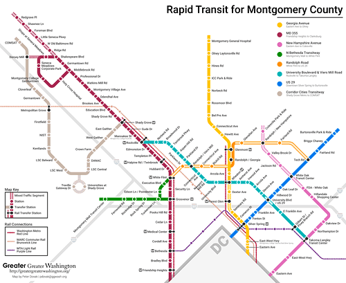
Map of the proposed MoCo BRT program by Peter Dovak for Greater Greater Washington (blog post).

Purple Line light rail

13.  Instead of calling for another freeway crossing between Maryland and Virginia (and maybe one is needed), begin planning for the extension of the Purple Line west to Tysons/Fairfax County in association with future necessary reconstruction of the American Legion Memorial Bridge.
Purple Line Map  DC Metro
Purple Line full concept, from the Sierra Club Metro DC Sprawl campaign.

American Legion Memorial Bridge, WAMU/NPR photo.

14.  Only with the commitment to planning for Purple Line extension west should the State of Maryland consider the pursuit of HOT lanes on I-270, which does improve congestion, but generates more SOV trips, not fewer.  Still, connecting such lanes to similar infrastructure in Virginia, especially the HOT lanes on I-495, makes sense.

Labels: , , , , , , ,

Monday, October 11, 2021

Washington Post letter to the editor on repair-related closure of Rockville and Shady Grove Stations and corridor management
The Washington Post has a letter, "Metro’s closure of two Montgomery County Red Line stations was a bad decision," complaining that it's inopportune that WMATA has closed two upper Montgomery County stations for repairs.  

In 2019, Rockville had an average of 3,900 daily riders and Shady Grove, being an end of line station, had 11,300 daily riders (this tends to result from riders living further out).  (There is also a MARC train stop at Rockville and a Rockville Metro Station Visioning and Concept Design Study is underway.)

It's not a "bad decision," nor particularly noteworthy, as WMATA has been temporarily closing stations across the system for months at a time as part of a multi-year program of system rehabilitation (WMATA Capital Improvement Program website, Rockville canopy project).  

As a commenter wrote, where was the concern of the writer when other stations across the system were closed?

The need for multi-modal transportation corridor management.  But the letter does remind me of a point I made in 2016, when Beach Drive in DC was closed for many months for rebuilding, while at the same time so were Metrorail stations on the eastern leg, while in DC interrupted the trip of MoCo residents using the subway, that in the "I-270 corridor," area transportation officials and planners should conceptualize their approach to such decision making in terms of "multi-modal corridor management" and work towards minimizing disruption.

-- "Transportation infrastructure interruptions as a missed opportunity for improving transportation demand management programming"
-- "Transportation network interruptions as an opportunity: Part 2"
-- ""Transportation network service interruptions part 3: corridor/commute shed management for Northwest DC and Montgomery County, Maryland"

In this corridor you have the north-south routes between DC and Maryland of I-270, Rockville Pike/Wisconsin Avenue, Connecticut Avenue, the western leg of Metrorail's Red Line, and the MARC Brunswick Line in Maryland, and Wisconsin Avenue, Connecticut Avenue, Beach Drive, and Georgia Avenue in DC (and Maryland), along with bus services.  Plus east-west I-495, the Beltway, and connections to and from Virginia. Which in theory should be managed in a coordinated fashion.

For the most part, each mode, each agency, does its own thing.  Yes there is a modicum of coordination, but the opportunity to do significant mitigation and integration between transit systems is minimal.

Another reason for implementing German style transport associations in the US/the DC area.  This is an other example of how a metropolitan area "transport association" using the German model ("The answer is: Create a single multi-state/regional multi-modal transit planning, management, and operations authority association") would, theoretically, lead to better coordination and service.  

But in my writings on porting the German style VV to the US, I didn't consider that area highway agencies need to participate as well.   

Anyway, the major point I made then was that if the MARC Brunswick Line were bi-directional, and when necessary because of Metrorail closures, more frequent -- more the equivalent of the German S-Bahn or London Overground in terms of service frequency and integration with heavy rail transit -- closures of one could be addressed by riding the other ("One big idea: Getting MARC and Metrorail to integrate fares, stations, and marketing systems, using London Overground as an example," 2015).

Conclusion.  Were the Brunswick Line bi-directional, and you'd think 5 years would have been enough time to make it so, the temporary closure of the Rockville and Shady Grove stations wouldn't be a particular hardship.

The recommendations from 2016 are just as relevant today (combined, reordered and revised):

Cars

1.  Figure out how to impose and collect a daily parking tax on office parking lots and structures in Montgomery County, especially for "free parking."  From the paper "THE EFFECT OF FREE PARKING ON COMMUTER MODE CHOICE: EVIDENCE FROM TRAVEL DIARY DATA":

The mode choice model predicts that with free parking, 62 percent of commuters will drive alone, 16 percent will commute in carpools and 22 percent will ride transit; with a daily parking charge of $6, 46 percent will drive alone, 4 percent will ride in carpools and 50 percent will ride transit. The mode choice model predicts that a daily parking charge of $6 in the Portland CBD would result in 21 fewer cars driven for every 100 commuters.

2.  With great ride-matching/car pooling support, for both individuals and van pool programs like vRide.

3.  Implement HOV-2 on major roads within I-270's "car shed" during rush hours.

4.  HOT Lane implementation on I-270 and I-495 should be required to include transit expansion (items #11 and #14 below). 

Bicycle

5. Support long(er) distance bicycle commuting through focused initiatives, especially with e-bikes. (By this I mean maybe an e-bike means someone willing to ride 2 miles on a pedal bike would ride 5 miles with an e-bike.  Etc.)

Passenger rail services

6.  Expand MARC passenger rail service on the Brunswick Line, in both directions throughout the day.

7.  I also argue that a MARC Line could be built as part of I-270, continuing to Bethesda, Georgetown, and Arlington County, Virginia.

8.  Market rail passenger service integrated with Metrorail comparable to the London Overground program. 

9.  Add an in-city station at Fort Totten as a way to provide extra-connection to the subway network outside of Union Station--Fort Totten is a transfer station for the Green and Yellow Lines, which would also provide redundancy to the network if Union Station were not operative for any reason.

10.  Build the proposed North Bethesda district MARC infill station.

Bus transit

11.  Develop more commuter bus solutions for the I-270 corridor.  For example, imagine if as part of the HOT Lane program ("County officials say Maryland governor made ‘empty’ threats to get toll lanes plan approved," Washington Post), an exclusive bus lane was also included.

Separated express bus lanes in Brisbane, Australia

This should include cross-border services on Wisconsin and Connecticut Avenues between DC and Maryland.  Currently, Maryland DOT is resistant to funding cross-border bus services in these corridors, instead focusing on in-state exclusive services.   

12. Make implementing the element of the Montgomery County bus rapid transit program targeting the I-270 corridor the top priority in the launch of the program.

Map of the proposed MoCo BRT program by Peter Dovak for Greater Greater Washington (blog post).

Purple Line light rail

13.  Instead of calling for another freeway crossing between Maryland and Virginia (and maybe one is needed), begin planning for the extension of the Purple Line west to Tysons/Fairfax County in association with future necessary reconstruction of the American Legion Memorial Bridge.
Purple Line Map  DC Metro
Purple Line full concept, from the Sierra Club Metro DC Sprawl campaign.

American Legion Memorial Bridge, WAMU/NPR photo.

14.  Only with the commitment to planning for Purple Line extension west should the State of Maryland consider the pursuit of HOT lanes on I-270, which does improve congestion, but generates more SOV trips, not fewer.  Still, connecting such lanes to similar infrastructure in Virginia, especially the HOT lanes on I-495, makes sense.

Labels: , , , , , ,

Wednesday, January 23, 2019

More on the origin story for Portland transit/+ current proposal for tolls on I-5

Portland Oregon is the poster child for sustainable transportation, known for demolishing a waterfront freeway, focusing serving the downtown by transit, later creating light rail and streetcar programs, supporting bicycle use, etc.

It's frustrating as a planner when people bring up Portland as an example, because what they usually don't understand Portland's "secret," which is that what they see today is built on almost 50 years of tough, visionary, bold decision making. (1) not only did they make a visionary decision to move away from freeways; (2) they realized they needed to focus development downtown; (3) and instead of prioritizing the car, they prioritized transit service--first bus, then light rail, and then streetcar; and (4) they continued to build on these decisions "incrementally" with what we might call "continuous process improvement."

-- "A summary of my impressions of Portland, Oregon and planning," 2005
-- "Nohad Toulan: The University in the City," Portland State University, 2014
-- "Portland Oregonian says that Seattle is now far more innovative concerning sustainable mobility than Portland," 2018
-- "Light rail: blight or bliss"," Vancouver Columbian, 2013

In short, they were bold and they continued to be bold, through decisions that build on and extended the previous decisions. It's a perfect example of what I call "Transformational Projects Action Planning," although it was more incremental and somewhat unintentionally a process where the sum of the parts ended up being even stronger than the individual pathbreaking efforts.

-- "Why can't the "Bilbao Effect" be reproduced? | Bilbao as an example of Transformational Projects Action Planning," 2017
-- "Downtown Edmonton cultural facilities development as an example of "Transformational Projects Action Planning" 2018

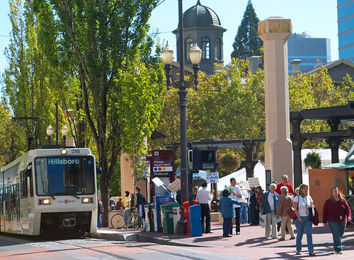
Pioneer Square, Max Light Rail, Protestors, at Lunchtime.jpg
Pioneer Square, Max Light Rail, Protestors, at Lunchtime.  Photo from the now sadly defunct website PortlandGround.

An article on a proposal for tolls on I-5 in Greater Portland, which links Oregon and Washington, includes a link to a 2014 piece from Willamette Week, the alternative newsweekly for Portland, with more back story on how light rail came about, "Feb. 4, 1974: Portland kills the Mount Hood Freeway..."

Neal Goldschmitt, the mayor who "killed the freeway," started out as a legal aid lawyer who saw the city's plans for a bunch of freeways to be not only a bad thing but a hook for running for office. He got elected to City Council in 1970 and as Mayor in 1972. (The Downtown Plan discussed in the 2005 entry was passed in 1972.)

Goldschmitt didn't want to lose the money allocated for "highways" and proposed a system of dedicated "bus roads," but was convinced to push for light rail instead, which originally was opposed by the area Growth Machine, including the local newspaper.

But he was successful, and the rest, as they say, is history.

========
Tolling and I-5

The FreightWaves article, "Oregon Toll Proposal Pits Trucks Against Transit," is important because it shows how flawed transportation capacity planning usually is, because of the various political and economic interests, and the failure to employ more objective "transportation demand management" approaches, and other problems.

I-5 in Portland.  Photo: Portland Tribune, "City Council supports tolling to ease highway traffic."

For example, I-5 is used as a major commuting artery between Washington State and Portland, and the backbone of freight transportation along the West Coast, but expanding light rail to Vancouver hasn't been successful, although it would capture a fair amount of car traffic, thereby "adding capacity" for freight and other uses.

Note that the Tri-Met Yellow Line ("Interstate"), was originally intended to terminate in Vancouver, but the political complexity added to the project by attempting to serve two states led the transit agency to drop the Washington State connection in order to start building the project.

Currently, Oregon laws as currently written only allow toll revenues to be used for road projects, not transit and sustainable transportation. And the various trucking lobbies want the funds to be used solely for adding lanes.

From the article:
Truckers support tolls that would increase efficiencies and offset the cost of congestion, said Jana Jarvis, the head of the Oregon Trucking Associations (OTA). "But," said Jarvis, who represented trucking interests on a committee studying the tolling, "we want additional lanes, additional road capacity."

The Washington Trucking Associations referred FreightWaves to Vanderpol for comment. He echoed OTA's position. "We are supportive of tolls if they create new road capacity."

That contingency doesn't sit well with the Street Trust, a Portland-based bike, pedestrian and transit advocacy group. The FHA's approval called for the state to study a hugely complex set of issues, including how tolling revenue will be spent, and what impact it will have on neighborhood traffic and low- income residents, noted Richa Poudyal, the Street Trust's advocacy director.

"In this next phase we advocate for [toll] revenue to be allocated for transit improvements rather than highway projects," Poudyal said. "If the proposal doesn't address those considerations, or if the revenue is only used for highways, we won't support it."

Labels: , , , , ,

Tuesday, April 17, 2018

Maryland HOT lane study versus "corridor management" and regional scaled transportation planning

The Maryland Transit Opportunities Coalition sent out a press release about problems they see with Maryland's study for the addition of high occupancy toll lanes to I-270 and I-495. The first round of public meetings starts tonight:

Tuesday, April 17 at 6:30 p.m. to 8:30 p.m.
Dr. Henry Wise Jr. High School
12650 Brook Lane
Upper Marlboro, MD 20772

Wednesday, April 18 at 6:30 p.m. to 8:30 p.m.
Clarksburg High School
22500 Wims Road
Clarksburg, MD 20871

Thursday, April 19 at 6:30 p.m. to 8:30 p.m.
Bethesda Chevy Chase High School
4301 East West Highway
Bethesda, MD 20814

Tuesday, April 24 at 6:30 p.m. to 8:30 p.m.
Eleanor Roosevelt High School
7601 Hanover Parkway
Greenbelt, MD 20770

They prefer a more balanced set of responses, including more investment in transit, while this particular transportation planning initiative is solely road focused.  The proposal is to add lanes exclusively for people willing to pay tolls, on the Capital Beltway (I-495) and on I-270.  These lanes would link up to comparable infrastructure in Virginia. 

MTOC makes the point that given the experience with tolls on newly tolled I-66, where sometimes tolls are greater than $41 ("A quick comment on I-66 Tolling"), the impact of this addition would be limited mostly to high income households.

The program is being driven by interest in the private sector ("Public gets chance to weigh in on Md. toll lane plans," WTOP; "Speedy selection process ends with Maryland official’s former firm being chosen for project," Washington Post).  Still they have been in state highway plans since 2005.

-- Maryland’s Statewide Express Toll Lanes Network Initiative

Last week I was riding up Georgia Avenue in Montgomery County in the late afternoon and the traffic was backed up for one mile or more northbound to the I-495 entry ramps.

It made me think that it would be worthwhile to connect the Maryland initiative with ideas I've suggested over the years to create a system of tolled "commuter road tunnels" under major thoroughfares within DC, to mitigate the traffic impact on the abutting neighborhoods, but also speeding up traffic and maintaining the relevance of DC's central business district as a regional center for commerce and employment.

Two pieces discuss "underground toll commuter routes"  ("Tunnelized road projects for DC and the Carmel Tunnel, Haifa, Israel example--tolls" and "London Mayor proposes roadway tunnels to divert surface motor vehicle traffic and congestion") on routes such as North Capitol Street-Blair Road, 16th Street, and New York Avenue, and these pieces cover the idea of  "corridor management" in the I-270 corridor, but in terms of continuing on to DC ("Transportation network interruptions as an opportunity: Part 2 and "Transportation network service interruptions part 3: corridor/commute shed management for Northwest DC and Montgomery County, Maryland).

Given the traffic I witnessed on Georgia Avenue, that street and maybe Connecticut Avenue ought to be included in such a network. 

But while previously my suggesting about a Blair Road-North Capitol tunnel (ironically comparable to the originally suggested "North Central Expressway" in highway planning dating to the 1960s) would have ended the route at Georgia Avenue, obviously such a route should continue on into Maryland for some distance.  Same with Connecticut Avenue and 16th Street.

Ideally, were we to have a true regional transportation planning system, you could integrate this kind of road planning between DC and Maryland because this initiative might be the only way to bring such a complete network about, while also considering transit expansion both in terms of bi-directional railroad service between DC and Frederick Maryland (item #4 in this piece) and between Bethesda and the Tysons District of Fairfax County via I-495.

While not exactly comparable, Orange County and Riverside County in California have cooperated to extend the SR-91 Toll Road into Riverside County ("91 Express Lanes in Orange County paved way for new toll lanes opening Monday in Riverside," Orange County Register).

======
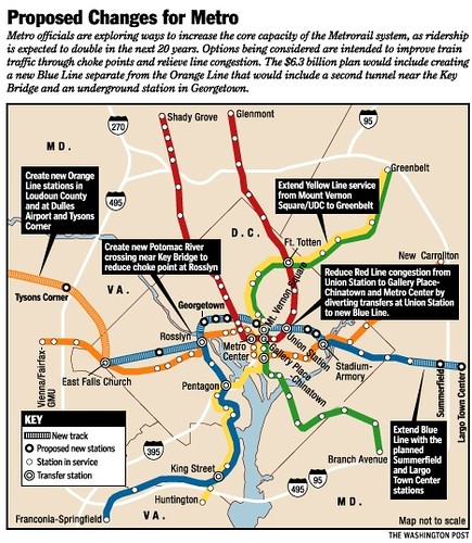
Besides the development of three different bus rapid transit programs in the metropolitan area, the comparable planning failure I'm thinking about would be DC's failure to take advantage of Virginia's Silver Line Metrorail expansion as a way to bootstrap its continuation into DC, as the old proposed "separated blue line."  I first wrote about that in 2006 ("Blinking on urban design means you limit your chance for success").

Graphic published in the Washington Post in 2001, outlining WMATA's plan for a separated blue line
Proposed changes for the WMATA system, 2001 (separated blue line)

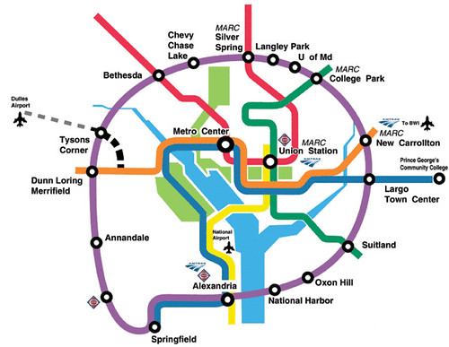
Paul Meissner/Richard Layman concept for an expanded Metrorail system including a separated Silver Line in place of the original separated blue line proposal
Conceptual Future integrated rail transit service network for the Washington DC National Capitol Region. Design by Paul J. Meissner.  Concept by Richard Layman and Paul Meissner.


Labels: , , , ,

Thursday, December 07, 2017

A quick comment on I-66 tolling

-- Transform 66 in Northern Virginia


This week, rush hour tolling has been introduced to I-66, the east-west Virginia interstate that provides access to DC. 

In advance of the launch, there has been a fair amount of communication about it, including full-page ads in the Washington Post and in other media (don't recall seeing tv ads, but then since the November 2016 election, I don't watch tv news very much), and media coverage ("Interstate 66 tolling starts Monday. Here's what you need to know," Washington Post).

I've written about this in the context of corridor management planning ("Transportation network interruptions as an opportunity: Part 2") and indirectly in terms of conceptualizing a broad plan of improvement of the Northern Virginia transit network in the context of the Silver Line extension ("Using the Silver Line as the priming event, what would a transit network improvement program look like for NoVA?").

As an occasional driver, of course I prefer to not have to pay tolls, but as a planner, I recognize why you want to charge tolls, not only to raise the monies necessary to pay for transportation infrastructure, but also to provide better "cues" to encourage more optimal choices in the context of supply, demand, and infrastructure supply constraints.

Transportation is one of those areas where consumers and elected officials especially want to believe that it has nothing to do with economics. 

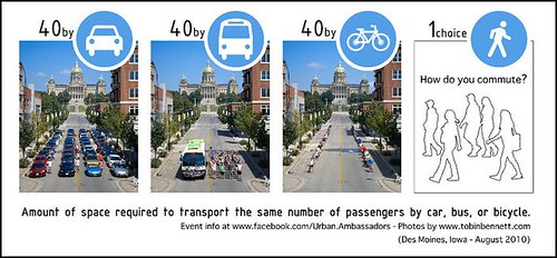
The reality is that the failure to apply economic decision-making to transportation creates "market failures" a/k/a "congestion," although this is abetted by what I call transportation physics and the difference between personal mobility and mass transit--the latter uses space much more efficiently.

One 40-foot bus transports as many people as are usually carried in about 60 cars.
Amount of space required to transport the user the same number of passengers by car, bus, or bicycle

The thing about the I-66 toll program is that it contravenes the typical experience across the US in terms of having specific toll roads, especially HOT -- High Occupancy Toll -- lanes.

Other than HOT lanes, the DC metropolitan area has two toll roads in Northern Virginia (Dulles Toll Road, Dulles Greenway, and people aren't particularly enamored with them, and many users lack alternatives. (Elsewhere in Maryland and Virginia there are various bridge and tunnels that are tolled, and other tolled roads, including a stretch of I-95 towards the Maryland-Delaware border.)

Typically, HOT lanes add capacity but restrict access to those willing to pay the price to use the lanes, while still providing access to lanes that aren't tolled. The idea is that the toll is variable, designed to maintain the flow of high speed traffic. As capacity is absorbed by toll payers, the toll rises in order to discourage people from using the lanes, in order to maintain a relatively high speed.

On day one of new tolls along I-66 inside the Capital Beltway, climbed over $30. (WTOP/Dave Dildine, "I-66 afternoon tolls moderate after ‘unfair’ $40 morning high."

The I-66 tolling project hasn't added any capacity.  Heretofore, rush hour access to I-66 has been limited to vehicles with two or more occupants (with exceptions for hybrid vehicles and people traveling to Dulles Airport), and the entire freeway was treated as "High Occupancy Vehicle" lanes.

The toll project has removed the HOV restriction.  Now, previously non-qualified drivers -- single occupant vehicles -- can use the road during rush periods, if they pay.  HOV-2 users can still drive for free, and hybrid vehicles no longer have an HOV-exception.

What the tolling project does is increase demand to use the road, with no increase in lane capacity.  Normally, HOT lanes add capacity in return for restricting access to people willing to pay for it.

Looking west on Lee Highway, lines of cars split between taking I-66 vs. staying on Lee Highway What the project during rush hour Monday. (Jahi Chikwendiu/The Washington Post).

So yes, compared to other toll lanes in the area, tolls on I-66 are likely to be "outlandish" ("Day 3 I-66 toll hits $23. Are commuters finding alternatives?" and "I-66 express lanes debut with $34.50 toll, among the highest in the U.S.," Washington Post) because now more cars will be competing for the same amount of road space.

And as Charlie points out in a comment, it communicates a major problem with "Public Private Partnerships," in that they are contractual and the operator is typically uninterested in being flexible. 

Furthermore, concessionaires are somewhat insulated from bad press even if they get it, because they have contracts that are pretty much impregnable.

Although it can come back to haunt the elected officials who approved the contracts.

The I-66 project is even trickier because at one level, the State of Virginia wants to encourage business to locate in Virginia instead of DC, so the outlandish pricing is a "feature, not a bug" to encourage businesses to leave DC so that their employees "don't have to" drive the toll road.

At the same time, there aren't transit improvements, at least in the short and intermediate term, such as those suggested in the Meissner-Layman idealized transit network map--extending the Orange Line west, creating a separated Silver Line, adding a new "Pink Line"--giving people alternatives, and increasing "transportation infrastructure supply" in significant ways.

Conceptual Future integrated rail transit service network for the Washington DC National Capitol Region. Design by Paul J. Meissner.  Concept by Richard Layman and Paul Meissner.

In fact, were Virginia to extend the Orange Line west, they'd have to pay penalties to the concessionaire.

However, what I would have done, were I the concessionaire, is have had a "free" one- or two-week introductory period with the toll pricing being communicated in real-time, so people would have a much better sense for how much the tolls were going to be.

Even so, it's not going to help DC, and DC has no ability to influence the process.  By contrast, in California, most toll roads are run by the counties or Joint Powers Authorities that are cross-jurisdictional.

And the separate programs for each of the "states" -- DC, Maryland, and Virginia -- don't seem to be too well coordinated. 

Orange and Riverside Counties in California offer a significant contrast, where they jointly manage the the SR-91 toll corridor--a corridor management plan. The toll road started out as an exclusive Orange County project, but have ben extended by Riverside County for 8 miles, to better manage the road resource and add capacity ("91 Express Lanes in Orange County paved way for new toll lanes opening Monday in Riverside Orange County Register). The counties as operators coordinate management, tolling, collections, etc.

Such integration and coordination seems a foreign concept here. Cf. "The answer is: Create a single multi-state/regional multi-modal transit planning, management, and operations authority association"

Labels: , , , ,