Rebuilding Place in the Urban Space

"A community’s physical form, rather than its land uses, is its most intrinsic and enduring characteristic." [Katz, EPA] This blog focuses on place and placemaking and all that makes it work--historic preservation, urban design, transportation, asset-based community development, arts & cultural development, commercial district revitalization, tourism & destination development, and quality of life advocacy--along with doses of civic engagement and good governance watchdogging.

Tuesday, August 23, 2022

Boston Orange Line closure and responses including promoting biking

When various segments of Metrorail lines are shut down for months in the DC Metropolitan area for rehabilitation, I've suggested that a "corridor management" approach should be taken, and alternative modes promoted, like commuter rail and bus ("Transportation network interruptions as an opportunity: Part 2," 2016, "Washington Post letter to the editor on repair-related closure of Rockville and Shady Grove Stations and corridor management," 2021).  Too often that hasn't been done.

The Safetrack signage was kind of "half-a@#$%."

I do remember early on though when Metrorail promoted using bikes instead, with the addition of various yard signs with routing information.  

The signage promoted the "Safetrack" detour.  But there wasn't an active companion program helping people with the switch.

The Orange Line is a heavy rail line serving Boston and the inner ring suburbs of Malden, Medford and Somerville. Pre-covid it had more than 200,000 daily riders.

It's shut down for a month for repair.  Note that property interests are concerned about the decline in transit quality generally as a potential hindrance to their getting tenants ("The Orange Line shutdown puts developers building by the T in a tricky spot," Boston Globe).

-- Boston Mayor Michelle Wu said with the closure, other transit options should be free.  Some are, including shuttle buses.

-- MBTA produced a good guide on options, A Rider’s Guide to Planning Ahead: Upcoming Orange & Green Line Service Suspensions August – September 2022.

-- The City has a nice website laying out options, Orange Line Shutdown in Boston, with more detailed information for different rider groups like students, seniors and the disabled, etc.

-- One of the options are free passes to use the bike sharing system during the shutdown ("MassDOT Releases Bicyclist Guide Ahead of Orange Line Closure Beginning August 19")

-- The MBTA is allowing people with Charlie Card transit fare media cards to ride rail commuter lines for free ("MBTA Releases Travel Plan for Orange, Green Line Shutdowns: Read It Here," NBC10), although I don't know if that adequately serves the people left without the Orange Line.

Fortunately, the Haverhill MBTA Commuter rail line parallels the Orange Line and terminates at North Station.

-- The Globe has an article ("In Orange Line closure, bicyclists see silver lining") about the response by the Boston Cyclists Union.  And yes, these kinds of closures should really be seen as opportunities to promote biking.  From the article:

... The city’s cycling community sees the situation as the perfect opportunity to introduce, or reintroduce, people to biking and bike commuting.

That’s why the Boston Cyclists Union members were at Forest Hill station on Sunday morning. The group offered free tune-ups before leading a group on a practice commute along the Southwest Corridor and Columbus Avenue to downtown.

Under a pop-up tent, a cyclists union mechanic showed a rider how to adjust his brakes and check for bent spokes. On the other side of the tent, another cyclists union volunteer helped figure out what parts were needed to reattach a front wheel. About 30 people turned out in total.

The cyclists’ union has been in conversation daily with City Hall and the Massachusetts Department of Transportation about the closure, said Eliza Parad, the group’s director of organizing.

The additional traffic, shuttle buses, and the ever-present potholes could still be dangerous, especially on Columbus Avenue where cyclists must share the road with cars, Parad said. ...

Mayor Michelle Wu, a frequent Orange Line rider, has been publicly promoting bike commuting in recent days. She led two group cycle commutes from her Roslindale neighborhood to City Hall last week.

Patrick Snyder, 23, hopes the closure will lead to more bike safety infrastructure. He was injured in a bicycle crash in April 2021 in the Boston area and only started biking again after a stint in the cycle-friendly Netherlands. Now he will be among several Boston Cyclists Union members leading group commutes on weekday mornings from various locations along the Orange Line.

The Cyclist Union effort is a good one. 

But a lot more needs to be done than merely saying: ride a bike.

There need to be routes, secure bike parking, and opportunities to test out biking by borrowing a bike, lock, and helmet without having to buy them first.

-- "Revisiting assistance programs to get people biking: 18 programs," 2020
-- "May is National Bike Month too: Part 1 -- a good time to assess planning and programming," 2021
-- "World Bicycle Day is today: Ideas for making transportation cycling irresistible," 2021

That being said the various steps that MBTA, the City, the Cyclists Union, and other organizations have taken are quite remarkable compared to what I remember from the various rail shutdowns in the DC area.  The bicyclist guide, the Rider Guide by MBTA are quite good.

====

WRT developers concerned about the decline in transit quality as a hindrance, maybe that can get anti-transit developers like Larry Hogan of Maryland on board.  But I doubt it.  Note that Massachusetts has a tradition of Republican governors over the last 20 years, and they haven't ignored transit.  They haven't always done the right things.  But it hasn't been ignored.

That isn't the case in many other places.

Labels: , , , , , ,

Monday, October 25, 2021

Update: Montgomery County I-270 Corridor Transit Plan | Was: Washington Post letter to the editor on repair-related closure of Rockville and Shady Grove Stations and corridor management

The original entry, published on Monday October 11th, called for "corridor management" in Western Montgomery County, centered on I-270, the western leg of the Metrorail Red Line, the MARC Brunswick Line, and related major roads there.  In part it was an update of a series of pieces from 2016.

Unbeknownst to me, I guess after the debacle in 2016, and maybe in part because of my writings, the Montgomery County Planning Department embarked on the creation of a "corridor management" plan for that area, which has just been released, and which the Washington Post reported, "I-270 corridor needs bus lanes, Metro extension to improve transit, Montgomery planners say."

-- Corridor Forward: The I-270 Transit Plan, Planning Department, Montgomery County, Maryland

Technically, it's a transit plan for I-270, not a broader "corridor management" plan the way that I outlined originally.  Arguably it might be more ambitious (a bit more ambitious on transit, less ambitious on corridor management).  

Bus rapid transit.  The big things recommended and most achievable in the near term are expanded bus rapid transit including the construction of the Corridor Cities Transitway, something that's been in planning for decades. 

Railroad.  The plan recommends bi-directional service on the MARC Brunswick Line with mid-day frequency of one hour, and 15-minute headways in the morning and evenings and new stations at Shady Grove and White Flint (this was mentioned in my Purple Line series).  

While this was recommended in an older MARC Plan, after the 2008 recession, this initiative has fallen by the wayside.  That MoCo makes it a part of their local master plan means it becomes harder for the State of Maryland to blow it off.

Although the recommendations don't call for integration between local transit and railroad service comparable to the London Overground ("One big idea: Getting MARC and Metrorail to integrate fares, stations, and marketing systems, using London Overground as an example").  

Metrorail extension to Germantown.  One thing the plan calls for that I didn't, is the extension of the Red Line to Germantown, adding two stations to Gaithersburg and a terminal station in Germantown.  

The Red Line in this graphic shows the proposed extension of the western leg of the Metrorail in Montgomery County.

This is a big deal.  I didn't make such a suggestion because this series was more focused on intermediate term achievable changes, while a Red Line extension will take decades.

Germantown is Montgomery County's largest conurbation without frequent rail transit service.

(FWIW, in 2006 in a presentation to the Action Committee for Transit, I suggested such an extension.)

Purple Line extension to Tysons.  It calls for more detailed study of a Purple Line extension westward from Bethesda to Tysons, which the car-focused Maryland Department of Transportation hasn't supported.  Again, by putting it the local master plan, it becomes less ignorable by the state.

The proposed light rail connection from Frederick to Metrorail is shown as a blue line on this map.

Light rail extension to Frederick from Shady Grove.  The plan also suggests a light rail extension to Frederick, making the point that the Hogan Administration's embrace of a monorail proposal ("The real problem with the I-270/HOT Lanes proposal is that they've already come up with the solution: HOT Lanes," 2019) is impractical given the cost and expected ridership.  

Similarly, given the land use context which is less densely developed and populated, it doesn't make sense to extend Metrorail--heavy rail transit--from Germantown to Frederick.  Light rail could be a good compromise.

This graphic shows the multiple rail transit services in San Diego County, with Oceanside being a key hub.  Wikipedia image.

The light rail concept is not dissimilar from how North San Diego County has a rail line from the Oceanside railroad station.  Or light rail in New Jersey, in Hudson County across the river from New York City, and the River Line from Trenton to Camden, in the Philadelphia region.  But the recommended 6-minute headway is probably overkill.

Gaps.  But because it is a transit plan, not a corridor management plan, it doesn't suggest some of the other points I made, such as multi-modal corridor management and better coordination with DC, rush hour HOV-2 on surface regional arterials, etc..  Note that I didn't suggest better coordination with Frederick County, which is a must. 

It also doesn't mention growing the inter-city commuter bus program, for which Maryland generally is best practice.

Public comments and support are necessary to move these recommendations from ideas to implementation.  There will be public comment opportunities for this planning document, before it is forwarded to the Montgomery County Council for adoption.  People should review the plan and submit comments.

The Metrorail extension to Germantown, a proposed light rail link to Frederick, and extension of the Purple Line to Tysons all need a great deal of public support to move up to become actual priorities in the regional transportation capital improvements plan and budget.

Similarly, support of bi-directional service on the MARC Brunswick Line requires a great deal of public support for the State of Maryland to adopt this recommendation and add it to the regional transportation capital improvements plan also.

And making more general points about the need for corridor management involving DC and Frederick County, as well as Northern Virginia, for integration of MARC and the SmarTrip transit system, and for the consideration of cheaper pricing for MARC trips within Montgomery County

================

Recommendations from the Original Piece

Cars

1.  Figure out how to impose and collect a daily parking tax on office parking lots and structures in Montgomery County, especially for "free parking."  From the paper "THE EFFECT OF FREE PARKING ON COMMUTER MODE CHOICE: EVIDENCE FROM TRAVEL DIARY DATA":

The mode choice model predicts that with free parking, 62 percent of commuters will drive alone, 16 percent will commute in carpools and 22 percent will ride transit; with a daily parking charge of $6, 46 percent will drive alone, 4 percent will ride in carpools and 50 percent will ride transit. The mode choice model predicts that a daily parking charge of $6 in the Portland CBD would result in 21 fewer cars driven for every 100 commuters.

2.  With great ride-matching/car pooling support, for both individuals and van pool programs like vRide.

3.  Implement HOV-2 on major roads within I-270's "car shed" during rush hours.

4.  HOT Lane implementation on I-270 and I-495 should be required to include transit expansion (items #11 and #14 below). 

Bicycle

5. Support long(er) distance bicycle commuting through focused initiatives, especially with e-bikes. (By this I mean maybe an e-bike means someone willing to ride 2 miles on a pedal bike would ride 5 miles with an e-bike.  Etc.)

Passenger rail services

6.  Expand MARC passenger rail service on the Brunswick Line, in both directions throughout the day.

7.  I also argue that a MARC Line could be built as part of I-270, continuing to Bethesda, Georgetown, and Arlington County, Virginia.

8.  Market rail passenger service integrated with Metrorail comparable to the London Overground program. 

9.  Add an in-city station at Fort Totten as a way to provide extra-connection to the subway network outside of Union Station--Fort Totten is a transfer station for the Green and Yellow Lines, which would also provide redundancy to the network if Union Station were not operative for any reason.

10.  Build the proposed North Bethesda district MARC infill station.

Bus transit

11.  Develop more commuter bus solutions for the I-270 corridor.  For example, imagine if as part of the HOT Lane program ("County officials say Maryland governor made ‘empty’ threats to get toll lanes plan approved," Washington Post), an exclusive bus lane was also included.

Separated express bus lanes in Brisbane, Australia

This should include cross-border services on Wisconsin and Connecticut Avenues between DC and Maryland.  Currently, Maryland DOT is resistant to funding cross-border bus services in these corridors, instead focusing on in-state exclusive services.   

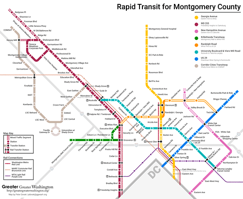
12. Make implementing the element of the Montgomery County bus rapid transit program targeting the I-270 corridor the top priority in the launch of the program.

Map of the proposed MoCo BRT program by Peter Dovak for Greater Greater Washington (blog post).

Purple Line light rail

13.  Instead of calling for another freeway crossing between Maryland and Virginia (and maybe one is needed), begin planning for the extension of the Purple Line west to Tysons/Fairfax County in association with future necessary reconstruction of the American Legion Memorial Bridge.
Purple Line Map  DC Metro
Purple Line full concept, from the Sierra Club Metro DC Sprawl campaign.

American Legion Memorial Bridge, WAMU/NPR photo.

14.  Only with the commitment to planning for Purple Line extension west should the State of Maryland consider the pursuit of HOT lanes on I-270, which does improve congestion, but generates more SOV trips, not fewer.  Still, connecting such lanes to similar infrastructure in Virginia, especially the HOT lanes on I-495, makes sense.

Labels: , , , , , , ,

Monday, October 11, 2021

Washington Post letter to the editor on repair-related closure of Rockville and Shady Grove Stations and corridor management

The Washington Post has a letter, "Metro’s closure of two Montgomery County Red Line stations was a bad decision," complaining that it's inopportune that WMATA has closed two upper Montgomery County stations for repairs.  

In 2019, Rockville had an average of 3,900 daily riders and Shady Grove, being an end of line station, had 11,300 daily riders (this tends to result from riders living further out).  (There is also a MARC train stop at Rockville and a Rockville Metro Station Visioning and Concept Design Study is underway.)

It's not a "bad decision," nor particularly noteworthy, as WMATA has been temporarily closing stations across the system for months at a time as part of a multi-year program of system rehabilitation (WMATA Capital Improvement Program website, Rockville canopy project).  

As a commenter wrote, where was the concern of the writer when other stations across the system were closed?

The need for multi-modal transportation corridor management.  But the letter does remind me of a point I made in 2016, when Beach Drive in DC was closed for many months for rebuilding, while at the same time so were Metrorail stations on the eastern leg, while in DC interrupted the trip of MoCo residents using the subway, that in the "I-270 corridor," area transportation officials and planners should conceptualize their approach to such decision making in terms of "multi-modal corridor management" and work towards minimizing disruption.

-- "Transportation infrastructure interruptions as a missed opportunity for improving transportation demand management programming"
-- "Transportation network interruptions as an opportunity: Part 2"
-- ""Transportation network service interruptions part 3: corridor/commute shed management for Northwest DC and Montgomery County, Maryland"

In this corridor you have the north-south routes between DC and Maryland of I-270, Rockville Pike/Wisconsin Avenue, Connecticut Avenue, the western leg of Metrorail's Red Line, and the MARC Brunswick Line in Maryland, and Wisconsin Avenue, Connecticut Avenue, Beach Drive, and Georgia Avenue in DC (and Maryland), along with bus services.  Plus east-west I-495, the Beltway, and connections to and from Virginia. Which in theory should be managed in a coordinated fashion.

For the most part, each mode, each agency, does its own thing.  Yes there is a modicum of coordination, but the opportunity to do significant mitigation and integration between transit systems is minimal.

Another reason for implementing German style transport associations in the US/the DC area.  This is an other example of how a metropolitan area "transport association" using the German model ("The answer is: Create a single multi-state/regional multi-modal transit planning, management, and operations authority association") would, theoretically, lead to better coordination and service.  

But in my writings on porting the German style VV to the US, I didn't consider that area highway agencies need to participate as well.   

Anyway, the major point I made then was that if the MARC Brunswick Line were bi-directional, and when necessary because of Metrorail closures, more frequent -- more the equivalent of the German S-Bahn or London Overground in terms of service frequency and integration with heavy rail transit -- closures of one could be addressed by riding the other ("One big idea: Getting MARC and Metrorail to integrate fares, stations, and marketing systems, using London Overground as an example," 2015).

Conclusion.  Were the Brunswick Line bi-directional, and you'd think 5 years would have been enough time to make it so, the temporary closure of the Rockville and Shady Grove stations wouldn't be a particular hardship.

The recommendations from 2016 are just as relevant today (combined, reordered and revised):

Cars

1.  Figure out how to impose and collect a daily parking tax on office parking lots and structures in Montgomery County, especially for "free parking."  From the paper "THE EFFECT OF FREE PARKING ON COMMUTER MODE CHOICE: EVIDENCE FROM TRAVEL DIARY DATA":

The mode choice model predicts that with free parking, 62 percent of commuters will drive alone, 16 percent will commute in carpools and 22 percent will ride transit; with a daily parking charge of $6, 46 percent will drive alone, 4 percent will ride in carpools and 50 percent will ride transit. The mode choice model predicts that a daily parking charge of $6 in the Portland CBD would result in 21 fewer cars driven for every 100 commuters.

2.  With great ride-matching/car pooling support, for both individuals and van pool programs like vRide.

3.  Implement HOV-2 on major roads within I-270's "car shed" during rush hours.

4.  HOT Lane implementation on I-270 and I-495 should be required to include transit expansion (items #11 and #14 below). 

Bicycle

5. Support long(er) distance bicycle commuting through focused initiatives, especially with e-bikes. (By this I mean maybe an e-bike means someone willing to ride 2 miles on a pedal bike would ride 5 miles with an e-bike.  Etc.)

Passenger rail services

6.  Expand MARC passenger rail service on the Brunswick Line, in both directions throughout the day.

7.  I also argue that a MARC Line could be built as part of I-270, continuing to Bethesda, Georgetown, and Arlington County, Virginia.

8.  Market rail passenger service integrated with Metrorail comparable to the London Overground program. 

9.  Add an in-city station at Fort Totten as a way to provide extra-connection to the subway network outside of Union Station--Fort Totten is a transfer station for the Green and Yellow Lines, which would also provide redundancy to the network if Union Station were not operative for any reason.

10.  Build the proposed North Bethesda district MARC infill station.

Bus transit

11.  Develop more commuter bus solutions for the I-270 corridor.  For example, imagine if as part of the HOT Lane program ("County officials say Maryland governor made ‘empty’ threats to get toll lanes plan approved," Washington Post), an exclusive bus lane was also included.

Separated express bus lanes in Brisbane, Australia

This should include cross-border services on Wisconsin and Connecticut Avenues between DC and Maryland.  Currently, Maryland DOT is resistant to funding cross-border bus services in these corridors, instead focusing on in-state exclusive services.   

12. Make implementing the element of the Montgomery County bus rapid transit program targeting the I-270 corridor the top priority in the launch of the program.

Map of the proposed MoCo BRT program by Peter Dovak for Greater Greater Washington (blog post).

Purple Line light rail

13.  Instead of calling for another freeway crossing between Maryland and Virginia (and maybe one is needed), begin planning for the extension of the Purple Line west to Tysons/Fairfax County in association with future necessary reconstruction of the American Legion Memorial Bridge.
Purple Line Map  DC Metro
Purple Line full concept, from the Sierra Club Metro DC Sprawl campaign.

American Legion Memorial Bridge, WAMU/NPR photo.

14.  Only with the commitment to planning for Purple Line extension west should the State of Maryland consider the pursuit of HOT lanes on I-270, which does improve congestion, but generates more SOV trips, not fewer.  Still, connecting such lanes to similar infrastructure in Virginia, especially the HOT lanes on I-495, makes sense.

Labels: , , , , , ,

Monday, March 08, 2021

Train stations as mobility and community hubs: Union Station, DC and intercity bus service

Points about train station planning.  There are tons of references about train station planning, but in keeping with my concept of "transformational projects action planning," despite all those documents and initiatives, transit planners in a region don't start off by saying "the big train station is our most prominent marketing touchpoint for transit, and we should plan around it in a manner that promotes and strengthens the transit network."

Union Station is a perfect example of this.  It should be planned at many scales to best leverage the opportunities it presents.

Yes, the planning has been inadequate as it relates to other modes, including pedestrian and bicycling, but also surface transit, subway transit and commuter rail ("A "Transformational Projects Action Plan" for a statewide passenger railroad program in Maryland," 2019, "Virginia’s $3.7 billion rail plan called a ‘game changer.’ Here’s what we know about it," 2020, Post).

Like my point about better planning around maglev ("DC, Transformational Projects Action Planning, and the Baltimore-Washington Maglev project"), so much more ought to be considered.

Washington's Union Station not multimodal enough?  Union Station is in the news again because plans for the station's expansion, combined with the construction of a mixed use development over the trainyard between the station and K Street NE, are said to be too automobile focused ("Federal agency to revise design for Union Station overhaul, criticized for being too focused on cars," Washington Post) and stint on accommodation of buses--providing less space for buses ("Virginia’s $3.7 billion rail plan called a ‘game changer.’ Here’s what we know about it" Post).

In the planning process, I made extensive written and verbal comments about the accommodation of motor vehicle traffic, pedestrians, and bicyclists, and especially in terms of aesthetic dimensions.

(WRT pedestrians, I said the intersections on Massachusetts from North Capitol to 2nd Street, along First Street, and the unit block of G Street needed to be treated as a network.  I made points about access to the rear of the station from H Street NE beginning with planning engagements starting in 2001!)

Union Station should be a world class train station because its owned by the US Department of Transportation.  I made the point that since the station is owned by the US Department of Transportation, they should be focused on making it a national, if not world class best practice example of integration of multiple sustainable transportation modes.

I also have an extensive discussion of how Union Station can be better leveraged as a tourist information and cultural center, with museum and tourist train functions as well ("New State Rail Planning Initiative in DC," 2015).

The front of the station is chaos, mixing pedestrians, tourist buses, taxis and ride hailing vehicles, and personal automobiles doing pick up and drop off.  

These two parking lots in the foreground seem like a great place for a complementary inter city bus terminal for Union Station.

Alongside regional and long distance Amtrak service and Maryland (MARC) and Virginia Railway Express commuter trains, plus MARC Penn Line's weekend service, the station also mixes rental cars, a bit of car share vehicles, local transit buses, inter-city bus services (Greyhound, Bolt, etc.), and bicycles.

-- "Union Station bus terminal," 2011
-- "New bike parking facility at Maastricht train station in the Netherlands reminds me of the need to create high profile bike hubs in the US," 2018

This 1950s Hertz rental car ad promoted the idea that you would travel long distances by train, and then rent a car to get around your destination.  This ad mentions Washington's Union Station specifically.

Separating bus services by placing them on different sides of train stations in Germany.  In my comments I referenced what I saw with city train stations in Hamburg, Dortmund, and Essen, where transit buses were on one side of the station, tourist buses on another, and intercity buses on a third, although with Hamburg they are accommodated in a separate terminal, a short walk from the station, but proximate to a subway entrance.

Underground bus concourses in Denver and Brisbane.  My preference was to move most of the surface traffic--taxis and automobile pick up and drop off, and local transit buses, but not tourist buses--underground, in front of the station.  

Good examples of underground bus terminals are Denver's Union Station, where transit buses serve the station via an underground station.  And Brisbane, Queensland, Australia, where the Queen Street Station in the central business district, accommodates the inter city bus commuting services from the suburbs.  

Denver

But there are decent above-ground inter-city bus terminals in many places, including Montreal and Hamburg.  They have gates, good wayfinding signage, integrated arrival and departure screens, etc.

But given the underground train and subway tunnels as well as the possibility of expansion of these tunnels, to fit in all this would require a couple of levels, and the space probably doesn't exist.

Between the train tunnels, limited space, and the high construction cost of underground facilities, I can see why they might have blown off my recommendations.  But when you're building something to last two or three generations and such a signature facility, you really ought not to satisfice, because you'll pay the price for generations (like with Penn Station in New York City).

A couple other ideas about inter city bus at Union Station.   First Street NE.  According to the Post article, the plan is to shift the location of intercity bus from one deck of the parking structure, accessible from H Street NE, to First Street NE, with outside staging of platforms on G Street NE.  

The complaint, I think justified, is that it is not enough space.  Plus outside line up to get on the buses is not particularly comfortable for riders and is likely to be a visual and logistical mess.  Which is a high source of complaints aboutthe quality of intercity bus services now ("Taming the Inter City Bus Industry," Gotham Gazette).


Put it closer to New York Avenue.  One was to put the intercity bus terminal closer to M Street and the NoMA subway station, with an airport style walkway to Union Station.  This would put the bus terminal closer to New York Avenue, which is the main way the buses move north and south, easing congestion effects.  It would be difficult to do though.

My preferred alternative: Put it across the street, off Massachusetts Avenue.  Alternatively, the bus terminal could be built underground and above ground on the two Senate parking lots across from the Station/Post Office, between Massachusetts and Louisiana Avenues, bisected by E Street, as shown on the left section of the satellite image below.  With an underground passageway from Union Station.


That's along the same lines of the current station planning, but without the physical constraints, and offering indoor accommodations for riders.  Providing the Senate is willing to give up their parking lots.

To deal with the bus traffic and congestion, I would create an underground bus tunnel on First Street NE, between New York Avenue and the Union Station complex, connecting to the bus terminal. 

The Terminus Centre-Ville commuter bus station is proximate to commuter rail and subway stations.  Gates to buses are accessed from a central waiting area 

Wikipedia photo by Henrickson.

The Downtown bus terminal in Charlottesville, Virginia, serving both local transit and inter city bus services, has an analogous set up, although it's above ground.  A nice waiting sized waiting room with seats protects riders from the weather.  Queen Street Station in Lancaster, Pennsylvania too.  And many others

Labels: , , , ,