Rebuilding Place in the Urban Space

"A community’s physical form, rather than its land uses, is its most intrinsic and enduring characteristic." [Katz, EPA] This blog focuses on place and placemaking and all that makes it work--historic preservation, urban design, transportation, asset-based community development, arts & cultural development, commercial district revitalization, tourism & destination development, and quality of life advocacy--along with doses of civic engagement and good governance watchdogging.

Thursday, February 20, 2025

The story of the freeway deck park in Dallas, Klyde Warren Park

In DC, there has been discussion about decking certain street tunnels, like parts of North Capitol Street.  I guess the area around Dupont Circle that's happening, but I am out of touch.  Freeways do go under the National Mall, and Capitol Crossing, a real estate development, has decked I-395 at Massachusetts.

Separately, for more than 20 years there has been a proposal to deck over part of DC's Union Station railyard to extend the station.

There are a number of freeway deck parks around the country, dating to the 1970s in Seattle.  

Klyde Warren Park in Dallas opened in 2012.  It's a model for how I'd like to extend Sugar House Park in Salt Lake City, which abuts a section of I-80 that is about 40 acres.  I'm pretty sure that area belonged to the park before the freeway was constructed.

For all of us seeking to create freeway decks, the Dallas Morning News has an article about Klyde Warren, "How Klyde Warren Park brought Dallas together."

Conceptualized around 2002, it took 7 years to pull together the financing.  Construction began in late 2009.  They are working to extend the park in a second phase.

According to the Kansas City Business Journal article, "Dallas' Klyde Warren Park offers blueprint for Kansas City's proposed South Loop park," there are 70 freeway deck park proposals in various stages of conceptualization, design, and construction.  One is currently under construction in Philadelphia.

Economic value.  According to the KCBJ:

Klyde Warren Park sits within a 0.52-square-mile public improvement district, established in 2014 to help fund park programming, security and maintenance by way of special assessments on nearby properties.

The year after the park opened, in 2013, the total value of real estate within the district's boundaries was $2.5 billion. Grant said that total jumped to $6.4 billion, or more than 150%, as of 2021. Much of Klyde Warren's nearly $3 billion in economic impact has come from significant increases in surrounding commercial property values, as the park drove up average lease rates for residential and commercial space.

Between late 2012 and 2015, triple-net rental rates climbed anywhere from 32% to 64% at office towers within a several-block radius, or from $19 to $25 a square foot at the Trammell Crow Center, to $22 to $36 a square foot at 2100 McKinney, CBRE's Dallas office found.

With those increased values in Dallas came substantial new tax revenues. Over the past eight years, Grant said new annual revenues resulting from Klyde Warren totaled $513 million to its city, county and local jurisdictions, including $111 million last year.

Interesting, the impetus for the park was improving quality of life and connections in and around the Dallas Arts District.  It wasn't economic development.  But that $111 million figure 

But the excerpt from the KCBJ reminds me of the Hennepin Works program in Minnesota ("A COUNTY AND ITS CITIES: THE IMPACT OF HENNEPIN COMMUNITY WORKS," Journal of Urban Affairs).  The county needed to stabilize and improve Minneapolis to maintain tax revenue.  They found that areas around parks, lakes, and trails maintained their value the best, so they made similar kinds of improvements across the city.

As central business districts decline in value in the future because of the WFH phenomenon, Klyde Warren Park likely will stabilize its impacted geography for many years to come.  

=====

Some contrariness:

-- "At Play in the Fields of the Bored," John King, American Scholar

Labels: , ,

Monday, September 23, 2024

GGW suggestion on making 90 bus line primary on its streets: bus on top, tunnel below?

While I haven't written for awhile, I have been thinking about things at a bigger scale, which will come out in some of the next entries.

As I get older, I become a little less doctrinaire, and given that in the US 92% of all trips are by car, I've resigned myself to having to accommodate them.  This is less the case in DC than SLC--which is the epitome of sprawl--but it's still an issue in DC.

Even though in DC on the major routes, bus riders make up a significant amount of the total people "throughput" on the street--e.g. on H Street NE, at least pre-covid, 40% of people throughput was by bus, via 300 bus trips, it's tough to corral automobiles, especially because most of the city, except the core is shaped by the automobility paradigm ("DC as a suburban agenda dominated city," 2013).

BeyondDC suggests in a GGW post, "One change to transform DC travel: Make the 90 bus truly awesome," that because the 90 bus line is the only major crosstown route, its uniqueness means that it should get priority on its streets.  

This is a problem because at many points the street is super narrow for an arterial

While it's unique as a crosstown route for buses, the same goes for the route in terms of motor vehicle traffic. 

And while I think the proposal is meritable, it's probably too controversial to ever get approved.

Not that my counter proposal is any easier....

In "Tunnelized road projects for DC and the Carmel Tunnel, Haifa, Israel example--tolls" (2011) and "DC and "city repair" of the urban grid," (2020) I suggest that a series of DC streets be "tunnelized and tolled" to separate commuter traffic from local traffic.  

It would facilitate faster travel for commuters--helping to maintain the relevance of Downtown as a regionally significant commercial district--it would also reduce the negative effect of commuter traffic on residents and neighborhoods.

Flickr photo by Elyse Horvath.

The 90s busline roadway could be brought into that proposed underground road network.  

It could get great urban design treatment on the surface where the bus would still run, because of frequent stops, while the tunnel would focus on satisfying longer trips.

With the tunnel, the surface street could become a kind of transit/sustainable mobility mall, at least in certain sections, using my Signature Streets model, the My Figueroa project in LA, etc..  

And you could run articulated buses to increase capacity.

Spitalerstraßße transit mall, Hamburg, Germany.  
Bi-articulated buses (3 sections) are allowed on the street


Image by BeyondDC.  50 foot road right of way with bus service in the middle of the street

Labels: , , , , , ,

Thursday, February 08, 2024

A Look At The Final Designs For DC's 11th Street Bridge Park

From DC Urban Turf.

I was on the design review committee for this initiative back in 2014--10 years ago!.  

I go back and forth with what I think about it.

-- "DC's 11th Street Bridge Park project," 2022

Obviously I'm into the High Line, the Bentway, 606, and the Promenade Plantée in Paris which predates the High Line by decades, parks that take advantage of infrastructure that's otherwise abandoned.   

OTOH, the old bridge couldn't be reused, even the abutments if I remember correctly.  So it's an over $125 million project.

There's lots of talk about how it will connect the two sides of the Anacostia, the black Anacostia neighborhood East of the River, and the white communities west of the river.  But I don't think so.  It's just not well positioned where people are.  People will have to make a special trip to go there.  Many will, but it won't connect the city.

Now I think better value could be had spending the money on other civic investments.

FWIW, I did write a bunch of great pieces thinking about the River as a network, and potential revitalization initiatives.

-- "The Anacostia River and considering the bridges as a unit and as a premier element of public art and civic architecture," 2014
-- "DC has a big "Garden Festival" opportunity in the Anacostia River"," 2014
-- "A world class water/environmental education center at Poplar Point as another opportunity for Anacostia River programming (+ move the Anacostia Community Museum next door)," 2014
-- "Saving the South Capitol Bridge as an exclusive pedestrian and and bicycle bridge," 2014

This entry predated my involvement in the review committee:

 -- "Wanted: A comprehensive plan for the "Anacostia River East" corridor," 2012

But after the design selection process was over, I was no longer involved 

-- "11th Street Bridge Park finalists," 2014

===

To be fair, I have a big hairy audacious concept too, which would cost hundreds of millions of dollars.  Next to Sugar House Park in Salt Lake City is I-80.  It happens that the freeway section abutting the park--which was part of the park before the freeway was built is about 40 acres.  So it could be a huge addition.  It would also eliminate the noise problem the freeway causes on the south side of the park.

Philadelphia project.

There are freeway deck parks in Dallas, Seattle and other cities. Boston's Big Dig undergrounding of I-95 is topped with the Rose Kennedy Greenway, which is 17 acres, but narrow, with a 1.5 mile length.

One is being built now in Philadelphia ("Philly’s other big I-95 project to start: A cap with an 11.5-acre waterfront park, South St. pedestrian bridge," Philadelphia Inquirer).  

But they are much smaller than 40 acres, which would (restore)/increase the size of the park by not quite 40%.

Labels: , , , , , ,

Thursday, June 01, 2023

Disneyland doesn't have transportation demand management planning requirements

A couple weeks ago, I mentioned Robert Niles, the "amusement parks" columnist for the Orange County Register.  I always learn from him.

And a few weeks ago I wrote about how at the metropolitan scale, most communities don't have transportation demand management requirements for stadiums, arenas, concert facilities, etc.

-- "To shift away some trips from the car, we need super robust transportation demand management processes"

Niles writes ("Here’s what’s missing from DisneylandForward")about Disney's long range plan for Disneyland in Anaheim, making the point that transit is missing from the plan.  From the article:

The Disneyland Resort has been putting out an impressive case for new rules to govern its development through its DisneylandForward proposal. Disneyland President Ken Potrock detailed the resort’s plan to OC Forum last week, highlighting the economic benefit to Anaheim and the region if Disneyland gets the OK to build hotel and attractions on space that has been reserved for parking lots. 

But watching Disneyland’s presentations and talking with resort representatives over the past year, I can’t shake the thought that something is missing from DisneylandForward. ... as a Southern California native, resident and advocate, there is an element that I wish that Disneyland would have been able to include in at least its top-level vision for the resort. 

Rail and bus transit service to Tokyo Disneyland. 

Disney’s theme park resorts in Tokyo, Shanghai, Hong Kong and Paris all feature train connections to their local mass transit networks, including local airports. On the best of these, Disneyland Paris lies just 10 minutes from Charles de Gaulle airport via France’s high-speed TGV network. Even Florida is developing a high-speed rail system, though Walt Disney World declined to have a station on its property after developers included a stop at the Universal Orlando Resort. There is no regional transit train station envisioned in DisneylandForward, however. 

Blame for that must spread beyond Disney. Where is the robust mass transit system to which a Disneyland station would connect? Despite continued development on many important components of such a system, including Metrolink and Los Angeles’ Metro, there is no route on the drawing board that would get a Disneyland visitor to the resort from any local airport faster than driving a car.

Addressing that should have been an element of the 2028 Olympics planning for Los Angeles, irrespective of Disney's long range planning.

But overall, this is the failure of the "metropolitan planning organization" system in the US, which coordinates transportation across a region--and in Southern California the counties are so big they each comprise separate MPOs--because they often don't have the most basic requirements for coordinating uses with transportation and transit capacity.

There are public bus lines that serve Disneyland, but the trips are not direct.  And private shuttles from the airports, but not necessarily top branded nor coordinated with the Disney Resort reservation system.  

Interestingly, Disney is the world leader in the management of customer experience, and you would think they would make this a priority.  Same with the Visit Anaheim tourism promotion organization.

=====

Note that in Florida, Disney used to have the Disney Express shuttle service from airports to the campus.  

But ride hailing led to significant drop off in ridership, so they eliminated the service, which was built into ticket and hotel reservations, although it was operated privately.  Although private sector options have replaced the cancelled service, but it isn't built into the reservation system.

-- "Transportation demand management requirements as a part of campus planning for large sites: Disney World bus services," 2022

A similar service could be operated to serve Anaheim Disneyland in the interim.

Labels: , , , , , , ,

Wednesday, May 10, 2023

To shift away some trips from the car, we need super robust transportation demand management processes

Before moving to Salt Lake, I believed all the puffery in the planning press about how advanced the region is due to forward planning processes like the environmentally focused "Envision Utah" initiative.  Then I moved here and learned that the region is the epitome of the sprawl land use paradigm.

Salt Lake County.  Photo: Rick Bowmer, Associated Press.

Although I will say that it has a decent if nascent light rail system, complemented by a single line commuter rail, and decent bus service.  If you live within that transit footprint, it works decently.  But there isn't a rush to expand it, or to create conditions where sustainable modes are first choice for getting around.

The State Department of Transportation, which probably should be called the Utah Department of Cars and Trucks, has a proposal to widen I-15 through Salt Lake City to Farmington in Davis County to 6 lanes in each direction--it's four lanes now.  

I-15 in Davis County. Rick Egan, Salt Lake Tribune.

Note that in Southern California, where I was a couple weeks ago, most freeways are 6 lanes on each side--but the population of Los Angeles County is 5x greater than Metropolitan Salt Lake.

A recent article on the proposal ("UDOT admits I-15 widening will cut into parks and school ball fields, while demolishing scores of homes and businesses," Building Salt Lake) lists a bunch of the comments of alternatives and UDOT's rejection of the suggestions.  

It happens that Salt Lake proper mostly has enough right of way within the current configuration for widening, but some properties--residences and commercial buildings, would be taken as part of the construction project.  There's no question there would be a diminishment of quality of life for the neighborhoods abutting the freeway.

I was talking with Suzanne about this and 

1.  Corridor management.  For the most park, transportation agencies don't do corridor management, where they coordinate all modes within a mobilty corridor, like I-15, which is paralleled by the Frontrunner commuter rail line, and has light rail transit too.  I wrote about this wrt DC and Maryland and I-270/DC arterials ("Washington Post letter to the editor on repair-related closure of Rockville and Shady Grove Stations and corridor management," 2021").

Although UDOT says they took the Frontrunner and current expansion plans into account.

2.  Transportation demand management as a priority.  How the field of transportation demand management was created in Melbourne, when David Engwicht, working with people fighting the widening of a freeway, realized that if they could reduce the number of vehicle trips, the need for road widening would be diminished.  

He wrote about this in the book Reclaiming Our Cities And Towns: Better Living Through Less Traffic, and Victoria State in Australia is the world leader in TDM.

3.  Transportation Management Districts as an implementation mechanism for trip shift.  Places like Montgomery County Maryland have created Transportation Management Districts for certain high congestion densified areas of the county and employers of a certain size have to survey employees about how they get to work and employers are supposed to work with them to shift trips to transit and sustainable modes.

However, it's a pretty half-a**** program without a lot of meat.  In those areas, a lot of people use transit because parking is expensive and they have (or at least had) decent public transit options between Metrorail, MARC commuter rail, and bus service--plus Montgomery County is adding east-west light rail through the Purple Line.

Note that Victoria State, Arlington County, Virginia, and Whatcom County, Washington have much more robust trip shifting programs.

4.  Matching land use to transporation capacity.  The Netherlands is not hal-a**** about this in terms of land use planning.  They have a planning model where uses are rated for their transportation demand, and places are rated for their ability to respond to demand, with an emphasis on trips being conducted by sustainable modes (transit, walking, biking).  High transportation demand uses can't be located in areas with weak transit--such a requirement is pretty much devoid across the US.

-- "The ABC location policy in the Netherlands: ‘The right business at the right place’," 

5.  Accommodating Trucks.  As charlie points out, the Interstate highway system is designed to facilitate truck movement.  I-15 is a corridor with a lot of truck traffic.

One of the comments suggested undergrounding the expansion.  FWIW, I believe undergrounding can be good when it comes to train service, but what about long distance trucking.  Although I've also suggested shifting longer distance truck trips to night time, but that it is a different kind of problem.


Basically, for all the talk of Envision Utah, the Salt Lake region doesn't do corridor management (yes, it has commuter support programs comparable to those in every other metropolitan area), transportation management districts, or coordinate transportation demand with land use decision making.  And no one is really thinking about the truck issue in innovative ways.

Transportation demand management also comes up in DC.  There is a letter to the editor ("The real world of parking without minimum requirements") in the Washington Post about how reducing parking requirements for multiunit buildings merely shifts cars to street parking.  The writer discussed one particular example, and likely is wrong anyway, since mostly, multiunit building residents aren't eligible for street parking permits.

But the basic questions were unasked.

The reality is that at least when proximate to Metrorail, trips by car and car ownership is significant reduced in multiunit buildings.  But that has been by the choice of the tenants, and was facilitated by a transit system that once operated much more reliably than it does at present.  In short it's trickle down.

DC needs to be much more active when it comes to TDM (it does have some requirements), including the creation of Transportation Demand Management Districts (I suggested this for DC starting in 2005!!!!!!!!) and protocols for shifting trips and reducing car ownership--for example, car sharing systems are a great way to support not owning a car.

In short, determine why best practice buildings work the way they do--e.g., near Takoma Metrorail Station, at least before covid, the multiunit buildings only generated 25% of rush trips by car, and many fewer households owned cars--and work to duplicate these characteristics across the city.

Labels: , , , , , ,

Thursday, August 04, 2022

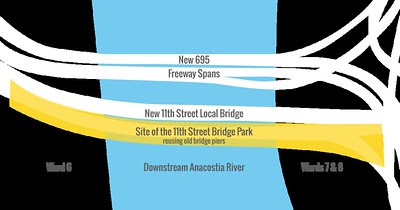
DC's 11th Street Bridge Park project

 Is written up in the Washington Post ("D.C.'s first elevated park will link neighborhoods divided by river") as it nears moving towards construction within the next couple years.

When it was first proposed, I was skeptical--I think as an idea it's cool, but it's in an inhospitable location and isn't near residential areas so there isn't a lot of opportunity for adjacent revitalization, which is what you want from an infrastructure investment of more than $100 million ("Flashy one-offs vs. a program: the proposal for an 11th Street bridge linear park and the rest of the city," 2013; "DC and streetcars #4: from the standpoint of stoking real estate development, the line is incredibly successful and it isn't even in service yet, and now that development is extending eastward past 15th Street," 2015).  


Then I was invited to serve as a Ward 6 representative on the Design Advisory Committee when they were picking a design for the project.

It led me to write a bunch of great entries about river-based revitalization, planning, East of the River revitalization, parks, etc.

-- "The Anacostia River and considering the bridges as a unit and as a premier element of public art and civic architecture," 2014
-- "DC has a big "Garden Festival" opportunity in the Anacostia River"," 2014
-- "A world class water/environmental education center at Poplar Point as another opportunity for Anacostia River programming (+ move the Anacostia Community Museum next door)," 2014
-- "Saving the South Capitol Bridge as an exclusive pedestrian and and bicycle bridge," 2014

This predated my involvement in that:

 -- "Wanted: A comprehensive plan for the "Anacostia River East" corridor," 2012

But after the design selection process was over, I was no longer involved ("11th Street Bridge Park finalists," 2014).

 The Bridges now.

What's proposed, rendering with the park in place. 


 "New 11th Street Bridge Park design aims for better trail connections," Washcycle

While I remain impressed with the organizing effort, how the group exhibits at festivals and are focused continually on outreach, and have organized many millions in funding to ward off the gentrification and displacement they expect to happen because of the addition of a high quality park to the area, I am back to my position that it's cool but not the best use of resources.

For one, unlike various analogous park infrastructure projects like:

the Bridge Park won't be well located, in the midst of residential areas and otherwise vibrant (or potentially vibrant) places.  It's next to a freeway.  While being over the river is cool, you'll have to make an effort to get to the Park. 

It's more comparable to how Roosevelt Island National Monument is in DC but can only be reached from Virginia ("Revisiting: Access to Theodore Roosevelt Island, a national park in Washington, DC") or how you have to take a ferry to Governor's Island in New York City. 


From a resource standpoint and the success of raising over $100 million, I can't but help but think that those resources would have far greater effect being invested in existing and under-invested parks, recreation facilities, cultural resources, and other civic and community assets in Wards 7 and 8.

-- "Five examples of the failure to do parks and public space master planning in DC," 2021 
-- "Social urbanism and equity planning as a way to address crime, violence, and persistent poverty: (not in) DC," 2021
-- ""Utility" infrastructure as an opportunity for co-locating urban design and placemaking improvements," 2020
-- "Planning for place/urban design/neighborhoods versus planning for transportation modes: new 17th Street NW bike lanes | Walkable community planning versus "pedestrian" planning," 2021


-- "Extending the "Signature Streets" concept to "Signature Streets and Spaces"," 2020
-- "From more space to socially distance to a systematic program for pedestrian districts (Park City (Utah) Main Street Car Free on Sundays)," 2020
-- "Why doesn't every big city in North America have its own Las Ramblas?," 2020
-- "Diversity Plaza, Queens, a pedestrian exclusive block," 2020

For example, the city refuses to fully fund the reconstruction of the Fort Dupont Ice Arena ("Fort Dupont Ice Rink supporters accuse District of mishandling plans for new arena," "This is shameful: In a wealthy hockey town, D.C. kids have nowhere decent to play," Washington Post).

And something I missed some time ago, and have never written up as a dedicated entry, but should be a priority, would be undergrounding DC-295 and I-295 in the vicinity of the Anacostia River.  

I have discussed undergrounding/decking for North Capitol Street, the Southeast-Southwest Freeway, and parts of Connecticut Avenue in the core.

-- "DC and "city repair" of the urban grid," 2020

Freeway undergrounding and removal is a trendy move in urban planning these days ("Can Removing Highways Fix America's Cities?," New York Times).  And these days the US Secretary of Transportation is pushing this as an environmental justice measure ("Pete Buttigieg launches $1B pilot to build racial equity in America's roads," NPR).  DC should get on the bandwagon.

(I also argued that DC should work with Prince George's County to create a "Trail Towns" initiative along the Anacostia River, modeled after the initiative in Pennsylvania along the Great Allegheny Passage.)

SO much needs to be done East of the River that the Bridge Park seems really frivolous.

-- "Why can't the "Bilbao Effect" be reproduced? | Bilbao as an example of Transformational Projects Action Planning," 2017
-- "Downtown Edmonton cultural facilities development as an example of "Transformational Projects Action Planning" ," 2018

Labels: , , , , , ,

Thursday, March 17, 2022

Trains and emergency evacuation: Ukraine and freight/emergency transportation planning | Homogeneous versus heterogeneous transportation systems

 A couple weeks ago, charlie called our attention to a great article ("On board the mobile command that's keeping Ukraine's trains running," Business Insider) on how the Ukraine Ministry of Infrastructure has responded to managing its train network in wartime conditions, with special focus on the use of trains to evacuate Ukrainians to safer areas out of the country, and how the staff no longer operates from a fixed position as that would be a highly vulnerable target for attack.  

With regard to transportation in wartime, disasters, and emergencies, there are (at least) three issues: (1) heterogeneous transportation system; (2) managing railroads and road systems; (3) capable of being ingmanagerially flexible.

Kamyshin starting a conference call with the top managers 
of Ukraine's six regional railroads. 
Alan Chin for Insider

People crowding a train platform in Kharkiv, Ukraine
Twitter photo: Nexta_TV

People waiting for trains to take them from Lviv to Poland. 
On Sunday only two trains were running and only women and children were allowed to board.
Photograph: Vincent Haiges/Avalon

Around that time was an NPR article about a volunteer effort in Poland to restore an abandoned train line to facilitate refugee trains from Ukraine ("Poland rebuilds abandoned rail tracks to Ukraine to help refugees fleeing the war").  (Also see "12 hours on board a packed train out of Ukraine," BI, "‘Everyone was fighting to get on a train’: the desperation of Ukrainians trying to reach safety," Guardian).

Ukrainian refugees lining up for services at the Berlin Train Station on March 8, 2022
Michael Sohn, AP

Since there have been other articles on train stations as gateways for Ukrainian refugees ("Berlin train station turns into refugee town for Ukrainians," AP, "Berlin's main train station becomes Ukrainian refugee welcome center," Reuters).  From the NYT:

Now Russia’s invasion of Ukraine is turning Europe’s trains and ornate imperial-era stations into a new refugee crisis network, putting them on a war footing yet again. At least a dozen state- and privately owned railway operators have opened up their services for free to refugees, and their cargo trains are being deployed to bring humanitarian aid to Ukraine.

When I first read the Insider article, I thought about how the US has built, for the most part, a homogeneous mobility paradigm, around cars and trucks and the "Interstate Highway and Defense System" network of high speed roads across the nation.

Trucks and roads work well for flexibility, but have capacity constraints both for loads and the number of vehicles, aren't particularly energy efficient, and require lots of personnel.  And they can create significant congestion.

Trains operate with small numbers of personnel and are energy efficient, but can be slower, certainly are less flexible, and are definitely vulnerable in wartime to tracks and trains being bombed. (Bombed tracks can be repaired.)

But when the highway system was created, no one ever considered there would be a time when oil would be super high in price and labor availability would be seriously constrained ("Taking Europe's Trains to Escape, or to Teach, A Conflict's Front Lines." NYT).

Freight transportation planning.  But in any case, the current supply chain logistics problems we have in the US indicate a lack of an adequate and integrated freight transportation planning policy that includes all the elements, including shipping, ports, trains, trucks and related labor issues ("Port of Los Angeles Stops Short of 24-Hour Operations, Unlike Long Beach," Wall Street Journal, "Rigged: Forced into debt, worked past exhaustion, left with nothing," USA Today).

Emergency evacuation.  And I thought back to various hurricane evacuation efforts in Louisiana (Katrina) and Texas (Rita), how the road system was overwhelmed, leading to traffic deaths, and how some people called for train evacuations not realizing that we have so little resources available for passenger train service that unlike in Ukraine today or Europe more generally, for the most part in the US, passenger train service isn't a realistic option for emergency transportation.

Evacuation from Houston in advance of Hurricane Rita, 2005.

If there are multiple tracks, all railroad tracks can be used for unidirectional traffic, which for safety reasons, is not possible with freeways.

Heterogeneity versus homogeneity in transportation planning.  In any case, the Ukraine example, as sad and as horrifying as it is, demonstrates the importance of hetereogenity in transportation planning and the provision of infrastructure, that you need both train service and car/truck service for both passenger and freight mobility in times of emergency. 

Labels: , , , , , ,

Friday, October 02, 2020

DC and "city repair" of the urban grid

I have written a bunch of pieces about tunneling commuter arteries and decking over freeways and principal arterials that too often scar the city, split neighborhoods, and foul up the street grid developed by L'Enfant.

-- "Who knew? There's been a freeway deck in Oak Park, Michigan over I-696 for almost 30 years" (2018) 

-- "London Mayor proposes roadway tunnels to divert surface motor vehicle traffic and congestion," (2016) 

-- "Tunnelized road projects for DC and the Carmel Tunnel, Haifa, Israel example--tolls," (2011) 

-- "Maglev as an opportunity for DC to underground through traffic on New York Avenue," (2020) 

-- "Yes, public and nonprofit investments in the city spur further reinvestment and change: is this a bad thing or a complicated thing?" (2019)

Boston: before and after the Big Dig.  AP photo.

A number of cities around the world have done this in various ways -- getting rid of freeways more generally (San Francisco's Embarcadero Freeway, Milwaukee, Boston's Big Dig, Seattle's Highway 99, albeit because of earthquake risk), along waterfronts (Portland, Oregon) or restoring rivers that had been covered up (Seoul) and/or tunnelizing major freeways (Marseille, Thessaloniki, Madrid) -- or have proposed doing so.

Note that this is expensive to do, but might be cheaper than the cost of rebuilding freeways at the end of their useful life.  Generally, it's "affordable" in central business districts with high property values, when "new land" created supports new high intensity development.

And I just mentioned Utrecht's now completed program to restore sections of the city's ring canal that had been converted to below grade roadways.

Building a deck over a couple blocks of the I-395 Freeway, between Massachusetts Avenue and D Streets NW.  Here the freeway was wide enough to allow for the construction of multiple large buildings, in an area of high value.

And DC has decked some sections of the I-395 Freeway, including the most recent "Capitol Crossing" project.

Foggy Bottom as an opportunity.  Greater Greater Washington reprinted an entry that discusses a 1997 proposal to do this in Foggy Bottom, which is cut up by arterial tunnels, a stub of I-66, and the Whitehurst Freeway.  Kennedy Center, the performing arts complex, is a kind of an island in the midst of roadways.

-- "What if Kennedy Center was [sic] part of Downtown DC?"

When I suggested that decking be employed with regard to the Southeast-Southwest Freeway, I was definitely remiss in not mentioning the similar opportunity in Foggy Bottom. (Although the FB article doesn't discuss the poor placement of Kennedy Center from the standpoint of what Jane Jacobs called "mixed primary use" and her example of the creation of a standalone arts district in the Oakland neighborhood in Pittsburgh, rather than downtown.)


Portland's City Repair urban design advocacy group.  I use the term "city repair" in honor of the City Repair organization in Portland, Oregon.

A "repaired" intersection in Portland.

They focus on "repairing" city streets with the aim of supporting walking and biking, converting the streets from their hitherto overwhelming focus on motor vehicles.

-- video

Cities should create "Urban Design Opportunity Plans."  Most cities have plenty of opportunities for "city repair" and urban design advocacy agendas for such, applying the "Transformational Projects Action Planning" approach, should be developed, at the city-wide scale  more generally, and at the neighborhood scale, like the way I suggested for the Dupont Circle neighborhood in DC or Silver Spring, Maryland:

-- "Planning urban design improvements at the neighborhood scale: Dupont Circle, DC" (2019) 

--  "More about making 17th Street between P and R a pedestrian space on weekends" (2019) 

 -- PL #5: Creating a Silver Spring "Sustainable Mobility District" (2017)

 - Part 1: Setting the stage - Part 2: Program items 1- 9 - Part 3: Program items 10-18 

 - Part 4: Conclusion

or what Alexandria, Virginia is doing around its waterfront, at the foot of King Street, or for more pedestrianized areas within cities like Las Ramblas in Barcelona or the plaza program in New York City.

Labels: , , , , , ,

Friday, May 17, 2019

For DC, a congestion charge is not the way to go

One problem with a congestion charge, federal government vehicles probably would be exempt, and foreign embassies and organizations like the World Bank probably wouldn't pay.  Daily Mail photo, "Foreign embassies owe £75m in unpaid London congestion charges and U.S. diplomatic staff have racked up the most debt with fines totalling £8.1m."

WAMU-FM/NPR reports that DC City Council has allocated money to study the imposition of a congestion charge ("Should D.C. Toll Streets During Peak Traffic Periods? Council Wants To Study ‘Congestion Pricing’").

Congestion charges have two different purposes.

(1) reduce traffic by inducing people to shift trips to other modes or to not make trips altogether.  (And by reducing traffic, they help to speed up the remaining traffic, including surface bus transit.)

This is done through the classic recommendations of instituting a "tax" where spillover costs are not normally captured within pricing.

(2) provide an additional source of funding for transportation projects, ideally prioritizing sustainable mobility initiatives.

First, much of the metropolitan area's "worst" congestion is in the suburbs, and is on highways, not in DC proper, although getting to and from DC is one of the contributing factors.

-- "3 DC-area roads make list of America's 50 worst traffic bottlenecks," Fox5

Most studies that rank "DC" bad for traffic call the entire metropolitan area after the center city.  The fact is that DC does have a problem with congestion on certain streets in the core (K Street, I Street primarily) the reality is that most of the streets in the core aren't that congested.

Transit--Metrorail primarily despite its current problems--works!
Washington Capitals fans at the Gallery Place Metrorail Station
Washington Capitals fans exiting the Metrorail system.  One great thing about having the city's main arena in the core, served by 3 subway lines directly, and just a few blocks from 3 more lines, is how even a preponderance of suburbanites take transit to events held there.

I make this statement by the fact that during rush hour, it's possible to run red lights on a bicycle without any fear of oncoming traffic.

The major exception is the main commuter arteries such as 16th Street, Blair Road, Rhode Island Avenue, New York Avenue (itself congested because of the way it connects I-95 and I-695 for through trips to Virginia and Maryland). Although, some of this traffic would be interdicted I supposed by people switching to other modes in response to a congestion charge in Downtown.

Second, and most importantly, for DC to successfully levy a congestion charge, it has to be inalterably the #1 destination in the region for commerce subject to minimal competition for business relocation.

That's the case in cities like Singapore, Stockholm, or London, which have already instituted congestion charges, or New York City for Lower Manhattan, which has agreed to include a congestion charge going forward--not because they care that much about congestion, but because they need a funding source for rehabilitating the New York City Subway system.

I don't think it's the case for DC.  Especially with the current federal administration and its willingness to eliminate agencies altogether or move them outside of DC and the DC metropolitan area.

My paralyzing fear is that Maryland and Virginia would actively market business relocation against DC, making the point that you can get to their business districts without having to pay a congestion charge.

I don't think either state or its jurisdictions can really be trusted on this.

In fact, when I saw a presentation by the then planning director of Arlington County at the National Building Museum in 2002, I went up to him afterwards and suggested he retitle his presentation "how to kill DC."  That continues to be the case, given how Crystal City has just landed Amazon as a major tenant and Rosslyn has been landing corporate headquarters such as Nestle Foods.

Granted, you can argue that high occupancy tolls are a form of congestion charge. But some argue that the reason that Virginia made I-66 within the Beltway a toll road is to encourage businesses to relocate to Virginia from DC, thereby being able to get to and from a new location without tolls.

Alternative one: transit withholding taxIf the point of doing a congestion charge is raising funds, what I have recommended for years, but the federal government would have to agree, and it would be helpful for the suburbs to agree too, would be a transportation withholding tax.

It's done in France--providing a majority of the operating funding for transit service (France has successful light rail systems in many of its regional cities, not just in Paris), as well as certain areas of Oregon (Portland, Eugene), and for the MTA system in New York State (although I argue there it is too gross-grained, out-state residents served by railroads should pay less than core residents served by the subway--instead the same rate is assessed across the board).

-- "Commuter/mobility tax discussion for DC," 2012
-- "Metrolinx Toronto: 25 potential tools to fund transit-transportation infrastructure," 2013

Alternative two: commuter tunnel and transitway networkIf the point of a congestion charge is interdicting nasty traffic, in addition to investing in more and better transit, I have argued for the creation of some roadway tunnels on commuter arteries, e.g., North Capitol-Blair Road, to shift commuter traffic away from surface streets, because it has deleterious impact on the quality of neighborhood life.

These would be covered by tolls, not unlike HOT lanes. Maybe they wouldn't fully pay their way, but by shifting through traffic away from neighborhoods, it could be a cost worth subsidizing.
I-695 in DC looking west from 4th Street SW
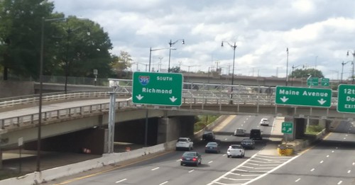
The Southeast-Southwest Freeway (I-695) in DC looking west from 4th Street SW.


The program should include dedicated transitways.  DC will be testing some Downtown, and has implemented them on and off on 7th Street/Georgia Avenue NW. (Bus advocates in London argue that with dedicated transitways, bus throughput improvements would be even greater.)

-- "Dedicated bus lanes coming to H and I streets this summer," Washington Post
-- "It's been a drawn out process, but DC is in the process of creating transitways on 16th Street NW," 2017

This program could also include some road decking, such as on North Capitol Street and the Southeast-Southwest Freeway.

-- "Tunnelized road projects for DC and the Carmel Tunnel, Haifa, Israel example--tolls," 2011
-- "London Mayor proposes roadway tunnels to divert surface motor vehicle traffic and congestion" 2016
-- "Maryland HOT lane study versus "corridor management" and regional scaled transportation planning," 2018
-- "Who knew? There's been a freeway deck in Oak Park, Michigan over I-696 for almost 30 years," 2018

I haven't written about it, but tunnelizing DC-295/The Anacostia Freeway, would be a boon to the quality of life and economic potential of a large section of the city East of the River.
Anacostia Freeway (DC 295)


This video by Bossi of DC 295 has unrelated sound.  I'd turn it off before listening, unless you want to listen to an old Diane Rehm radio broadcast.

If we had true metropolitan transportation planning, the Maryland HOT lane study could be coordinated with a DC tunnel/decking study.  For example commuter tunnels on 16th Street and Georgia Avenue would make sense to be integrated into the Maryland system.

-- "Here's a look at who's using Northern Virginia's 495 and 95 Express Lanes," Washington Post, 2018
-- "Poll: 61 percent of D.C.-area residents favor plan to add toll lanes to Beltway, I-270," Washington Post

Labels: , , , , , , ,

Saturday, November 24, 2018

Who knew? There's been a freeway deck in Oak Park, Michigan over I-696 for almost 30 years

Freeways have been controversial in cities for many reasons.  They facilitate sprawl.  They sever neighborhoods.  They are noisy and impair air quality.  They've been used as a deliberate urban renewal device targeting low income communities and people of color.  They also support economic activity.

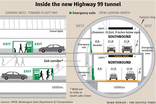
A more modern response to some of these problems is to tunnel freeways.  That happened with the "Big Dig" in Boston ("10 years later, did the Big Dig deliver?," Boston Globe) and is happening in Seattle, where the elevated Highway 99 is being re-created as a tunnel, although there the motivation isn't aesthetic, but has to do with the potential for earthquakes and re-engineering for withstanding them.

It ended up being cheaper to build a tunnel than to rebuild the freeway.  It will be opening early next year ("When does the viaduct close? How much is the tunnel toll? Your guide," Seattle Times).

Graphic of Highway 99/Alaskan Way Tunnel, Seattle
Graphic of Highway 99/Alaskan Way Tunnel, Seattle.

It's happened in a bunch of cities in Europe including Madrid, Marseille and Thessaloniki.  Singapore has a series of underground freeways although the country has dialed back on the expansion of this network.

-- "City Parks, Like Madrid Río, Stand Where Highways Did," New York Times
-- "6 Freeway removals that changed their cities forever," Gizmodo

DC has some decks over I-395 between the National Mall (where it is tunneled) and between Constitution Avenue and K Street NE.

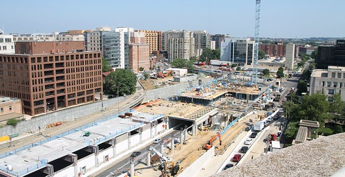
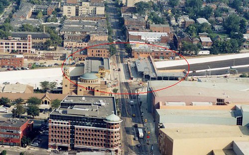
 A big development called Capitol Crossing is underway between Massachusetts Avenue and D Street, where a multi-building complex is being constructed.
Capitol Crossing freeway deck under construction

There's been talk about doing a similar development in Rosslyn, Virginia, but because the cost of construction is so high, it's not economically feasible to pursue it at this time, given the high vacancy rates for commercial office space in Northern Virginia.

I've suggested that such tunnels ought to be constructed in DC to divert commuter traffic from surface streets, because it has such deleterious impact on neighborhoods.

-- "Tunnelized road projects for DC and the Carmel Tunnel, Haifa, Israel example--tolls," 2011

Decks for parks.  The Bloomingdale Civic Association in DC is pursuing "decking over" part of North Capitol Street, not so much because they are looking to tunnel commuter traffic, but because of how the tunnel separates the Bloomingdale and Eckington neighborhoods, and they recently got a grant from the American Architecture Foundation to being planning for this.

They call this the Bloomingdale Village Square/Village Center project.

Separately, there is a parallel effort in the Dupont Circle neighborhood to deck over part of Connecticut Avenue where it is tunnelized, although I rue that it is not part of a broader package of complementary urban design improvements, something I'm long overdue in writing about.

-- Connecticut Avenue Streetscape and Deck-Over Project, DC Department of Transportation

The Klyde-Warren Park in Ballas is one example of a deck over a freeway for a park, and it's gotten a lot of press over the past few years because of its trendsetting nature ("Cities Are Banishing Highways Underground — And Building Parks," Stateline).
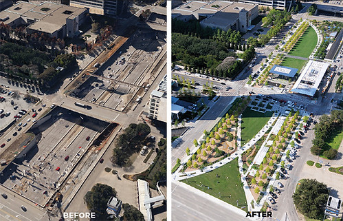
Klyde Warren Park, Dallas, before and after photos

It took decades to build finish building a suburban freeway in the Oakland County section of Greater Detroit, because it had to be threaded within existing communities ("AFTER 32 YEARS, MOTOR CITY GETS NEW LIFELINE," Chicago Tribune, 1989).

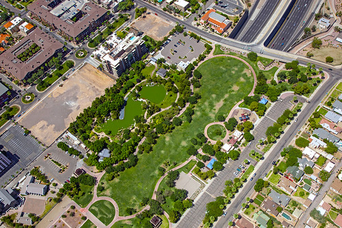
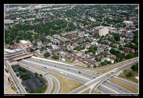
Imagine my surprise earlier in the week to learn that there's been a park deck over the I-696 Freeway in Oak Park, Michigan in Oakland County for almost 30 years.
800px-Interstate_696_pedestrian_plazas_Oak_Park
This happened a couple years after I had moved to DC, and the primary motivation for construction was to enable  people's ability to walk to temple on the Sabbath in a comfortable manner in a heavily Orthodox Jewish community..

It happens that now there are problems with the bridge and parts of it need to be reconstructed ("Park-like Oak Park bridge over I-696 slated for $25-$30M replacement," Detroit Free Press).

Apparently, part of I-10 is routed underground in Phoenix through the construction of a series of bridges over the freeway, creating a tunnel about one-half mile in length and is topped by a park ("a href="https://www.azcentral.com/story/news/local/phoenix-contributor/2016/11/01/why-does-downtown-phoenix-have-tunnel/92709238/">Why does downtown Phoenix have a 'tunnel?'," Arizona Republic). It was constructed in 1990.
Margaret T. Hance Deck Park, Phoenix, over I-10

Another building focused freeway cap.  In Columbus, Ohio, one of the overpasses for the I-670 freeway has a deck constructed alongside, for buildings, which connects the street fabric between the two sides of the freeway ("Ohio highway cap at forefront of urban design trend," Chicago Tribune).
I-670, Columbus, Ohio

I-670 freeway cap, Columbus, Ohio
Photo: Meleca Architecture and Urban Planning


A building cap over railroad tracks in Queens, New York.  This is comparable to the Lefferts Boulevard Bridge atop of the tracks at the Long Island Railroad Station in Kew Gardens, Queens, in New York City.  That bridge was constructed in 1930 and is in need of replacement ("A Bridge, the Rickety Heart of Kew Gardens, Gets a Reprieve," NYT).

Labels: , , , , ,