PL #5: Creating a Silver Spring "Sustainable Mobility District" | Part 2: Program items 1 - 9
The discussion of the proposal to create a Silver Spring "Sustainable Mobility District" is very long.
So it's broken up into four sections, plus three related posts:
-- Setting the stage for the Purple Line light rail line to be an overwhelming success: Part 1 | simultaneously introduce improvements to other elements of the transit network
-- Part 2 | the program (macro changes)
-- Part 3 | influences
-- Part 4 | Making over New Carrollton as a transit-centric urban center and Prince George's County's "New Downtown"
-- PL #5: Creating a Silver Spring "Sustainable Mobility District"
- Part 1: Setting the stage
- Part 2: Program items 1- 9
- Part 3: Program items 10-18
- Part 4: Conclusion
- Map for the Silver Spring Sustainable Mobility District
- (Big Hairy) Projects Action Plan(s) as an element of Comprehensive/Master Plans
- "Creating the Silver Spring/Montgomery County Arena and Recreation Center"
-- Part 6 | Creating a transportation development authority in Montgomery and Prince George's County to effectuate placemaking, retail development, and housing programs in association with the Purple Line (to come)
-- Part 7 | Using the Purple Line to rebrand Montgomery and Prince George's Counties as Design Forward
========
Proposed program
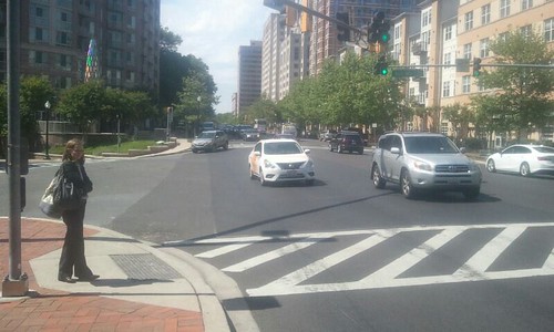
1. Make Fenton Street the primary "east side" sustainable mobility corridor -- a "Signature Street" -- in Downtown Silver Spring/Silver Spring Triangle. The street already has high quality roadside treatments, including brick sidewalks, some bike racks and bike share stations, some bus shelters, sidewalk bulbouts, and trash and recycling receptacles. Fenton Street is used for certain Montgomery County Ride On bus routes, including the Silver Spring circulator, and a Metrobus route.
The street has both "chain" and independent retailers, with chains concentrated north of Wayne Avenue, although the independent retail spaces are likely to be under threat as properties are redeveloped.
The primary section for this treatment will be from Colesville Road to Montgomery College. It should be extended south to Takoma Avenue (Takoma Park), and a northward extension from Colesville Road to Cameron Street should be considered.
Change the posted speed limit to 20 mph in recognition of the corridor being designated a sustainable mobility priority corridor.
2. Make East-West Highway the primary sustainable mobility corridor on the "west side" of the Silver Spring Triangle. This would be from Colesville Road to Georgia Avenue, with a continuation of the treatment across Burlington Avenue to Fenton Street.
East-West has high quality aesthetics already, with wide sidewalks, tree cover, but limited retail, including the Bump & Grind coffee-record shop and the Denizens brew pub. The street is lined with large apartment buildings, with service businesses clustering towards Georgia Avenue. The Blairs mixed use housing and retail center will be redeveloped and intensified. Most of the apartment buildings are fronted by plaza areas, and the small Acorn Park is at 13th Street.
This upgraded corridor will help link west side residents to retail amenities, parks, and Montgomery College, and will encourage the creation of more "shop space" on East-West Highway.
Consider changing the posted speed limit to 20 mph in recognition of it being a sustainable mobility prioritized corridor (although this is a State road). Currently this section is dominated by the car, but over time this will change with the implementation of this program, and the posted speed limit should change accordingly.

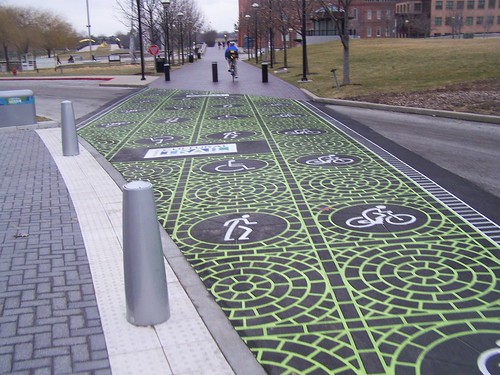
3. Create a cycletrack network on Fenton Street and East-West Highway. To make each street "Signature," remove the street parking and install a bi-directional cycletrack for high quality and safe biking, with the focus on providing access to the civic and cultural facilities along the Fenton Street spine.
Provide a connecting cycletrack on Wayne Avenue from the Silver Spring Transit Center to Fenton Street, and between East-West Highway and Fenton Street via Burlington Avenue.

First Street Cycletrack by Union Station, Washington, DC. Photo by Dan Malouff, BeyondDC.
Besides the obvious ICT example, closer to home is how in the NoMA district of DC, the Metropolitan Branch Trail connects to a separate 1st Street Cycletrack to Union Station, with a one block cycletrack link on M Street.
A new Fenton Street cycletrack with the connection from the Silver Spring Transit Center should be considered a high quality extension of the Metropolitan Branch Trail through the core of Silver Spring.
Syracuse Connective Corridor with cycle track.
4. Create a network of pedestrian scramble intersections, where one designated signal phase is exclusively for pedestrians: on Colesville Road at East-West Highway, Second Street, Georgia Avenue, and Fenton Street; on Fenton Street at Ellsworth, Wayne Avenue, and Bonifant Street; and at the intersection of Wayne and Georgia Avenues. And a more defined crosswalk treatment should be provided at the mid-block crossing at Ellsworth and Georgia Avenues, crossing east-west.
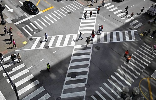
Pedestrian scramble, Jackson Boulevard and State Street, Chicago. Photo: John J. Kim, Chicago Tribune.
While the road network prioritizes motor vehicle throughput, some places have far more pedestrian traffic than motor vehicle traffic. One way to better balance movement for pedestrians is to provide a "pedestrian scramble" or "Barnes Dance" intersection treatment where one phase, including diagonal crossing, is exclusively for pedestrians.
Back when Downtown DC was the region's primary shopping and office district, DC had multiple such intersections. More recently, one was created at 7th and H Streets NW and one is being installed at 14th and Irving Streets NW. I have argued that DC needs multiple such intersections as a traffic safety and mobility rebalancing intervention ("Barnes Dance intersections as possible solutions").
Fenton Street has the best conditions for this in Silver Spring because unlike Colesville Road and Georgia Avenue, it's not particularly wide.
Nonetheless, creating such intersections along Colesville Road will strengthen the pedestrian character of the area as well make Colesville Road a transit-priority corridor in keeping with the siting of the Metrorail Station and SSTC. The Wayne Avenue-Georgia Avenue intersection supports both the transit center and the shopping district and one corner functions as a small square.
There is also a mid-block pedestrian crossing on Georgia Avenue at Ellsworth (which doesn't continue west across Georgia Avenue) which needs a more defined crossing treatment comparable to markings for the street crossings on the Indianapolis Cultural Trail.
The ICT is marked by high quality markings at street crossings, making very clear the prioritization of non-motorized mobility.
5. Rearticulate parking services on Fenton Street/across the Silver Spring Triangle to accommodate cycletracks/removal of street parking. To create cycletracks on Fenton Street and East-West Highway, street parking will have to be removed. There are 70 metered parking spaces on Fenton Street from Colesville Road to Richmond Avenue.
Despite the reality that within a half block of Fenton Street, between Ellsworth Avenue and Silver Spring Avenue, Montgomery County has about 4,000 parking spaces in three parking structures and multiple surface lots, as well as additional street parking on the cross streets, when I raised this concept with planners from two different sections of the county transportation agency I got incredible pushback, expressing serious fear of complaints, from businesses especially.

In and around the core of Silver Spring, Montgomery County's parking unit has 10,000+ public parking spaces in structures and lots, as well as street parking.
Plus there are thousands more spaces in private lots and private buildings and non-affiliated public facilities (e.g., Montgomery College has more than 800 parking spaces in two garages and surface lots). Ideally some of this "private parking" could be integrated into a unified public-private parking network through the creation of a "shared parking" network.
Clearly, the issue isn't that there isn't enough parking, as much as it is a lack of knowledge about choices and availability, and certain restrictions on use. Also see "Less parking in the suburbs? Some communities head in that direction," Boston Globe).
This is less of an issue on East-West Highway--there the road is wide but for the most part, it's wide enough to add a cycletrack without removing the limited parking that exists.
Although by taking parking off Fenton Street we have to acknowledge the loss of spaces immediately in front of retail establishments, which will require a bit of walking for some patrons.
Note that the planners I spoke with argued for what they are doing currently, putting cycletracks on Spring Street and Second Avenue, as a way to build support for being more bold in the future.
I disagree that those projects will make much difference in terms of public perceptions, because for the most part, those streets lie outside the highly visible core, and most people won't see the facilities and therefore their existence won't make much difference to the support of new placemaking improvements. For an alternative view, see the recent experience in Norfolk, Virginia ("10 months after launch, has Norfolk's bike lane loop defied the early critics?," Norfolk Virginian-Pilot).
Note that "situational awareness" is an issue in my DC neighborhood too, where we are dealing with an on-street cycletrack proposal as part of the ongoing construction of the Metropolitan Branch Trail.
I was surprised that most of my fellow Public Works and Infrastructure Committee members are unfamiliar with the existing cycletracks elsewhere in DC, many of which I would consider national best practice.
My colleagues are involved citizens who are engaged. If they aren't knowledgeable, how can we truly expect that the average Montgomery County car-centric resident will seize on one of these semi-invisible cycletracks as a reason to expand the cycletrack network more directly?
I think rather than being timid, the County needs to be bold, using the above-mentioned examples of placemaking-forward projects as models, and look at this as a bigger/big initiative, rather than being satisfied with the incremental addition of some infrastructure and facilities over multiple decades.
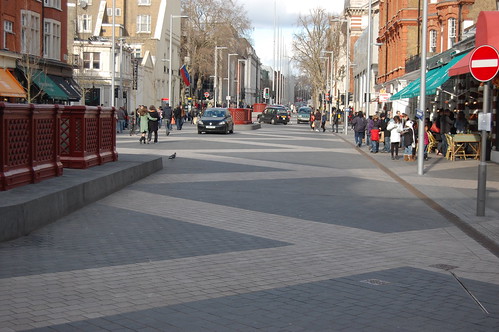
Exhibition Road South, Kensington borough, London. Exhibition Road is lined by museums and the street was repaved in a special treatment to better balance pedestrian use vis a vis the car, in keeping with the large volumes of pedestrian using the street.
The parking services program proposed below should be delivered across the Silver Spring Triangle, not just on Fenton Street, but the discussion focused on Fenton Street because of how it will serve as the spine of the civic asset network and because that is where removing street parking is likely to be the most controversial.
The solution: provide real-time information on parking, complemented by a valet parking network, and a simplified micro-shuttle service. While digital/real-time parking information guidance is provided at most airports and increasingly at shopping centers--where information is presented on each level of a parking structure listing the number of spaces available--this is not the case in cities more generally.

While many of Montgomery County's county-run parking structures do provide parking guidance info within the structure, including the Wayne Avenue and Town Center parking garages in Silver Spring, they don't provide feed this information to signage placed on the streets within the various "parking districts."
Some cities do provide such information systems, based on solutions offered by companies like TCS International, Swarco, and Siemens.
Recommended components of an active parking services and guidance program:
- create an integrated parking guidance information system with signage, mobile applications, and printed materials
- precede the launch of this program with a door-to-door campaign to the businesses, as well as with residents and other stakeholders
- provide valet parking stations along Fenton Street and throughout Silver Spring as needed, so people can "drop off" and retrieve their cars at various points across the district

- supplementing the existing VanGo circulator bus service, consider providing a micro-shuttle service from parking facilities to destinations, using small electric vehicles such as those used in Downtown San Diego ("‘FRED’:Downtown free shuttle launching Tuesday: Ad-backed service aims to ease parking panic," San Diego Union-Tribune)
- include "private" parking facilities open to the public in the digital parking guidance information network of signs, maps-brochures, and e-applications.
By providing real-time signage, mobile apps, and brochures--which should include all parking open to the public, plus valet service and shuttles, people can be trained to park and walk and think of it as a quality element of the experience, rather than a hindrance, especially when that walking takes place in an aesthetically attractive environment.
I've noticed that many commercial districts don't do a good job of listing parking options on widely distributed brochures. Hyattsville's parking guide is an exception and a model.
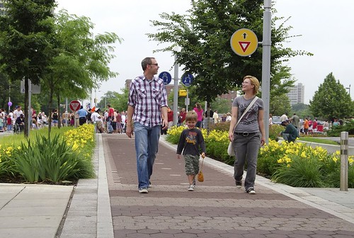
6. Incorporate greenspace improvements on Wayne Avenue between Fenton Street and Sligo Creek Parkway, treating Wayne Avenue as a "Parkway." This street is fronted mostly by single family housing, with a smattering of apartments, some institutions like churches, and the Silver Spring International Middle School.
The wide sidewalk on the north side of the street functions as the "Silver Spring Greenway" trail connecting to the school and the Sligo Creek Trail and Park and a playground. The Trail in turn connects to the Northwest Branch Trail and the Anacostia River Watershed trail network.
Because the street will remain primarily low density residential, I think the best treatment in conjunction with the Purple Line light rail is to accentuate its park-like qualities, treating it as a linear park/parkway, with specially maintained curbside plantings. Below is an example from the Indianapolis Cultural Trail.
Ideally too the track right of way could be planted with grass as it is shown in the Paris example below. Grass could be planted between the tracks and probably survive on Wayne Avenue, east of Fenton Street, because of the comparatively low amount of motor vehicle traffic.

Montgomery County (Rock Creek Parkway, Sligo Creek Parkway) and the area through NPS (Clara Barton Parkway, George Washington Parkway, etc.) has a great deal of historical experience with parkway development and maintenance.
A contemporary example is how St. Paul, Minnesota is extending their parkway system through an initiative they call the Grand Round. From the Minneapolis Star-Tribune article,"Planning for St. Paul's Grand Rounds pushing forward":
The St. Paul Grand Round is a visionary project to "continue the development of approximately 30 miles of scenic parkways connecting neighborhoods across the entire city with off-street bicycle and pedestrian facilities," a website touting the project says.It's part of a St. Paul city-specific initiative called Vibrant Places and Spaces.
The parkway concept seems to be a good model for integrating light rail routing in suburban locales, although incorporating light rail in park-like settings seems counter-intuitive, but the way Barcelona and Paris use grass in trackways shows that it can work.
Wheelock Parkway, Rendering, St. Paul Grand Round
7. Extension of the public realm network through a small "road diet" program. There are opportunities to add to the open space/park space network by reworking the road network slightly.
- Extend the pedestrianized Ellsworth Avenue east across Fenton Street to the entrance of the Town Center Parking Garage on Ellsworth Street (between Fenton Street and Veterans Place). This would extend the pedestrian mall at the cost of 15 metered parking spaces. As it is, sometimes this stretch is closed to traffic on weekends in favor of street festivals.
- Eliminate the "slip lanes" at the Fenton Street/Philadelphia Avenue/Burlington Avenue intersection. These lanes are minimally used, and promote higher speed driving in what should be a sustainable mobility corridor. Removal of the slip lane on the east side of Fenton would allow for the creation of an ornamental entry garden and the creation of a better connection to an on-road bike path.
- Extend park space on the west side of the Fenton Street-Philadelphia Avenue intersection, enlarging and connecting the Community Garden and the Fenton Street Park by using the former slip lane space as well as the stub of Philadelphia Avenue. From the west, Philadelphia Avenue extends from Selim Road (a kind of frontage road along Georgia Avenue), but stops short of Fenton Street. By eliminating the stub end, park space can be added, connecting the Garden and the Park. This will require the removal of 6 parking spaces.
Similar opportunities may exist elsewhere and should be considered.
8. Create and implement a complementary set of urban design treatments. The sustainable mobility infrastructure outlined above should be complemented with high quality sidewalks, street furniture, public art, and other amenities.
This is partly happening already. For example, most of the sidewalks on primary streets are high quality, often brick. There is a good collection of waste and recycling cans, some bike racks--although the ones on Ellsworth don't meet professional standards, bike sharing stations, public art installations, gateway signage, a network of historical markers, a mural at the Silver Spring Metrorail station, etc.

Bank Street, Adelaide, Australia, by Sam Songailo with Taylor Cullity Leathlean landscape architects. Photo by Emily Taylor. It would be interesting to use this kind of road treatment on parts of Fenton Street
Urban design/streetscape guidelines and improvements. A big change would be to disallow anti-pedestrian treatments on the ground floors of buildings, especially since the buildings and the blocks are often quite large.
For example, despite a mural on the Colesville Road side and a park space on Wayne Avenue, and the architectural lighting display at night, from the standpoint of the average pedestrian, the Discovery Building is an impenetrable wall. Such designs should be discouraged through urban design guidelines.
Pavement treatments. Besides the pedestrian scrambles recommended above, it's possible to do special pavement treatments along some of the key corridors, at transit stops, or in other locations, such as the Bank Street treatment (pictured at right) in Adelaide, Australia or the Exhibition Road treatment pictured above.
Another example are the proposed transit-stop-side murals on King Street in Toronto ("Remember those eye-catching streetcar murals? They could be coming to King Street: Award-winning mural concept will be part of King Street pilot project," CBC News), which came out of the annual NXT City Prize initiative.
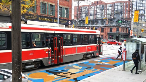
Proposed streetcar safety mural for King Street, Toronto.
(More) Plantings. Silver Spring is already marked by plantings, flowers in street medians, tree cover, etc. But there could be more. Sherwood High School has a Future Farmers of America program including horticulture. Perhaps somehow their program could be integrated into an expanded planting-greening program for Silver Spring.

Street furniture. Add as needed throughout the district, not just on and around Ellworth Avenue and Veterans Plaza. Don't install sub-standard street furniture. Push the design envelope by incorporating design forward examples, such as the Flower Chair from the Australian-US firm, Street Furniture.
Bus shelters. Silver Spring has a fair number of ordinary bus shelters. Besides ensuring that the shelters do the best possible job marketing transit, in keeping with the designation of the area as an arts district, bus shelters in the district should be remade as artistic elements of the public space.
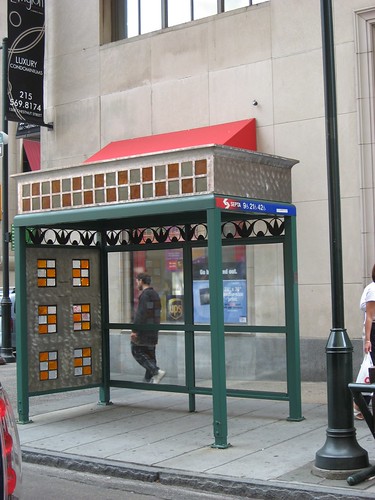
Art bus shelter in Philadelphia.
In terms of non-art improvements to bus shelters, Singapore ("Jurong bus stop makes waiting fun," Straits Times) and Dubai ("RTA constructs 100 air-conditioned smart bus shelters for Dubai commuters," Emirates 24 News) are doing interesting experiments with improving bus shelter environments too, some of which are worth considering.
(More) Public art. There are opportunities for sculptures, even an annual sculpture program like Sioux Falls, South Dakota (SculptureWalk | Downtown Sioux Falls), light projections, murals, a video screen for digital art and community messages at the Silver Spring Public Library, "complementing" the advertising-oriented video screen at Ellsworth and Fenton, etc.
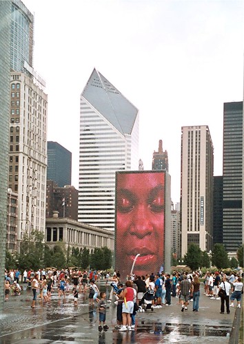
Crown Plaza Fountain, Chicago, with video projection by Jaume Plensa. Rather than this, think setting up the Fenton Street/Wayne Avenue edge of the Silver Spring Library as a digital screen.
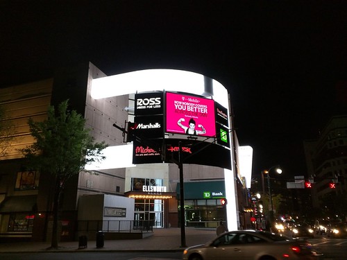
The advertising screen at the northwest intersection of Ellsworth Avenue and Fenton Street, on the facade of the Ellsworth Place shopping center. Photo from the East MoCo blog.
Architectural lighting. The canopy at Veterans Plaza is lit at night and there is a video ad screen across the street. One edge of the Discovery Building has a changing color light display.
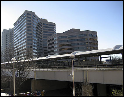
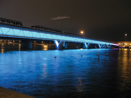
Silver Spring Metrorail Station platform-bridge-underpass
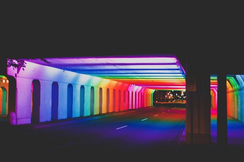
The canopy at the Metrorail station and underpasses could be similarly lit, like the light rail bridge in Tempe by Buster Simpson or the Birmingham Light Rails underpass by Bill FitzGibbons.
Tempe
Birmingham, Alabama
Muralizing the rail bridges. An alternative to doing a light treatment of the railroad bridges could be painting a mural across it, such as at the Silver Spring Metrorail Station. One way would be to extend the current mural by Sally Callmer Thompson to the bridge overpass. (The underpass on Georgia Avenue is adorned with a tile mosaic.)
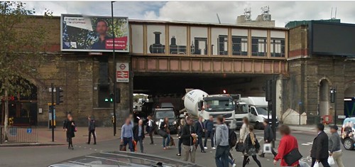
Mural of historic train on a bridge at the Vauxhall Underground Station, London

Wayfinding signage. A block by block wayfinding program, modeled after Alexandria's, should be employed on the main streets.
The Alexandria program uses four-sided signs, affixed to light poles. Two sides have block maps, one for each direction, plus the sign lists major destinations and how far they are at the top. The other sides address history, one side shows a historic photo, and the other includes text and photos on particular topics. The Alexandria signs don't show individual businesses, which would be a useful addition to the system.
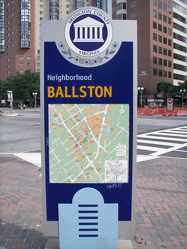
Arlington also has gateway marker map signage denoting its major districts, such as Ballston. There should be a sign like this outside the Metrorail station and in other "crossroads" locations.
This can also be done digitally. See item #10 below. And the two systems can work together.
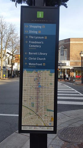
Map panel, Alexandria wayfinding system, southwest corner of Washington Blvd. and King Street
9. Create and implement a more wide ranging set of programming. The main point in the original piece on Silver Spring and layering is that the various spaces across Silver Spring should be managed as a network, and include programming where appropriate. This item proposes managing and programming across the network of spaces and places.
-- Silver Spring Events Calendar
Ellsworth Avenue and Veterans Plaza are highly programed. Ellsworth Avenue between Georgia Avenue and Fenton Street is a one block "pedestrian mall," with many scheduled special events and programs, including a Saturday Farmers Market, and a splash fountain for kids. Note that the Civic Building is also an indoor event space for public and private events.
While even the anchor spaces have opportunity for improvement, for example how the Boulder pedestrian mall is highly managed (2005 blog entry) and the Civic Building Exhibit Room should be more actively programmed, it's the spaces elsewhere in Silver Spring that need greater attention.
Not that every moment should be programmed. The strength of Ellsworth Avenue and Veterans Plaza is that a lot of the time they are unprogrammed, and used informally, where people do whatever they want, and into the evening hours--which is unique in the region.
People gravitate to the area, set up tables for chess, microphones for "spoken word" performance, just hang out, etc.
The idea is to add programming by filling in gaps within the current spaces----as well as at the currently underutilized spaces elsewhere in the district.
In terms of new programs in other spaces, one idea would be to set up a "summer beach" at the Silver Spring Transit Center, like the temporary beach set up in a parking lot at the Rockville Town Center last weekend.
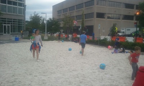
This would have been even cooler with some beach furniture--tables, chairs, and umbrellas.
It could be accompanied by a more formal pop up ("beer") garden, like the ones done by the Philadelphia Horticultural Society. Besides plantings, and the "beer garden," PHS programs the spaces with "educational gardening workshops, family-friendly activities, live entertainment and special events."
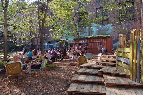
Pop Up Beer Garden, Philadelphia Horticultural Society
Another might be outdoor "Reading Rooms," like the one at Bryant Park in Manhattan, at the SSTC, Veterans Plaza, and outdoors at the patio of the Silver Spring Library, etc.
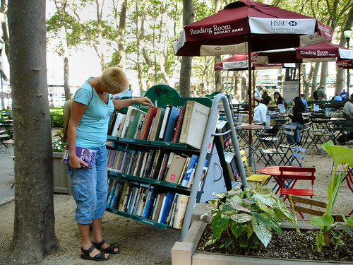
Bryant Park.
It would be so cool to have a transit-oriented "reading room" at the SSTC, with trade publications like Metro, Mass Transit, and Progressive Railroading, Trains Magazine, Railway Gazette International, Metro Report, newsletters from organizations and fan groups, etc. Or an outdoor reading room devoted to 'zines like the special zine collection at the Great Park in Irvine, California. Or a reading rack of art and media related publications including Art Newspaper, BookForum, Art Forum, Billboard, Print Magazine, Communications, Variety, etc.
The Parks Department has created a pop up activities program, which could develop a more formal set of programs for sites across Silver Spring.
The parking lot at the Park and Shop is sometimes used for events too. When space is at a premium, parking lots can be great programming resources.
Another example of extending "programming" would be to extend the hours of the Silver Spring Library, maybe just on Thursdays and Fridays initially, to 10 pm, as a way to improve access, to leverage investment in the facility, and to support the "night-time" activities within the district.
A more complete calendar of events and programs can be developed and communicated more widely as part of a digital community information network as described in item #10.
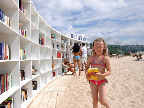
The very fun Beach Library in Albena, Bulgaria is another great example of thinking outside the "building" as it relates to programming.
Labels: branding-identity, city-regional branding, revitalization, transportation planning, urban design/placemaking
posted by Richard Layman @ 6:21 AM&Permanent Link
![]()
![]()


9 Comments:
Another programming idea, the equivalent of a "Doors Open" event for Silver Spring's cultural institutions.
http://www1.toronto.ca/wps/portal/contentonly?vgnextoid=42eafa2cd4a64410VgnVCM10000071d60f89RCRD
Crystal City does a weekly beer and wine garden on Fridays in the summer.
https://www.bisnow.com/washington-dc/news/neighborhood/crystal-citys-outdoor-beer-and-wine-garden-returns-74685
Of course, I am forgetting how hard core MoCo is about alcoholic beverage regulation...
Hill Country is back at National Building Museum too.
https://www.bizjournals.com/washington/news/2017/04/17/hill-country-barbecue-eyes-return-to-national.html
FRED is successful, will be expanded:
http://www.sandiegouniontribune.com/business/growth-development/sd-fi-free-ride-downtown-contract-20171114-story.html
11/16/2017
and I mentioned in the related entry, having a couple playgrounds in the core.
Walkable London proposal by Zaha Hadid architects, exhibit at New London Architecture
The section on sidewalks from the Boston Complete Streets Guidelines. Which includes a section on activation.
Active Design: Shaping the Sidewalk Experience
http://platformgezondontwerp.nl/onewebmedia/active_design.pdf
Ace Parking in San Diego says parking demand is down significantly, which they attribute in part to "ride hailing" services like Uber.
http://www.sandiegouniontribune.com/business/growth-development/sd-fi-ace-parking-uber-lyft-competition-20180222-story.html
I forgot the Promenade Fleuve Montagne program in Montreal, which I mentioned in the comments on the setting the stage piece.
http://www.cbc.ca/news/canada/montreal/promenade-fleuve-montagne-montreal-1.4208878
another way to think about improving the parking experience.
https://medium.com/@thisTenqyuLife/5-ideas-to-introduce-parking-as-an-experience-paae-b8e7c9bd6980
Savannah parking planning. Includes differentiated daytime and night time parking structure passes, and different rates for during the week vs. weekends.
Offer a dedicated senior shuttle service now. Thinking of converting to on-demand.
http://www.savannahnow.com/news/20180507/savannah-looks-to-app-based-shared-transportation-services-for-downtown-workers-seniors-as-part-of-parking-plan
5/8/2018
Post a Comment
<< Home