DC is a market leader in Mobility as a Service (MaaS)
Over the past few months, writing various pieces concerning various elements of sustainable mobility and what I am now calling the Sustainable Mobility Platform, I came to realize that while it has transpired incrementally, and while neither the industry nor the city planners may realize it, DC is a market leader in smart mobility/mobility as a service/transportation as a service.
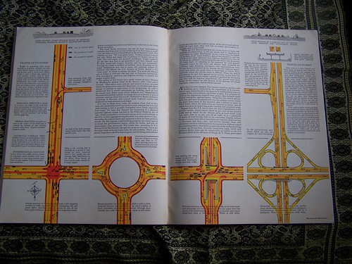
And so far, it has nothing to do with "autonomous vehicles." E.g., "How Driverless Cars Are Going to Change Cities," Wall Street Journal
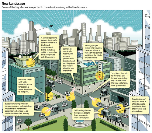
Changes in urban mobility infrastructure will come with driverless cars. Wall Street Journal graphic by Peter and Martha Hoey.
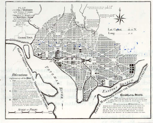
A lot of it comes from leveraging the urban form of the city--the grid of blocks and streets bisected by radial arterials.
This is the benefit of the L'Enfant Plan, laid out during the era of the "Walking City"--which bequeathed to the city an urban design that fosters the use of sustainable modes--first walking, then transit, then biking, the short distances between residential areas and employment centers, overlaid by a heavy rail and bus-based transit system.
-- "Transportation and Urban Form: Stages in the Spatial Evolution of the American Metropolis," Peter Muller
While the metropolitan area has access to many MaaS services, DC is premier because of how the services are layered and intertwined by users within the city and as a result it comprises a deeper and broader service platform within the city, enhanced by the city's urban form.
DC is the MaaS superstar, not the Washington Metropolitan area.
However, Bethesda and Silver Spring in Montgomery County, the Rosslyn-Ballston corridor and Crystal City in Arlington County, and probably a couple districts in Alexandria possess similar characteristics or have the potential, although not to the same degree of breadth and depth.
In presentations on bike planning, I make three related points:
1. Mobility is a system. And just like we built a system to support driving, we need a similar kind of deep system to support biking, if we want high usage, like in European cities like Copenhagen.
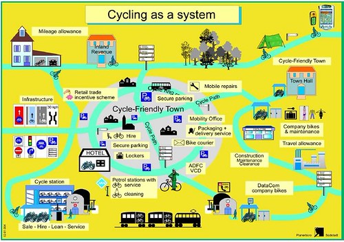
Bicycle Traffic as a system, diagram, German National Bicycle Plan, 2002-2012
2. While the US land use and transportation system preferences automobility, it took 60+ years to build the system that supports it.
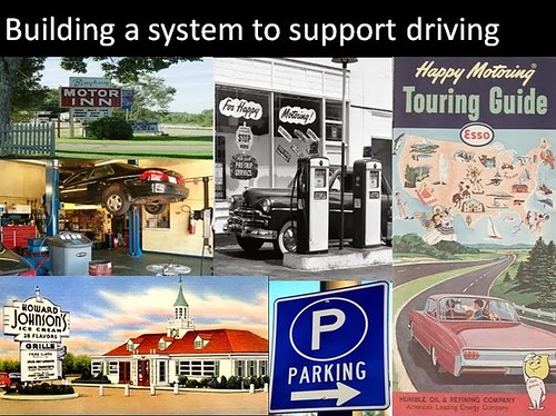
From my presentation "Best practice suburban bicycle planning".
Fortune Magazine, August 1936, article on how to create a highway system.
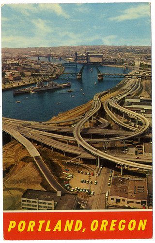
3. As an example of the length of time required to create successful new mobility environments, the sustainable mobility environment present in today's Portland, Oregon has taken 50 years to construct.
When people look to Portland, Oregon as a sustainable mobility leader and lament that their own community isn't comparable, they fail to recognize that the sustainable mobility platform in Portland present today has been constructed out of both incremental and visionary decision making that has built and reinforced the platform, starting in late 1960s ("A summary of my impressions of Portland Oregon," 2005) with the first decision, to demolish the freeway along the waterfront.
This is not the image of what people think when they think about Portland today. But it was accurate until the very early 1970s.
The move to mobility as a service is mostly a big city phenomenon, and even so, most big cities aren't well positioned to prioritize and preference sustainable mobility/MaaS.
When it comes to smart mobility/MaaS, DC is and in fact has been a leader, at least in North America, even if the system is being developed more incrementally and less purposively.
(I'd say that Seattle is co-equal to DC, except that DC is ahead when it comes to having a heavy rail system. Arguably, Seattle has a better bus system. Its stored value transit card is a bit more versatile and they have water-based transit services too. Community Transit, serving Snohomish County with service to Seattle, uses some double deck buses. And their area MPO is more innovative.)
The components of DC's Shared Mobility Platform/MaaS environment

1. Multi-modal transit system (Metrorail, 1976). DC had train service, streetcars dating to the 1860s (and ending in 1962), buses.
The Metrobus system was created out of local transit lines that went bankrupt, a few years before the then under construction Metrorail subway system began operating in 1976.
The Metrorail system now has 6 lines and 102 stations serving DC, Maryland and Virginia.
42 stations serve DC and 31 stations in the core of the city form a kind of "monocentric system" for DC proper, comparable to the MUNI system vis a vis BART in San Francisco, within the polycentric transit system that is Metrorail.
That sub-network is bounded by Foggy Bottom on the Southwest, RFK on the Southeast, Navy Yard and L'Enfant Plaza on the South, Van Ness on the Northwest and Brookland on the Northeast.
It's no surprise that not only is that section of the city the most prosperous, much of it includes the original L'Enfant City, for DC it is quite populous, and has the shortest distances between residential and activity centers.
Area jurisdictions also have their own bus systems. Montgomery County's RideOn system is considered a national best practice for suburban systems. Maryland took over commuter railroad services in the 1980s from Conrail and in the 1990s, Virginia launched the Virginia Railway Express. Both systems focus on bringing commuters into Washington, but at least with Baltimore, there is some reverse commuting.
The railroad services were Monday-Friday services, although in December 2013 MARC added weekend service to the Penn Line.
 WMATA is unusual in that it charges fares by mode. A trip with both subway and bus legs is two fares, with a slight discount. (Although bus to bus transfers, even between systems, are free.)
Two stations extended the blue line further into Maryland and opened in early 2004 while an infill station on the Red Line was built in DC's NoMa district and opened later that year.
Separately, Maryland is building a light rail system in Montgomery and Prince George's County that will intersect with Metrorail and MARC and open in 2022.
An extension to the Silver Line with 6 stations including service to Dulles Airport will open in 2020. An infill station is being developed for the Potomac Yard section of Alexandria and will open in 2022.
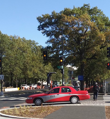 2. Taxis. In various forms, taxis have served DC for more than 150 years.
 For a long time DC used a flat rate zone fare system preferencing short trips in the core. Under the zone system, taxis could carry separate parties and charge each a separate fare.
In 2008, they switched to a distance based system and could no longer take multiple fares in a single trip ("D.C. Cabs Told to Switch From Zone Fares to Meters," Washington Post). With the change, taxis were also required to accept credit card payments.
Unlike many cities, DC does not charge "medallion fees" to own/operate a taxi so the barriers to entry were few, although taxi licensing is not unlimited and there are periods when the city does not issue new licenses. In 2012, DC City Council passed a law requiring that all taxis display a red-based color scheme, similar to the DC Circulator bus.
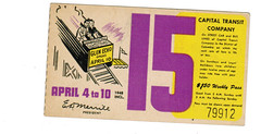
The DC streetcar system sold weekly transit passes. The story is that on weekends, parents would give them to their children for them to use.
3. Discounted transit passes. Compared to other metropolitan areas, monthly subway passes are quite expensive in the DC area. But bus passes are a bit cheaper than 10 fares, and include reciprocal use of local transit services. MARC train passes are a good deal and include free bus transit in Montgomery County and DC and free local transit in Baltimore.
DC supports a Youth Transit Pass that covers Metrorail. Metrorail also offers a discount pass for seniors.
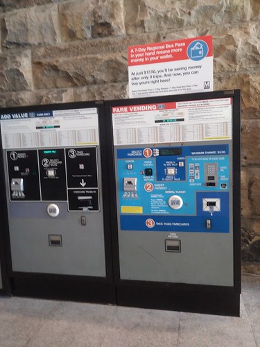
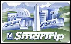 4. Stored Value Transit Fare Card (1999). SmarTrip card was introduced by WMATA in 1999, first for subway, then bus (2002) and parking (2004).
Over time, most area transit agencies (not railroads) have moved to the system. The Baltimore area adopted a branded version called CharmCard in 2010.
Money is added to the card at machines, online, or at certain stores set up with the proper equipment.
It hasn't been integrated with non-transit modes, although in Montreal, the STM transit agency has integrated bike share access and car share access into their fare card system.
In London, the Oyster Card can be used on local and commuter railroads and on ferry services. Seattle's card can be used on ferry, water taxis, and railroads. In SF Bay, on ferries and trains too. There, the fare card system is run by the local transportation planning organization, not a transit agency.
Recently it has been reported that DC and Baltimore area transit agencies are looking at bailing on the SmarTrip system because of problems dealing with WMATA ("Greater Washington Partnership issue brief on mobility (transit) fare systems," 2018).
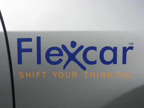 5. Two-Way Car Share (2004). Around 2004, the Flexcar and Zipcar car sharing services entered the DC market, starting out in Arlington County.
Members reserve cars in advance and access cars through smart cards and wireless telecommunications connections.
Payment is made through a credit card connected to the account. Users pay sales tax of 10% on each trip.
Two-way car sharing requires that you keep/pay for a car for the entire trip without relinquishing control of the car and it must be returned to the same place where you picked it up.
Zipcar created a preferred vendor relationship with WMATA putting cars at Metrorail stations. (Enterprise later bought that privilege.) Cars are available from a variety of locations throughout the city (and elsewhere in the metropolitan area), some on the street, some on private property. The Zipcar fleet has a variety of vehicles including pickup trucks and vans, to accommodate a range of trip needs and types.
Public participation processes were required for the authorization of the use of public spaces for this "private" service ("The high cost of free parking and car sharing in DC," 2005).
Flexcar and Zipcar merged in 2007. Zipcar was acquired by Avis Car Rental in 2013. Other companies, Enterprise and GM-owned Maven, have since entered the DC market, but Zipcar remains predominant.
For some people, two way car share substitutes for traditional car rental. Over time, special rates for all day, multiple day, and overnight use have been added, as well as customer benefits in association with participating retailers.
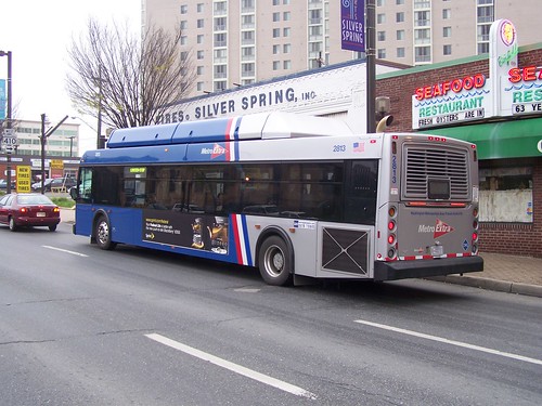
6. DC Circulator Bus (2005)/Metrobus limited stop bus services (2007). For decades, Metrobus has provided high frequency service for almost 24 hours on a number of DC routes on key arterials such as 16th Street, H Street/Benning Road, and Wisconsin Avenue, although these routes aren't called out as a high frequency network the way that Portland or Minneapolis brands such routes. The high frequency routes each serve 13,000 to 25,000 riders per day.

The concept is that the headways would be so frequent a posted schedule wasn't needed.
The DC Circulator service started out with Van Hool buses, which were "cooler" than the clunkier buses used by WMATA, done up in a more forward design scheme. The fare is $1, now half the cost of a Metrobus fare. And now the Circulator uses the same buses as Metrobus, but with the Circulator livery.
Over time, bus routes have been added to the Circulator system in farther reaches of the city, and routes outside the core tend to be less efficient in terms of usage and cost.
 In 2007, Metrobus introduced the first limited stop "faster" bus service on Georgia Avenue, the Route 79, called "MetroExtra." The buses are blue, as opposed to the red buses that denote they serve all stops. Subsequently, similar routes have been introduced to other lines.
7. Transit information displays and apps (2009/2010). Metrobus introduced NextBus real time bus information via phone in 2009.
While still not implemented in a systematic way, in 2010, DDOT introduced a pilot digital transit information screen, similar to a setup previously deployed by Arlington County. Since then, others including the independent firm TransitScreen has developed and deployed similar products, in DC and elsewhere.
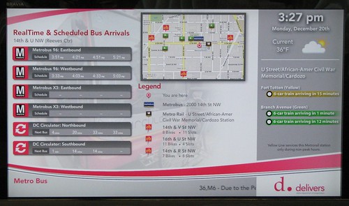
This is an area with a great deal of opportunity for growth. Screens with this information can be displayed in office building lobbies, at bus stops, in restaurants, etc. Geographically-set apps can display the screen on computer screens and smart phones.

Real time transit information via TransitScreen and the Orange Barrel Media digital billboard outside Capital One Arena, on 7th Street NW in the Gallery Place neighborhood. August 2017.
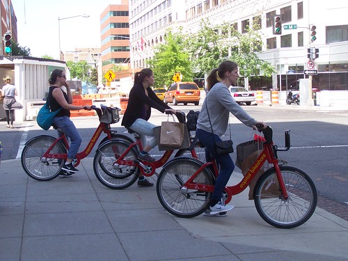 8. Dock-based Bike Share (2010). While an earlier pilot (2008) had been done with Clear Channel, the bus shelter contract did not require a rollout of bike share across the city and it was a 10 station system, hardly widespread.
 Instead of renegotiating, DC partnered with Arlington County and launched a different system in September 2010, called Capital Bikeshare, based on solar-powered equipment developed in Montreal.
Originally, members needed a key fob to access the system.
(One of the problems with the Clear Channel system is that it used hardwired electricity connections, which made the system more costly and much slower to deploy.)
Membership includes unlimited rides for no additional charge provide that the trip is less than 30 minutes. Longer trips trigger additional fees.
An undiscounted membership is $95/year and monthly and shorter term periods are also available. Later the additional fee structure was changed to reduce the cost for annual members, and a single trip option for $2 was added. The bulk of operating revenues come from fees charged to short term users.
Over time, the system has expanded to Alexandria and Montgomery County, and soon Prince George's County.
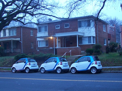 9. One-Way Car Share (2011). Car2Go, using small cars, introduced one-way car share to DC. Rather than in half hour increments with a one-hour minimum, cars are charged by the minute. Users are also charged sales tax on each trip.
Over time, a per trip fee was added and in 2015 the system switched from a card-based access system to smartphone-based systems. Payment is made by credit card connected to the account.
Paying a hefty access fee per car to the city means that the cars can be parked in most legal spaces, even resident priority areas and at meters without having to pay for no extra charge. In 2014, Car2Go service was extended to Arlington. In 2016, cars could be driven from one city to the other and left in either zone. 2017, Mercedes vehicles were added to the fleet.
 The advantage of the smartcars is that they are super easy to park in an environment of constrained parking supply.
To be competitive with one-way car share, Zipcar added "free parking" on DC streets to its service in 2014 ("Car Share Users Guaranteed Free Parking on D.C. Streets," NBC4). Zipcar introduced a clunky form of one way car sharing in 2016, but dropped it earlier this year ("Zipcar drops one-way rentals in DC region," WTOP radio). Unlike Car2Go, Zipcar still uses card-based access systems.
Car2Go home zones only cover DC and Arlington County, so cars can only be used one-way when driving in those areas.
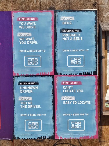
10. Ride Hailing (2011). To me, ride hailing is no different than a taxi. That being said, app-based ride hailing services utilizing a mix of professional and nonprofessional drivers, using personally-owned vehicles, were pioneered by Uber and Lyft. Uber argued that somehow because they used a phone-based app system that it wasn't a taxi and shouldn't be regulated. In many communities they won that argument. Dispatching and payment is handled through e-commerce solutions.
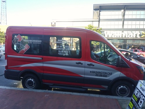 DC Government supports a taxi-based microtransit service in some portions of the outer city.
11. Microtransit services (2015/2016). Microtransit is the term now being used to refer to small-scale, sometimes on-demand jitney or "shared taxi" services.
STM in Montreal, and other communities in Quebec have offered shared taxi services for decades, in certain parts of its territory, usually at the edges, where traditional fixed route transit service isn't cost effective or doesn't meet the needs of its riders. Other communities in Quebec also
Most other transit systems in North America do not provide similar services. A number of for profit services were launched, focusing not on distant areas, but in core areas, but most (Split, Bridj) have failed.
Elsewhere, Ford continues to own one service called Chariot, and UberPool, LyftShuttle and the Via service remains operative in cities like New York and Washington DC. Payment is app based.

My sense ("Where's the revolution?: Bridj microtransit service shuts down (a/k/a "Mobility as a Service")," 2017) and not only mine ("Microtransit: What I Think We Know," Human Transit) is that core-focused microtransit services will fail as people will have to pay a premium price for short trips, and this isn't economically viable, nor is it justifiable for such trips to be subsidized by transit agencies.
However, contracted out "shared taxi" services comparable to those of STM, serving transit systems and riders on the edges of service areas likely have upside but will require subsidy ("Beyond the Bus: 'Microtransit' Helps Cities Expand Transportation," Governing Magazine). In 2016, working with taxi companies, the city launched a microtransit service operative in some wards called the Neighborhood Ride Service. This service is more comparable to services in Montreal and is focused on parts of the city outside of the core.
In 2018, Via introduced a new membership program including four rides/day and access to dockless bike share for $159/month.
12. DC Streetcar (2016). The streetcar isn't particularly noteworthy yet, but it adds another mode to the city's transit mix. So far, the line is truncated, 2.2 miles long, serving H Street NE with a connection to Union Station. The line is supposed to be extended east and west to Georgetown and perhaps Rosslyn, which would make it much more useful.
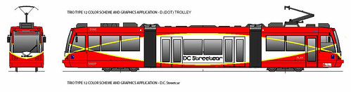
Presently, it's free to ride and advocates could use that as a way to press for the creation of a "fareless square" type of operation in the city ("Is making surface transit free the best transit investment DC can make?," 2015).
Unlike Kansas City ("Kansas City Tries to Go from Smart Strip to Smart City, Digital Trends), the streetcar hasn't been used to "drive" "smart city" improvements in that transit corridor or across the city.
I argue that such services need to be thought of as "intra-district" services ("Making the case for intra-city versus inter-city transportation planning," 2011). Instead, streetcars are often compared to longer route services and found wanting.
13. Metrorail stops using paper farecards, shifting to exclusive SmarTrip usage (2016). The system stopped issuing and accepting paper farecards, although cash can still be used on buses, but is discouraged in favor of the SmarTrip card. This doesn't speed up Metrorail but does reduce the cost of processing payments, and strengthens the use of the stored value transit fare card as a primary MaaS payment device.
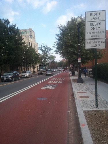 14. Dedicated bus lanes (transitways) painted red (2016). Exclusive bus lanes painted red were introduced to a section of Georgia Avenue ("Georgia Avenue boasts bright red bus lanes," Washington Post).
Into the 1970s, the area had a number of dedicated busways, but over time they were removed. Earlier in the decade an exclusive bus lane was installed on 7th Street NW but it isn't painted red and there is minimal enforcement. More dedicated transitways are in planning.
Making bus service faster through transitways increases throughput and is the equivalent of adding new bus trips to the service. The red paint makes this noteworthy and worth listing as a MaaS element as would other bus prioritization initiatives such as traffic signal preferencing (in place for the DC Streetcar, but not buses).
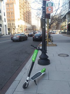
15. Dockless bike share including e-bikes (2017). Dockless bike share was introduced on a pilot basis last fall. Multiple firms, some from China, are involved in the business.
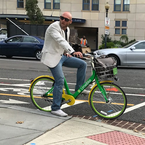 The original trial period which was to end in April, has been extended. The advantage of dockless is like one-way car share, it is point-to-point and you can leave the bike "anywhere," including right at the endpoint of your trip.
Riders join the system through an app, which is used to pay for individual trips through a credit card link.
Interestingly, these services mostly charge per ride, $1, but $2 for the e-bike from Jump, so that regular riding would cost significantly more--ten times more or higher--than traditional dock-based bike share and at least 3 times higher than the cost of buying a bike. Likely such systems only appeal to occasional users.
They are only cheaper to use when compared to a transit ride, which is $2-$4 on a single trip basis.
Given that dock-based systems were developed for bike share in response to vandalism and theft experienced with early versions of what we would now call dockless bike share, not surprisingly many of the bikes have been vandalized ("Theft and destruction of dockless bikes a growing problem," Washington Post). And many bikes are improperly parked.
To compete with Jump, which was recently acquired by Uber, LimeBike added e-bikes in 2018. Note that e-bikes are overkill in the core of the city, but make sense in the outer city ("(Still) tired of mis-understanding of the potential for e-bikes," 2015).
 16. Dockless e-scooters (2018). Bird, a company focused exclusively on dockless scooters, introduced e-scooters last year in Santa Monica, and after raising venture capital to fuel expansion ("Dockless scooters as an example of a lot of money sloshing around in venture capital," 2018), they and LimeBike, which added e-scooters to their program, launched e-scooters in DC in late Spring.
 There is a flat fee of $1 plus a per minute use charge. (Spin is also getting into the e-scooter market.)
E-scooters may have some advantages over bikes because they are faster and people believe they are trendy when they ride them ("The invasion of the scooter bros: A new tribe," Washington Post).
17. Transit card only bus service (2018). Route 79, the first Metro Extra limited stop bus route, has just shifted to a card-only usage profile, no longer taking cash fares ("Metro's cash-free bus pilot aims to speed up trips, but some riders worried," WTOP-radio). This is to speed up boarding. (DC buses still do front-door boarding exclusively).
Surely this is a pilot with the hopes of being able to do this across the system. But in order to do so, WMATA needs to make it a lot easier for people to put cash money on the cards ("What's remarkable about this storefront?," 2018). I've thought for years they should put Metrofare machines in public places but that would create a security and collections cost problem.
The difference between the Sustainable Mobility Platform and Mobility as a Service. In my SMP framework, I list elements like Barnes Dance intersections and cycle tracks.
But Mobility as a Service is about trips, usually costing money. It's a sub-set of the SMP, not co-equal to it.
In this listing I did include items like transit information screens and transitways because they have a significant impact on the utility of certain services, or provide the kind of information that people need to make sense of their options.
Arguably, I could have included some other items. What have I missed?
The MaaS underlying infrastructure: streets and traffic signals + computing and telecommunications. One thing we don't think about is that almost none of this can work without roads, rights of way, and signaling systems. Those are controlled by local and state transportation departments. In DC, they are mostly controlled by the DC Department of Transportation, although here and there certain roads and signals are controlled by federal agencies such as the National Park Service.
They are the enabling/foundational infrastructure, coupled with high quality computing applications, telecommunications systems and cloud-based hardware systems, accessed by smartphones and other computing/telecommunications devices.
What's missing or problematic
Do we need a master app integrating all services? I don't think the lack of integrated apps pulling all the services together is a deal killer. If it were just public agencies, it might be possible to create a master app, like the Oyster card. But those are geographically bounded systems.
The for profit providers operate in multiple markets and it is less valuable for them to participate in regionally-specific fare systems. It's problematic for the user too, who wants to be able to use these modes in other places--e.g., I've used Car2Go in San Diego and Seattle and Zipcar in San Francisco and Seattle. Most Uber users use it when they travel, etc.
Nevertheless, area transit agencies must commit to using an integrated payment system. That being said, there should be one unified fare card system for metropolitan area transit agencies, and ideally it should be managed and supported by the metropolitan transportation planning organization. By shifting responsibility from WMATA to the Transportation Policy Board/Metropolitan Washington Council of Governments, perhaps the current problems and enmity between actors can be assuaged.
The fare card system (recognizing its moving towards being exclusively contactless or including contactless options) should work diligently to include commuter railroad services. If London, Seattle, and San Francisco can do it so can other places, including DC.
-- "One big idea: Getting MARC and Metrorail to integrate fares, stations, and marketing systems, using London Overground as an example," 2015
Don't confuse tourist water transportation services with transit. The DC area has a developing water taxi system, but it's for tourists and shouldn't be represented as transit. That being said, it's worth integrating the service into the SmarTrip system as one element in moving towards adding water-based transportation services to the transit mix.
Do you need a subscription covering all or a basket of services? Anyone out there wanting to pay almost $600/month to Whim? Whim, which started in Helsinki, is doing pilots in the West Midlands, UK, Antwerp, and Amsterdam.
To me, the point of mobility as a service is to pay less than you would if you owned a car, which is $7,000 to $9,000/year. Whim doesn't seem to provide much in the way of savings. I don't think the trade off of simplicity--using one app, is worth the loss of savings.

Gondola as a mode. The Georgetown Business Improvement District aims to create a gondola system to connect Georgetown to the Rosslyn Metrorail Station, thereby "capturing" that station and making it serve DC more directly despite being in Virginia, across the Potomac River, and accessible currently only by the traffic engorged Key Bridge ("The case for the Georgetown-Rosslyn gondola").
Interestingly, the gondola service is more important for night-time and weekend transportation, not for day-time commuter use, although that would be served by the mode as well.
That would extend the transit network/MaaS/SMP.
==========
Writing all this, I still haven't read the various Los Angeles DOT reports on MaaS. That city aims to be a leader in the field.
-- Strategic Implementation Plan: A Plan to realize the visions outlined in the Urban Mobility for a Digital Age and Blueprint for Autonomous Urbanism document, Los Angeles DOT
-- Urban Mobility in a Digital Age, Los Angeles DOT
-- Blueprint for Autonomous Urbanism, National Association of City Transportation Officials
Labels: intelligent transportation systems/ITS, mobility as a service (MaaS), sustainable mobility platform, transit, transportation as a service (TaaS), transportation infrastructure, transportation planning
posted by Richard Layman @ 4:51 AM&Permanent Link
![]()
![]()


7 Comments:
Honestly, smartphones have made much of the unified payment this obsolete.
I use my phone on car2go, no idea where the physical card is. I think the CABI app now allows you to generate codes rather than having the key. Zipcar is still very tied to a key.
And MAAS isn't going to be cheap. Hence the 600/m price tag. If you want to be cheap buy a bike or a scooter or a car.
So I'd hope you's push for a more aggressive think piece on what is MAAS and not your best practices list. You need to own this term.
And I'd frame it as JJ old adage of cities as innovation machines -- that after 70+ years of car centered thinking cities can create a new way of thinking about moving on.
The pubic policy challenge is how to deepen MAAS and get new entrants (hint, visitors), how to tax it, and to manage it so it benefits a city (all this uber traffic is actually really bad).
DC now as rideshare police out there monitoring behavior. Likewise we need investments in new cameras that can do more than detect speeding and running red lights.
I agree about smartphones. Comfort with using all types of apps means having an integrated payment system doesn't matter so much.
You're right I still need to think about this stuff more deeply.
WRT "cameras" I was grappling with the infrastructure and what I call the Sustainable Mobility Platform and the separate MaaS.
While writing this piece, I went back and added a few items to the SMP, e.g., a section on Transportation System Infrastructure (but other items too, like congestion zones).
But rather than specifically id cameras, sensor networks etc. one of the elements is ITS initiatives.
WRT your general point, that's the kind of thinking embedded in the LA DOT documents, and articles like the WSJ "Future of Cities" special section. Politico Magazine too, the current issue is on mobility, although I haven't cracked it open yet.
https://www.bloomberg.com/news/articles/2018-07-15/how-helsinki-arrived-at-the-future-of-urban-travel-first
Look, I'd say this is more a consequence of bigger trends (smartphone, ubiquitous data, cheap+decent quality Chinese electronics, gas prices, millennials) that are converging rather than a conscious effort by city planning.
The goals for city planners is how to use this.
Hence why it happening in DC first -- urban form is creating the space for innovation.
Yes, Yes, Yes, Yes, Yes, Yes, Yes, Yes, Yes.
That's the struggle in writing about this.
The reality is the best trip is the one you don't need a vehicle to take, or is so optimized that it isn't a big deal.
It's the combination of urban form, compactness, density. In short, all that Jane Jacobs wrote about.
Helsinki maybe was "first' in terms of coming up with uneconomic approaches in putting it all together.
But that isn't what's most important. It's the layering of services that people can put together themselves.
... I mention Muller all the time. Basically DC was designed in the era of the walking city, a design equally supportive of biking (especially because of radial avenues) and then transit.
It's either for efficient single journeys or many journeys massed together on transit.
It doesn't work well for single journeys in vehicles.
That's why ride hailing "is bad". It induces demand of a mode that is inefficient at the system scale. (Again, getting back to my overarching point that we shouldn't be focused on maximizing choice, a neoliberal argument btw, but on maximizing optimality.
But for transit to work at longer distances you still need mass and network breadth.
I am reading "Frank Pick's London" about his approach to developing the foundational approaches for London Transport.
Not only are the points still "fresh, evergreen, relevant" but it's amazing how much they've been blown off by newer agencies (e.g., WMATA). Pick realized the brilliance of the Underground was that it facilitated access to the city by all, that it enabled growth and development.
While reading it I was thinking about the "Marketing Myopia" piece by Levitt, that "GM is a transportation company and didn't think of itself that way" (not fully true, that wasn't their real problem, it was that they are a pension and health insurance delivery organization that produces cars, because of the way these services are delivered in the US).
But WMATA doesn't see itself as a "transportation company" but a rail operator that also has to do bus.
1. Pick always promoted the use of the Underground for "trips" at all times of day and night, on all days "for business or for pleasure."
2. When the company acquired the main bus line, which had promoted itself as competitive to the Underground "fresh air all the way on your trip", Pick realizing that bus and tram should be promoted as complementary elements of an integrated mobility system.
That the Underground moves the most people the quickest over longer distances, and buses and trams bring people to and from the Underground, from origin points and too final trip destinations.
===
Reading the section about getting the various then separate organizations started to develop not common fares exactly, but through trip ticketing, and the creation of a common map, etc. c. 1906, I was thinking, hmm, they have 60 years on HVV in Hamburg, which was the first to do this across different agencies and different modes in the modern era.
======
This comes back to different land use contexts having different opportunities with AV and MaaS.
I wonder if I have the imagination to think of how it can change things.
It will allow for more density, better use of space.
But will provide that density? It needs to be there to make the vision work.
.... London didn't have planning for land use and transportation til the 1930s. Indirectly, because of their understanding of strategic planning, and the link between ridership, growth,and "streetcar suburbs," the Underground was doing it by default.
The big change after the stored value card was first two way car share and then one way car share especially.
But without a "transport association" too often the services are seen and function as competitors.
when transit is a utility, "central to all things Washington," it is a different approach.
Pick wanted the system to be seen as dynamic, always improving. That comes in part from extensions, but also how they do everything else.
Most agencies don't live up to that. Granted these days extensions are very expensive.
Instead, we operationalize growth through the road network and then criticize transit for needing to be subsidized.
Subscription car use service in Philadelphia has problems.
Ardmore car subscription service Go abruptly cancels 300+ customers and demands vehicles be returned in 10 days
https://www.inquirer.com/business/go-ardmore-car-subscription-service-vehicle-recall-20230707.html
Imagine driving your car for over a year and making payments, just to be told you have 10 days to give it back. Hundreds of Go customers are scrambling after getting an unexpected letter from the Ardmore-based company. The long-term vehicle subscriptions were cheaper than buying or leasing and it was supposed to last for three years. The deal may have been too good to be true, and some customers are fighting back.
Thank you for sharing valuable information
contactless car rental pick up
Post a Comment
<< Home