Dedicated bus transitway on Georgia Avenue NW
Over the years I have commented on the chokepoint at the intersection of Georgia Avenue and U Street NW, where parking on the north side of the street interfered with traffic queuing for left turns on to U Street as well as the traffic seeking to continue through the intersection onto 7th Street.
Because many of the vehicles stuck in the queue are buses on the 70s line, this led to a significant delay in transit times on the 70s routes.
But recently, the DDOT removed that pesky lane of parking and changed the street configuration to provide a dedicated lane for sustainable mobility, primarily buses but also bikes.

Hopefully this will decrease the likelihood of "regular motor vehicle traffic" using the lane.
It seems to be working. I expect it will have positive impact on run times for the buses.
These elements are what separate this treatment from that on 7th Street NW in the vicinity of the Verizon Center. There it hasn't worked very well, in large part because of the lack of especial markings and the failure to remove street parking.
But also probably because there aren't that many buses using that section of the street, compared to Georgia Avenue.
Note that the major omission from my presentation on "Metropolitan mass transit planning" was the failure to suggest the need for a dedicated transitway network in the core of the city.
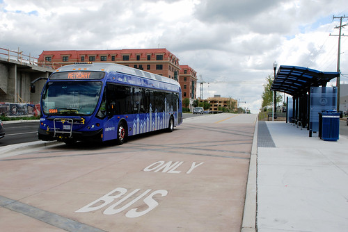
The Metroway bus line in Alexandria and Arlington, Virginia includes dedicated transitways. Photo by BeyondDC.
It turns out that in the 1970s a network of dedicated busways did exist in DC and Virginia.
-- "We had bus lanes a half century ago and we can again," PlanIt Metro.
Since then, for the most part these lanes have since been given back to cars.
Currently there are plans for dedicated transitways on K Street NW, in association with streetcar planning, and for dedicated busways at least at certain times of day, on 16th Street NW, for the S line, which is the highest used bus line in the city, with between 20,000 and 25,000 daily riders.

Busway map, 1976.
Historically, busways were recommended as a way to facilitate transit demand management, in the 1950 DC Comprehensive Land Use Plan.
For other ways to improve bus service, see "Making bus service sexy and more equitable."
Also:
-- "What we can learn from city busways," Atlantic CityLab
-- "Paris: The street is ours," Human Transit blog
Note that Chicago recently created a set of transitways Downtown, called the Loop Link ("Chicago's Loop Link not exactly rapid, but a step in right direction," Chicago Tribune).
Chicago Loop Link map

Labels: bus, busways/transitways, traffic engineering, transit infrastructure, transit marketing, transportation planning
posted by Richard Layman @ 2:41 PM&Permanent Link
![]()
![]()


0 Comments:
Post a Comment
<< Home