Revisiting: a proposal for heritage streetcar service on the National Mall | adding service to the DC waterfront

In 2013, as part of a more comprehensive approach to visitor services and visitor transportation in association with DC's place as a major tourist destination in the United States because it is the national capital, I suggested the creation of a heritage streetcar service on the National Mall, with a starting point at Union Station and an ending point at a proposed infill Yellow Line subway station across from the Jefferson Memorial, with service across the Potomac River to Arlington Cemetery and the Iwo Jima Memorial. But I didn't really think too much about the routing.
-- "A National Mall-focused heritage (replica) streetcar service to serve visitors is a way bigger idea than a parking garage under the Mall"
-- Department of Interior - Visitor Access and Transportation Guide, Volpe Center, USDOT
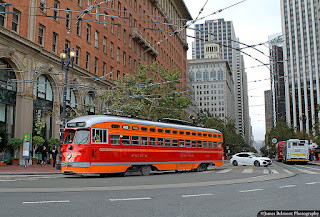
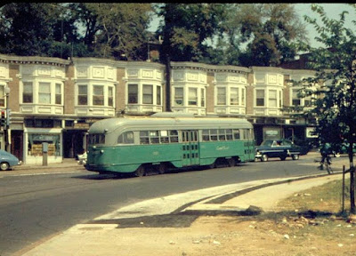
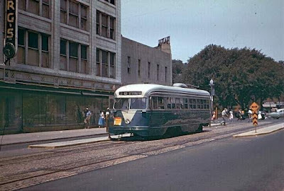
Using heritage cars was suggested as a way to build tourist interest as well as being modeled after San Francisco's Market Street Railway F Line, which runs heritage streetcars of all types, with liveries representing various historic transit lines from across the country which are no longer in operation.
Last time I checked, because of its novelty, the F Street Line had a 200% farebox recovery.
Later, with the re-institution of DC Circulator bus service on the National Mall, I realized that in terms of the National Mall, we think about accessing it from the east, from Union Station and the Capitol, but not so much from the west, in particular Georgetown.

So I expanded the concept with the eastern node at Union Station and a western node in Georgetown, with an intermediate node at the proposed Jefferson Memorial Metrorail Station but again, I didn't get into routing.
-- "New DC Circulator route serving National Mall reminds us that we are neglecting connections from west to east and fail to adequately connect Georgetown to the National Mall," 2015
-- National Mall maps and planning documents, National Park Service
Note that the NPS map, surprisingly, shows the route of the DC Circulator service on the Mall (but not for Georgetown).
Visitor services and the idea of an under the National Mall parking garage. Equal to the importance of the addition of transit was the creation of a set of high quality visitor centers, at Union Station, at the National Mall, at the proposed Jefferson Memorial Metrorail Station, and in Georgetown ("Today is World Tourism Day," 2016) as part of a broader city tourism development and management plan ("National Tourism and Travel Week 2019: DC recap | DC needs a tourism development and management plan," 2019).
And later I realized that the National Park Service ought to create an anchor visitor center of its own covering all of its DMV parks and sites (see item 6, "National Public Lands Day," 2021).
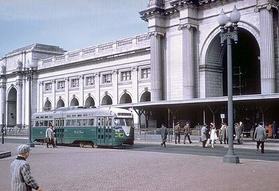
A railway and tourism museum at Union Station. Other writings suggest the creation of a railroad and tourism museum at Union Station, in conjunction with its expansion program (see the sections "More fully leveraging Union Station's potential as a portal and visitor center" and "Including a cultural interpretation element in the plan on railroad history and a museum-exhibiting program centered at Union Station" within "New State Rail Planning Initiative in DC," 2015).
Of course, a heritage streetcar system along the lines of the Market Street Railway is a form of open air museum too, and could be operated in association with the National Capitol Trolley Museum in Montgomery County.
Separately, I've suggested developing tourist rail services from Union Station ("Two train/regional transit ideas: Part 2 | Running tourist trains from Union Station," 2021).
Underground parking on the National Mall. And I am fine with the National Mall Coalition's proposal adding a big underground parking structure at the National Mall, including flood protections, to capture, interdict, and reduce visitor traffic, I just thought that it needed to be part of a bigger program ("Parking under the National Mall should be part of an integrated approach to visitor services and management," 2013).
In fact, given the increased severity of weather events in the face of climate change, implementation of this concept is even more imperative ("How and why the D.C. area was deluged by a month’s worth of rain in an hour Monday," 2019, Washington Post).
#DCsBravest have removed several occupants to safety from cars in high water at 15th St and Constitution Ave NW. pic.twitter.com/MKXSMJzsua
— DC Fire and EMS (@dcfireems) July 8, 2019
Transportation and the Wharf/Washington Channel/Southwest Waterfront. Will just sent me another article ("Here's What Next at DC's Wharf and Fish Market," NBC4) about transportation issues around the Wharf district, which is a rebuilding of old urban renewal along Maine Avenue SW.
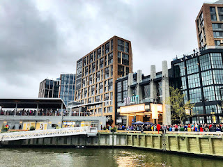
The first phase opened in 2017, and a second phase will open later this year. The second phase will add 1,000 more parking spaces.
The area is near the L'Enfant Plaza and 4th Street SW Metrorail stations and a free bus shuttle travels to the Wharf from the National Mall/L'Enfant Plaza.A long time ago, when DC had expansive plans for streetcar service, one of the planned lines was a Georgia Avenue/7th Street streetcar terminating at the Washington Channel's Wharf district on the Southwest waterfront--recreating the historic route that had its destination as the "Wharves," docks for steamboats and other ships.
But DC has pretty much given up much interest in streetcar expansion beyond H Street.
But as the NBC4 article discusses, there are many trips to the Wharf district, which will only increase as the second phase opens, and transit connections are somewhat inadequate, and there isn't enough "parking" either, were everyone to drive--and of course from a transportation demand management perspective, we want to discourage driving in the city as it promotes unnecessary congestion.
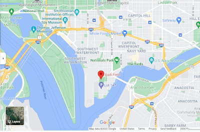
Adding a Southwest-Southeast Waterfront leg to the heritage streetcar visitor transportation proposal. Some thoughts about routing:
- The original concept starts at Union Station and travels down Louisiana Avenue to the National Mall.
- On the Mall, it would travel westbound on Madison Drive NW (the side of the Mall with the National Gallery)
- and on the return, eastbound on Jefferson Drive SW (the side of the National Mall with the Smithsonian Castle, Hirshorn, Air and Space Museum) and then crossing back to Louisiana Avenue and Union Station.
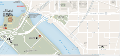
- At 14th Street/the area of the Washington Monument, westbound it would probably follow the routing of the Circulator to Lincoln Memorial (shown on the NPS map as a red hatched line)
- But I didn't figure out how it could travel from Lincoln Memorial to Georgetown and Arlington Cemetery
- It could cross into Arlington over the Memorial Bridge, serving Arlington Cemetery, traveling west to the Iwo Jima Memorial and then into Rosslyn, crossing back into DC, into Georgetown at the Key Bridge
- From Georgetown it needs to be routed back to Lincoln Memorial, with service to the Kennedy Center in Rock Creek Park
- Continuing eastbound from Lincoln Memorial, it would go over to Jefferson Memorial and the proposed Jefferson Memorial Metrorail Station.
- The Circulator does this by traveling through West Potomac Park, with intervening stops at the MLK and FDR Memorials, and from the Jefferson Memorial, back to the Mall providing intervening stops at the Bureau of Engraving and Printing and the Holocaust Museum
- From Jefferson Memorial it would return to the National Mall,
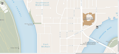
The NPS map doesn't specifically delineate the Wharf district or Audi Field, the stadium for the DC United Soccer team, although it does show the Nationals Baseball Stadium.

When the Nationals baseball stadium was first proposed, I suggested a straight line streetcar from Union Station to the Stadium, to provide a way to get people to the Orange/Blue/Silver and Red Lines and Union Station more directly ("Baseball World Series in DC #3: Five lessons for transit," 2019). The problem though is traveling through the US Capitol Campus, and their security issues.
Labels: car culture and automobility, cultural heritage/tourism, museums, streetcars, transit, transportation demand management, transportation planning, urban design/placemaking, visitor services
posted by Richard Layman @ 2:09 PM&Permanent Link
![]()
![]()


0 Comments:
Post a Comment
<< Home