The (Meta) Regional Transit Network and transportation "vision" maps
In other writings, I've conceptualized the regional transit network, but in the context of Washington, DC specifically. At one level this concept is normative, organized around local jurisdictions. At the same time, the transit network is regional.
And planning and service needs to be conceptualized and delivered using the transitshed and mobilityshed concepts that I have been developing for a couple years, first discussed in the blog entry "Relativistic thinking about mobility."
To make sense of all the various transportation visions that are floating around, it makes sense to add a meta- or super-regional dimension, which is helpful in considering the various transportation vision map proposals that are being offered by a variety of talented folks.
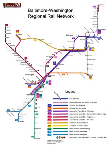
I am taking the liberty of reprinting the Regional Railroad map vision by Track Twenty Nine, which doesn't go far enough in my opinion, but of all the map designs out there, is probably the best designed. See "Regional Rail Redux," for railroads, and "You Might Say I'm a Dreamer..." for light rail, heavy rail, and streetcar (which is improperly labeled as light rail--there is a quantum level difference in how streetcar lines are operationalized with more stops and slower service vs. light rail lines).
Brian Robinson has also produced a transportation vision map, but in my opinion it's focused on heavier rail transit expansion in the suburbs, or at least, in the areas outside of the core of the Baltimore and Washington center city regions.
This is an important point because you need to balance use now and in the future, as well as the ability to utilize transportation to add density where appropriate, push forward revitalization objectives, and reshape mobility patterns, etc.
This is the core of BeyondDC's argument that the cost of heavy rail can be justified only where you will yield great usage and substantive improvements in land use that are able to be monetized.
He thinks, justifiably, that you can produce a lot more transit infrastructure (light rail, streetcar, decent bus service) for the same amount of money. And, that it's insane to spend money on heavy rail in areas where service objectives can be met by utilizing the railroad trackage (that often once was used for passenger service).
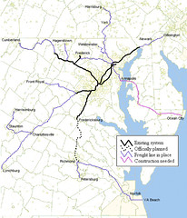
BeyondDC railroad trackage map.
Where you make the choice between one or the other has to do with demand, land use patterns, ability to shape a mobility framework independent from automobility-carcentricity. Except in the most specific of situations, it's hard to justify, given limited funds, spending the money on heavy rail.
And it's also tricky because if anything has been proven by the experience of "Transit Oriented Development" and "Development Oriented Transit" in DC and Arlington County, within a system that was conceptualized primarily as a Suburban commuter to the city and back home during the workday transit model, is that it takes a long time (a minimum of 20-25 years) to see significantly repatterning of development and transportation behavior--and that's in a strong real estate market and local economy.
With the case of DC, it would have taken decades longer than it has, without the fact that much of the city was planned and developed before 1920 when development patterns and urban design favored transit use. (E.g., try to repattern Charlotte, NC. It will take many decades.)
Remember that Belmont, in Cities in Full, justifiably criticizes transit systems like Washington's as promoting sprawl, because the system is polycentric and promotes diffusion rather than concentration of land use, and in the outer suburbs, is reliant on cars and other vehicles to move people to and from subway stations, and because except for work-trips, transit usage is low.
For this reason (polycentricity and sprawl), it's difficult to justify extension of heavy rail (WMATA) service to places like Howard County, because while on the margins it could improve things there, mostly it's about enabling and supporting sprawl. In any case, to justify heavy rail expansion to places like that, members of the WMATA Compact must demand that system operations cost increases be borne by the new areas, and the Metropolitan Planning Organizations and the Federal Government (if it cared about such things), would require that these communities create a linked land use and transportation planning paradigm and regime for land use decisions going forward, before funding would be committed to extending heavy rail.
On the other hand, expanding railroad service would be more cost effective for certain kinds of trips, and likely it would make more sense to develop a system of light rail lines for out-county areas that could hook into regional intermodal stations as part of a broader transit network. This would make more sense for cost reasons and usage reasons, as the number of trips going to Baltimore or Washington the farther you get away from the city drops precipitously--but the metropolitan regional networks are still focused on the central city.
This is what Paris has been doing, by adding light rail to less dense areas of the region on the outskirts of the city, complementing the extant subway and railroad lines.
The various light rail proposals in Maryland and Virginia, the Purple Line (Montgomery and Prince George's County, and in theory, could be continued west to Virginia's Fairfax County) and Corridor Cities Transit (Montgomery and Frederick Counties) proposals are similarly conceived in my opinion. These lines are subsidiary and complementary to the Washington regional network.
However, (and this is what I mean about normative consideration), in the Hampton Roads area of Virginia, because there isn't transit service available other than bus (and Amtrak service), the proposed PENINSULA RAIL TRANSIT PROJECT light rail project would comprise a core portion of the Hampton Roads Metropolitan (or regional) transportation network, in addition to cross-city and county bus services. In DC, this same project wouldn't be considered part of the primary network, although it would in the suburbs.
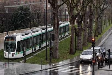
A tram from the new Parisian tramway is seen shortly after its inauguration in Paris, December 16, 2006. Trams returned to Paris on Saturday after a 69-year gap, with the inauguration of a new commuter service around part of the city's southern periphery. The 'Tramway of the Marshals' traces a five-mile (eight-km) arc along the southern perimeter, following a series of boulevards named after Napoleon's generals. REUTERS/Benoit Tessier (FRANCE)
To try to get the other transportation visionaries to start thinking on the same page, I offer a revised version of my earlier conceptualized transit network:
A framework for an all encompassing DC-MD-VA transit network
Meta (or Multi-state) Regional Transit Network: MARC and VRE service ideally combined into one multi-state compact and system, with service as far south as Norfolk and as far north as Wilmington, DE and Harrisburg, PA, and west to Charlottesville, VA (or beyond), with intermodal stations connecting to heavy and light rail transit systems; supplemented by Amtrak. This could include railroad and water-based transportation.

(The model is the LIRR and Metro-North railroad system in the New York City region, which is managed by the Metropolitan Transportation Authority of New York, and runs 24/7/365.)
Washington Regional Transit Network: Regional WMATA subway system; ferry system if added; cross-jurisdictional bus rapid transit; commuter services oriented to moving people between the jurisdiction and major job centers within the region, across jurisdictional boundaries (i.e., OmniRide from Prince William County, which provides commuter-oriented service to Metro stations and job centers, with an end point in DC [and back] or the MTA Commuter buses).
Suburban Primary Transit Network: transit systems operated by Counties and Cities in the Washington region providing bus, streetcar, and lightrail service within the suburbs, and connections to stations within the regional transit network. Transit service in this category is classified by speed and destination.
 Montgomery County's RideOn bus system is one of the more successful suburban transit systems in the United States. I don't think it provides cross-jurisdictional service, other than service along Western Avenue (which technically is 100% in DC), maybe Eastern Avenue, and to the Takoma Metro station and in the Langley Park area of Prince George's County. Photo from BeyondDC.
 Rendering, streetcar service on Columbia Pike, Arlington and Fairfax Counties, Virginia.
On the other hand, expanding railroad service would be more cost effective for certain kinds of trips, and likely it would make more sense to develop a system of light rail lines for out-county areas that could hook into regional intermodal stations as part of a broader transit network. This would make more sense for cost reasons and usage reasons, as the number of trips going to Baltimore or Washington the farther you get away from the city drops precipitously--but the metropolitan regional networks are still focused on the central city.
This is what Paris has been doing, by adding light rail to less dense areas of the region on the outskirts of the city, complementing the extant subway and railroad lines.
The various light rail proposals in Maryland and Virginia, the Purple Line (Montgomery and Prince George's County, and in theory, could be continued west to Virginia's Fairfax County) and Corridor Cities Transit (Montgomery and Frederick Counties) proposals are similarly conceived in my opinion. These lines are subsidiary and complementary to the Washington regional network.
However, (and this is what I mean about normative consideration), in the Hampton Roads area of Virginia, because there isn't transit service available other than bus (and Amtrak service), the proposed PENINSULA RAIL TRANSIT PROJECT light rail project would comprise a core portion of the Hampton Roads Metropolitan (or regional) transportation network, in addition to cross-city and county bus services. In DC, this same project wouldn't be considered part of the primary network, although it would in the suburbs.
A tram from the new Parisian tramway is seen shortly after its inauguration in Paris, December 16, 2006. Trams returned to Paris on Saturday after a 69-year gap, with the inauguration of a new commuter service around part of the city's southern periphery. The 'Tramway of the Marshals' traces a five-mile (eight-km) arc along the southern perimeter, following a series of boulevards named after Napoleon's generals. REUTERS/Benoit Tessier (FRANCE)
To try to get the other transportation visionaries to start thinking on the same page, I offer a revised version of my earlier conceptualized transit network:
A framework for an all encompassing DC-MD-VA transit network
Meta (or Multi-state) Regional Transit Network: MARC and VRE service ideally combined into one multi-state compact and system, with service as far south as Norfolk and as far north as Wilmington, DE and Harrisburg, PA, and west to Charlottesville, VA (or beyond), with intermodal stations connecting to heavy and light rail transit systems; supplemented by Amtrak. This could include railroad and water-based transportation.
(The model is the LIRR and Metro-North railroad system in the New York City region, which is managed by the Metropolitan Transportation Authority of New York, and runs 24/7/365.)
Washington Regional Transit Network: Regional WMATA subway system; ferry system if added; cross-jurisdictional bus rapid transit; commuter services oriented to moving people between the jurisdiction and major job centers within the region, across jurisdictional boundaries (i.e., OmniRide from Prince William County, which provides commuter-oriented service to Metro stations and job centers, with an end point in DC [and back] or the MTA Commuter buses).
Suburban Primary Transit Network: transit systems operated by Counties and Cities in the Washington region providing bus, streetcar, and lightrail service within the suburbs, and connections to stations within the regional transit network. Transit service in this category is classified by speed and destination.
Montgomery County's RideOn bus system is one of the more successful suburban transit systems in the United States. I don't think it provides cross-jurisdictional service, other than service along Western Avenue (which technically is 100% in DC), maybe Eastern Avenue, and to the Takoma Metro station and in the Langley Park area of Prince George's County. Photo from BeyondDC.Rendering, streetcar service on Columbia Pike, Arlington and Fairfax Counties, Virginia.Suburban Secondary Transit Network: service within cities (i.e., Falls Church, Alexandria) and counties (PG, Montgomery, Arlington, Fairfax) that is intra-jurisdictional.
DC Primary Transit Network: Core of the WMATA system in DC (29 stations); streetcar system; Downtown Circulator bus service; Georgetown Connector shuttle service; cross-border WMATA bus service; bus rapid/rapider transit.
DC Secondary Transit Network: the other 11 subway stations in the city; other WMATA bus service within the city; water taxi service if added, depending on the routes.
DC Tertiary Transit Network: intra-neighborhood bus services. Maybe private shuttle services (i.e., Washington Hospital Center to/from Brookland Metro, university shuttle services, etc.).

The subway stations at the core of the city of Washington comprise the foundation of the DC Primary Transit Network.
Note that if the two new subway lines were added in the city, as proposed on the map below, then this would change the definition of the core of the DC Primary Transit Network considerably.
DC Primary Transit Network: Core of the WMATA system in DC (29 stations); streetcar system; Downtown Circulator bus service; Georgetown Connector shuttle service; cross-border WMATA bus service; bus rapid/rapider transit.
DC Secondary Transit Network: the other 11 subway stations in the city; other WMATA bus service within the city; water taxi service if added, depending on the routes.
DC Tertiary Transit Network: intra-neighborhood bus services. Maybe private shuttle services (i.e., Washington Hospital Center to/from Brookland Metro, university shuttle services, etc.).
The subway stations at the core of the city of Washington comprise the foundation of the DC Primary Transit Network.
Note that if the two new subway lines were added in the city, as proposed on the map below, then this would change the definition of the core of the DC Primary Transit Network considerably.

Conceptual map for transit expansion in the DC. Map courtesy of David Alpert, Greater Greater Washington.
Other cities in the multistate region can be incorporated into this broad framework quite simply. The meta regional network is at the top of the hierarchy, then there are metropolitan networks, divided into broad tranches of the metropolitan region, the suburban transit network, and the center city network. The center city is likely to have the densest network of service, which likely at most has three subnetworks (primary, secondary, and tertiary, as outlined for DC above).
Baltimore Regional Transit Network: light rail; cross-jurisdictional bus rapid transit; commuter services oriented to moving people between the jurisdiction and major job centers within the region, across jurisdictional boundaries.
Baltimore Suburban Primary and Secondary Transit Networks: (however they may be differentiated), but hubs for organizing service within the system are set by the transitshed of the Light Rail and MARC lines, and the mobilityshed of individual stations.
Baltimore City Primary and Secondary Transit Networks: Primary: subway, light rail, cross city buses. Secondary: other bus service, water taxi, aerial tram. They could set up a tertiary system as suggested above for DC. Etc.
Similarly, Richmond's GRTC provides some service oriented to commuters located some distance from the city, such as between Petersburg and Richmond, and between Richmond and Fredericksburg, the latter to connect to the VRE.
Were I to create an organizational chart, the top level would be the meta regional transit network; the four major metropolitan regions in the tri-state region: Baltimore, Hampton Roads, Richmond; and Washington would have boxes on the next level; and the third level of the chart would show other areas deemed metropolitan regions, but are at a significantly smaller scale, such as Hagerstown and Charlottesville.
Regions that might normally be listed on the third level of the chart such as Petersburg, Fredericksburg, Frederick, even Harpers Ferry-Charles Town, could also be listed in a fashion subsidiary to major regions, i.e., Petersburg to Richmond, Fredericksburg to DC, Frederick to DC and/or Baltimore (although BeyondDC describes Frederick as now a suburb of Gaithersburg), Annapolis to DC and Baltimore, etc.
Under each Metropolitan region there would be boxes for the metropolitan regional network; the suburban network; under which the primary and secondary networks would be listed, with separate boxes under the secondary network for each intra-jurisdicational service; and the center city transit network, under which the center city primary, secondary, and tertiary networks would be listed.
Labels: mobility, regional planning, sustainable land use and resource planning, transit, transportation planning
posted by Richard Layman @ 10:28 AM&Permanent Link
![]()
![]()


1 Comments:
Thank you for providing such a valuable information and thanks for sharing this matter.
Post a Comment
<< Home