Rebuilding Place in the Urban Space

"A community’s physical form, rather than its land uses, is its most intrinsic and enduring characteristic." [Katz, EPA] This blog focuses on place and placemaking and all that makes it work--historic preservation, urban design, transportation, asset-based community development, arts & cultural development, commercial district revitalization, tourism & destination development, and quality of life advocacy--along with doses of civic engagement and good governance watchdogging.

Wednesday, March 18, 2020

A bad bump for the sharing economy

wework, the coworking firm already on the ropes because of poor financial controls and overexpansion, may be seriously hurt by coronovirus since people won't want to be in places in close proximity to others ("Coronavirus may kill wework," Forbes Magazine).

The Wall Street Journal opinion piece "Coronavirus Will Permanently Change How We Work" suggests that the virus will increase significantly teleworking. I tend to disagree because the whole point of agglomeration economies is exchange and connectedness.

In a connected world public health surveillance and response systems need to be robust.  While the virus is bad, it is a 100-year (or more) event, and sadly, one that could have been contained if (1) the Chinese didn't have wet markets; (2) the Chinese were direct and honest about the emergence of the virus; and (3) the failure to have an ongoing and sound surveillance and proactive reaction system in place such as that employed in Taiwan ("Response to COVID-19 in Taiwan: Big Data Analytics, New Technology, and Proactive Testing," Journal of the American Medical Association), Hong Kong, Singapore, and South Korea.

South Korea, where the virus was more prevalent earlier, has fewer deaths from it than does the US, where the prevalence of the virus came later ("What the U.S. Needs to do Today to Follow South Korea's Model for Fighting Coronavirus," Time Magazine).


Jimmy Williamson rides an empty BART train from the East Bay to San Francisco on March 10, 2020. (Beth LaBerge/KQED)


Micromobility services shutting down in high risk areas.  Separately, e-scooter/bicycle sharing operations have announced a pullback ("Lime is yanking its electric scooters from California and Washington due to coronavirus," The Verge), which to me makes little sense because these devices allow people to make trips instead of on (theoretically) tightly packed transit vehicles--although transit systems are experiences catastrophic declines in service based on the statements that you need to be within 6 feet of someone with the coronavirus for 15 minutes to get infected--sounds like the minimum amount of time for a transit trip...

More biking.  With coronavirus, more people are biking in NYC ("A Surge in Biking to Avoid Crowded Trains in N.Y.C.," New York Times).

More driving?  But probably there will be more driving, except in the most congested places.  Although because people are self isolating/sheltering in place, fewer people are driving also.

Labels: , , , ,

Thursday, May 09, 2013

"I can't stand it" vs. "You drive me crazy": transit expansion without transit planning in DC


Not sure which song summarizes the depth of my frustration with how we do things in DC...

Today's paper has a piece ("Circulator bus service may be expanded in DC," Post) that the City Councilmember Mary Cheh (who is chair of the Council Committee that oversees transportation) wants DC's Circulator bus service to be massively expanded around the city, which could involve fare increases to pay for it.

While I believe that we should provide intra-neighborhood transit services, the Circulator paradigm isn't necessarily the best, right, or most cost effective way to do it.  And a master transportation plan, not Council, is the best way to bring about expansions in transit service.
Slide, Metropolitan Mass Transit Planning: Towards a Hierarchical and Conceptual Framework
Meanwhile, separately, DC is conducting a master transportation planning process, which I would hope would include both a framework for how to conceptualize transit service within the city and a set of metrics for making objective decisions about what type of service to provide and how frequently.

For transit networks, I recommend the framework I devised a few years ago (see "Metropolitan Mass Transit Planning: Towards a Hierarchical and Conceptual Framework") and for metrics, probably the best set that I am familiar with is was produced by King County Transit in Seattle (King County Metro Service Guidelines).

FWIW, in my writings, I argue that intra-neighborhood transit service, which is a different service than that provided by the Circulator, should be free, as is the Orbit service in Tempe, Arizona, which is probably the best model that I can think of for the provision of this kind of service.

From this past blog entry for a discussion of the network concept, "Reprint (with editing): The Meta-Regional Transit Network":

Washington Metropolitan Transit Network: Regional WMATA subway system; ferry system if added; cross-jurisdictional bus rapid transit; commuter services oriented to moving people between the jurisdiction and major job centers within the region, across jurisdictional boundaries (i.e., OmniRide from Prince William County, which provides commuter-oriented service to Metro stations and job centers, with an end point in DC [and back] or the MTA Commuter buses in Maryland).

Suburban Primary Transit Network: transit systems operated by Counties and Cities in the Washington region providing bus, streetcar, and lightrail service within the suburbs, and connections to stations within the metropolitan transit network. Transit service in this category is classified by speed and destination.
Montgomery County Ride-On BusMontgomery County's RideOn bus system is one of the more successful suburban transit systems in the United States. I don't think it provides cross-jurisdictional service, other than service along Western Avenue (which technically is 100% in DC), maybe Eastern Avenue, and to the Takoma Metro station and in the Langley Park area of Prince George's County. Photo from BeyondDC.
Rendering, streetcar service on Columbia Pike, Arlington and Fairfax Counties, Virginia
Right: rendering, streetcar service on Columbia Pike, Arlington and Fairfax Counties, Virginia.

Suburban Secondary Transit Network
: service within cities (i.e., Falls Church, Alexandria) and counties (PG, Montgomery, Arlington, Fairfax) that is intra-jurisdictional.

DC Primary Transit Network: Core of the WMATA system in DC (29 stations); streetcar system; Downtown Circulator bus service; Georgetown Connector shuttle service; cross-border WMATA bus service; bus rapid/"rapider" transit.

DC Secondary Transit Network: the other 11 subway stations in the city; other WMATA bus service within the city; water taxi service if added, depending on the routes.

DC Tertiary Transit Network: intra-neighborhood bus services. Maybe private shuttle services (i.e., Washington Hospital Center to/from Brookland Metro, university shuttle services, etc.). (The model for this type of service would be the Tempe, Arizona Orbit bus service, see "Earth Day and Neighborhood Transit.")

Subway stations at the core of the city of Washington
Left:  The subway stations at the core of the city of Washington comprise the foundation of the DC Primary Transit Network.

Note that if the two new subway lines were added in the city, as proposed on the map below, then this would change the definition of the core of the DC Primary Transit Network considerably.

------
And in comments on the original entry, someone made a good point that I need to expand the list of core stations to include the Navy Yard and Waterfront Stations.

Labels: , , , ,

Monday, February 15, 2010

Clearing bus stops in Silver Spring

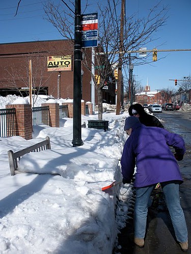
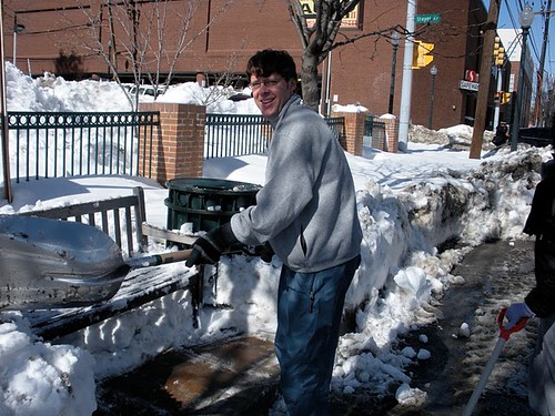
Hans Riemer, who will be announcing his candidacy for Montgomery County Council later this month, helped to organize a bus stop dig out in Silver Spring on Saturday.Tina Slater and Kathy Jentz, clearing out the stop on Fenton near Thayer, downtown Silver Spring.
Bus stop before. Tina Slater and Kathy Jentz, clearing out the stop on Fenton near Thayer, downtown Silver Spring. (Tina is with Action Committee for Transit, and Kathy is the publisher of Washington Gardener Magazine.)

Hans Riemer clearing out a bus stop on Fenton near Thayer, downtown Silver Spring.  Subsequent bus riders stood in the clearing, with bags placed on the bench.
Bus stop after. Hans Riemer clearing out a bus stop on Fenton near Thayer, downtown Silver Spring. Subsequent bus riders stood in the clearing, with bags placed on the bench.

Labels: , , , ,

Sunday, February 14, 2010

The right idea but the prescription is only half right

The solution to problems with democracy is more and better (deliberative, empowered) democracy, not less democracy.

The Post has taken only a year to come to my position that the real problem with WMATA, the Washington Metropolitan Area Transit Authority, is how it is led and the overall vision. See today's editorial, "What really derails Metro," for proof.

From the article (which starts out by talking about the safety-induced derailment of a train on Friday--note that the derailment was proof of a system that is working better than we think, not evidence of a failure of the "system" but definitely evidence of a failure of the operator):

The alarming incident is but the latest evidence of the deterioration of a system that is vital to Washington and its citizens. Events have so eroded confidence in Metro's safety and reliability that it's time the region's political, business and civic leaders address the crisis. ...

Those who have long observed the WMATA board say it is hard for members -- particularly elected officials -- to take off the parochial hats of their jurisdictions in favor of regional interests. ...

Six years ago, leaders from the Metropolitan Washington Council of Governments, the Federal City Council and the Greater Washington Board of Trade, alarmed about Metro's finances, put together a task force whose work led to a dedicated source of money for Metro. The crisis facing Metro today is every bit as serious. It is time to review, and ultimately to change, how Metro is governed.

The problem is that the Post looks to the traditional business powers such as the Greater Washington Board of Trade and their lockstep in thinking elected and appointed officials to solve the problem, even though in some respects it is by relying on the traditional business elites and their worldview that has gotten us to the point that we are at today--remember that it was not the business elite that pushed the subway as much as it was "the people."

I wrote this entry, "St. Louis regional transit planning process as a model for what needs to be done in the DC Metropolitan region" in November.

My prescription for dealing with loss of trust and the need for a new way forward for regional transportation planning and metropolitan transit services is to combine the process currently underway in St. Louis ("Moving Transit Forward") with the previous effort in the Chicago region ("Moving Beyond Congestion") -- a public process focused on laying out a broad concept, vision, and plan for the metropolitan area, renewing commitment to and in transit in the region, and recognizing its vital importance in maintaining the region's economic competitiveness and relevance within the multi-state region, the Mid-Atlantic region of the East Coast, and the global economy.
If people like James Dinegar from the Greater Washington Board of Trade lead the effor called for by the Post, there is no guarantee that the "new and improved" transit system will be any better managed and led than the current system.

Same old same old got us to where we are today.

From the November blog entry:

The DC region needs to embark on a wide ranging metropolitan transit (re)planning public process to restore trust in and a common understanding of the WMATA transit system

After the accident in June, which killed 9 people and injured many others, and the continuing problems with safety, financial problems, lack of a regularized funding system, lack of appropriate regulatory oversight, not to mention problems with how the organization is led from the top (both the Board of Directors and top management), it seems reasonable to have a similar kind of regional transit planning exercise here.

Not only would this restore trust in the WMATA system in the DC region, by building a sense that WMATA is accountable to riders, it would also rebuild a regional understanding of what the system is capable of and how it should expand.

It has been 40+ years since the WMATA Metrorail system was first conceived and 33 years since parts of the system began opening. It's time for an assessment/reassessment.

This ought to be preferred over the grab bag of extension proposals in Virginia and Maryland (with little consideration of the impact on the current system) that the system faces currently.

WMATA only sees the world in terms of subway and bus. So the planning process needs to be broader and deeper, focused on transit generally, not just on WMATA operations as they are set up now.

At the same time, such a process should consider truly regional transit planning (which means including railroad service as an option), and the scope of the study should be broad, rather than overly-circumscribed and limited.

WMATA, in conjunction with the Transportation Planning Board of the MWCOG and the local jurisdictions, as well as MARC and VRE and other appropriate state authorities in Maryland and Virginia as well as DC, should launch a planning process similar to that of St. Louis, to come up with a metropolitan transportation plan that allows for transit services to be delivered where they need to be, but one that uses the most appropriate means (heavy rail, light rail, street car, passenger railroad, different types of bus service) to do so.

It should look at funding issues as well as heavy rail expansion where appropriate. That means not just extending transit service outward, but intensifying transit service at the core as well.

Such a planning process should also consider questions of leadership, management, and oversight. As well as funding.

It's the only way to build a truly regional understanding and commitment to transit for the Washington metropolitan region. Without such a planning process, I think we're destined for a lot more of the same incremental and discoordinated transportation planning that we have today.
At the same time, the District of Columbia needs to understand the centrality of transit to the city's economic and competitive advantages, and plan accordingly.
-------------
The entry then goes on to list 6 key points for a metropolitan transportation vision and plan:

1. Provide more capacity for Metrorail at the core.
2. Extend Metrorail?
3. Change regional land use development policies now, especially those of the federal government.
4. Isn't it time that counties develop complementary surface rail transit programs of their own?
5. Expand and extend passenger railroad services.
6. Continued improvements in bus transportation and customer service.

And since then I have been thinking more about the difference between transportation planning for the metropolitan region, setting metrics for service and quality and the breadth and depth of the network overall, versus who operates what transit service.
In many respects, people treat WMATA as the ultimate actor in this, but really they are the transit operator, and the metropolitan region needs to define the "terms of service," and come up with a way to pay for it, build it, extend it, maintain it, and operate it, regardless of who provides specific services within the metropolitan transit network.

Labels: , , , , , , ,

Friday, January 15, 2010

In the wake of John Catoe's resignation, "St. Louis regional transit planning process as a model for what needs to be done in the DC Metro region"

I wrote this entry, "St. Louis regional transit planning process as a model for what needs to be done in the DC Metropolitan region" in November.

It's even more true today with the resignation/retirement of the WMATA General Manager, John Catoe.

2009 was both the best year that WMATA ever had--providing service, rail and bus, achieving more than 1 million passengers on at least one day during the Inauguration was a high point--and the very worst as the crash killing 9 people (and injuring scores more) in June was the lowest point ever for the system.

The fallout after the crash made very clear that WMATA in terms of how it's overseen (the Board) and managed has serious problems.

Management, planning, funding, leadership, safety systems, not to mention external communications and "customer service" have real problems.

This is from the November entry:

The DC region needs to embark on a wide ranging metropolitan transit (re)planning public process to restore trust in and a common understanding of the WMATA transit system

After the accident in June, which killed 9 people and injured many others, and the continuing problems with safety, financial problems, lack of a regularized funding system, lack of appropriate regulatory oversight, not to mention problems with how the organization is led from the top (both the Board of Directors and top management), it seems reasonable to have a similar kind of regional transit planning exercise here.

Not only would this restore trust in the WMATA system in the DC region, by building a sense that WMATA is accountable to riders, it would also rebuild a regional understanding of what the system is capable of and how it should expand.

It has been 40+ years since the WMATA Metrorail system was first conceived and 33 years since parts of the system began opening. It's time for an assessment/reassessment.

This ought to be preferred over the grab bag of extension proposals in Virginia and Maryland (with little consideration of the impact on the current system) that the system faces currently.

WMATA only sees the world in terms of subway and bus. So the planning process needs to be broader and deeper, focused on transit generally, not just on WMATA operations as they are set up now.

At the same time, such a process should consider truly regional transit planning (which means including railroad service as an option), and the scope of the study should be broad, rather than overly-circumscribed and limited.

WMATA, in conjunction with the Transportation Planning Board of the MWCOG and the local jurisdictions, as well as MARC and VRE and other appropriate state authorities in Maryland and Virginia as well as DC, should launch a planning process similar to that of St. Louis, to come up with a metropolitan transportation plan that allows for transit services to be delivered where they need to be, but one that uses the most appropriate means (heavy rail, light rail, street car, passenger railroad, different types of bus service) to do so.

It should look at funding issues as well as heavy rail expansion where appropriate. That means not just extending transit service outward, but intensifying transit service at the core as well.

Such a planning process should also consider questions of leadership, management, and oversight. As well as funding.

It's the only way to build a truly regional understanding and commitment to transit for the Washington metropolitan region. Without such a planning process, I think we're destined for a lot more of the same incremental and discoordinated transportation planning that we have today.
At the same time, the District of Columbia needs to understand the centrality of transit to the city's economic and competitive advantages, and plan accordingly.

Labels: , , , ,

Monday, January 11, 2010

AP study says road building "stimulus" projects don't employ the unemployed

From "AP: Road projects don't help unemployment" in the Norfolk Virginian-Pilot:

Ten months into President Barack Obama's first economic stimulus plan, a surge in spending on roads and bridges has had no effect on local unemployment and only barely helped the beleaguered construction industry, an Associated Press analysis has found.

Spend a lot or spend nothing at all, it didn't matter, the AP analysis showed: Local unemployment rates rose and fell regardless of how much stimulus money Washington poured out for transportation, raising questions about Obama's argument that more road money would address an "urgent need to accelerate job growth."

Obama wants a second stimulus bill from Congress that relies in part on more road and bridge spending, projects the president said are "at the heart of our effort to accelerate job growth."

The issue really is that construction of a road or any transportation improvement takes a long time, generally, to spur additional development. Sure construction of the road has some employment associated with the construction project, but the substantive return on investment comes later.

So if the road is a "make work" project not likely to substantively contribute to local and regional economic growth, it doesn't make much difference long term.

Similarly, with transit, it isn't just building a transit line that generates return on investment, it's whether or not the line is well routed, both linking activity destinations, particularly job centers with residential areas, and well placed to generate further economic activity.

As that Sam Staley slide used in an earlier blog entry states:

"Transit, highways are mechanisms for providing transportation benefits, not ends in themselves" and "Success depends on economic conditions."

Labels: , , , ,

Monday, November 23, 2009

Transit-mobility stuff

1. Placemaking Institute calls our attention to this September article from the Toronto Star about a condo building constructed with no automobile parking for individual units, but including 315 spaces for bicycles and 9 carsharing spots. See "'Car-free' condo: 42 storeys, no parking: University Ave. project with 315 bicycle spots touted as green model."

I suggested something similar for construction on the land that WMATA wants to sell at the Takoma Station--constructing a multiunit apartment or condo building with no parking for individually owned automobiles, only for shared cars like Zipcar, plus structured parking to support the subway station (ugh) and the commercial distict in both DC and Takoma Park, Maryland. Instead the proposal is to build rowhouses with one to two spaces each for automobiles. (See the 2006 testimony in this blog entry, "Comments on Proposed EYA Development at Takoma Metro.")

Maybe we'll start to see developments marketing their access to bicycle trails and routes? Also see the AP story,Realtors peddle homes to bike-happy clients."

2. The Toronto Star map project has updated its maps on commuting behavior. See "Map of the Week: How we commute, redux," with maps of driving, transit, walking, and bicycling trip data, based on the Canadian Census. Of course, walking and transit use is highest in the core of the city, and driving is more typical the further people live from the core of the Toronto region.

3. If such maps were produced for Seattle, they would likely demonstrate why the idea to pull Seattle transit services out of the King County Metro system might make sense, without changes on the part of King County Metro. According to this entry from the Seattle Post-Intelligencer, "Do we need to pull Seattle Transit out of Metro?":

If the King County Council, dominated by eastside and southside conservative members, insists that Seattle take the lion's share of service cuts, even though in-City buses are already stuffed to the gills, the City of Seattle needs to look seriously at pulling its assets out of Metro and re-establishing Seattle Transit to run in-City (non-suburban) transit service.

As the Toronto maps show, the highest incidence of walking, bicycling, and taking transit to work is in the core of the city. In Seattle's case, there is no question that the bulk of riders on the bus system are Seattle residents. So it doesn't make sense to cut bus service in the places where it is most used, in favor of areas with comparatively less use. The King County Council should make the right decision, based on use, not a political decision that misuses limited public resources.

4. Hip city transportation officials and politicians in Seattle led a "Pedestrian safety dance" (from the P-I) to the song "Men Without Hats" to promote pedestrian safety. See the entry for video from the event.

5. Montgomery County Maryland has three very nice bicycling-sustainable transportation maps for White Oak, Silver Spring, and the Medical Center (National Institutes of Health and the Bethesda National Naval Hospital). These maps are models for promoting bicycling and optimal mobility in key destinations.

6. Although the NoMA Business Improvement District in DC is also doing a nice job of promoting bicycling.

7. I did my first presentation on biking and walking and the County's bicycle and pedestrian planning process for my job. I am positioning the study process along the lines of civic identity and quality of life, rather than bicycling and walking per se. Some points from my presentation outline:

--------
How to Do it/Citizen involvement/A more robust planning process

a. Defining your civic identity and sense of place. Question: What kind of community do you want to live in? Making choices. Fred Kent from PPS: “if you design communities for roads and traffic, you get lots of cars and traffic. If you design communities for people and places, you get people and places.”

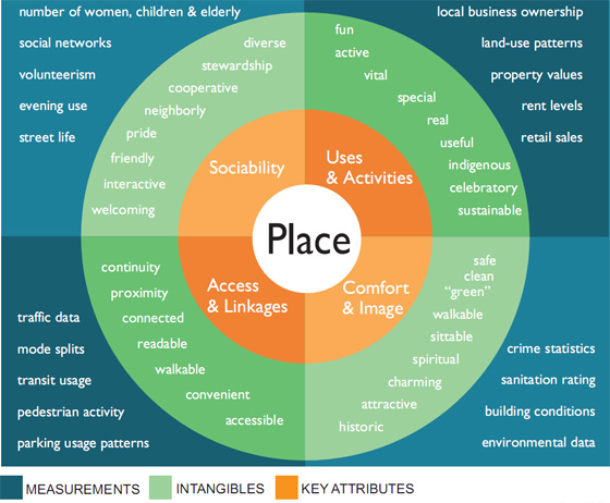
b. Focus on Placemaking (Access; Comfort & Image; Uses & Activities; Sociability). [Based on Project for Public Spaces ideas, e.g., "Qualities of Great Streets."}
http://www.placemakingchicago.com/cmsimages/place-diagram.jpg

For this PPS diagram and more information, see Four key qualities of a successful place from the Metropolitan Planning Council of Chicago initiative with PPS, Placemaking Chicago.

c. Triangulation: considering needs from at least three vantage points. Multiple perspectives ensures a more accurate assessment of community needs and helps to make choices and set community priorities. (This is a concept applied by David Barth of Glatting Jackson in best practices park planning. See "Parks System Master Plans: Tools for Sustainable Communities.")

d. Active Citizenship. Civic engagement, building support organizations, and the county commitment to walking and bicycling (and transit and transportation demand management and sustainable transportation) by involving concerned and interested citizens more directly.

e. It is important for citizens to not only improve their own household's mobility behaviors while advocating for neighborhood improvements while at the same time simultaneously supporting and advocating for improvements in the walking and bicycling environment throughout the County, and expansion of a connected regional network of recreational trails/greenways.

f. Necessary for residents, elected and appointed officials, government agencies to be on the same page in terms of focusing on placemaking and the importance of bicycling and walking in terms of extending the quality of life and livability in the community, making the County more attractive to investors, businesses, students, and visitors.
-------

This is designed to get away from the idea of bicyclists and walkers as "the other" in a County where probably 95% of households have cars, and fewer than 7% of trips to work are made by walking, bicycling, or transit. (In DC, it is over 50%, in Montgomery County, it is.)

(See the past blog entry, "Deja vu all over again: the "other" as trail user" which describes a general problem of perception that I have to deal with in the planning process I am managing in order to achieve the goals that I have set out for myself.)

And it is an opportunity for me to shape the planning and public participation process in ways that I wish similar processes had been conducted in planning studies that I have participated in as a citizen or as a stakeholder in DC, but where I wasn't able to shape substantively the scope of work or organization of the study or process.

8. Interesting article in the Philadelphia Inquirer, "Freewheelers," about the "Old Spokes" bicycling club made up of residents of the Normandy Farms Estate retirement community in Blue Bell, Pennsylvania. I intend to use this when dealing with the "cyclists as criminals" arguments that people raise.

9. And I like what Rails to Trails Conservancy did (they have a contract from DC DOT) to do promotion in association with the Metropolitan Branch Trail in DC. See "Children journey into a new world: With 40 free bikes, Rail-to-Trail Conservancy encourages youths to explore eight-mile path" from the Post about how RTC has distributed bicycles to children in neighborhoods abutting the trail.

Labels: , , , , , , ,

Monday, November 09, 2009

Surveying political candidates on their transportation behaviors

According to "Transit riders movement" in the Boston Globe, a coalition of groups asked candidates for Boston City Council a number of pointed questions on mobility, and created a website with the results for each office.

BOSTON CITY COUNCIL CANDIDATES TRANSPORTATION SURVEY

1. What is the most unsafe aspect of the current transportation system in your district/in the city, and what do you propose be done to improve the situation?

2. We know that lack of physical activity leads to overweight, which leads to rising health care costs. How would you make it easier for people to incorporate physical activity into their everyday activities by making it significantly easier for Boston residents to move around their communities by foot or by bicycle? What would you do to encourage the Safe Routes To School program or other ways to increase the number of children who walk or bike to school? What would you do to make it safer for seniors to walk or bike on our sidewalks and across our streets?

3. What would you do to help get increased public transportation services in your district/city? In particular, how would you help bring rapid transit to the large sections of Roxbury and Dorchester that currently lack it?

4. How would you apply "complete streets" design concepts, already being discussed by city agencies, that meet the needs of all travel modes including bicycle, pedestrian, transit, and automobiles, to all city streets, rather than just to those being repaired? How would you prioritize which streets are to be dealt with first?

5. Street space is the largest physical asset owned by the city. Devoting almost all of it to car traffic has a major impact on neighborhood quality of life. On what streets would you propose that pedestrian and cyclist use be prioritized, for example through the creation of temporary "cyclovias" that only allow non-motorized travel, or more permanent "shared spaces" and "bike boulevards" that allow cars but at reduced speeds?

6. Currently, it is technically illegal to ride a bike in city parks; and many neighborhood parks are underutilized. What would you do to increase access to parks by foot or bike or public transportation, and to facilitate cycling in the parks?

7. Better parking management is even more of a need in many commercial centers than more parking spaces. Reduced parking requirements (in zoning ordinances), Parking Benefit Districts, and other market based policies that price city-owned curb parking to reflect market rates are methods that can help to alleviate parking congestion and shortages. How would you better manage commercial parking areas in your district/in the city?

8. How would you leverage opportunities for Federal stimulus funding to create a more "active transportation" infrastructure in our city? What federal programs do you consider most able to be used for this purpose?

9. Many bicyclists feel under assault on Boston roads and many drivers view bicyclist as serious nuisances. How would you address the attitudes of drivers and bicyclists to promote a more civil atmosphere of road sharing and cooperation on city streets? How would you incorporate driver and bicycle training programs into the educational system of your district/city?

10. How do you personally get around the city? Please give percentages for walking, bicycling, public transportation, and automobile.

Labels: , , , , , ,

Sunday, November 08, 2009

Charlotte Mayor Patrick McCrory on transit

From "Charlotte Mayor Patrick McCrory advocates Bay area rail" in the Tampa Bay Business Journal:

“Wherever you put transit, it will create jobs,” he said. “The more choices you have, the more the consumer will want to live, work and play here.”

I don't think this is exactly correct. If you don't put transit in the right place, and you don't have a transit system, it may or may not work well for your community and your region. The Baltimore region is a case in point. Neither the subway line (estimated ridership: 58,000 daily) nor the current light rail system (estimated ridership: 33,500 daily) have had the kind of impact that transit has had in other regions across the county.
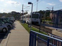
Light rail station in Hunt Valley
Light rail station in Hunt Valley, Baltimore County, Maryland.

Part of that has to do with the relative decline of Baltimore in favor of other locations in the region. But it mostly has to do with the failure to adequately place transit within the region, as well as the failure to build an extensive transit network that can move people efficiently between activity centers and neighborhoods.

The light rail line shows that putting light rail where you have right of way (an old railroad line) often isn't the right choice, as it is more important to link in-demand destinations and place neighborhood transit stations in accessible places so that people will choose to ride transit.

(Note that Rollin Stanley mentioned the Charlotte station area plans as particularly good examples of how to link land use planning to transit and transformation. I haven't checked any of them out.)
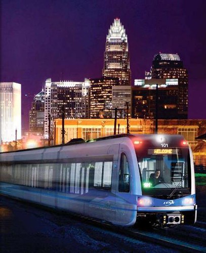
Photo of Charlotte's light rail train
Charlotte's light rail train (photographer unknown). Charlotte has another advantage over Baltimore with the light rail in that they are using the latest generation vehicles which are much more attractive and sleek compared to the light rail vehicles deployed when Baltimore opened their system.

Labels: , , ,

Friday, October 16, 2009

Reprint (with editing): The Meta-Regional Transit Network

In the entry, "Second iteration, idealized national network for high speed rail passenger service," I discussed how transportation planning within the U.S. should occur on five distinct but interconnected levels:

- international (connections between countries);
- national (such as the Interstate Highway system or the proposed High Speed Rail Initiative);
- regional or multi-state (freeways sure but also railroads, such as passenger railroad service in NY, CT, NJ, and PA);
- metropolitan such as the subway and bus system for the Washington metropolitan region, which is anchored by the WMATA system and the VRE and MARC railroads; and is supplemented by
- submetropolitan transit networks at the suburban and city levels.

This framework is an extension of my other writings about the transit network within metropolitan areas. (Which in turn is an extension of ideas expressed within the Transit Element of the Arlington County Master Transportation Plan.) But when I first wrote about it, because I was more focused on the spatial scale within a metropolitan area, I called it the "regional" network. It is, but in the context of interconnected transit networks, it should have been termed "metropolitan" in scale, rather than regional.

So this is reprinted (with a couple other fixes) to correct the mistake in word choice, to make the language consistent between the scales of local, metropolitan, regional, national, and international transit networks.

A framework for an all encompassing DC-MD-VA transit network

Meta (or Multi-state) Regional Transit Network: MARC and VRE service ideally combined into one multi-state compact and system, with service as far south as Norfolk and as far north as Wilmington, DE and Harrisburg, PA, and west to Charlottesville, VA (or beyond), with intermodal stations connecting to heavy and light rail transit systems; supplemented by Amtrak. This could include railroad and water-based transportation.
Railroad passenger statistics, Metro-North
(The model is the LIRR and Metro-North railroad system in the New York City region, which is managed by the Metropolitan Transportation Authority of New York, and runs 24/7/365.)

Washington Metropolitan Transit Network: Regional WMATA subway system; ferry system if added; cross-jurisdictional bus rapid transit; commuter services oriented to moving people between the jurisdiction and major job centers within the region, across jurisdictional boundaries (i.e., OmniRide from Prince William County, which provides commuter-oriented service to Metro stations and job centers, with an end point in DC [and back] or the MTA Commuter buses in Maryland).

Suburban Primary Transit Network: transit systems operated by Counties and Cities in the Washington region providing bus, streetcar, and lightrail service within the suburbs, and connections to stations within the metropolitan transit network. Transit service in this category is classified by speed and destination.
Montgomery County Ride-On Bus
Montgomery County's RideOn bus system is one of the more successful suburban transit systems in the United States. I don't think it provides cross-jurisdictional service, other than service along Western Avenue (which technically is 100% in DC), maybe Eastern Avenue, and to the Takoma Metro station and in the Langley Park area of Prince George's County. Photo from
BeyondDC
.
Rendering, streetcar service on Columbia Pike, Arlington and Fairfax Counties, Virginia
Rendering, streetcar service on Columbia Pike, Arlington and Fairfax Counties, Virginia.

Suburban Secondary Transit Network
: service within cities (i.e., Falls Church, Alexandria) and counties (PG, Montgomery, Arlington, Fairfax) that is intra-jurisdictional.

DC Primary Transit Network: Core of the WMATA system in DC (29 stations); streetcar system; Downtown Circulator bus service; Georgetown Connector shuttle service; cross-border WMATA bus service; bus rapid/"rapider" transit.

DC Secondary Transit Network: the other 11 subway stations in the city; other WMATA bus service within the city; water taxi service if added, depending on the routes.

DC Tertiary Transit Network: intra-neighborhood bus services. Maybe private shuttle services (i.e., Washington Hospital Center to/from Brookland Metro, university shuttle services, etc.). (The model for this type of service would be the Tempe, Arizona Orbit bus service, see "Earth Day and Neighborhood Transit.")
Subway stations at the core of the city of Washington
The subway stations at the core of the city of Washington comprise the foundation of the DC Primary Transit Network.

Note that if the two new subway lines were added in the city, as proposed on the map below, then this would change the definition of the core of the DC Primary Transit Network considerably.
Conceptual map for transit expansion in the DC region
Conceptual map for transit expansion in the DC. Map courtesy of David Alpert, Greater Greater Washington.

Other cities in the multistate region can be incorporated into this broad framework quite simply. The meta regional network is at the top of the hierarchy, then there are metropolitan networks, divided into broad tranches within the respective metropolitan region, separated into the suburban transit network and the center city network. The center city is likely to have the densest network of service, with as many as three subnetworks (primary, secondary, and tertiary, as outlined for DC above).

Baltimore Metropolitan Transit Network: light rail; cross-jurisdictional bus rapid transit; commuter services oriented to moving people between the jurisdiction and major job centers within the region, across jurisdictional boundaries.

Baltimore Suburban Primary and Secondary Transit Networks: (however they may be differentiated), but hubs for organizing service within the system are set by the transitshed of the Light Rail and MARC lines, and the mobilityshed of individual stations.

Baltimore City Primary and Secondary Transit Networks: Primary: subway, light rail, cross city buses. Secondary: other bus service, water taxi, aerial tram. They could set up a tertiary system as suggested above for DC. Etc.
100_9090.JPG
The new Baltimore Circulator bus will provide free service.

Similarly, Richmond's GRTC provides some service oriented to commuters located some distance from the city, such as between Petersburg and Richmond, and between Richmond and Fredericksburg, the latter to connect to the VRE.

Were I to create an organizational chart, the top level would be the meta regional transit network; the four major metropolitan regions in the tri-state region: Baltimore, Hampton Roads, Richmond; and Washington would have boxes on the next level; and the third level of the chart would show other areas deemed metropolitan regions, but are at a significantly smaller scale, such as Hagerstown and Charlottesville.

Regions that might normally be listed on the third level of the chart such as Petersburg, Fredericksburg, Frederick, even Harpers Ferry-Charles Town, could also be listed in a fashion subsidiary to major regions, i.e., Petersburg to Richmond, Fredericksburg to DC, Frederick to DC and/or Baltimore (although BeyondDC describes Frederick as now a suburb of Gaithersburg), Annapolis to DC and Baltimore, etc.

Under each Metropolitan region there would be organizational levels for the suburban network; under which the primary and secondary networks would be listed, with separate boxes under the secondary network for each intra-jurisdicational service; and the center city transit network, under which the center city primary, secondary, and tertiary networks would be listed.

Labels: , , , ,

Monday, March 30, 2009

In Phoenix region, Average cost of transport consumes 3 months' pay

See "Average cost of transport consumes 3 months' pay," from the Arizona Republic. From the article:

Maybe you've heard of Tax Freedom Day, theoretically the date when Americans have worked enough to pay off their tax burden for the year.

Researchers have now come up with Transportation Freedom Day, the date when an average household has paid off its annual costs of getting around in a particular city.

For metro Phoenix, that day fell on March 23, but it's different for each city in the region and across the country. Tempe residents cleared the typical cost of car payments, insurance, gas, repairs and transit use on March 18. Residents in New River will keep paying until April 9.

Phoenix is in the middle of the pack for U.S. metro areas. Cheapest are San Francisco, with a March 1 freedom day, and New York (March 7). Tucson (March 30) is near the bottom.

See the Transportation Freedom Day website for images.

According to this report, Transportation Freedom Days from U.S. Metro Areas, the date for the DC region is March 10th. ... but not if you bicycle and/or use transit.

http://www.uspirg.org/uploads/bW/QP/bWQPawlJ7OYr3Qk2aeALOA/Trans-Free-Day-Logo-Final.jpg

Labels: , ,

Wednesday, February 18, 2009

More indicators

1. If pedestrians keep getting hit by cars at particular intersections as discussed in "D.C. cop pleads with pedestrians: Pay attention" from the Examiner, about the intersection of Connecticut and Nebraska Avenues NW, then there is a clear design problem that needs to be rectified.

Generally, I argue that if a solution for one government agency creates a problem for another government agency, then the problem isn't solved.

2. The #$%^&*() DC Circulator bus isn't a solution for low use bus routes. The Examiner also reports how "Local D.C., Fairfax bus services may take on more Metro routes" in part to save money for WMATA.

The concept of the Circulator bus is frequent service means that riders don't have to worry about waiting for a bus, and that ridership will increase significantly.

Currently, 1,560 people ride the N22 in the Union Station-Capitol Hill-Navy Yard area. THAT IS AN INDICATOR THAT THERE ISN'T DEMAND FOR THE SERVICE, EITHER BECAUSE IT DUPLICATES EXTANT SERVICES, OR BECAUSE THERE ISN'T NEED FOR THE SERVICE.

By way of comparison, more than 20,000 people ride the 30s buses on Pennsylvania Avenue that also serve part of this route. The 96 bus also provides some service between Capitol Hill and Union Station. Other 90s buses provide service along 8th Street SE between the Navy Yard and the Eastern Market Metro station.

Don't replace this bus with a DC funded "Circulator." Cancel the service.

Clearly, there isn't a high demand for bus travel between Union Station and Eastern Market and Eastern Market and the Navy Yard or people would be riding this bus.

Times of financial exigency are times where clear thinking is particularly important. It's true for both of these examples.

Labels: , , , ,

Wednesday, February 11, 2009

"Green" transportation

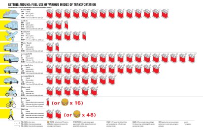
Another lesson in absolute vs. relative improvements in environmentally-positive oriented behavior comes from Good Magazine, courtesy of reader Steven and this graphic:
Energy used to transport one passenger of various forms of transportation, resized
For the full sized version, click here.

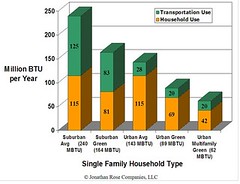
And, this graphic is always good for review...
Energy consumption: Suburban Sprawl vs. Green Urban

Labels: , , ,

Friday, January 16, 2009

What's in the stimulus package

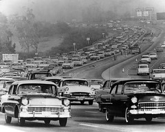
freeway_1961
City Skip posted some photos of Los Angeles from the Los Angeles Public Library Collection, including this one of the Hollywood Freeway from 1961, in this entry, "Found Photos: Old Los Angeles."

Chris M. looked at the bill, and extracted this:

Modernize Roads, Bridges, Transit and Waterways: To build a 21st century economy, we must engage contractors across the nation to create jobs rebuilding our crumbling roads, and bridges, modernize public buildings, and put people to work cleaning our air, water and land.

•$30 billion for highway construction;
•$31 billion to modernize federal and other public infrastructure with investments that lead to long term energy cost savings;
•$19 billion for clean water, flood control, and environmental restoration investments;
•$10 billion for transit and rail to reduce traffic congestion and gas consumption.

MODERNIZE ROADS, BRIDGES, TRANSIT AND WATERWAYS
To build a 21st century economy, we must engage contractors across the nation to create jobs - rebuilding our crumbling roads and bridges, modernizing public buildings, and putting people to work cleaning our air, water, and land.

Highway Infrastructure: $30 billion for highway and bridge construction projects. It is estimated that states have over 5,100 projects totaling over $64 billion that could be awarded within 180 days. These projects create jobs in the short term while saving commuters time and money in the long term. In 2006, the Department of Transportation estimated $8.5 billion was needed to maintain current systems and $61.4 billion was needed to improve highways and bridges.

Transit: Public transportation saves Americans time and money, saving as much as 4.2 billion gallons of gasoline and reducing carbon emissions by 37 million metric tons each year.

•New Construction: $1 billion for Capital Investment Grants for new commuter rail or other light rail systems to increase public use of mass transit and to speed projects already in construction. The Federal Transit Administration has $2.4 billion in pre-approved projects.

•Upgrades and Repair: $2 billion to modernize existing transit systems, including renovations to stations, security systems, computers, equipment, structures, signals, and communications. Funds will be distributed through the existing formula. The repair backlog is nearly $50 billion.

•Transit Capital Assistance: $6 billion to purchase buses and equipment needed to increase public transportation and improve intermodal and transit facilities. The Department of Transportation estimates a $3.2 billion maintenance backlog and $9.2 billion in needed improvements. The American Public Transportation Association identified 787 ready-to-go transit projects totaling $15.5 billion. Funds will be distributed through the existing formulas.

Amtrak and Intercity Passenger Rail Construction Grants: $1.1 billion to improve the speed and capacity of intercity passenger rail service. The Department of Transportation’s Inspector General estimates the North East Corridor alone has a backlog of over $10 billion.


Worldchanging is really really really really really disappointed with Ray LaHood for Secretary of Transportation. See "Ray LaHood and Changing our Thinking About Transportation."

Labels: , , , ,

Thursday, January 08, 2009

Manufacturing mobility chaos

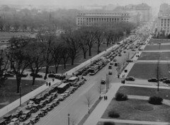
Aerial view of a traffic jam, 14th Street and the Mall, Washington, D.C.,
Aerial view of a traffic jam, 14th Street and the Mall, Washington, D.C., 1937. National Archives photo.

1. Dorothy Brizill, in themail, comments in "Shutting Down DC" about how the U.S. Secret Service's plan for street and road closures during the inauguration will close to vehicular traffic not just streets in the center of the city, but the bridges crossing from Virginia to DC, as well as DC's bridges on South Capitol Street (from Maryland) and 11th Street between Anacostia and Capitol Hill.

This is written up in the Post, in:

-- Inauguration to Close Off Most Bridges to District
-- MAP: Inauguration Transportation Plan Released
-- Dr. Gridlock, Get There: Plan Walls Off Washington -- this lists all the closures in text form.

I think we know the likely impact from this. (Especially if you remember the chaos on the streets on 9/11, or even the typical outmigration when the Federal Government lets people go home early because of snow.) All the more reason, as some are doing, to get out of town. See "An Amazing Event Not to Be Here For: As Crowds Plan to Pour In for Inauguration, Many in Area Seek a Way Out" from the Post.

Metro farecard machines

2. More chaos will result from people unfamiliar with the subway system trying to buy Metrocards.

Why is it that people unfamiliar with the system, paying cash, are drawn like flies to light or sugar to the "blue" farecard machines, the machines that take longer to use and are set up for credit card transactions, adding money to Smart Cards, and downloading transit benefits.
Tourists trying to navigate the Metro system
Susan Biddle/Washington Post. Summary: Tourists trying to navigate the Metro system - everything from fare card system to too infrequent signs. This family from Chicago was totally confused at Gallery Place even with the new lighted signs. They were trying to go to the Spy Museum but the signs said 7th and H one way and 9th and G the other - no sign for the Spy Museum which is at 9th and F. (August 2005)

At best a gray ticket machine is probably capable of 4 transactions per minute, so 6 machines could in theory process up to 2400 transactions per hour. Except that such a throughput level is likely unsustainable in the face of wrinkled money and lack of familiarity.

According to the Washington Post, in "60,000 Volunteer for Inauguration; Most Won't Make Cut," thousands of people want to volunteer during the Inauguration. I suggest "regiments" of volunteers be deployed to subway stations, to assist people in buying farecards.

And WMATA should consider having certain employees loaded up with $10 farecards in advance, and selling them--only cash transactions--from a position outside the stations, before people get to the farecard machines.
Protestors at Greenbelt station
Greenbelt Metro station full of protestors looking to get to the National Mall to demonstrate, but having to buy a Metrocard first (2006).

Labels: , , , ,

Sunday, January 04, 2009

Saving the U.S. means rethinking mobility AND LAND USE

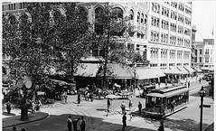
Streetcar on F Street, postcard
Streetcar on F Street, postcard image. Note pedestrians, cars, a horse drawn carriage, and a streetcar.

I was reading the latest issue of the Sustainable Transportation Magazine from the Institute for Transportation and Development Policy, and one of the articles is on Bogota. It mentions in the course of the article that the transportation director there is termed the "Secretary of Mobility." (That will end up in my forthcoming DC Transportation Vision Plan/Wish List for 2009.) Note that the magazine is published annually, and the current issue is not yet available online.

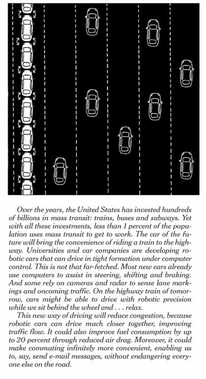
Ironically, because I just reprinted an entry from 2006 which discusses the problems of the U.S. automobile industry long before they came to the Federal Government for massive loans, there is a piece in today's New York Times about how technology and some changes in approach (business model) can save the automobile industry, in "Four Ways for Detroit to Save Itself," by Sebastian Thrun and Anthony Levandowski.

Technology isn't the problem (of transit) so much as how the U.S. organizes land use and mobility.

Of course, this piece is going to "anger me" from the outset because it makes the point that despite all the money spent on mass transit, fewer than 1% of work trips use transit.
Saving the automobile industry through technology, frame 2, resized
Frame two of the Thrun and Levandowski article. New York Times image.

I am surprised to see this in the New York Times, because in NYC, more than 50% of people ride transit to work and close to 50% of New York City households do not own cars, and it is a perfect example of when land use and transportation policy and transit systems are coordinated at a deep, wide, and intricate level, then automobility is trumped.

Of course, the subway system in the Washington, DC region shows this also. When you have concentrated land use, mixed use, and density of buildings and population, you yield high transit use and reduced automobile use and ownership. The varying impact of the subway system in the DC region on these factors is a perfect example of" how to." Take areas like the core of DC, the Wilson Boulevard corridor in Arlington, Silver Spring in Montgomery County as pro-examples, and areas outside of DC's core within DC, Fairfax County, Prince George's County, etc., as examples of where transit doesn't accomplish as much because there isn't supporting land use and urban design policies which embrace and extend the value of transit.

And of course, the fact that Detroit as a city is a disaster is another example. My joke about Detroit, being that it is criss-crossed all over with freeways and arterial roads, and is relatively undense these days (Detroit never had rowhouses as a housing-building-neighborhood type, unlike the East Coast cities, and Pittsburgh and Chicago), is that its decline is exactly what the automobile industry wanted to have happen to center cities, to force people to need automobiles to get around. Before the destruction of streetcar systems, center cities were a pretty good "mobility technology," having high connection between job location and housing location, and efficient public transit systems to get people in between.

When you have deconcentrated and homogeneous land uses, of course transit isn't going to divert many trips.
GE Streetcar ad, 1940
GE Streetcar ad, 1940.

So yes, point two in Thrun and Levandowski's article "angers me." And their "solutions" won't really help the automobile industry all that much. Technology isn't the issue. How they build cars, how the business system is organized, how U.S. companies have a much different system in terms of pension and the provision of health insurance compared to their competitors, and legacy costs are more important.

As is the cost of gasoline. Europe has the highest cost gasoline in the world, the cost mostly due to high excise taxes charged to reduce the use of cars and to pay for road infrastructure as well as transit. But Europe still has some of the most successful car manufacturers in the world including BMW, Mercedes, and VW. Both the European divisions of GM and Ford do reasonably well also. (Their fortunes wax and wane given how much involvement they have to deal with from the U.S. parents.) Even Fiat seems to be doing much better. Nissan-Renault is positioned to remain a successful company, with one foot in Europe and the other in Japan.

Raise gasoline taxes significantly in the U.S. and the locally based industry will be forced to rightsize and become competitive on the same basis as the companies in other countries, where the business model and conditions are already at the same point where they are moving towards in the U.S.

But technologizing the car industry won't help the U.S. all that much, because we need to spend less money as a nation on road infrastructure, and as households, especially if we are to see income declines of a significant nature and we are to cope, we need to spend less money on transportation.

The typical U.S. household spends around 20% of total income on transportation (mostly buying and maintaining cars). An urban household in a city like New York City, Washington, Chicago, Philadelphia, or Boston can easily spend less than 3% of their total income on transportation, given the widespread availability of public transit. That leaves a lot more money to be spent on other things. In our case, that "extra" money is spent on an amazing house.
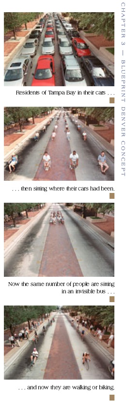
Packing the pavement: different modes take up vastly different amounts of space
Each of these images shows 40 people and how different modes take up vastly different amounts of space to move the same number of people. People in Tampa. Image reprinted in a Denver planning publication.
Labels: , , , , ,

Friday, January 02, 2009

The grass is greener, but...

streetsie award
For those of us not in NYC, sometimes it's hard to believe that there is so much to fix, given that pedestrian-transit centricity is so strong there. But that being said, it's the same for DC. DC is better than a lot of places in terms of livability and walkability, yet it can be so so so much better. And it's the job of advocates to point out the opportunities and the problems (I like to think of the word problem as a synonym for opportunity).

So the work, writing, and other efforts of the folks at Streetsblog and the Open Planning Project in NYC help lead the way towards more complete places, and pro-walking, pro-bicycling, pro-transit, pro-urban mobility policies.
This week they have five entries on what they call the "Streetsie Awards."

-- The 2008 Streetsie Awards, Part 5
-- The 2008 Streetsie Awards, Part 4
-- The 2008 Streetsie Awards, Part 3
-- The 2008 Streetsie Awards, Part 2
-- The 2008 Streetsie Awards, Part 1

-----------------
Relatedly, Washcycle has two good entries, along similar lines, but specifically about bicycling in the Washington region:

-- 2008: A Look Back
-- 2009: Looking Ahead

Washcycle is very good about regional bicycling issues. I am not able to stay on top of many of the issues in the region to be able to write the kind of complete but broad regional perspective pieces that I might want to. DC stuff, and I can't even keep up with that, keeps my mind plenty occupied.

(I do pay attention to stuff in Montgomery and Prince George's Counties in Maryland, in part because DC is physically connected to those places and now I live within one mile of both counties and I try to read the Hyattsville and Takoma editions of the Gazette, Baltimore--I read the Baltimore Sun every day, and to some extent, Arlington County in Virginia. But it's hard to keep up with things beyond those places...)

Labels: , , , , ,

Tuesday, December 02, 2008

The launch of the Streetsblog network

Streetsblog, the NYC-based blog which is a project of The Open Planning Project , has organized a "network" of like-minded urbanism-oriented blogs across the country. See "Introducing the Streetsblog Network."


In the DC area, the following blogs are included:

Arlington's Car-Free Diet Blog Arlington, VA

Promoting car-free transportation options.

Beyond DC Washington, DC
Transportation policy and smart growth in Washington, D.C.

Greater Greater Washington Washington, DC
The Washington, DC, area is great. But it could be greater.

Rebuilding Place in the Urban Space Washington, DC
Focuses on place and placemaking and all that makes it work.

Rethink College Park College Park, MD
Helping imagine a great college town for a great university.

WashCycle Washington, DC
Cycling advocacy in the nation's capital.

I have links to a number of the other blogs, but there are many good ones I've missed... Check out the About Streetsblog Network entry for all the links. For the purpose of this entry, I haven't included the blogs from Baltimore and RoVA that are also listed. (Speaking of expansiveness of the greater region though, yesterday I added newspaper media links for Charleston and Martinsburg, WV and York, PA.)

Labels: , , , , , ,

Tuesday, November 18, 2008

Same old, same old

Did you ever read "News of the Weird" when they would have a rolling mention of "stories for which coverage is being 'discontinued' because they occur with altogether too much frequency?

That's how I feel about the "annual" story that seems to run in the Post every year about area pedestrian-driving safety programs. The 2008 version ran today, "Heads Up for Drivers, Pedestrians: 'Street Smart' Program Includes Education, Enforcement," and I hate to say that I didn't even read the article. It's the same thing year after year, in fact after I saw the headline, I thought it would be interesting to go through the Post and find the same article from each of the previous 5 or 6 years and compare and contrast.

-- 4/2008, "A New Push for Pedestrian Safety"
-- MWCOG Street Smart program

Yes, bicyclists and walkers need to pay more attention.

But the problem I see is that drivers have such a sense of entitlement about the roads that it isn't about courtesy. Even if commentators try to turn it around on walkers and bicyclists (such as the radio commentary by Chris Core, covered by Washcycle here, "Chris Core on "The Growing Phenomenon of Bicycle Road Rage"" and "Chris Core's follow up").

And we need some roads rebuilt as demonstration projects to favor walkers and bicyclists, to show another way.

It's time to change the paradigm.

Road Witch (UK)
Road Witch project. UK.

It's like an example I give sometimes. If you have a five drawer clothes dresser and you move your underwear from the 2nd drawer to the top drawer, and your socks from the top drawer to the 2nd drawer, have you really changed anything?

• Let's rebuild 7th Street SE by Eastern Market with belgian block (Oh no we can't because that means that the roadbed would have to be reconstructed) and around Lincoln Park--take out the speed bumps and tables and put in Belgian block.
Monument Avenue, Richmond
Belgian block paved road, Monument Avenue, Richmond.

• Let's set up bicycling and walking programs at the schools.

• Let's set up bicycling stations in the key commercial districts (parking, showers, etc.) at the least Downtown (could do it at the YWCA), Georgetown and the Golden Triangle (could do it at the YMCA), and Silver Spring.

• Let's put in a cycle track in a highly visible location, where it will be used. Why not do this as a memorial to Alice Swanson and the other bicyclists, who have been killed in bicycle-automobile accidents?
Bicycle lane, Copenhagen
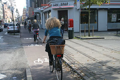
Bicycle track, Copenhagen. Photo from Streetsblog.

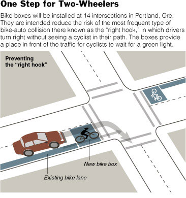
• Some painted bicycle boxes?
Bike box for bicyclists on the road in Portland
New York Times graphic.

• having WMATA (the public transit authority for the region) appoint a bicycling and pedestrian enhancement coordinator to point out areas where WMATA can better facilitate walking and bicycling as part of trip behavior?

The annual campaign by the MWCOG is just moving the socks around, when the automobility paradigm reigns unchanged.

This report from the UK, Living Spaces: Cleaner, Safer, Greener, had a lot of influence on my thinking about these issues when I first read it maybe 4-5 years ago.
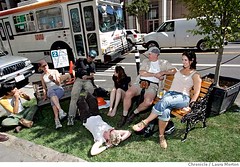
Port-a-park: A temporary park was set up in a parking space on Mission Street by Rebar, an art collective.
2006. The group Rebar declared Sept. 21 "Park(ing) Day" and installed this temporary park in a parking space on Mission St. in downtown San Francisco, CA. The group moved the park to several different parking spaces throughout the day. Port-a-park: A temporary park was set up in a parking space on Mission Street by Rebar, an art collective. The park was moved several times that day. Chronicle photo by Laura Morton

Labels: , , , ,

Sunday, November 16, 2008

Is a bicycle a means to mobility or a fashion statement?

Yes. You can buy a bicycle from the Gap this year.

Labels: , ,