Fabulous Pearlstein article on the future of the (DC) metropolitan region
Steven Pearlstein, the former business columnist for the Post and now a professor at George Mason and scribe of a weekly column for the paper has a well done piece, "For development, all signs point inward" (the headline in the print edition was "Road to growth is out of the exurbs") in the Sunday edition.
From the article:
... the next phase of growth in the Washington region will focus on these underdeveloped areas in the eastern quadrants of the District and some of the region’s older, closer-in suburbs.
It’s not just smart-growth planners and anti-sprawl activists who think so; most developers I’ve spoken with in recent weeks agree. The models for the future, they say, can be found in Pentagon City rather than Dale City, along the Rosslyn-Ballston corridor rather than the far reaches of the Dulles corridor, in the NOMA area near Union Station and the downtowns of Bethesda and Silver Spring. The pressure of development now points inward toward the Capitol, not outward toward Germantown, Gainesville, Waldorf and Laurel.
Consider, for example, Crystal City, with its proximity to Reagan National Airport, spectacular views of the Potomac and the national monuments, its Metro stop and easy access to highways leading in all directions. If ever there was an ideal location for prime office and hotel space and high-end condos with all the amenities, this is it. And yet for years, legions of GS-13s and mid-level defense contractors toiled in its sterile office buildings and criss-crossed its warren of underground malls before driving home on streets devoid of interesting retail stores, restaurants or pedestrian life. It took the heavy hand of the Pentagon and its base closure commission to do what the market should have, forcing a redevelopment aimed at higher-paying, private-sector tenants.
The rationalization of land use in the region is now being driven by fundamental shifts in the economics of housing and commercial development.
Note that this is the thesis of Belmont's Cities in Full: Recognizing and Realizing the Great Potential of Urban America, which I consider to be the most important book in urban planning since Jane Jacobs. Belmont argues in favor of "recentralization" of commerce, housing, and transportation towards the core of a region.
Points in the article include:
- the value of proximity
- decline of traditional suburban shopping malls
- decline in value of suburban office parks
- rise in interest in mixed use developments by consumers and developers
- massive decline in the value (65% drop)
of distantly located subdivision developments
- rise/maintenance of real estate property value in inner core submarkets
- that infrastructure investment will be required
- planning commitment is required
- and it takes a long time (he says the development along the Wilson Boulevard in Arlington County took ten years, the reality is that the period was much longer)
- he recommends the creation of special taxing-redevelopment districts.
And Pearlstein focuses on the potential of Prince George's County, discussing how GSA made a mistake to not locate a major federal office complex in the County.
On this I disagree somewhat, not because PG County is poorly located, but because Pearlstein inadequately recognizes the value and necessity of the right type of urban design (grid network of blocks and streets) as a building block for intensifying development, combined with high quality transit service.
Smart Growth and TOD strategies for the most part, start with place, start with already extant centers.
PG County needs to change how it develops (the focus is still on large tracts of land, wherever they are, usually in distant locations, and not usually proximate to transit) and how it (re)designs how it develops--blocks and streets and mixed use and transit--before it can truly reap the value of its location within one of the nation's strongest real estate markets.
-- Trans-Formation: Recreating Transit-Oriented Neighborhood Centers in DC: Design Handbook (2003), report from the DC Office of Planning)
While it is true that the "Arts District Hyattsville" project on Route 1 in Hyattsville and the area around Prince George's Plaza too, are examples of the kind of recentered development that Pearlstein writes about, failures in urban design execution in these and other projects along Route 1 (apartment buildings focused on serving the college student population at the University of Maryland) show that the county lacks a commitment to creating fine grained walkable urbanism, at least so far--these places are mixed use, but the urban design doesn't fully work.
Fortunately, as I have argued before, PG County has the opportunity for a second chance at changing their urban design paradigm with the coming of the Purple Line light rail (and planning for its extension to Alexandria) and the ability to refashion areas around stations and corridors towards a newer transit-centric reality.
-- "A recommended new planning direction for Prince George's County," March 2011
-- "The future of mixed use development/urbanization: Part 3, Prince George's County, where's the there?," March 2011
This will be a multi-decade process, just as it is taking 3 to 6 decades for DC to fully leverage the subway system and the public investment in transit. First, new development came to the central business district, and then began spreading outward at transit stations, as the market strengthened and the political and governance environment within the District of Columbia began to stabilize beginning in the late 1990s.
The process has also been long in Arlington.
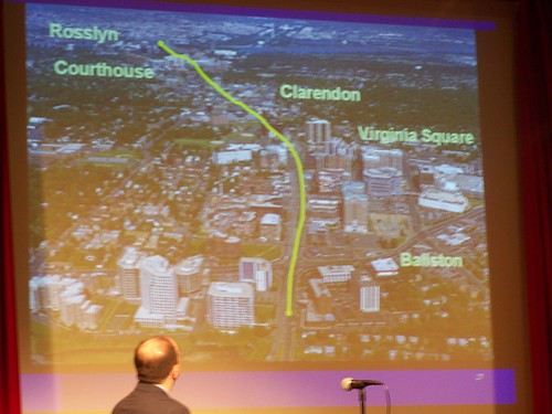
Arlington plan, dense corridor, low density residential outside the corridor, slide from a presentation by Chris Zimmerman of the Arlington County Board.
The Wilson Blvd. corridor of today represents not a 10 year process, but a process that started in the early 1970s--starting about 40 years ago--and it will take 15 more years to redevelop Rosslyn to fully reap the value of its location (which is being marketed by developers very heavily against DC), just as Crystal City is going through redevelopment changes now, and the county adds fixed rail transit.
Note that like much of Prince George's County, the urban design in Rosslyn and Crystal City hasn't been favorable to walkable urbanism, and wrenching changes are required to make those places work for the new future.
-- "For TOD to be successful, necessary antecedents are required, there's no magic wand," April 2011
In the meantime, Fairfax and Loudoun Counties, by getting the Silver Line subway line, have the opportunity to begin repatterning their urban design for the walkable 21st Century, while Montgomery County has already been investing in Bethesda and Silver Spring and Rockville and is redeveloping the White Flint/Rockville Pike area and Wheaton (see "Montgomery no longer a homogenous suburb" and "How to make Wheaton into the next Adams Morgan (or not)" from Greater Greater Washington) to reflect the new urban paradigm, emphasizing that DC and Prince George's County can't tarry too much if the jurisdictions want to remain competitive within the metropolitan landscape.
-- Short term vs. long term thinking: transit, the Washington Examiner, Fairfax/Loudoun Counties vs. DC," March 2011
-- "How to Kill the Center Cities, particularly DC: Phase 3," May 2009
Separately from the Pearlstein thesis, the Capitol Riverfront Business Improvement District released a report, Greenprint for Growth, about how development and intensification in association with the Green Line subway line is the next frontier.
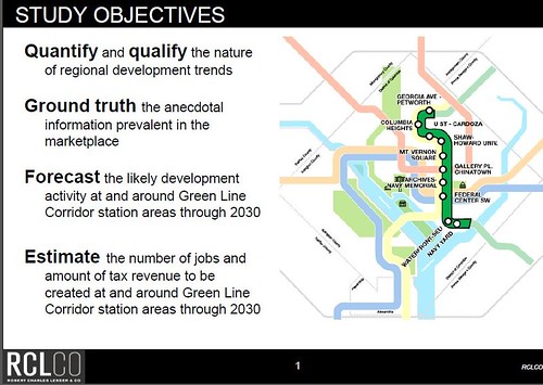
I haven't had a chance to read the document yet, but I do think it is interestingly constrained as the report only looks at the impact of the Green Line from the Navy Yard to the Georgia Avenue-Petworth stations (10 stations in all, and most of the areas around these stations have been experiencing redevelopment already, especially in the Downtown core), although this makes sense, because the organization that contracted the report primarily cares about its geography along the Anacostia River, and not redevelopment in distant places.
For example, I see the intensification that is happening at Fort Totten Metro Station in DC as a harbinger of the future no different than what Pearlstein writes about, but it does demonstrate a new development paradigm for DC, although it happens to be the same paradigm employed by Arlington County along Wilson Boulevard.
Except in how the Central Business District has extended to M Street SE (Navy Yard) and eastward to NoMA/Union Station, for the most part, DC hasn't significantly upzoned for more intense development the areas around subway stations that are outside of the core of the city.
Columbia Heights is an exception. And the area around the Petworth station is intensifying as well, with taller buildings, although there had been 5 story apartment buildings already, as a result of the earlier streetcar era.
This means you have two and three story buildings for the most part around Metro stations, at least so far.
Fort Totten is seeing an intensification that is fundamentally different. Generally, the Fort Totten area is marked by garden apartments and single family housing that is attached, detached, or in duplexes. It is a low scale development paradigm.
The first wave was nothing special, a set of 4 story apartments built on land across from the Metro. Many people, not just me, deride the buildings for their uninspiring design.
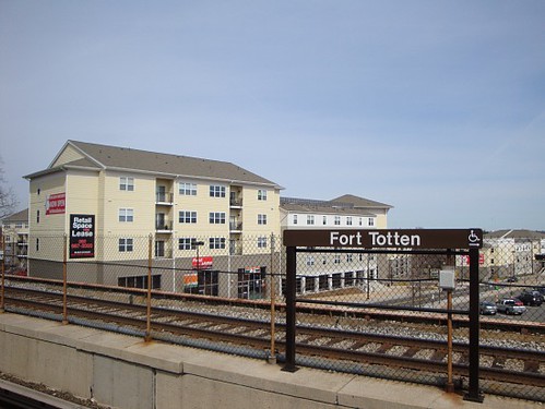
Image from the story, "Fort Totten: Five Years Could Make a Big Difference," in the Urban Turf blog.
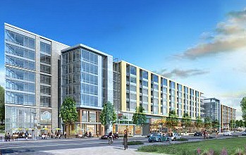
But the second wave is decidedly different, an intensification--for DC--of garden apartments owned by the Cafritz Foundation and a former strip shopping center that now is owned in part by JBG into buildings that are going to be 5 and 6 stories tall. Stores like Walmart will be coming to the area too. (Frankly, I prefer the concept as rendered by the previous developer.)
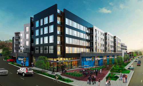
Top: Rendering of the JBG development on Riggs Road, Fort Totten. Bottom: rendering, Cafritz "Art Place" development.
I think over time this development energy will move outward within the DC catchment area of the station, as there is similar building stock present between North Capitol and Fort Totten Drive within easy walking distance to the Metro station, and in the areas abutting these developments, and even just across the border into Prince George's County where there is a large shopping center and a variety of garden apartment complexes that are close enough to Fort Totten that the proximity can be leveraged and marketed.
Similarly, when as Fort Totten builds out, development will jump to the area around West Hyattsville Metro, which has development intensification opportunities similar to that of Fort Totten--which face it, 10 years ago, people never would have believed that the area was capable of supporting the kinds of developments that are going into there now.
Etc.
Labels: mixed use development, transit and economic development, transportation planning, urban design/placemaking, urban revitalization, urban vs. suburban
posted by Richard Layman @ 5:43 AM&Permanent Link
![]()
![]()


0 Comments:
Post a Comment
<< Home