Educating the pedestrian vs. re-engineering road pavements to reduce accidents in pedestrian priority areas
Everything matters car commercial, Mercedes Benz.
But "everything doesn't matter" when it comes to the mobility system.
Enabling fast driving matters more than enabling safe driving. And by building the mobility system the same way in every place, regardless of land use context, by design, we create the nexus for conflict, accidents, and fatalities.

What the agencies have done is come together to create an information card, presented in hotel rooms, providing pedestrian safety tips.
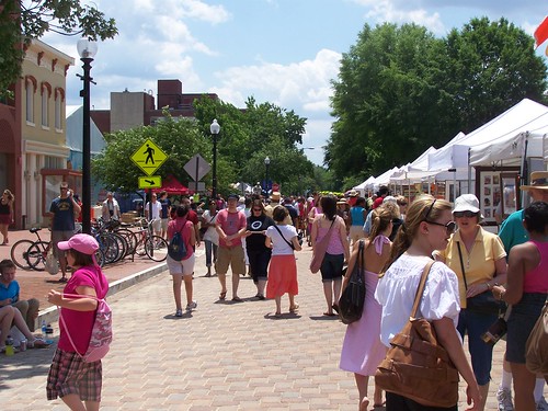
Gulf Boulevard in St. Petersburg Beach is a road with many hotels and visitors to the city walk along the road and between there and other destinations in the city.
It's been awhile since I've been to Tampa Bay, but Florida is like most of the US, so most people get around by driving, but in tourist areas, there is a preponderance of pedestrians, and therefore a greater opportunity for accidents, because most motor vehicle operators aren't accustomed to having to be concerned about pedestrian-motor vehicle interaction because where they usually drive, people don't walk.
data shows that from 2008 to 2012, there were 119 crashes and six fatalities along Gulf Blvd. The goal of FDOT is to reduce pedestrian fatalities by 20% by 2018, hopefully saving about 15 lives per year.

But where the disconnect is especially apparent is in those places where pedestrians make up a preponderance of the total "traffic" along the road. This is an issue in center city areas that mix residential and commercial uses in particular, but also around schools, parks, libraries, and in those places that are tourist destinations.

The Pennsylvania/New Jersey Smart Transportation Guidebook makes the point that "roadway characteristics, roadside charateristics, and operating speed regulations" for streets should be based on the land use context and whether the road serves local/community or through traffic.
Similarly, some state transportation departments have published guidebooks on this issue, such as the Oregon publication, Main Street: When a Highway Runs Through It.

But for the most part, these publications don't address road materials as a key element in creating the opportunity for accidents, because traditional methods and practices call for the use of asphalt and concrete in all instances, even though such materials enable high operating speeds for motor vehicle operators regardless of context and conditions.
This is abetted by the fact that cars are engineered to be able to go very fast.
What is needed is extraordinary guidance that challenges traditional orthodoxy on what materials to use to build roads when the roads are used by all types of users, not just motor vehicles, but by pedestrians, transit users, and bicyclists.
In the past, I've argued that by changing the pavements from asphalt and concrete to bricks and blocks we would provide visual, aural, and physical cues to motor vehicle operators that they should drive more slowly, so that their driving practice better fits the requirements of that area, rather than expect land use contexts to change in order to favor the power of the automobile.
See:
-- Pedestrian safety and the proposed 15mph residential speed limit in DC: Part One
-- Complete Places are more than Complete Streets
I am almost embarrassed to think of some of my writings on this issue in the context of Europe, which until last week, I had never visited. Certainly, I am familiar with the urban design elements of traditional cities, which have their roots in medieval practices, which have been maintained to some extent in the modern era. But seeing is believing.
I visited just a couple cities in Germany, but in Hamburg especially, the materials and textures for roads and sidewalks are very nuanced to communicate many things including:
- intersections
- driveways
- sidewalks
- bikeways
- turning traffic
- etc.

- street (asphalt)
- gutter
- curb (stone)
- driveway (stone block)
- sidewalk (light colored pavers)
- bikeway (red pavers)
With the use of such a wide range of materials and textures, in visual and tactile terms, the motor vehicle operator is "instructed" to drive more slowly and pay close attention.
In this manner the speed capability of the motor vehicle is mediated in favor of the pedestrian and bicyclist, which makes sense since pedestrians and bicyclists are much more vulnerable to cars than vice versa.
It's increasingly common in the US to re-engineer crosswalks with special pavement treatments, such as at 7th St. and Pennsylvania Avenue NW in Washington, DC.

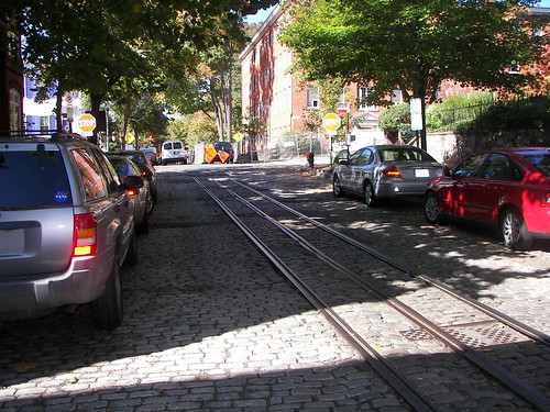
Here and there in the city there are legacy remains of asphalt block paved streets in Capitol Hill, and stone block and cobblestone (they look cool but are a pain to walk on) paved streets in Georgetown. And the city's transportation department agreed to repave one block of 7th Street SE from asphalt to pavers in front of the Eastern Market public market.
This will be extended one block to Pennsylvania Avenue when the Hine school site is redeveloped. I have also suggested that the treatment be extended south on 7th Street across Pennsylvania Avenue and around the Eastern Market Metro.
Eastern Market
P Street NW, Georgetown
But I argue that we need to re-engineer the pavement for the entire road in pedestrianized areas, just as is done in Europe. A crosswalk isn't enough.

While it's important to educate pedestrians on how to behave safely in traffic--probably the tourists in Tampa Bay don't normally walk much, just as motor vehicle operators are unaccustomed to large numbers of pedestrians--in all likelihood, the best response to "fix" the problem on Gulf Boulevard is to re-engineer the "roadway and roadside characteristics" in such a manner as to reduce pedestrian accidents and fatalities.
Note that the countermeasures prescribed in the protocols specified in the Pedestrian Safety Guide and Countermeasure Selection System and the BIKESAFE: Bicycle Countermeasure Selection System produced for the Federal Highway Administration do not prescribe significant urban design changes that would preference the use of different pavement materials for roads in predominantly pedestrian areas.
By doing this on such a prominent Florida street, the state department of transportation would communicate strongly the importance of pavement types as a way to mediate speed and reduce pedestrian and bicyclist accidents and fatalities.
Note that locally, the Maryland State Highway Administration should do the same kind of treatment in College Park, Maryland, home to the University of Maryland, where a highly trafficked arterial, Route One, splits the campus from the "town," many residential quarters, and the subway station, and has an equally vexing problem of mediating appropriate traffic speed with the land use context which is predominately pedestrian, combining the campus and student serving retail across the street. See the local tv news story, "College Park to Get Safety Improvements."
Labels: bicycle and pedestrian planning, car culture and automobility, roads, sustainable transportation, traffic engineering, traffic safety and enforcement, transportation infrastructure, urban design/placemaking
posted by Richard Layman @ 7:16 AM&Permanent Link
![]()
![]()


5 Comments:
has Ed Bryant seen this posting yet?
Don't really know him.
cf. http://greenlightpinellas.com/
This is another example of what I call "Signature Streets" type planning.
My "unified theory" of how to do transportation planning in terms of the "integrated public realm framework" is moving along...
umm, if he wants, we could jointly write an op-ed for the Tampa Bay Tribune...
Richard, welcome back.
And welcome to the "Europe does it better" bandwagon. Althoough I've always suggested a better model is Canada or Australia, which have extremely succesful urban environments and similar regulatory and land-use patterns as the US.
I think part of the problem is we have a "One size fits all mentality". For example, think of snow clearing those pavements.
Or maintaining them!
And even a city-state such as DC, which doesn't have the burden of state highway department, is sucked into that vortex. Ft. Meyer construction is not suited to the urban environment. Except for employment practices....
And you remember the noise that was made when people along Q in Georgetown maanged to get those blocks replaced at 10x the usual price.
Yes, one size fits all is very debilitating. That's the difference between Europe and the US. Been to Canada enough, never to Australia. The difference (see my nat. bike strategy post) is that it is more urban. But it's tricky. The federal-provincial thing is very different there. Limited federal money for local transit (which you would like), but the provincial governments can be just as f*ed up. For decades, BC was very conservative e.g. so that Vancouver has been an outlier, etc.
But yes, I "knew" intellectually that Europe did this better. When I first got heavily involved in this stuff, I was much influenced by a lot of the work out of Britain (English Partnerships, CABE, the various govt. agencies), so it wasn't just continental Europe.
But then when you see it at the block level, and face it, I wasn't in East Germany, I was in West Germany, it's pretty amazing.
But like Essen... it's a bit smaller than DC, but has a "new" underground + a wide ranging tram network + the regional rail run by DB. Granted, the intra-Ruhr transit has gaps. Different gauges between tram systems of the major cities (like Bochum) mean that the system doesn't interlink in the same way that it does in the city-state of Hamburg and the nearby states that participate in the regional transit operating system that is anchored by Hamburg.
But they have an underground and a tram. If DC weren't the national capital, it wouldn't have a fixed rail transit system...
Post a Comment
<< Home