Complete Places are more than Complete Streets (reprint)
This is a reprint from October 2010 and I think it's equally relevant today ("evergreen") given all the various discussions here and around the country (NYC, Atlanta, etc.) about pedestrian safety.
The biggest reason that pedestrian deaths aren't falling is that more people are walking and even in "walking" cities like parts of New York City or Washington, DC, the reality is that the mobility network is shaped in ways that privilege motor vehicle operation. More importantly, the road system is set up to enable motor vehicle movement at high speeds.
More pedestrians + the same amount of cars and no change in attitudes about the privileging of the car = more accidents
So what is needed is a re-centering of the field around making modes (active--walking, biking, scooters, skateboards, roller blades, motor vehicles, transit) more equal if not "co-equal" in terms of leveling the playing field.
Monument Avenue, Richmond
This also comes up in my greater neighborhood, where two streets--Piney Branch Road and Blair Road--are simultaneously arterials serving as part of the regional road network (between DC and Montgomery County, Maryland) as well as neighborhood-focused serving the immediate community. The problem is that these roads have never been "re-engineered" to handle these often conflicting uses, and they retain a lot of their "country road" roots--e.g., from Cedar Street to the DC-Montgomery County line, it's a two-lane road (one of the few stretches of road in DC or Maryland that I won't cycle on when there is traffic, I get on the sidewalk).
Because of a streak of recent accidents, it's being discussed again on the neighborhood listserv. Of course, as I wrote, "repeated problems/undesired outcomes are "indicators" of systemic failure/problems in systems, structural-organizational conditions and process."
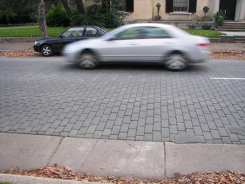
FWIW, my "solutions" are to underground North Capital-Blair Road which I wrote about in 2011 and to repave a significant section of Piney Branch Road in asphalt block.
For another "project" I am working on, I have come to realize that in DC, we don't have "ward-specific" transportation agendas-lists of projects and opportunities for innovation at that scale, big plans notwithstanding.
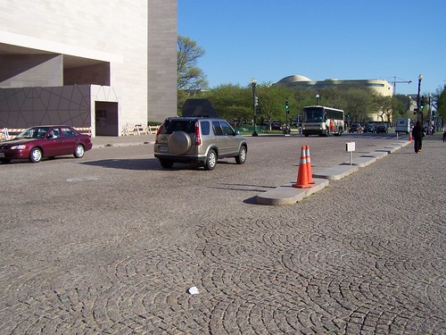
Stone paver street between the East and West buildings of the National Gallery of Art.
[And I have further developed these ideas in the "Transit, Stations, and Placemaking" (2013) and "Silver Spring and layering effect" (2012) posts.]
A press release from DC's Department of Transportation went out recently, stating that the agency has adopted a Complete Streets policy.
Typically, a complete streets policy means that the transportation agency plans for comfortable movement for all modes within the street network. Basically, it means that walking, biking, and public transit are to be accommodated in complementary and equal fashion to how planning typically emphasizes motor vehicle traffic.
While I haven't come up with a better term, sometimes I say "Complete Places," and the Project for Public Spaces has a training workshop on "Streets as Places," there is more than a "complete street" to a complete place.
[Note: now I would say my preferred term is "Signature Streets" which are outlined at the end of this entry on transit, based on work I did in Baltimore County and.]
It has to do with how other government agencies prioritize funding and where they choose to invest scarce public resources, and how capital improvement programs work and whether or not the various agencies coordinate their efforts.
For example, the District of Columbia Government:
1. Doesn't coordinate capital improvement programs according to what we might consider Complete Places practices. E.g., the Gazette has an article about a combined library and recreation center coming to Wheaton ("Officials present plan for combined library and recreation center"), and Montgomery County and Arlington County have a number of such projects, including the Rockville Town Center, which includes a public library, other county facilities, and the VisArts nonprofit visual arts center.
How Arlington County redid the Shirlington Library to include the Signature Theater, which in turn became a key cultural asset for the Shirlington commercial district and extended the viability of the commercial district by increasing the number of visits and ancillary spending, is an example of how to coordinate capital improvements with a complete places program. (See "Savoring the Sunbeams in Shirlington" from the Post.)

Shirlington Library and Signature Theater.
Another example is how the DC Dept. of Housing and Community Development sold a piece of land for a hotel at Michigan Avenue and Irving Street NE, when instead investment in that area should be focused on revitalizing and improving the Brookland commercial district--now on 12th Street NE mostly, but also extending and recentering on Monroe Street and around the subway station. [Note: that happened in 2007 but the hotel project still hasn't moved forward.]
Another example would be the plans for Walter Reed redevelopment. I know that there is a lot of land and people want to develop it, but by creating yet another area of retail development along Georgia Avenue in addition to the other nine marginal commercial districts along Georgia Avenue (around Howard University, around Park Road, at the Petworth Metro Station, at Upshur, at Kennedy Street, at Missouri Avenue, at Piney Branch Road, north of Walter Reed, at the City-County line) doesn't improve the extant commercial areas. According to the Post article, "D.C. to unveil plans for redevelopment of Walter Reed," 200,000 s.f. of retail will be built on Georgia Avenue on the Walter Reed campus -- in addition to the more than 1,000,000 s.f. that already exists and is mostly marginal.
2. How about an overall complete places policy and initiative? We need a Complete Places/Placemaking Initiative for the entire city, not unlike Placemaking Chicago.
Dan Malouff wrote a really really great piece in Greater Greater Washington last week, "Let's convert Scott Circle into Scott Square," opining about how Scott Circle could be reclaimed and rebuilt into a square, with a much greater sense of place. This extends ideas expressed in the improvement of Thomas Circle by DDOT a few years ago, and how Logan Circle regained its original footprint in the 1970s, after losing parkland to more roadways.
Thomas Circle improvements are shown in the entries on Truxton Circle.
Relatedly, the Tommy Wells blog mentions that DDOT plans to plop some more traffic calming measures around Lincoln Park. See "Details on New Raised Crosswalks at Lincoln Park."
And, there is an initiative to make Connecticut Avenue safer for cars. See "What would make Connecticut Avenue safer for pedestrians" from Greater Greater Washington.
And a couple years back, someone proposed bringing back Truxton Circle in the Bloomingdale neighborhood. See "Before and after: Truxton Circle" and "What a "Complete Places" land use and transportation planning philosophy would mean in practice."
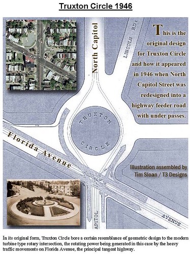
Image by Tim Sloan.
[In response to neighborhood complaints] Probably the best thing that could be done to traffic calm the area around Lincoln Park would be to replace all of the pavement with asphalt block. This is comparable to how parts of South Carolina Ave. are paved, Monument Avenue in Richmond, or how more expensive granite pavers are used on 4th Street between the east and west wings of the National Gallery of Art, and in public squares in many European cities.
900 block, South Carolina Avenue SE.
I know it's expensive. But I think, at this time anyway, it's about as close as we can get to woonerfs in the U.S.
The visual, aural, and physical cues would slow motor vehicles down.
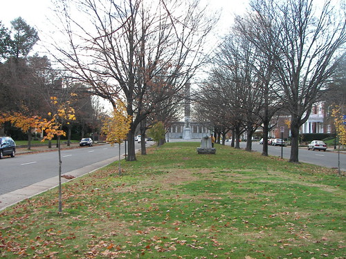
The median strip (boulevard) on Monument Avenue, Richmond.
While I have thought this should be done around parks for a long time, discussions over the years with community advocate Andrew Aurbach led me to believe this should be done around all park squares/circles (including Stanton Park), schools and other civic buildings used by the public (libraries), and commercial districts.
Andrew [...] is one of the leaders of the Connecticut Ave. pedestrian initiative.
3. Somehow, a "Complete Streets" and a "Complete Places" policy has to address the centrality of parking as driving neighborhood planning. People's focus on parking makes it really difficult to improve neighborhoods. The ironic thing is that the focus on parking for cars means that people neglect to focus on placemaking and livability overall.
Charging higher prices for parking, and as Christopher suggests in a comment to a previous entry, directing that money to transit and other public realm improvements is the way to go.
4. The way to think about this is in terms of what David Barth of AECOM calls an integrated public realm, in the presentation Leadership and the Role of Parks and Recreation in the New Economy. That's the kind of citywide initiative we need!
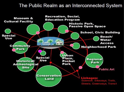
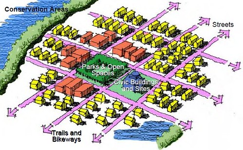
The red buildings in this image depict commercial districts. David Barth images.
------------------------------------------------------------------------------
From the DDOT press release:
Complete Streets Policy
I. Policy
a. The District’s transportation network as a whole shall accommodate the safety and convenience of all users, recognizing that certain individual corridors have modal priorities. While these priorities should remain and be encouraged along specific corridors, connectivity throughout the network for users of all modes is essential. Examples of modal priorities include, but are not limited to, residential streets, green streets, school routes, and corridors that are important to transit, freight, commuter traffic, and retail;
b. All transportation projects shall reflect the land-use, transportation, and green space needs of the city-wide transportation network, be sensitive to its various contexts, and should improve, not diminish, network connectivity;
c. All transportation and other public space projects shall accommodate and balance the choice, safety, and convenience of all users of the transportation system including pedestrians, users with disabilities, bicyclists, transit users, motorized vehicles and freight carriers, and users with unique situations that limit their ability to use specific motorized or non-motorized modes to ensure that all users can travel safely, conveniently and efficiently within the right of way;
d. Pedestrian, bike, and transit Level of Service (LOS), in addition to vehicle measurements, shall be evaluated to ensure proposed alternatives balance, as appropriate, the needs of all users of the right of way.
i. The planner or designer shall calculate and design for an appropriate combination of LOS that accommodates all users;
ii. The planner and designer shall also refer to previously established plans to ensure consistency;
e. Wherever possible, projects should help DDOT achieve goals as set by the Action Agenda or subsequent strategic plan;
f. Improvements to the right of way shall consider environmental enhancements including, but not limited to: reducing right-of-way storm water run-off, improving water quality, prioritizing and allocating sustainable tree space and planting areas (both surface and subsurface), reusing materials and/or using recycled materials, and promoting energy conservation and efficiency wherever possible;
II. Procedures
a. The aforementioned policies shall be employed in all transportation planning, design, review, operations, major maintenance projects (such as milling and overlay), new construction and reconstruction projects, except where prohibited by federal and District law (such as interstates, non-motorized trails);
b. Routine daily maintenance and operation activities (such as potholes and cracked ceilings) are specifically exempt from this Policy. Any other exceptions require written justification, documentation, and approval by the DDOT Director or Delegate. Exceptions may be granted based upon documented safety issues, excessive cost, or absence of need.
Labels: bicycling, car culture and automobility, transit, transportation planning, urban design/placemaking, walking
posted by Richard Layman @ 10:59 AM&Permanent Link
![]()
![]()


7 Comments:
I love Shirlington--it's where I discovered Luna Cafe--and what was done with Signature and the library. In the three-plus decades I've been going there, I have never seen a bicycle anywhere on the property. It is accessible almost exclusively by car and is a suburban mall model.
Also, on the complete places or streets concepts, I am an avid follower of Yogi Berra's philosophy: "In theory there is no difference between theory and practice. In practice there is." That is to say, in its zeal to drop bike lanes all over the downtown area--where I happen to live--to accommodate cyclists, DC clearly didn't consider that this might have added significantly to the pedestrian hazards already present from automobiles.
In fact, my experience as a pedestrian over the past 12 months, has included burgeoning numbers of offensive and dangerous cyclist actions.
-EE
I am preparing (mentally) a piece on the gaps in "enforcement" as one of the 5/6 E's of bike and pedestrian planning, but focused on biking.
I argue for
1. legalizing the Idaho Stop for bicyclists.
2. But then seriously enforcing "running" red lights, stop signs, and yield signs in the face of oncoming traffic including pedestrians.
3. way better training for cops generally
4. and for accident investigation
5. the Dutch system of legal responsibility for accidents, putting much bigger responsibility on motor vehicle operators for accidents, financially and legally.
6. training for prosecutors wrt enforcement, penalties... although it'd be hard because most juries are made up of a majority of motor vehicle operators, who would think "it could have been me" and won't give a guilty verdict.
umm, the first Luna Cafe was in DC.
"umm, the first Luna Cafe was in DC."
Apologies, meant to say Luna Grill...and, yes, it's still there. But I didn't go to the one on Connecticut Avenue until two decades after I first went to the Shirlington Village Luna Grill & Diner and finally discovered there was a branch in DC. My first attempt to visit the DC branch of L,G&D was foiled when we went by mistake to the similarly-named Cafe Luna up on P Street--really blah food and kinda grungy.
I finally got there in the early aughts and have gone back numerous times. My comment still stands--Shirlington is fab, but it is not in any sense urban. It's a little slice of "Pleasantville" in the VA suburbs.
-EE
Anybody who hasn't noticed a bike in Shirlington over the past 30 years wasn't paying attention. It actually used to have a bike shop, and Best Buns had cyclists on their logo and t-shirts. There are bike racks at the transit station, bike lanes on the periphery, and a bridge across 395 for bikes and peds that connects to the Four Mile Run trail. I have not ridden since the new more direct connection has been built. The excellent youth bike program and shop Phoenix Bikes is nearby, well-connected by paths and trails. I worked in Shirlington for 5 years in the early 90's, and lived a few miles away for nearly 20 years.
It is not perfect, but it is legitimately urban, and has increased as such since it allows the opportunity to live, work, and shop, with good recreational opportunities, cultural amenities, and multi-modal transportation. It is indeed more urban than even many places in the District. EE is obviously a DC resident, where anything on the other side of the Potomac is "the Virginia suburbs" and Arlington is still seen as the place where the well-off Georgetowners and upper Northwesty types would go get their cars fixed, and go slumming for some Vietnamese food.
P.S. Luna Grill is not good and hasn't been for a very long time.
Good luck with enforcement as your magic bullet. And at least with cars, it is fairly easy to identify vehicles and license plates--with bikes, it's almost impossible.
The numerous instances of daily bad/reckless cyclist behavior that--both as a pedestrian and auto driver--I have witnessed are going to take a sea change in attitude. Currently, there is a huge sense of entitlement on the part of cyclists in their interactions with motor vehicles. Pedestrians are relgated to just so much collateral damage.
-EE
@anonymous 9:10 pm
You are correct that there WAS a bikeshop at Shirlington, but in all of my visits (starting in the early '80s)--and they were plenty since I was a daytime patron of a typesetting operation there regularly for several years in the '90s for my business--I never saw anyone arriving or leaving by bike, in or near Shirlington Village. One day, I did see a motorist drive up and park in front of the shop and bring his two bikes in for repair.
As for the remainder of your rather insulting remarks and erroneous assumptions about me extrapolated from my comments, my mother had the perfect suggestion:
If you can't say something accurate, keep it to yourself.
-EE
Post a Comment
<< Home