Minneapolis North Side Greenway project as a quantum leap in transportation-placemaking-greenway-trail-parks planning
I am proud of my "Signature Streets" concept, which makes the point that communities need to acknowledge the foundation of their primary transportation network and ensure that it is high quality in all dimensions, for multiple modes, and in terms of the placemaking, aesthetic, and architectural qualities, as an element of civic architecture.
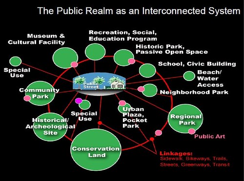
A lot of other people's work has influenced the development of this idea, particularly parks planner David Barth, whose earlier
(1) "City Revival" approach recommends that city's treat streets as "linear parks," which is an extension of the parkway road concepts developed by the Olmsteds and others;
(2) Barth's later concept of the integrated public realm framework (below) which helps to unify our thinking about civic assets as the fundamental building blocks of our local community and government;
(3) funding and large scale project development programs like Seattle's Bridging the Gap and Oklahoma City's Metropolitan Area Projects;
(4) the use of design as a key element of community branding and identity systems;
(5) the re-focusing of public investment on existing places; and
(6) the effectiveness of investments in transportation infrastructure especially as a way to move revitalization forward more quickly.
The development of the North Side Greenway in Minneapolis is a perfect illustration of taking the Signature Streets concept from theory to practice.
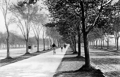
 Midtown Greenway. Flickr photo by Payton Chung.
Minneapolis is "lucky" in that it had many railroad corridors crossing the city, most of them in trenches, and over the past couple decades some of these corridors have been transformed into Greenways--shared use paths--that provide dedicated throughways for bicyclists and pedestrians that are fully separated from motor vehicle traffic.
The Midtown Greenway is perhaps the most successful, and is known for having the Freewheel Cyclery shop and cafe directly on the trail.
The greenway system is becoming a notable and desirable amenity and a number of multiunit unit residential buildings have been or are being constructed adjacent to it and touting the proximity and access ("Uptown building to get a multimillion-dollar addition," Minneapolis Star-Tribune).
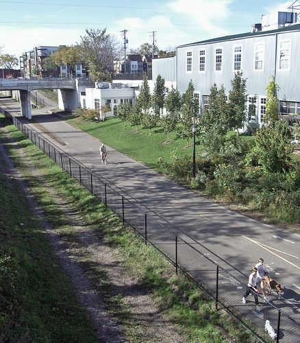
More recently, the Dinkytown Greenway opened, providing access to Downtown from the University of Minnesota campus ("New Dinkytown Greenway open for bikes, peds" and "New U bikeway fills an important metro link," Star-Tribune).
But what do you do for those parts of Minneapolis that don't have railroad trenches that can be converted to dedicated trails?
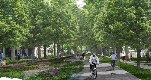
The Minneapolis North Side Greenway concept addresses this by proposing to create a greenway (or parkway) by repurposing and reconstructing almost 4 miles of existing surface streets into a greenway route that will connect the Victory Memorial Parkway, Crystal Lake Cemetery, Folwell Park and North Commons Park through the creation of a "linear park" or "parkway." See "Proposed North Side greenway encountering some bumps" and "Greenway options on display for North Side" from the Minneapolis Star-Tribune.
Because of the need to acccommodate current mobility expectations, they aren't able to create a 100% dedicated greenway. Instead they propose three (really four) different treatments. One is total greenway. One has one way traffic and parking with greenway or a narrow two lane street for through traffic, no parking, The third treatment is an enhanced bike boulevard with on street motor vehicle traffic.
Rendering of the proposed full greenway treatment.
Rendering of one version of the street + greenway treatment.
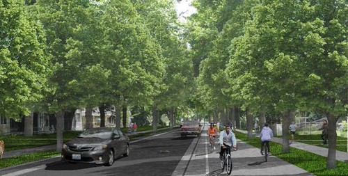
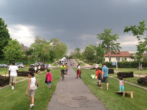
Illustration of what the greenway concept could look like in real life, as demonstrated on Humboldt Avenue North at an Open Streets event, May 31st, 2014. Minneapolis Star-Tribune photo by Eric Roper.
While there is some opposition to the project, because of the' existing greenway network, the proposal is less controversial than it might be otherwise, because people already are familiar with the concept, many have used the greenway network, and more people understand the value of these kinds of public investments as an element of community revitalization.
.jpg)
Labels: bicycle and pedestrian planning, car culture and automobility, change-innovation-transformation, parks planning, public realm framework, urban design/placemaking
posted by Richard Layman @ 10:05 AM&Permanent Link
![]()
![]()


16 Comments:
Richard,
I really appreciate your entire blog, but it is these posts that really stand out for someone like me who is into planning and kind of an urban history/public realm nerd.
Anyway, this is one of many times that you have mentioned that presentation from David Barth from AECOM, and I have been trying track down a copy of it for some time but to no avail.
Is there any chance that you could provide a link to it? I believe that the prior link from years past no longer works. That would be great to go through that presentation ...
Send me an email and I can send it to you. It's a pdf of his presentation at the Park Pride conference--which I came across about 2 weeks after I had finished up in Baltimore County, when the Signature Streets concept was very strong in my head still.
2. Remember though, that in some respects I have extended and built upon the ideas. His City Revival stuff I saw in a presentation at the APA in 2004. Unfortunately he never produced a textbook (I got on him on that and I think it was one of the goads for him to get a PhD, but he's into sustainability now.)
3. And while it will take me awhile to produce it, I have built on that diagrammatic framework to come up with a transformational framework for approaching how to do planning more generally, including equity planning.
Although I am going to have to learn InDesign I think, in order to be able to redesign and extend the graphic into the new way more complete framework and express it graphically as well as in words.
4. This is one of the only in print discussions, in the appendix of the parks and rec plan for Tampa circa early last decade, of City Revival,
https://web.archive.org/web/20110728102457/http://www.theplanningcommission.org/tampa/tampacompplan/supporting-documentation/7_Parks_Recreation.pdf
I forgot to mention that City Revival was based on City Beautiful and New Urbanism.
Thank you so much. I would be really interested to read your extension of that framework. I live along Rhode Island Ave NE and when reading things like this, as most people probably do, I always imagine the changes that could be made to my neighborhood and the District in general. Particularly when you are talking about the importance of signature streets, the need for high quality public space and architecture, and transit as a catalyst for revitalization.
About InDesign ... Even if not specifically required for your project, it can be extremely useful. It has many of the same features as Illustrator and some of the same features as Photoshop and, most importantly, it can be used as your primary writing program once you get the hang of it. After the steep learning curve (at least for me) InDesign becomes a much, much better tool than Microsoft Word.
There are a lot of great self-paced courses at Lynda.com, and while I don't think it is in print any longer (just online) the InDesign Secrets magazine and website is a great resource.
Just eyeballing it, the trees makes the biggest difference.
I wonder with electric cars whether there will be a push for shared parking (with charging).
Alleys in DC could provide a similar function. They seem mostly to be rebuilt and used for garbage.
how are you thinking of this? Can't quite visualize it. But obviously, it sounds interesting.
shared parking? just a structure at the end of the block for 10-15 cars. Or underground it.
And then just a bike lane or that funny dutch word for access to the house.
And you probably laughing at me right now, because I am suffering from the alley rescontruction blues. We really needed a green one here.
Ahh. Makes sense.
2. wrt the alley, tell me which one and I'll check it out/photograph it.
DC got rated as 3rd most sustainable city in the US. I haven't read the press release or the methodology yet, but I think it's likely heavily weighted to LEED buildings and self reportage on agency operation.
the alley reconstruction program, "waste" collection procedures, etc. demonstrate a failure to inculcate sustainability thinking.
However, I have seen more installation of green sidewalk treatments around trees, although it appears as if they are still experimenting.
Between 11th and 12th NW. South of Florida.
Huge problem with overflow -- mostly from badly designed roof drains.
In terms of alleys, the crews they hire (capital paving? Ft Meyer?) are probably not capable of doing more sophisticated work.
will check it out. When was it repaved?
"However, I have seen more installation of green sidewalk treatments around trees, although it appears as if they are still experimenting."
Hm-m-m. If you're talking about those fancy metal tree boxes that have been installed around many of the downtown street trees that are chock full of plants, these are not green.
The other completely "ungreen" thing that UFA needs to nip in the bud is the "Tavern on the Green" wrapping of trees with decorative lights. [As an aside, when I first walked the new City Center after it had been landscaped, I was thoroughly appalled that every new tree on the perimeter was wrapped.] It strangles the trees and dramatically cuts their life spans.
DDOT did install an interesting rain garden on all four corners of 19th and L Streets NW. Years ago I quit walking along L Street east of 23rd in the summertime because the sewer gas smell was so bad. This may be helping
-EE
Well they are repaving it this week.
Old pavement was brick. It was in very poor shape and I'm surprised the garbage trucks could even navigate it.
They ripped that out, dug down about 6in, put in a concrete layers, and are then doing to do a final surface.
As we talked about, a lot less sophisticated that the green alley treatment.
The water overflow is very bad because of drain gutters than empty on to the alley. That is why the previous surface was destroyed.....
EE -- nope. Various rubberized treatments, that flex as roots grow. First they used more rigid treatments. Now much more flexible. I'll try to blog a couple different treatments.
To be honest, I saw last night they are putting brick down over the concrete.
Two other thoghts:
1. My part of FL aveneue could easily be convered into one of these greenways.
2. The divide between DC and DC water is part of the problem.
Very good point about WASA, and about "Metropolitan water authorities" generally.
E.g., in Seattle, Seattle Public Utilities pays for some of the greening projects. It's fully owned by the city, doesn't provide service to any other jurisdictions.
By contrast, WASA, and Baltimore DPW and the water authority in Detroit, provide some services to other jurisdictions (e.g., with WASA, water and sewage treatment to Fairfax and another jurisdiction), and so the other jurisdictions end up "feeling" that doing city-specific utility related public space improvement projects are somehow partially funded by the suburbs, and so it can't really happen.
OTOH, whereas I see it making sense that SFMTA does street projects or has the parking enforcement part, others see that as a transit agency subsidy to other city functions.
Oh, and SPU helps fund community service points in libraries, in part because people can pay their utility bills at the window...
Post a Comment
<< Home