Another example of a discoordinated transit system in DC proper: maps in bus shelters
I wrote last week about how the various separate BRT planning efforts around the metropolitan area are an example of a lack of metropolitan-scaled transit planning. The maps displayed in DC bus shelters are another example.
DC has four types of bus transit service. The primary service comes from Metrobus, the bus service delivered by WMATA, which provides the bulk of intra-city bus service on major and minor routes and some transit between DC and other jurisdictions. (Many of the lines end at the boundary between DC and Maryland, reflecting age-old service patterns.)
Unlike the suburbs, DC doesn't provide an extensive intra-jurisdictional bus network separate from WMATA, but the five-route DC Circulator is an example of such a service. (Note that in a couple of instances, RideOn, the bus system for Montgomery County, provides service to DC locations, including a route to Sibley Hospital.)
The third public transit service is inter-city long distance bus commuter service from distant locations in Maryland and Virginia. Maryland Mass Transit Administration coordinates this service on the Maryland side, while Loudoun County, Prince William County, and the Fredericksburg area each provide commuter bus services from Virginia.
A fourth service is the various shuttle services provided by government agencies, businesses, and other institutions. Shuttles operate between buildings, campuses, and Metrorail stations mostly. Major examples include universities like American, Gallaudet, Georgetown, and Howard, the Smithsonian, and Washington Hospital Center. These systems are not fully public, and are open only to employees, students, patients, etc.
Except for WMATA-owned station properties, the bus shelters in each of the local jurisdictions are run by the respective jurisdiction. So DC is in charge of the city's bus shelters.
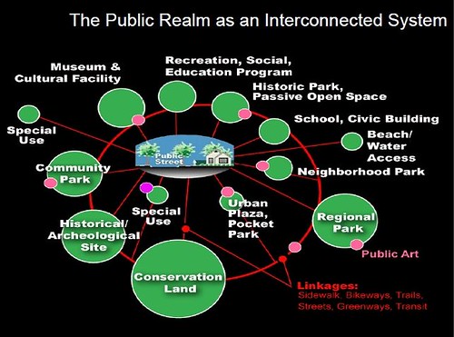 Transit shelters as a marketing touchpoint. From "Arlington County's bus shelters and a public realm framework of quality":
A point I make is that bus shelters are the primary marketing touchpoints for transit, for users of the system as well as for non-users, who travel by and around the bus system and its physical manifestations. The information posted in shelters about bus service markets the service--or not.
You see this attention to the service as a whole and its marketing and branding aspects, in the implementation of bus rapid transit service, where they tend to focus especially on providing modern, attractively designed bus shelters and quality information services ranging from real-time arrival information, wayfinding in the stations, and marketing of the service.
More recently I have extended these arguments about the quality of the physical and wayfinding elements in the transit system, influenced by a concept articulated by David Barth (now of AECOM) which he calls the "integrated public realm framework." ....
(1) transit riders deserve high quality amenities and infrastructure too, such shouldn't be the exclusive province of motor vehicle operators;
(2) transit shelters are an integral element of an integrated public realm framework;
(3) transit shelters are key touchpoints for marketing transit, especially surface transit.
 Proof of concept business district wayfinding signage. Many years ago, Christopher Taylor Edwards and I created a conceptual business district map that among other elements, showed transit routes using the same graphic design treatment WMATA uses on their own map products.
Even WMATA's bus shelter maps use a different design treatment from the Metrorail map. I think that's a mistake.
Lack of common graphic treatment across different map products. Maps produced by entities other than WMATA don't use the WMATA design treatment, other than the colors of the lines and the M Metrorail symbol. The variety of methods mostly fail--not the Circulator, because it depicts lines showing complete bus routes, but only of its own routes.
The maps displayed in bus shelters that are served by multiple local bus services should include information on all of the bus lines that serve that station and the sub-city district served by the station. For many of the transit stops, this is not the case.
Sub-city transit mapping. When the new system of bus shelters were launched in 2006, local business districts and neighborhood associations were given the option of putting in localized maps and promotional information in the shelters, but outside of the business improvement districts, most haven't had the financial ability to pull it off. DC didn't think to set aside money from the shelter advertising contract to assist local districts in providing such information.
There are three types of maps displayed in DC's bus shelters. Most are provided by WMATA and show bus routes serving the transit stop and the city . The second type are maps of the DC Circulator bus system. The third type are business district maps, mostly created by Business Improvement Districts.
At least in Downtown, WMATA maps don't show Circulator routes, Circulator maps don't show WMATA routes. And the Downtown BID map doesn't show the Circulator either, even though an entity managed in part by the Downtown BID runs the Circulator bus service!
The Downtown BID map doesn't have bus and subway route lines on the map either, which makes it very difficult for people to get their bearings.
The photos are the Downtown DC BID map at a shelter at 7th and E Streets NW; a WMATA map on 7th Street at the Archives Metrorail station; and a DC Circulator map at a combined WMATA/Circulator bus stop at Massachusetts Avenue NE at 3rd Street.


Maps aren't provided at bus stops for the long distance commuter services. Only recently have these services been more consistent in putting up bus stop signs. The presumption is that people who want to use these buses already know about them.
MTA produces a single map showing all their commuter bus services, but there is not a comprehensive map on the Virginia side showing all of their long distance commuter bus services on one map.
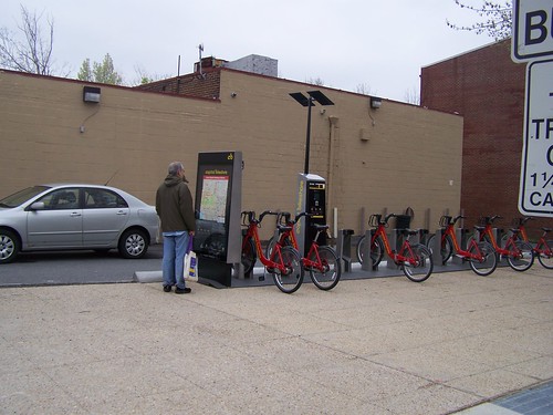 Maps at bike sharing stations end up being used by pedestrians as well.
The area's bike share stations have their own mapping system, while bike share station maps in cities like London and New York are elements of the city's overall wayfinding signage system.
DC's wayfinding signage system is not nearly as comprehensive as other systems, and is complicated by the fact that various federal entities like the National Park Service, the Architect of the Capitol, and the transit agencies have separate systems.
Note that the comprehensive wayfinding signage system developed in Bath, England is the model and foundation for larger systems in London and New York City.
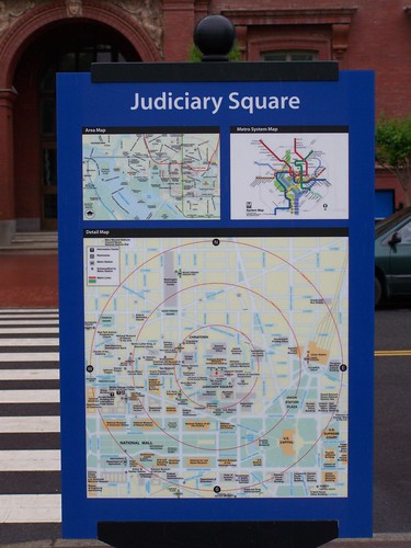
Showing walksheds on bus shelter maps. Maps in Metrorail stations show the walkshed from the station at one-quarter, one-half, and three-quarters of a mile--5 minutes, 10 minutes, and 15 minutes.
Some signs in the DC wayfinding signage system are posted outside of stations. Intended for use by tourists, these maps include walkshed information.
Bus shelter maps within districts such as the Central Business District/Downtown should also show walksheds. Some people will find it faster to walk to a destination than to wait for a bus.
Conclusion. Sadly, at the intra-city scale, as reflected by transit maps used in the city's bus shelters, transit planning can be as dis-coordinated as it is at the metropolitan scale.
Labels: public realm framework, transit marketing, transit wayfinding, transportation planning, urban design/placemaking, wayfinding signage systems
posted by Richard Layman @ 7:00 AM&Permanent Link
![]()
![]()


15 Comments:
Those BID bus shelter maps don't feature bus routes because they're not bus maps at all. This is a purposeful decision. WMATA provides the bus maps, the BIDs provide pedestrian maps.
... yep. But as pointed out in the entry (and I expected you to respond), they are either-or.
So if there is a BID map, there isn't a bus map provided by WMATA.
If there is a bus map from WMATA there isn't a Circulator map, even if the shelter serves both systems, and vice versa.
SO if maps don't show bus routes, don't show the Circulator routes, etc., they are not communicating a significant amount of needed information.
If the ultimate point is to serve the user, this is what a design professional or engineer would call a design failure.
It's not the only one. It also extends to provision of parking information by the Downtown DC BID and others (on the website). I wrote about this somewhere, maybe just in a comment thread on the "transportation stories of 2015."
Think about it from the perspective of the user, and how other best practice transportation information is communicated, and plan and implement accordingly.
I stand firmly on what I wrote.
Go look at the bus shelters yourself.
(Note that I didn't talk about the stanchions and some have maps with schedules. Others don't. Some have the LED info boards, others don't.)
Isn't that his point -- that having multiple entities provide this information in silos isn't helping to the end-user?
(and I won't even point out that the bikeshare stations also have maps)
I'd say a lot of these maps are going to be downgraded in mobile-phone age.
But yes same problem on say Google Maps. If I look for a bus route it across town it usually gives me a commuter bus.
The API switch on the part of WMATA for instance, seems to be screwing with the electronic signs on circulator availability. I"m seeing a lot of problems there.
That said (in person vs mobile) I'm always amazed by the number of people who stop and read the U st history signs. You can probably make that experience a lot richer.
Probably this will change over time to become more mobile centric. I am from the time of hard copy maps (I even collected gas station maps as a child), and I get very frustrated at how long it takes to load a map on a smartphone.
But I think as the smartphone generations succeed and "take prominence" over print-centric generations like mine, printed maps will get used less, will be needed less, even if they will still be a faster way to get the information.
Nevertheless, one of the most important books I read on marketing is called _Maximarketing_. Now what it discussed would be termed "omnichannel marketing." The point of omnichannel is to do your best to treat each channel excellently, not take any for granted, and to not blow off significant channels because of spurious reasons.
The point about transit shelters as marketing touchpoints remains.
But the other in terms of marketing such information is that you need to provide multiple forms of information in order to reach the greatest
possible audience.
People are finally "reached" via a wide range of media and "advertisments"/placements, and not necessarily when you do it, how you intend they get reached or consume the information.
Like with bike planning, it's not my job to reinforce my biases about how I think people "should" bike into a plan, it's my job to systematically assist people in biking transportationally by providing appropriate programming and responses based on demographic and household type of the potential user segment.
The same goes with map products and similar types of information.
Considering how important tourism is to the DC economy, it is amazing how badly we provide this information compared to better practice communities in terms of visitor centers, visitor information, map products, websites, wayfinding systems, etc., at all scales (metropolitan area, city, sub-city) within the city.
Again, I might not be a good planner, but I am good at gap analysis and comparison of communities.
with your point about the trail-history signs, my idea was to incorporate directory information, sub-district information, as part of them, maybe with a four sided kiosk.
That's why the sign examples Christopher and I developed fit into the existing format, although I liked "Explore" better than "Discover."
The point about "proof of concept" is that I kept "arguing" with people that we need intra-district directory info but they never seemed to get what I was saying. So we made the signs to show them.
Note that Takoma Park uses vinyl application signage, so you can update the directory type information way more cheaply than how DC's signage system is configured.
2. wrt bike share maps, I think it's great that people use them that way. (And of course, I argue for posting a city and metropolitan bikeways map in more places across the city, at transit stations etc.)
But NYC and London show the better way in that the maps are components of their general city wayfinding signage system, not yet another product produced by an agency with limited interaction with other agencies.
I am still proud of some of the "innovations" on our proposed map, showing bike infrastructure, and using that commonly understand WMATA graphic treatment for the subway lines and the bus routes (now the bus route graphic treatment is different from when we produced that signage, which is why it isn't consistent with current products).
RE: Omnichannel.
Yeah, and you can see on the commercial side things like bus-shelters still have advertising value.
But the nature changes.
Take the (awful, embarrassing) ads that bikeshare had on the kinks for a while.
Instead do an apple-style photo ad on how beautiful bikeshare can be. Or better yet good looking girls on bikeshare (I know, I know it isn't correct anymore)*
Metro Madrid use to do something similar for TV spots.
The point is that it is a valuable space, but the information you are trying to convey is very different thanks to mobile phones.
* Or do a series of artsy photos on the great places you can take bikeshare.
But issn't about the end user, really.
"...they are either-or"
"So if there is a BID map, there isn't a bus map provided by WMATA."
This is not correct.
Bus shelter displays are not either/or; nor do BID maps displace bus maps.
The DC bus shelters all have at least one map panel. The map panels are two sided. Bus information always gets the top priority, usually on the 'inside' of the sheler facing the street.
A bus shelter with two map frames has space for 4 total maps (two facing inside, two facing outside).
If, and only if, that space is not needed for either a WMATA or a Circulator map, then the available space is made available to the BIDs (usually on the 'outside' or sidewalk facing side).
If there is a bus shelter without a WMATA or Circulator map, but with a BID map, that is either a rare case of a bus shelter without a stop or it was a mistake during map installation.
in practice, they appear to be either-or. Practice, not intent, is what matters. I suppose I could do a systematic evaluation of the shelters. But as charlie would say, that's not in my pay grade.
Clearly it's an issue, or I wouldn't have noticed a problem.
2. Plus it doesn't address the WMATA vs. Circulator issue, which exists irrespective of the Downtown BID.
And the point that maximizing info provided is better. In other words less is less, not less is more.
charlie, when we were bidding on bike share systems, we suggested 3- and 4-sided kiosks.
One would be the map, another would be promotion of the system, another would be ad space, and the fourth could be either ad space or a neighborhood panel, depending on the desire of the neighborhood/business district.
E.g., the Adams Morgan BID and the Mt. Pleasant Merchants Assn. use the back side panel that Alex B. mentioned for brand marketing promoting their district and merchants.
... I know the pretty people issue. I had to become more conscious about it in terms of the photos I post within entries.
in practice, they appear to be either-or.
No, they do not.
I just walked back from lunch, and I passed by 6 different bus shelters. Each one had a WMATA bus map on the inside facing the street, and a BID map on the outside, facing the sidewalk.
You don't need to do any sort of systematic evaluation - just this brief anecdote quite clearly shows that it is not an either/or situation.
maybe. but you address only one issue, BID "vs." WMATA.
WMATA vs. Circulator information remains unaddressed, the lack of either information on the other. So your maps, by not providing Circulator info, fail to address the dearth of Circulator info on the WMATA map. (And the "floating symbols" disconnected because they aren't connected by lines.)
Richard,
I'm afraid this is also incorrect:
WMATA vs. Circulator information remains unaddressed, the lack of either information on the other.
The WMATA maps do include Circulator routes on them.
Each of the new WMATA bus shelter maps is customized to each stop. They are 'spiderweb' maps that specifically highlight which routes leave from that bus stop, including Circulator routes (if applicable at that particular bus stop).
If that bus shelter is also a Circulator stop, it will also have a stand-alone Circulator map.
There should be no need to include Circulator information on BID pedestrian maps because each Circulator shelter should have a Circulator map in it.
You are correct that the Circulator maps do not include WMATA route info, but there's a good reason for that - doing so is extraordinarily complicated. The WMATA maps only show routes at a schematic level - that's the only way to get so much complex information into the space. The Circulator maps are much more detailed, in keeping with the brand of the service making it easier to use. Adding WMATA bus route information to that map would make it excessively complex. And, luckily, the abundance of map space within bus shelters makes that choice unnecessary.
There's certainly room for improvement. However, I don't think the current state of bus shelter maps is anywhere near as dire as you portray.
Look at the Lindon wayfinding system as the exemplar legible wayfinding system. Applied Wayfinding designed it to integrate multiple modes of transport and it is used by hotels, transit, bike share and pedestrians.
Legible London see www.appliedwayfinding.com
not absolutely dire but definitely an example of discoordination. Discoordination is what matters.
I understand complexity as well as anyone, but when a bus stop serves both WMATA and Circulator patrons and information is only provided for one of the services, riders are disserved.
Similarly, as a marketing touchpoint, marketing objectives are disserved.
FWIW, I have been writing about these issues wrt bus stops for as long as I've been blogging, which is 11+ years.
Note that I was looking at bus stops only on 7th St. NW, which I should have said directly, which has Metrobus and Circulator service.
In any case, from the standpoint of "marketing touchpoint" maps are maps and are used by people for orientation generally, not just for specific information revolving around that particular location.
That's why Circulator lines on the Downtown BID map would be helpful to people more generally.
People shouldn't be expected to consume the info only the way you want to present it.
Post a Comment
<< Home