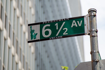
Walk Ketchum pedestrian program signage on streetlight poles, Idaho
So simple. Any place can do this.
Labels: bicycle and pedestrian planning, pedestrian planning, urban design/placemaking, visitor services, wayfinding signage systems
"A community’s physical form, rather than its land uses, is its most intrinsic and enduring characteristic." [Katz, EPA] This blog focuses on place and placemaking and all that makes it work--historic preservation, urban design, transportation, asset-based community development, arts & cultural development, commercial district revitalization, tourism & destination development, and quality of life advocacy--along with doses of civic engagement and good governance watchdogging.
So simple. Any place can do this.
Labels: bicycle and pedestrian planning, pedestrian planning, urban design/placemaking, visitor services, wayfinding signage systems
I have been so busy with other projects with hard and crunch deadlines, so I haven't had the time to write more about May's two big events, National Bicycle Month and National Historic Preservation Month. I should have some time next week to catch up and finish some partially written entries on the two topics.
This wayfinding sign for the Pioneer Historic Byway and visitor services in Soda Springs, Idaho, list public restrooms as a "destination."On Friday, in "Man peeing in hiding because there are no restrooms," I mentioned how a half mile up from where this guy stopped to pee, is a new public restroom at the Glendale Regional Park.
But why would he know that? There is no wayfinding signage on the bike lane or sidewalk abutting the park that points people to the restroom.
I also pointed out that the Jordan River Parkway signs at the 1700 South entrances, don't list nearby restrooms.
It's understandable for the new park, because Jordan River Commission hasn't updated signage for awhile and the Park just opened its first phase.
But across the street is "the old" Glendale Park and it has restrooms too, and the Parkway signage didn't acknowledge that restroom either, and it's been there for many years.
I suggested that how the Iowa State Department of Transportation's Bicycle Map uses a standard set of icons related to services for bicyclists could also be ported/adapted/adopted for bicycle route signage as well.
Something like this. Hey, I'm not a graphic designer. It could also somehow include the distance and direction to reach these services, just like the signs on the highway do.
Labels: bicycle and pedestrian planning, parks and recreation planning, visitor services, wayfinding signage systems
This man is stopping to pee in the trees on Jordan River Parkway at 1700 South in Salt Lake City. This is a vote for those Throne restrooms.The funny thing is with the new restrooms at Glendale Regional Park, no more than one mile behind him, he could have peed there.
But unless you know the park, which is brand new and in fact parts are still under construction, you wouldn't know because there isn't pedestrian or bicycle wayfinding signage on 1700 South that lists restrooms.
It makes me realize more than ever we need to add restroom proximity to wayfinding signage.
There is wayfinding signage on the Jordan River Parkway--although it's often out of date as here it points to "The Waterpark" as a destination and that's now the Glendale Regional Park. It could highlight the restroom too. It can be words like on the sign below, or the pictograms used in highway wayfinding signage systems.
But there isn't signage like that on bike routes. But it would be easy to do by adding it to the bottom of a sign, reserving the bottom section of the sign for "services." I'm pretty sure I thought about that when writing about "Making Cycling Irresistible" but it's been almost 20 years.
The Throne automated restroom could be perfect for other spots on the trail.I don't love their design which could feel discordant in a nature setting. But maybe just having a nature focused mural on three sides would make it fit better.
They are good because they're small and they don't need expensive connections to the water and sewage networks. They have that self contained through tanks, albeit they have to be emptied and refilled regularly.
Labels: bicycle and pedestrian planning, parks and recreation planning, parks and trails, public restrooms, wayfinding signage systems
Later he grew a huge beard but this is how I remember him.Open-casket visitation Sunday, August 3, 3pm (service begins 4pm) at Colvin House, 5940 N. Sheridan Rd., Chicago, IL 60660. Reception 5-7pm. Parking is limited. Guests are encouraged to take public transportation or rideshare.
In the early 2000s when blogs were the supreme social media (having long since been superseded by other media like Twitter/X, Instagram, TikTok, etc.), there was a small blogging community in DC devoted to the city and its urban issues and that's how I met him.
As part of my activism then I used to lead walking tours of "Florida" Market (now renamed Union Market, which was the original name, also see "Revitalization of the wholesale food Union Market in DC to a consumer focus," [2025]) to increase awareness and to ford off the attempt at urban renewal-ing a cool food business district, mostly oriented to wholesale customers, but a number of businesses also sold to the consumer.
I was also interested in the visitor/tourist/guest experience, these days the profession is often oriented to computers using the shorthand of UX--user experience. But the principles last.
In the tours besides going to businesses that sold to retail customers, we talked about missing amenities, like directories, trash cans, etc., which were used as reasons for urban renewal. My response was, yes it's dirty, why doesn't the city have trash cans? Yes, it's hard to find things, why isn't there a directory? Etc.
I knew Christopher as a "graphic" designer, but he was also into museum exhibiting and urban design, and he offered to help develop a "proof of concept" in wayfinding signage for the market.
The city already had a wayfinding system, but I discerned gaps, and the concept of a district area directory map was one. I also thought the "Discover DC" headers were more oriented to tourists, rather than both residents and tourists, so we developed a "Discover DC" concept as well.
The city sign. Maybe it's merely a quibble, but I liked the idea of "exploring" being open to all, not the implication of "discover" being you had to be an outsider to find something, ignoring the fact that these are existing places known to many.I had been aware of the concept of "design thinking" before this project, but he and I talked about it and related issues to design. These blog anniversary pieces draw a lot on design thinking, business process redesign, design method, and systems thinking. This was in 2008.
(I started blogging in 2005, and these anniversary pieces draw a lot on design thinking, business process redesign, design method, and systems thinking.
-- "20th anniversary of the blog| Urban revitalization systems thinking's greatest hits: Part one -- (in)FAQ and my influences,"
-- "20th anniversary of the blog| Urban revitalization systems thinking's greatest hits: Part two -- not transportation
-- "20th anniversary of the blog| Urban revitalization systems thinking's greatest hits: Part three -- transportation"
In my writings, I prefer the application of design thinking to the typical urban planning process of constrained scopes, because that allows for an iterative process that can explore and incorporate new ideas, rather than be limited to the client's defined and usually constrained scope.
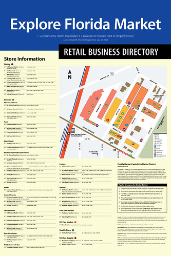
-- "Florida Market proof of concept wayfinding signage and the need for a wayfinding conference," 2009
-- Explore Florida Market (history)
-- Florida Market Map and Directory
I came up with the idea of using the local transit system's iconography rather than weak lines and or the weird looking industry-standard rail transit icon. We extended this to mapping bus routes using the WMATA graphic design as well, although it's not as pathbreaking.
FWIW, I still haven't come across a similar use of integrating local transit map graphic design into other map products.
There is tons of writing and display of great transit map design, but not about incorporating some of that design into different kinds of maps.
The design method, graphic design, and design thinking offer a lot to making better government services like parks, libraries, schools, forms, etc.
-- "City branding versus identity | Branding versus Urban Strategy," 2019
-- "All the talk of e-government, digital government, and open source government is really about employing the design method," 2012
-- "PL #7: Using the Purple Line to rebrand Montgomery and Prince George's Counties as Design Forward," 2017
-- "World Usability Day, Thursday November 9th and urban planning," 2017
-- "Branding's (NOT) all you need for transit," 2018
-- "Illustration of government and design thinking: Boston City Hall to Go truck," 2013<
"Best practice bicycle planning for suburban settings using the "action planning" method," 2013,
Thank you Christopher.
============
Over the past week, I came across some design thinking publications, downloadable, from the UK Design Council.
-- The Design Economy: Environmental and Social Value of Design
-- Design Economy: People, Places and Economic Value,
-- Design for Neighbourhoods: A design agenda for the new government
-- Future of Motorway Service Areas (interesting speculation about electric cars)
-- Public Design Beyond Central Government Key Insights and Recommendations
-- "Five components of social design: A unified framework to support research and practice," Design Journal
Labels: design method, graphic design, information design, obituary, wayfinding signage systems
I thought the Esso road map from London was the only "gas station" map that included a subway map.
It turns out, NYC too. And, I'm going to have to do further research because it's possible that the NYC map with subway information was published earlier than the Esso London map.
Both produced by Esso's map division, General Drafting Co.
That division also produced subway exclusive maps for banks and other organizations in New York City.
It's possible that a gas station map includes rail transit information for Chicago, Paris or Montreal, although the Montreal system didn't open until 1966. I'll research that every so often.
-- "When Maps Reflected Romance of the Road," New York Times
Labels: tourism marketing, transit marketing, wayfinding signage systems
That's pretty creative. And something that should be done for every center city wayfinding system.
A number of years ago, I wrote an article on culture-based revitalization in Thessaloniki for the Europe in Baltimore program sponsored by the EU National Institutes of Culture Washington Chapter.
-- "Thessaloniki: Regeneration as an ongoing process"
And in the Bangkok Metro system, they have painted similar information on stairway risers.
Labels: health and wellness planning, parks planning, pedestrian planning, urban design/placemaking, wayfinding signage systems
Yalecrest is a neighborhood historic district in Salt Lake City. The State oegislature makes it exceedingly difficult to create locally designated historic districts with controls over development.
A National Register historic district provides protections only against federal undertakings--urban renewal, a freeway, etc.--so it provides little in the way of substantive protection against incursions, demolition, inappropriate rebuilds, etc.
And those are the problems faced by Yalecrest and other neighborhoods of historically eligible building stock in Salt Lake City.
K.E.E.P Yalecrest--Keep Educating and Encouraging the Preservation of Yalecrest--is the organization focused on historic preservation matters in the neighborhood.
I write often about wayfinding and cultural interpretation signage systems. As well as neighborhood/commercial district branding and identity systems ("Basic planning building blocks for urban commercial district revitalization programs that most cities haven't packaged: Part 2 | A neighborhood identity and marketing toolkit (kit of parts)").
And I have written about historic district signage ("Reassessing historic preservation on account of it being National Historic Preservation Month," 2010).
As the Internet--URLs, and QR codes have been widespread, there is no excuse for erecting a sign in 2022 and not having a URL or QR code link, ideally to a website or app with more information about the community, a webpage on the historic district nomination (context statement), link to the sponsoring organization, meeting and events page, etc.
Labels: civic engagement, cultural planning, historic preservation, protest and advocacy, public history, urban design/placemaking, urban planning, wayfinding signage systems
The London Underground is noteworthy in how it's created a map with a list of walking distances between stations, in part to communicate that in some cases, rather than transfer between lines, it's faster to get out and walk. They have maps for specific lines, as well as for all the stations in Central London.
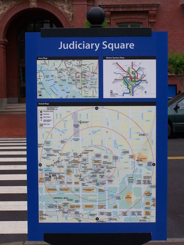
Many transit wayfinding maps are typically organized around presenting a walkshed at 1/4, 1/2, and 3/4 mile distances.
Separately, there are walking oriented wayfinding systems like Legible London (which actually is based on the system first created in Bath, England). Although London uses the same wayfinding system for transit, walking, and biking.
There are "guerilla wayfinding" systems encouraged as an element of tactical urbanism, to call attention to walk distances wrt locally-available amenities.
But I haven't seen bus stops and shelters conceptualized as an element of the walking network, or at least incorporating walking information as well as transit information in one place. But the Cache Valley Transit District has done that at some--not all--bus stops in Downtown Logan.
It orients riders and tells them in which direction are the major destinations and how long it will take them to get there.
This would be an easy addition to bus stop signs and shelters. And it's a small transit system with a national best practice.
-- "Arlington County's bus shelters and a public realm framework of quality," 2013
Labels: bicycle and pedestrian planning, transit wayfinding, urban design/placemaking, walking, wayfinding signage systems
The movie, "The Joker" has brought attention to a public stairway in the Bronx ("'Joker' Stairs Become a Bronx Tourist Draw. Hope You're in Shape," New York Times).
One of the images in the Wired New York thread, from a DNAInfo article, is of a fabulous horizontal staircase connecting Teller and Clay Avenues at 168th Street.

Biking. The same is true for biking in terms of deploying special infrastructure to make connections in areas with severe access challenges like rivers, highways, and topography.Local and regional leaders had pushed Maryland to include an originally promised bike and pedestrian path as part of the bridge, but the MDTA board led by Transportation Secretary Pete Rahn voted against that proposal Thursday at a meeting in Baltimore.This is but one of many examples of the cost of political pandering to sustainable mobility, in particular biking, walking, and transit.
Under the selected bid, the path would have added $64 million to the cost.
The Hogan administration said that was too expensive after the administration cut toll rates on the bridge in 2015.
Labels: bicycle and pedestrian planning, civic assets, integrated public realm framework, sustainable mobility platform, urban design/placemaking, wayfinding signage systems
A few years ago, when I did an entry on wayfinding signage, a blog commenter mentioned the Society of Environmental Graphic Design and all the great resources they have.
Labels: signage, urban design/placemaking, wayfinding signage systems
In writing a piece that will publish tomorrow, I was looking for an image from Columbus. I couldn't find what I was looking for, but I did find a webpage on transportation options from Experience Columbus.
Labels: transit marketing, transit wayfinding, urban design/placemaking, visitor services, wayfinding signage systems
I am trying to reduce the amount of "unnecessary information" I have stuffed in boxes, so I am doing some "processing." Most of the articles I've clipped no longer seem that necessary. But I still come across some gems.

Labels: bicycle and pedestrian planning, urban design/placemaking, wayfinding signage systems

![Walk [Your City] style guerrilla street wayfinding signage produced by the SW DC Business Improvement District](https://live.staticflickr.com/4581/24421249988_4d5ba39a9d.jpg)
Labels: business process redesign, cartography and mapping, civic architecture, design method, graphic design, transportation infrastructure, urban design/placemaking, wayfinding signage systems
-- Urban Wayfinding Planning and Implementation Manual, published by the Sign Research Foundation which it turns out has a resource library with more than 4,600 items, and the International Signage Association
Labels: transportation planning, urban design/placemaking, wayfinding signage systems
Designed by FitzpatrickWoolmer on the Brecon Beacons Canal for the Canal And River Trust.Labels: parks planning, street furniture, urban design/placemaking, wayfinding signage systems
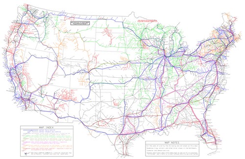
US intercity bus service map produced by Michael Buiting.


Labels: bus, cartography and mapping, customer service, GIS, intercity transit, transit wayfinding, transportation planning, travel planning/tourism, wayfinding signage systems
I wrote last week about how the various separate BRT planning efforts around the metropolitan area are an example of a lack of metropolitan-scaled transit planning. The maps displayed in DC bus shelters are another example.
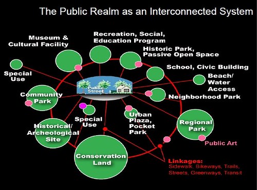
Transit shelters as a marketing touchpoint. From "Arlington County's bus shelters and a public realm framework of quality":
Proof of concept business district wayfinding signage. Many years ago, Christopher Taylor Edwards and I created a conceptual business district map that among other elements, showed transit routes using the same graphic design treatment WMATA uses on their own map products.
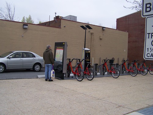
Maps at bike sharing stations end up being used by pedestrians as well.
Labels: public realm framework, transit marketing, transit wayfinding, transportation planning, urban design/placemaking, wayfinding signage systems