Rome 2 Rio is an incredible website integrating all forms of mobility to get from one place to another--globally!
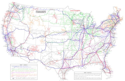
US intercity bus service map produced by Michael Buiting.

In a back and forth set of comments spurred by Larry Littlefield's post which in passing discussed inter city bus service in New York State, we were talking about bus route network maps.
In the old days, railroads and intercity bus systems like Greyhound and Trailways published complete maps of their route systems.
Now it's very hard to find such maps. Michael Buiting produced one on his own. See the past blog entry, "Inter-city bus services are typically a gap in transportation planning." The entry references some academic research and other writings on the subject.
Larry said you can't find these kinds of maps for Coach USA/Megabus services at the scale of a state or region, let alone a complete network map.
Yes you can plug in stuff online, but you can't get a sense of the full system and all its possibilities, counter to "the old days." (Similarly, regularly published complete guides for railroad passenger and airline service provided this function, showing all available services.)
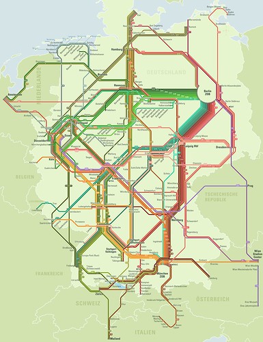
Mein Fernbus/Flixbus, Germany. I mentioned that when I was in Germany, I saw a variety of intercity bus companies in service, near train stations in Essen and Hamburg. (In Hamburg the Intercity bus terminal, ZOB, is in close proximity to the train station.)
Because some of the Mein Fernbuses I saw had rear-mounted bike racks, I looked into their services more--note they have since merged into Flixbus.
They publish route maps comparable to the maps once published by Greyhound and Trailways, even differentiating between their day and night networks, but I like best an earlier version of their night map (below).

It turns out their website and computing systems are developed by stfalcon, a Ukrainian firm.
Were I in charge of finding a programming team to set this up for a transit system, they'd be one of the contenders, clearly. This webpage discusses the work stfalcon has done for Mein Fernbus.
Rome2Rio Global Travel Planning website. While tracking done some URLs, I came across Rome2Rio, a travel search and ticketing website that has managed to integrate airplanes, trains, intercity bus, ferry, local transit services, and taxis into one system.
It's pretty remarkable.
US and Canadian inter city bus service map, based on route information collected by Rome2Rio.
But they don't have a function where you can produce and print out master route systems maps as a website user, although on occasion they have blogged about doing it themselves, such as when they added US and Canadian inter city bus coverage to their system.
Wanderu. Note I have mentioned/used Wanderu to do bus trip planning in the US, as they have a master set of information. But Rome2Rio takes integration and mode coverage to a whole new level.
Labels: bus, cartography and mapping, customer service, GIS, intercity transit, transit wayfinding, transportation planning, travel planning/tourism, wayfinding signage systems


2 Comments:
Have used Wanderu. Checked Rome2Rio, and they did not bring up the Greyhound route from my podunk city to NYC. That's a big omission. The problem with these sites is you never quite know what information to trust, although than can at least help you find routes & carriers to check directly. A printed map is nice in theory, but these days I always say the problem with anything printed is it becomes obsolete before the ink dries. The Buiting map linked, although a few years old, had omissions as well (as of the date it was made). The explosion of various intercity bus services means that routes can come and go quickly. This is a confusing, but more a feature than a bug.
Good day. This information is very interesting. Also I would like to recommend to read an article about Taxi App Development: https://rexsoftinc.com/taxi-app-development
Post a Comment
<< Home