Basic planning building blocks for urban commercial district revitalization programs that most cities haven't packaged: Part 2 | A neighborhood identity and marketing toolkit (kit of parts)
========
This entry, which has tons of photos, blew up my blogger. Well, it didn't blow it up, but it exceeded the display capacity so previous entries weren't showing up on the page. It led me to learn about the "Jump Break" command, where only a small portion of the entry is displayed, and the reader has to click for more.
I haven't wanted to do that in the past, because I thought "people wouldn't read the whole entry." But that probably was happening anyway.
I have inserted the Jump Break command here, so to get to the meat of the entry, you'll have to choose to go forward.
I hope you do. Lots of great images.
========
This is a follow on entry to "Basic planning building blocks for urban commercial district revitalization programs that most cities haven't packaged: Part 1 | The first six."
The seventh building block is a toolkit of neighborhood identification and marketing tools, along with a basic funding allocation to bring it about and maintain the program.
-- "Basic planning building blocks for urban commercial district revitalization programs that most cities haven't packaged: Part 2 | A neighborhood identity and marketing toolkit (kit of parts)"
-- "Basic planning building blocks for urban commercial district revitalization programs that most cities haven't packaged: Part 3 | The overarching approach, destination development/branding and identity, layering and daypart planning"
-- "Basic planning building blocks for "community" revitalization programs that most cities haven't packaged: Part 4 | Place evaluation tools"
Creating a set of neighborhood business district identification and marketing tools for implementation in commercial district revitalization programs.
1. Gateway signage.
2. Directory/place identification signage.
3. Include directory/place/events identification signage at transit stations and in bus shelters.
4. Include directory/place/events identification signage at public buildings in the area such as libraries, schools, parks, human services offices, etc.
5. Intra-district wayfinding signage.
6. Creation of mobility wayfinding systems for transit, parking, and biking in analog and digital forms.
7. Create a thumbnail lighting master plan.
8. Streetlight/utility pole banners, signage, and plantings.
9. Street furniture improvements.
10. Urban design improvements including treebox plantings and maintenance.
11. Making ordinary street signs extraordinary.
12. Integrate public art in the public space.
13. Printed marketing materials (not just digital).
14. Store and district based information distribution.
15. Create an annual calendar of programs and events, and distribute and promote it.
For years I've been meaning to do a write up on what a more complete approach to neighborhood identity elements should look like in the context of a commercial district revitalization initiative.
This comes out of visiting other places, seeing images from other places, and then thinking about what might be all the elements that could be part of an integrated program. Especially because there is not such a complete "package" that is implemented in DC. (To be fair, this is a problem generally.)
We are all destination managers now. It's also rooted in one of my earliest blog entries, from 2005, "Town City Branding or 'We are all destination managers now'," where I make the point that when we make places great for "us" residents, they are also attractive to visitors, and since to be successful, most businesses need more customers than normally live in our district, that's helpful for everyone.
This particular element, destination development/branding and identity planning is discussed in way more detail in the third article in this series.
BIDs have money, most Main Street programs don't. Compared to Main Streets, BIDs have a lot of funding, so they can put money into these treatments (although most don't have a complete program either). Since commercial districts need these elements whether or not they are BIDs, such funding should be provided.
This too can be an element of what I think of as differentiated approaches to supporting commercial districts. In DC, there are two approaches, a business improvement district or a Main Street program, and that isn't nuanced enough. To have a Main Street program you need an engaged community and organizational capacity. Many of the places where DC has created or is creating MS programs lack enough depth and breadth.
But other districts may just need marketing support, which would be this kind of program, and a coordinating mechanism.
City-wide identity and wayfinding signage system. The ur models come from Britain. It turns out that the very comprehensive system created in Bath, England more than 10 years ago is the model for systems later deployed in London and New York City.
I have written more extensively about this, with links, and wayfinding signage systems in this post from 2017, "World Usability Day and urban planning."
Some places have city wide systems that incorporate neighborhoods, like Los Angeles, Baltimore, and Arlington County. But they don't tend to be updated regularly and they don't necessarily have all of the elements at the neighborhood business district scale that I recommend below.

Sub-city/intra-district wayfinding supports commercial district revitalization. Such systems should have a "rung on the ladder" for neighborhood commercial districts. DC doesn't have this, although there is a pedestrian and motorist signage program, alongside a heritage trail program.
That's why in 2009, working with Christopher Taylor Edwards, we created a "proof of concept" set of two signs for the Florida Market area--now called Union Market, to show how intra-district directory signage could be incorporated into such a program. Note that back then I was giving tours of the market district and the way people "consumed" the place on the tours influenced my thinking about what we needed to do.
One side was a directory and the other side is for historical interpretation.

The city does a version of this here and there outside Metro stations, called Discover DC, but it isn't systematic about it. It's actually the model we used to show what can be done in neighborhood business districts, paired with a more focused map and an actual business directory.
-- Discover DC Map sign, Gallery Place
-- Discover DC sign, History side
We used the word "Explore" instead of "Discover" so that it would better embrace residents as well as tourists ("Florida Market proof of concept wayfinding signage and the need for a wayfinding conference"). That was Christopher's idea.
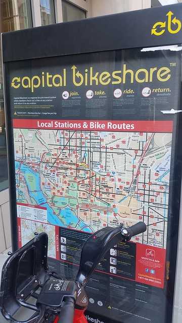
Bike sharing kiosk maps are DC's default wayfinding system. Because DC doesn't have a map signage system, the map signs on bicycle sharing stations are the closest that come to a city wide mapping system..
I've written about the Alexandria Virginia wayfinding system, which is the best in the DC area. At the scale of the block, they have a four sided sign that has two map signs, one for each direction, a sign on a particular element of area history, and the fourth is a historic photo.
The Legible London system includes neighborhood wayfinding and mapping on bicycle sharing kiosks is integrated into the system. While the mapping system for the bus and Underground is still somewhat separated, it is being integrated into the overarching program.
Building a basic set of neighborhood business district identity and marketing tools
1. Gateway signage. I can't see DC agreeing to the kind of gateway signage that San Diego encourages for each of the city's districts. The previous entry showed the North Park sign, but there are similar signs across the city in other commercial districts, like this one for Little Italy.

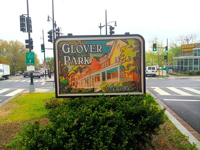
The closest I've seen to this in DC is a neighborhood gateway sign in Glover Park.
Such signage should utilize walls and bridge abutments too.

Seattle


Try not to be boring.

Sign for Venice California strung across the intersection of Windward and Pacific Avenues. Melissa Lyttle, New York Times.
2. Directory/place/events identification signage. The Explore signs that Christopher and I came up with are a good example for what can be done. We included (1) directory information and (2) historic/cultural interpretation information. Besides directory and cultural information, a complete signage program should include (3) events listings and (4) general notices.

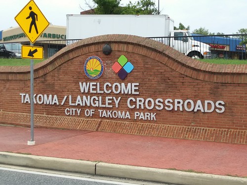
Most cities focus on directory signage, like Takoma Park, Maryland (which uses the same signage system in different parts of the city), although the back side of this sign is for community notices, including events, but it is more haphazard. TP is smart in that the directory section is printout out as a "sticker" so it can be easily updated without replacing a whole side of sign.

What I recommend is a three- or four-sided kiosk. One side for directory, one side for historical information, the third a directory of events, and the fourth for various announcements. And not just one kiosk, multiple, depending on the characteristics of the particular districts.

Liverpool's signage system focuses on the multi-block pedestrian district emanating from the city's train station, but it includes other key points of interest abutting this area, like the Baltic Triangle which has become an entertainment district interspersed with industrial buildings or the Liverpool Cathedral..
You can be creative. This is both a gateway and place identification sign. It's public art too.

Roosevelt Row Arts District, Phoenix
Where they exist, I would incorporate traffic signal boxes into the system. (Although I appreciate that some people use them for protest flyers.) Some places use them for public art including historical interpretation, others for traffic safety messaging. Hamburg uses them for events information and identity.

Calgary, Alberta.
![RARE OUL TIMES BY EMMALENE BLAKE [PAINT-A-BOX STREET ON HIGH STREET IN DUBLIN 8]-145799](https://live.staticflickr.com/4881/32147295398_8ac4c3c7a5_w.jpg)
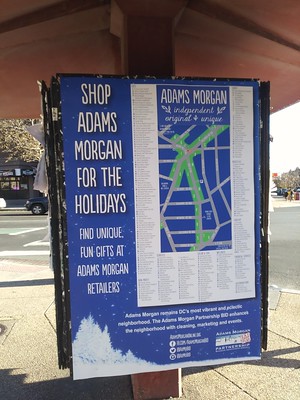
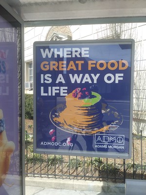
Adams Morgan BID has recently updated their branding program, although they are better at the identity element and lag on the directory side.
Using the thematic approach to a community's history having multiple dimensions, Petersburg, Virginia has a kiosk signboard outlining the city's history at the city visitor center.

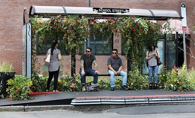
3. Include directory/place/events identification signage at transit stations and in bus shelters. Transit stations and stops can be key marketing touchpoints, not just for transit but for a commercial district too. Sadly, the Metrorail system doesn't allow for inclusion of commercial district revitalization district maps in subway stations. That should be addressed.

Discover Long Branch area directory posted in a bus shelter.
Note that the quality of bus shelters and transit stations is an indicator of how much the community values transit. Shelters are managed by the city/the transit agency, and local commercial districts have little say in their design. But the facilities need to be included in commercial district planning to ensure that they contribute positively to community identity (also see "Transit, stations, and placemaking: stations as entrypoints into neighborhoods," 2013).
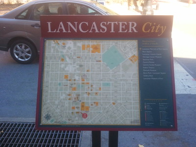
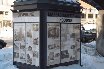
Because bus shelters are operated by the jurisdictions, not WMATA, they can have localized information. Some BIDs in DC do this. (But mostly I don't like how they tend to do it.) Most Main Street programs don't. The RidePhiladelphia program of the Center City BID has transit history signage. Lancaster, PA and Boston too, along the Silver Line.

Boston
Bus shelter in the Sugarhouse district of Salt Lake City. Not the prettiest, but it tells you where you are.

Alexandria has installed primary place identification signage at their Waterfront and the King Street Metrorail Station, which is complemented by block by block signage.


4. Include directory/place identification signage at public buildings in the area such as libraries, schools, parks, human services offices, etc. (Ideally, a city-wide system of identification signage for public buildings would be created, which could complement this program. Alexandria's wayfinding signage system, while not completely integrated, extends to parks and trails.)
5. Intra-district wayfinding signage. If your district is only one block then you only need one block's worth of signage. Bigger than that, you need more. I like the Alexandria system, but it is more directional, and focused on major destinations, not so much on showing what's on a particular block.


34th Street Partnership, NYC.
6. Creation of mobility wayfinding systems for transit, parking, and biking in analog and digital forms. This is about providing people with the information they need to reduce the potentially negative impacts of their mobility choices. For example, with parking, the issue isn't so much that "there isn't parking" but that it's not coordinated and marketed. Messaging for transit and biking promotes coming to your district in more sustainable ways. While people know when your district is served by a major transit station, how to get there by bus is probably less well understood. Include this information in brochures, on websites, etc.

Hyattsville has produced this as a poster and a street sign.

Digital screen displaying transit information.

Digital sign showing available parking spaces.

7. Create a thumbnail lighting master plan. Innovative cities are developing lighting master plans and given that often we aim to create districts that are active into the late evening, we need to be more conscious of and address night-time lighting for neighborhoods, commercial districts, schools, and transit stations and stops.
-- "Night-time safety: rethinking lighting in the context of a walking community," 2014
-- "Lighting as an element of urban design and community identity: Cleveland chandelier + Chicago lighting design framework plan design competition," 2014
-- Vision and Roadmap Urban Lighting: Eindhoven 2030
-- Bath City Centre Lighting Strategy
-- LUCI | Lighting Urban Community International
The Eindhoven Lighting Master Plan identifies six categories of light, comprising the elements of a complete plan:
- urban lighting (streets, public areas)
- buildings and objects (architectural lighting)
- art (indoor and outdoor)
- events and festivals
- information
- advertising.
Business signage crosses across multiple light categories and can be a kind of public art.

F Street, Downtown Washington, 1950

Architectural lighting of the Courthouse, Downtown Sulphur Springs, Texas

Pedestrian focused street lights on a taller pole, 2100 South, Salt Lake City,


Architectural lighting of an underpass near the transit station in Lynn, Massachusetts by the Beyond Walls project.
Some cities, such as Cleveland, have programs to assist churches in lighting their steeples as a way to add visual attraction to their communities.

First Reformed Church, United Church of Christ, Sunbury, Pennsylvania. Photo: Justin Engle, Daily Item.
8. Streetlight/utility pole banners, signage, and plantings. Utility poles are ubiquitous in most commercial districts and are a potential marketing touchpoint. Banners mark and market a commercial district. Banner programs can be changed seasonally, but require a regular budget. They need to be replaced when faded or torn, etc. Metal signage lasts a lot longer but isn't changed out. Holiday lights and other treatments are common. Some district hang planters but this requires daily maintenance.

Some organizations waste the opportunities that banners can provide.
The Adams Avenue Main Street program in San Diego has an annual banner program, where artists get a small honorarium to create individual banners. Some programs set up banners to have individual businesses in the district listed on the bottom, as sponsors.
Adams Morgan has incorporated lighted figurative decorations into their "banner" program. Normally, this style of decoration is limited to holiday lighting.


Metal banner on the left, wayfinding sign on the right.

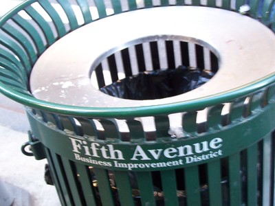
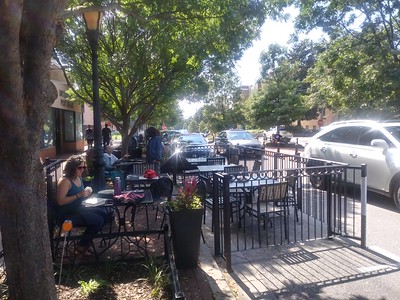
9. Street furniture improvements. This includes trash cans (many BIDs have shifted to smaller cans which I think is a mistake), benches, movable tables and chairs, game equipment like a metal ping pong table, bicycle racks, bicycle air pumps and repair stands (too often omitted), treebox protectors, planters, clocks, bus shelters, the above-mentioned kiosks, etc.
This can be tricky because depending on the stage where a commercial district is at, seating can promote nuisance behavior. Generally, public seating is recommended for later stages and in well surveilled locations.
-- Street Furniture and Amenities: Designing the User-Oriented Urban Landscape
-- Minneapolis Coordinated Street Furniture Program Guidelines

The 9th and 9th district in Salt Lake City includes gateway signage at multiple intersections, trash cans, bike racks, a bicycle sharing station, and specially designed street light fixtures.

People brought their own tablecloth to use at a public table, 4th Street SW

Some companies are offering very creative pieces, like the Flower Chair from Street Furniture (Australia).

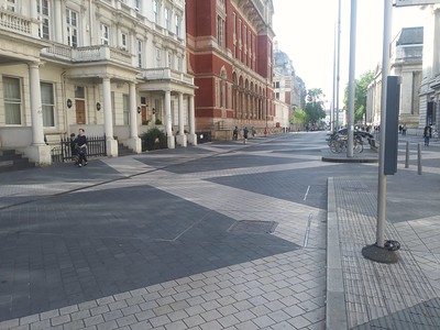
10. Urban design improvements including treebox plantings and maintenance. These include the materials and design of the street and sidewalks, crossing treatments, parklets, playgrounds, etc. In the DC area, only Takoma Park, Maryland has legalized restaurant patios in place of parking spaces.
-- "The soft side of commercial district competition (2006), focuses on the appearance of a commercial district
I argue that areas around commercial districts, transit stations, schools, libraries, and parks should be paved in materials that slow motor vehicle speeds.
-- "Pedestrian fatalities and street redesign," 2019
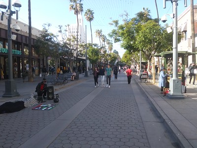
3rd Street in Santa Monica has been pedestrianized and the street and sidewalk materials upgraded.
Exhibition Road, London.
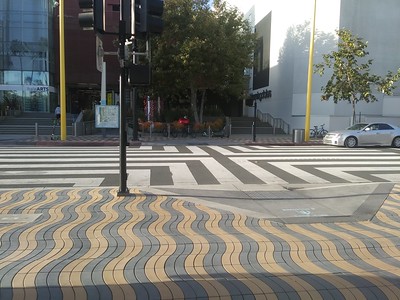
Colorado Avenue, Santa Monica includes a special street/intersection treatment near the Expo Line transit station.

Special pavers on 7th Street SE at Eastern Market. The street is pedestrianized during the day on weekends.

A bicycle and pedestrian crossing on the Indianapolis Cultural Trail.
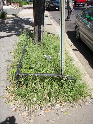
Unkempt treebox. I don't understand why many independent retailers don't take care of abutting treeboxes, which reflect both on the individual business and the commercial district as a whole.
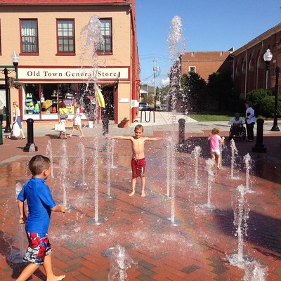
Visiting this district with a friend, whose children were away, he commented that a splash fountain wouldn't be enough to keep his kids interested.

Rock playground, Pearl Street Pedestrian Mall, Boulder, Colorado. In Essen Germany, I was surprised to see playground equipment interspersed throughout the pedestrian district. And it was super high quality equipment, made of stainless steel.

Adult swing set, Montreal.
11. Making ordinary street signs extraordinary. Some cities have programs where typical street signs are augmented when the area is a special district such as a historic district. Toronto has an extensive program. The 34th Street Partnership pioneered lighted street signs, which are particular useful at night.


Petersburg, Virginia color codes street signs by historic district.


12. Integrate public art into the public space. Sculpture, murals, artistic signage, storefront display programs, etc. can be incorporated. Murals tend to be the most common.
It can (should) be a combination of temporary and permanent installations. Temporary placements draw attention. For example, the NoMA BID mural program has spaces that are painted anew each year, working with the international Pow Wow! organization.
-- "THE SIGNIFICANCE OF PUBLIC ART TO ITS SPACE: PEOPLE’S SPACES, PEOPLE’S CHOICES," New Geography
-- Public Art Archive, image database of public art projects
-- "Art in Public Places" photo essay, Boston Globe
-- Public Art Review journal
Sioux Falls, South Dakota sponsors a SculptureWalk each year. The Georgetown BID in DC sponsors an annual lighting sculpture program called "Georgetown Glow" in December and January.
Some transit agencies like Tri-Met in Portland, Oregon, the Stockholm subway, and the New York subway and railroad system, are known for incorporating high quality public art into their stations and sites. Tri-Met has commissioned and installed controversial pieces that challenge convention and history, which is atypical for a government agency. Although such works are at a scale significantly beyond the resources of the typical commercial district revitalization program. But Philadelphia's program of artistic bus shelters in their Downtown is much more realizable.

Expo Gates by Valerie Otani at the Expo Station on the Tri-Met Yellow Line references dog tags worn by Japanese-American internees during World War II, when the site was used as an internee staging center. Reproductions of newspaper front pages of the time, which were virulently racist, are placed in the base of the poles.
Distinctive business signage is a form of public art and community identification also.

Tochterman Bait and Tackle Shop, Baltimore

Saint Catherine Street, Montreal, summer street closure and public art and festival program (Aires Libre).


Everett, Massachusetts Bus shelter adorned with flowers by local artist Krissy Price. Boston Globe photo.
The Crystal City commercial district in Arlington Virginia is an aesthetically boring business district, but more recently, they've been creative in adding "color" and creativity in a variety of ways, including mural like additions to what would normally be a mundane parking structure entrance.


A mural was incorporated into this otherwise very dull entry sign at a shopping center on New Hampshire Avenue in Takoma Park, Maryland.

Steve-Powers_ESPO_LoveLetter-Syracuse.
Blank walls are an opportunity.

Greetings from Georgetown (Texas) mural at Guss Drug.

Greenwich Village community map mural.
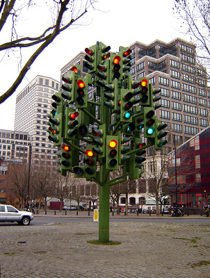
Traffic Light Tree sculpture, Isle of Dogs, Tower Hamlets by Pierre Vivant.
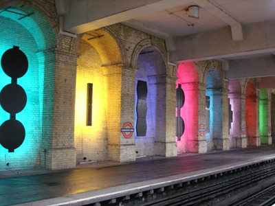
Gloucester Road Tube Station, London, architectural lighting
Freeway abutments and over- and under-passes can be opportunities for public art also. While I don't do a lot of freeway driving, it appears that Las Vegas has the most systematic approach to this ("Screens, artwork help decorate highways in Las Vegas," Las Vegas Review Journal).

Corktown freeway underpass pylon murals, Toronto. Toronto Star photo.

Las Vegas
13. Printed marketing materials (not just digital). Directories and brochures of various types, which can be distributed at visitor centers and around the commercial district, are important.
Too many organizations believe that social media and online websites and apps suffice. But people consume information in many different ways, both before visiting and during.
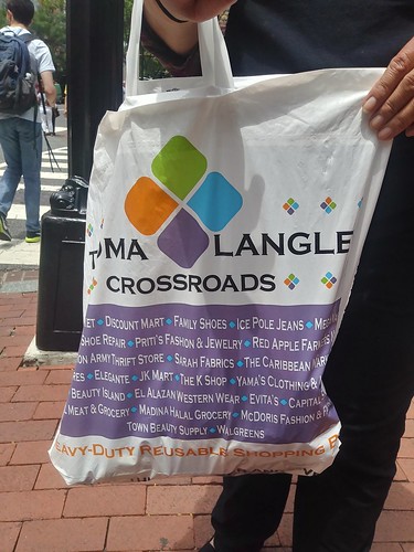
Don't forget items like shopping bags. Some commercial district revitalization groups produce brochures with an annual calendar of events. Downtown Winchester even publishes an events tabloid during the summer.

From the standpoint of "maximarketing" or what is now called "omnichannel marketing," printed items shouldn't be ignored because they are an essential element of a complete marketing program.
14. Store and district based information distribution.. Most commercial districts don't do this very well. Downtown Alexandria in Virginia is an exception, with small brochure racks placed in most stores with directory, tourist, and transit information (although I don't have a good photo).
Larger districts, usually business improvement districts or areas supported by the local tourism promotion organization also have created outdoor brochure kiosks, usually just for peak visitation periods.
One problem with transit agencies is that they tend to only want to distribute transit information and not visitor information. (And federal agencies, at least in DC, refuse to distribute non federal information. This is an especially big problem with the National Park Service and the Smithsonian, but also the National Arboretum.)

Tempe, Arizona transit information rack

15. Create an annual calendar of programs and events, and distribute and promote it. As mentioned above, some visitor and commercial district organizations publish a coordinated calendar of events. It is amazing to me that most districts in Washington, DC neither (1) coordinate events across organizations nor (2) publish a combined calendar.
Instead of printed items, many groups rely solely on digital calendars as part of their websites and apps. But some groups don't maintain them very well. This is an area where local governments can step up and serve a coordinating and technical role.

Winchester Virginia has a number of examples. A visitor brochure, the monthly events tabloid in the summer, and monthly posters.
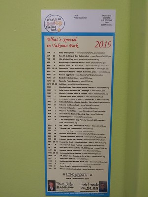
In Takoma Park, Maryland, such a calendar is published and distributed by a local realtor. If I remember correctly, this was posted in a local bike shop.
And the Takoma Main Street program posts banners listing the events of the month and season at key locations in their central business district.


Directory banner for a short term event.
Labels: commercial district revitalization planning, special events and programming, urban design/placemaking, visitor services
posted by Richard Layman @ 1:38 AM&Permanent Link
![]()
![]()


2 Comments:
Church in Philadelphia downtown is launching a capital campaign to fix its steeple.
https://www.inquirer.com/life/arch-street-united-methodist-church-steeple-repair-philadelphia-fundraising-20211116.html
The article mentions the National Fund for Sacred Places as providing an initial grant.
https://fundforsacredplaces.org/
https://www.chicagobusiness.com/crains-forum-neighborhood-vitality/englewood-neighborhood-proving-its-market-power-opinion
Englewood Branded, the neighborhood’s beloved lifestyle brand and community hub, hosts multiple large-scale events each year, including an extravagant Fall Festival with carnival rides and horses, and a Winterfest complete with an ice-skating rink.
Post a Comment
<< Home