Wanted: a metropolitan scale bikeways/trails program run by the Metropolitan Planning Organization
In transportation planning, "Metropolitan Planning Organizations" are tasked by various federal laws for coordinating transportation planning for all modes--primarily roads and public transit, but also biking and walking. Some MPOs have wide ranging responsibilities for other types of planning, including land use, parks, or water treatment, others less so. A handful of MPOs run transit systems.
In the Washington Metropolitan Area, the National Capital Region Transportation Policy Board of the Metropolitan Washington Council of Governments is the MPO, in Baltimore, its the Baltimore Metropolitan Council.
 While it happens the TPB has produced the 2015 Bicycle and Pedestrian Plan for the National Capital Region, I am not sure it rises to the level of a true metropolitan bikeways plan.
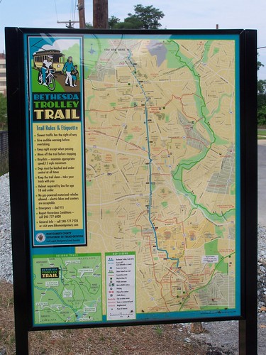
 The closest to a map of such a network is as an inset in the wayfinding signage for the Bethesda Trolley Trail in Montgomery County.
The Paved Trail Draft Plan for the National Park Service mentions that the Washington Area Bicyclist Association has proposed the creation of a "Regional Trail Coalition" to push forward the creation of a better interconnected bikeways system.
In any case, in my comments on the NPS plan, I stated that such a function shouldn't be voluntary, but required of all of the jurisdictions, that the NPS plan should state that the TPB should create a "Regional Trails Collaborative" and that the NPS would join.
While WABA should be commended for advocating for a metropolitan bikeways network (technically I define regional as two or more metropolitan areas, so that DC is a metropolitan area but DC-Baltimore is a region) it should be an official function of the bike and pedestrian program of the TPB. But WABA and other bicycle advocacy groups should be encouraged to participate.
However, while the TPB bike plan is ok, I'd argue it needs to be organized differently and should be more comprehensive and directive if the aim is to develop a planning framework that pushes forward the creation and extension of a robust bikeways network at the metropolitan scale..
The DC area does have some highly used trails that serve both transportation and recreation functions, including the Mount Vernon Trail--on NPS property, the Capital Crescent Trail, on various properties, including NPS and the State of Maryland and DC, and the Metropolitan Branch Trail in Montgomery County and DC--this trail will require more than 30 years to be finished, dating to when it was conceived by a local planner back in 1987, and others across Northern Virginia and Suburban Maryland.
Some trails are best practice, a number have exemplary bridges, some sections may have lighting, etc. One element that distinguishes biking in the DC area are bridge crossings across the Potomac River, including the 14th Street Bridge in DC, connecting to Arlington County Virginia, and the Wilson Bridge in Maryland connecting to Alexandria Virginia. There are special bridge crossings for pedestrians and bicyclists over freeways in Forest Glen and Rockville in Montgomery County.
Various trail projects in Maryland, Virginia and DC continue to extend the network, although these projects take many years to execute. A recent trail in the Potomac Yard district looks to be quite good, and Prince George's County is planning a path along their segment of the Metrorail blue line ("Comments on the Central Avenue Connector Trail concept").
More Metrorail stations are accessible by bike--in fact the Washington and Old Dominion Trail in Fairfax County connects to the new Silver Line, and WMATA has been very good about expanding bike parking in the last few years especially.
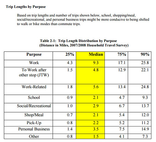
Commute trips. The TPB plan alerts us to some important findings. First, that 17% of commutes are under 5 miles, 21% are between 5 and 9 miles, and 17% are 10 to 14 miles.
Trips up to 9 miles--38% of the number of total commutes--comprise the best opportunity for capture by bike. Longer trips, including those from 10-14 miles, can be captured by bike, if augmented by the use of e-bikes ("(Still) tired of mis-understanding of the potential for e-bikes").
All trips. In terms of transportational trips capturable by bike, there are many opportunities as well, because many trips--more in the core of the metropolitan area--are under five miles. Note that while suburban trip tend to be much longer and less capturable by sustainable means, at the sub-county scale trips can be shifted from the car, as long as there is a bike-pedestrian-transit network. "Trunk line" bikeways can serve both longer and sub-city/sub-county trips.
That being said, there are plenty of problems and gaps in current bicycle planning practice across the jurisdictions in the Washington metropolitan area, and strong guidance from the MPO in the form of a metropolitan bike plan could help work through some of the contradictions, including:
- the justification of the need for a metropolitan bikeways network
- creation of a bikeway hierarchy (metropolitan/cross-jurisdiction, county/city, neighborhood/town center/district/sector)
- the tension between transportation and parks departments in the provision and management of path infrastructure used for both recreation and transportation
- connections between jurisdictions and to major activity centers
- lack of strong guidance on the need for wider path widths for highly used trails (e.g. the Shared-Use Path Level of Service Calculator: A User's Guide provides much stronger guidance than that from AASHTO, and the use of that calculation system could be mandated by the MPO)
- integrating NPS facilities into a bikeways network, local funds for maintaining NPS trails that are major transportational facilities
- integrated signage and wayfinding systems
- end-of-trip support facilities, including an outline of best practice facilities (often not from the US)
- guidance for bike parking in high density activity centers and for multiunit residential properties
- maintenance, including winter maintenance of trails
- trail security planning.
- supporting recreational use and tourism while focusing on transportational bike use
Ideally, instead of every jurisdiction and the NPS developing their own design guides (for example, the NPS plan recommends the creation of such a manual), the TPB bicycle and pedestrian program could create one manual serving all the jurisdictions.
And it would be nice to have an annual or biennial conference, comparable to the Transport Chicago conference, focused on biking and walking, bringing together practitioners, researchers, advocates, and other stakeholders.

And it could put in stronger recommendations concerning bikeways on NPS property. While the proposed Paved Trail Draft Plan is pretty good (especially its recommendations on amenities for trailheads), it has stepped back from earlier plans which recommended better and more useful facilities in some cases--such as a trail comparable to the Mount Vernon Trail, but on the Maryland side of the Potomac River.
Specifying "foundational" facilities in a metropolitan plan makes it harder for jurisdictions to weaken their participation later, even federal agencies like the NPS. (Note that it also lays the groundwork for access to funds from other sources besides the agency.
Maricopa County, Arizona (the Phoenix Metropolitan Area), Greater Philadelphia, and San Diego County show the way towards defining a bikeways network at the metropolitan scale. (Note that there are many other examples of foundational trails--e.g., the Minuteman Bikeway or the Burke-Gilman Trail, even if areas haven't yet developed a scheme for a metropolitan bikeway network.)
In terms of planning documents, none go quite as far as I recommend above, although San Diego is probably the closest in terms of going beyond the plan already, and making a huge financial commitment to creating the network. E.g. as big as the Greater Philadelphia network will be, 750 miles, the San Diego network will be twice as long.
Maricopa County, Arizona is a very large county of more than 9,000 square miles, and is home to Phoenix and many other large cities (Tempe, Scottsdale, Glendale, Mesa, etc.). The county is an MPO on its own--compared to the Washington metropolitan area it is 50% larger in size, and has about two-thirds the population.
Their regional trails program was adopted in 2004, and these trails (or bikeways) serve both recreational and transportational functions, and complement sub-county networks within the various cities, connecting cities, parks, and open space ("Piece by piece, web of Valley bike paths taking shape," and "Maricopa Trail will eventually loop county." Arizona Republic).

The route system will be greater than 750 miles in length.
Philadelphia has a complementary program extending its infrastructure and facilities, which also serve as an element of the regional system. The MPO is working with the William Penn Foundation, which all told has provided about $15 million, to address gaps in the network with funding for projects.

They say it's because the bridge isn't lighted, so it closes at dusk.
San Diego. More recently, San Diego County has begun focusing on development of a county-wide bikeways system, with a special focus on identifying and eliminating gaps in the network. San Diego County is also large, 4,500+ square miles, with about 3.1 million residents. The MPO operates at the scale of the entire county.
 SANDAG, the San Diego Association of Governments, has boosted their bike and pedestrian program significantly, with a new master plan, a branded identity system for biking called "Go By Bike," a program, the Regional Bike Plan Early Action Program, which allocates $200 million "to expand the bike network countywide and finish high-priority projects within a decade," along with a complementary smaller grants program providing funds to localities for bike infrastructure and programming at the city and neighborhood/district scale.
Idea on signage hierarchy for a metropolitan-city/county bikeway system. While I am a fan of the Better Bikeways signage concept out of Los Angeles, you could have an overall network sign comparable to what is done for the San Francisco Bay Trail system for the metropolitan and primary bikeways in cities/counties, with separate sub-city signage, like DC's "Neighborhood Bikeway" signage, but maybe with an overall community identification logo, like Wilmington, NC.
I would also include contact information for area sustainable mobility program. Bus stop signs include contact info for the transit agency.


Labels: bicycle and pedestrian planning, transportation planning, urban design/placemaking
posted by Richard Layman @ 11:08 AM&Permanent Link
![]()
![]()


0 Comments:
Post a Comment
<< Home