Geography of Facebook Friendships: DMV edition
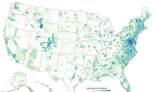
Aaron Renn of Urbanophile calls our attention to a NYT piece ("How close is your community to every state in America?"), headlining it "State Boundaries Are Real," making the point that based on a study of Facebook relationships, people's relationships tend to be pretty close to home--intra-county first, intra-state second, and not much for crossing state boundaries, even when counties abut state boundaries.
I asked Aaron about it, hypothesizing the greater likelihood of such connections across state boundaries in the Washington Metropolitan Area (which includes DC and parts of Maryland, Virginia, West Virginia, and when connected with Baltimore, Pennsylvania) could be an exception.
It turns out this is the case. The only real case.
DC and Maryland, and the entire DMV--DC, Maryland and Virginia--are the primary exception, nationally.
I understand the DC-Maryland connection, because DC is physically connected to Maryland, while it is separated by a river from Virginia, but cross-county/cross-state connections are strong throughout the Washington Metropolitan Area.
And similarly situated cross-state metropolitan areas where suburban and exurban areas are tied to the center city especially in terms of employment, in particular Philadelphia-NJ-DE and New York City-New Jersey, and to a lesser extent Boston and Chicago, do not have the same level of intensity of connections.
But there is greater than average connection between Kansas City Kansas and Kansas City Missouri, but much less strong compared to the DMV.
He shares with us a higher-resolution image that you can click through on.
Labels: demographics, social capital
posted by Richard Layman @ 12:53 PM&Permanent Link
![]()
![]()


3 Comments:
I think the NYtimes highlighted DC as an example of a "national" pattern.
And looking at the map, I'd say "Greater DC" is basically Howard, MoCO, PG and charles county. Not NOVA.
Again why DC should give up on UDC and make UMD its state school.
I've written from time to time suggesting DC could operate like the SUNY organization, as opposed to the SUNY schools. SUNY contracts with Cornell to provide land grant programs, with Alfred U to provide land grant programs, with Syracuse in part for the now independent ESF, even though they are private schools.
I suggested DC could contract with one or more of the private schools for "local college."
and I have written a bunch that DC should have co-created a community college with Montgomery College or PG Community College -- although the Metrorail connections for PGCCC aren't very good, so I'd say MC as campuses in Rockville and Silver Spring are reasonably Metro accessible.
But I think you're right about UMD ultimately being the better choice because as the state's major university it has the widest range of programs.
====
wrt your point about "Greater DC" not so much including NoVA. Yes. I do think that's because of the river... by contrast we are connected directly to PG and MC, and pretty close to Charles and Howard...
That being said it's higher between DC-NoVA than in comparable areas.
off topic:
https://www.citylab.com/perspective/2018/09/cities-have-their-limits/569716/
Post a Comment
<< Home