Rebuilding Place in the Urban Space

"A community’s physical form, rather than its land uses, is its most intrinsic and enduring characteristic." [Katz, EPA] This blog focuses on place and placemaking and all that makes it work--historic preservation, urban design, transportation, asset-based community development, arts & cultural development, commercial district revitalization, tourism & destination development, and quality of life advocacy--along with doses of civic engagement and good governance watchdogging.

Saturday, December 16, 2023

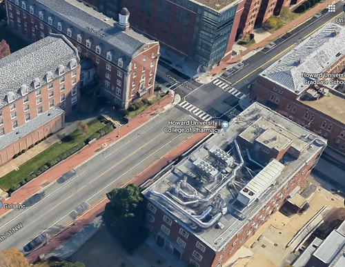
Mayor Bowser gets shade for claiming every transit line serves Gallery Place | Capital One Arena and point about Downtown planning

Technically, Mayor Bowser is wrong because Galley Place is served directly by the green, yellow, and red lines, while nearby -- a few blocks -- Metro Center, has the blue, orange and silver lines along with red ("DC Mayor Muriel Bowser forgets which Metro lines service arena stop while defending keeping teams downtown," Washington Examiner).

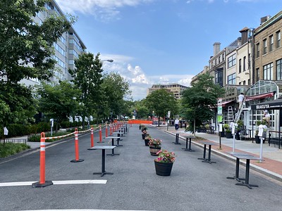
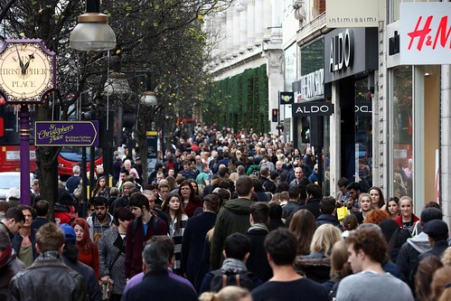
But not many people seem to know it's easier and faster to get out and walk.  So they congest the red line between the two stations when going to games.

Although there has been talk for almost 20 years about creating an underground walkway between the stations (GALLERY PLACE / CHINATOWN - METRO CENTER PEDESTRIAN PASSAGEWAY TUNNEL STUDY, WMATA, 2006).

The last I remember the cost was going to be about $200 million and there wasn't the belief it was worth it.

HOWEVER, it does remind me of the late 1960s Urban Design Manhattan report by the Regional Plan Association, which called for more purposeful vertical and horizontal planning between Manhattan's transit stations, the street ground plane, underground entrances to buildings, and the first couple floors of buildings.

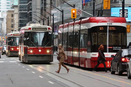
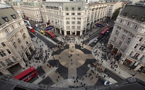
When MTA interlined a bunch of lines, they had the opportunity to build an integrated system of underground connections, comparable to Chicago's Pedway, Toronto's PATH network and Montreal's Underground City, but instead they just filled it in.

DC could have taken the opportunity with both a Metro Center to Gallery Place connection and a Farragut North to Farragut West connection, to begin to do a similar kind of pedway network, and strengthen the value of Central Business District.


Chicago Pedway

Other opportunities are presented by the proposed Downtown Maglev station ("DC, Transformational Projects Action Planning, and the Baltimore-Washington Maglev project") and in terms of vertical and horizontal connections, the NoMA station ("Public improvement districts ought to be created as part of transit station development process: the east side of NoMA station as an example," Revisiting creating Public Improvement Districts in transit station catchment areas").

DC hasn't been particularly forward on constantly planning and investing in maintaining the value and centrality of the Downtown Central Business District.  Given how voracious Northern Virginia is in recruiting DC based businesses, plus having other advantages (airport access, lower rents, cheaper and more land, but sprawl), this is extremely short sighted.

Labels: , , , , ,

Saturday, December 09, 2023

Salt Lake City Weekly Gift Guide 2023 includes "community/government wishes"

 -- "City Weekly's year-end guide to getting through the holidays and closing out those Christmas lists. GIFT GUIDE 2023"


They list:

  • Ranked choice voting -- the state allows this for local elections
  • Mid-block crossings on State Street -- not allowed, even in Downtown Salt Lake, because it is a state road, controlled by the Utah Department of Transportation
  • the rote election of Celeste Maloy to replace Congressional Representative Chris Stewart, who resigned.  The Utah Legislature super gerrymanders Salt Lake County, dividing it into all four Congressional districts, so no Democrat can be elected to represent the center of the state
  • getting the signal for the 2034 Winter Olympic Games, which could force the state to reinvest in infrastructure, e.g., the light rail system was built to support the 2002 Olympics.
With regard to the last point, it's something I will be writing about.  11 years is enough time to be able to construct significant infrastructure.

Labels: , , , ,

Tuesday, November 28, 2023

I didn't know Cumberland Maryland "had" a pedestrian mall

 I've written a lot about pedestrian malls in the US (versus pedestrian districts in Europe).  It's hard to make them work because our mobility paradigm is dominated by the car, and because Downtowns are no longer leader centers and destinations within metropolitan areas, the way they were before the rise of suburban shopping malls.  But some cities, in particular college towns like Boulder and Burlington, Vermont, and to some extent Charlottesville, have them.

I've come to realize that the point isn't necessarily to have a long pedestrian mall, but to start small, where you can be successful, even with one block.  And to heavily program and manage it

-- "Planning for place/urban design/neighborhoods versus planning for transportation modes: new 17th Street NW bike lanes | Walkable community planning versus "pedestrian" planning," 2021
-- "Extending the "Signature Streets" concept to "Signature Streets and Spaces"," 2020
-- "From more space to socially distance to a systematic program for pedestrian districts (Park City (Utah) Main Street Car Free on Sundays)," 2020
-- "Why doesn't every big city in North America have its own Las Ramblas?," 2020
-- "Diversity Plaza, Queens, a pedestrian exclusive block," 2020

-- "Now I know why Boulder's Pearl Street Mall is the exception that proves the rule about the failures of pedestrian malls," 2005

That being said, many places, including DC, have removed pedestrian malls over the years.

The DMV region has two pedestrian malls that I knew about, in Charlottesville and Winchester Virginia.  Both tend to peter out at the ends.  (As does the pedestrian mall in Santa Monica, especially as it has over the years lost department stores as key anchors.)

I didn't know about Cumberland Maryland, which was mentioned recently on the Reddit Walkable Streets thread.  

However, they are tearing up all that beauty and investment, and adding a traffic lane, which makes it less than a stellar example ("Downtown mall work on schedule," "Downtown construction includes unexpected challenges,"  Cumberland Times-News).

-- Reimagine Cumberland

It's a shame because photos indicated that the mall was super well executed, managed and maintained.  That being said, I guess infrastructure improvements are necessary, and for the most part, they will be keeping the overall focus on walking, not driving.

Flickr photo by Jacqui Trump.

Photo: Steve Bittner/Times-News.com 
Construction continues on Baltimore Street on Thursday, July 13, 2023.

Rendering of the newly constructed pedestrian mall

Labels: , , , , , ,

Thursday, February 02, 2023

Pedestrian wayfinding signage in Thessaloniki is adding information of the calorie burning value of walking

That's pretty creative.  And something that should be done for every center city wayfinding system.

A number of years ago, I wrote an article on culture-based revitalization in Thessaloniki for the Europe in Baltimore program sponsored by the EU National Institutes of Culture Washington Chapter.

-- "Thessaloniki: Regeneration as an ongoing process"

And in the Bangkok Metro system, they have painted similar information on stairway risers.


Again, a good idea that needs to be implemented in more public places as a way to promote healthy mobility behaviors.


Labels: , , , ,

Monday, September 12, 2022

Madison Wisconsin should be rethinking its pedestrian "district"

Unlike Western Europe, where many cities still have pedestrian districts that thrive at the center of their towns, despite the post-war adoption of the automobile as the primary form of mobility, the US pretty much dropped interest in pedestrian districts and city centers as it adopted the automobile.

In 1959, starting in Kalamazoo, Michigan ("Kalamazoo Mall, nation's first pedestrian mall, opened 60 years ago today," Kalamazoo Gazette), pedestrian malls were created in many cities as a last gasp measure to resuscitate city shopping districts in the face of competition from suburban malls, but for the most parts, these efforts failed and the malls were torn out and returned to automobile traffic.

One exception was pedestrian malls in college towns, where because a lot of the area population didn't have cars--college students--walking still was a dominant element of the mobility mix. (There are still pedestrian malls in non-college places like Santa Monica, California and Winchester, Virginia.)

College towns in Burlington, Vermont, Madison, Wisconsin, Boulder, Colorado and Charlottesville, Virginia are probably the most successful examples.

I wrote about Boulder's in 2005, "Now I know why Boulder's Pearl Street Mall is the exception that proves the rule about the failures of pedestrian malls."


So I often was critical about efforts to create similar districts in "today's circumstances" because the reality is that most cities and sub-districts don't have the volume of pedestrian traffic necessary to keep pedestrian exclusive places activated.  

Plants and planters aren't enough, you need people.

Although I have to say that I "came to my senses" in a way, not just because of the rise of the parklet movement and a wide variety of pro-pedestrian urban design initiatives, but because I came to realize that the issue was more about "rightsizing," that thinking about a multi-block mall was likely to be unsuccessful, but starting with one block in the places where a one block pedestrianized section can be successful is enough.  And it can be built from.

More recently, I've come to think about this in terms of "planning for walkable communities" versus "pedestrian planning."

-- "Land use planning is upside down by not focusing on maintaining and strengthening neighborhoods," 2022
-- "Extending the "Signature Streets" concept to "Signature Streets and Spaces"," 2020 
-- "Planning for place/urban design/neighborhoods versus planning for transportation modes: new 17th Street NW bike lanes | Walkable community planning versus "pedestrian" planning," 2021
-- "The layering effect: how the building blocks of an integrated public realm set the stage for community building," 2012

Madison Wisconsin: its pedestrian mall and nearby State Street.  But this comes up because the University of Wisconsin is doing a plan update for its section of the campus, Library Mall, abutting Madison's pedestrian mall, State Street Mall, and the local newspaper suggests that the City of Madison should join in and make it a joint planning process ("UW thinks big about pedestrian mall — the city of Madison should, too," Wisconsin State Journal).  From the article:

UW-Madison wants to reimagine and energize Library Mall in the heart of campus with stylish walkways, native plants, shade trees and splashing water.

The university’s $6 million plan looks good so far, with a fundraising campaign on the way.

Similarly, the city of Madison should be thinking big about nearby State Street, its premier shopping and entertainment district that runs between campus and the state Capitol. State Street needs more attention and investment as city buses prepare to leave the bottom half of State Street next year.

The most promising and exciting idea — one that civic leaders have talked about for decades — is turning State Street into a grand promenade. Instead of a river of concrete running its entire length, State Street should become an urban park catering to walkers, shoppers, sidewalk cafes, art, music, small business kiosks, trees, public events and more.

The lesson that I learned from the article about Boulder is that it isn't just about the design, and having lots of pedestrians, it's also about on-going management.  And, but I didn't take it as an overt lesson, planning, to ensure that the pedestrian district remains exciting and relevant in the face of changes in retail, entertainment, programming interests, etc.

What the paper is suggesting really is the creation of a pedestrian district, building on the success of Library Mall ("UW shares $6 million concept to dramatically reimagine Library Mall," WSJ), and strengthening Downtown Madison, especially in the face of how covid and the rise in work from home has reduced office district patronage and demand ("New proposal could make State Street a pedestrian mall on weekends this summer," WSJ).

Although it's unfortunate that this didn't seem to occur to either campus planners at UW or city planners.  Although I am not surprised because again, we don't tend to look at planning more organically and at the larger scale of the "walkable community."

Ann Arbor: Making State Street a curbless street.  There isn't a "pedestrian mall" at the University of Michigan, but central campus is pretty well integrated into the nearby commercial districts, so "the need" for a pedestrianized district isn't particularly pronounced. 

Plans for a redesign of the State Street commercial corridor in downtown Ann Arbor as presented to the city's Transportation Commission by the Downtown Development Authority and SmithGroup in January 2022.

Ann Arbor is redesigning and reconstructing State Street in the vicinity of the campus to be a "curbless street," which theoretically is a pro-pedestrian treatment ("Construction begins on downtown Ann Arbor’s first curbless street," Ann Arbor News).

But the design for State Street seems pretty automobile-centric.  Looking at the rendering it doesn't come across as a curbless street at all, at least if a curbless street is defined as being pro-pedestrian.  

But I suppose it is a start.

Exhibition Road in London is much better design-wise (Guardian review, 2012).  It doesn't come across so well in this photo which was taken early in the day before the museums had opened.

But problems with "the design" are evident in that pedestrian-car crashes were frequent.  

Proving to me that in car-centric places like the UK and the US, "shared spaces" can be extremely problematic.

Labels: , , , , , ,

Monday, February 22, 2021

Gimbels Passageway to Penn Station versus the Socony-Vacuum Passageway to Grand Central Station

This is relevant to past entries making the point that horizontal and vertical connections to, from, and around transit stations need to be better planned as part of station development projects and station area planning.

-- "Public improvement districts ought to be created as part of transit station development process: the east side of NoMA station as an example," 2016
-- "Revisiting creating Public Improvement Districts in transit station catchment areas," 2020
-- Urban Design Manhattan, 1969, Regional Plan Association

Gimbels Passageway and Penn Station, New York City.  When writing the previous piece which referenced the PATH transit system serving Lower Manhattan and New Jersey, I came across a mention of the Gimbels Passageway, which had provided a direct underground connection between Penn Station, the 34th Street-Herald Square subway station and the 33rd Street PATH Station, via a sub basement in the Gimbels Department Store.

Gimbels went out of business and eventually the building was redeveloped into the Manhattan Mall, with a food court on the bottom where the passageway was.

The passageway was closed in 1986 when the city was in decline.  Partly the dispute was over who should pay for improvement and maintenance, and who owned the property, MTA or the real estate developer, now Vornado.  

In any case, the passageway has been shuttered ever since, although in 2010 the owner, Vornado, claimed they would reopen it someday as part of an office project ("Remembering the Gimbels Tunnel," New York Post).

Missed connections between Penn Station, the Herald Square subway station and the 33rd Street PATH Station

Map of the PATH transit system

Lost opportunity with the Moynihan Station project.  I find it shocking that as part of the expansion of the Penn Station complex with the addition of the Moynihan Station train hall, that the opportunity to revive the passageway didn't come about, especially since Vornado is part of the consortium that created the Moynihan Station.  (Also see "PATH to Penn Station: Restoring an Underground Passage to Streamline NYC Transit," Stewart Mader.)

The station had its grand opening in January which opened in January, 

-- "New York’s new Moynihan Train Hall is dazzling but flawed. Philly should do better," Philadelphia Inquirer
-- "Moynihan Train Hall: It’s Stunning. And, a First Step.<" New York times

One Vanderbilt and Grand Central Station.  By contrast, the development of the One Vanderbilt Avenue project adjacent to Grand Central Station has resulted in a slew of improvements, including the restoration and reopening of the old underground passageway between the old Socony-Vacuum Building and Grand Central Station.


While I understand New York City subway's underground passageways tend to be simple in design, there is an opportunity for public art in some of these tunnels, such as the underground passageway light exhibit connecting to Essen Germany's main train station.


To get approval of the controversial One Vanderbilt project, the developer SL Green committed to funding and/or constructing $220 million worth of transit and mobility improvements, including the underground passageway ("Behind the rise of the 77-story One Vanderbilt," New York Post).

Labels: , , , , , ,

Monday, January 11, 2021

Extension of the High Line "park" to Penn Station in New York City as an element of the pedestrian mobility network

Last week's insurrection interfered with my writing plans.  Instead I doomscrolled for the rest of the week, reading all sorts of coverage.

Once the mail sorting room of the 1912 James A. Farley Post Office Building, this vaulted space is now the central highlight of Moynihan Train Hall, which opened at the end of 2020 as a much-needed extension to New York’s Penn Station. Photo: Lucas Blais Simpson, SOM.

One in-process piece uses the opening of the new Moynihan Train Hall extension to Penn Station ("Moynihan Train Hall is a New Year’s Gift to New York City," Metropolis Magazine) as a jumping off point for repositioning "national" railroad passenger planning at multiple scales.

A 1,200-foot elevated walkway will connect the existing elevated park at 30th Street to a pedestrian path at Manhattan West.Credit...Office of Governor Cuomo.

A related element is the proposed extension of the High Line elevated linear park to Penn Station ("$60 Million High Line Expansion to Connect Park to Moynihan Train Hall," New York Times).

Then it can become a more purposive element of the horizontal mobility network, not "merely" a park. 

In the second plan for Manhattan, c. 1969, produced by the independent nonprofit the Regional Plan Association, there is a great document Urban Design Manhattan which looks at horizontal and vertical and separated plane mobility elements between transit stations, the surface and buildings. 

It's a great template for thinking about horizontal and vertical connections as more planned elements within the mobility system, especially at transit stations.  

Stairway connecting 1st Street SE to New Jersey Avenue in Capitol Hill, Washington, DC.

Places like Chicago and Toronto that have related underground pedway networks, Minneapolis and St. Paul with their above-ground skyway networks, the various improvements finished or underway around Grand Central Station in New York City, and stairway, escalator, gondola/aerial tramways, and elevator connections in various places ranging from Hong Kong to Medellin to Portland, Oregon to Berkeley, California to New York City to Monaco are practical examples of how to do this.

I expound on the concept here in this piece, "In many places) Public improvement districts ought to be created as part of transit station development process: the east side of NoMA station as an example," although the piece starts out by discussing financing and implementation mechanisms.

Public escalator in Commune 13, Medellín. AP photo by Luis Benavides.

While this piece aims at creating a complete framework for the elements of mobility, "Further updates to the Sustainable Mobility Platform Framework."  The framework needs an update. In the interim, I add bits and pieces through the comments section.

Labels: , ,

Wednesday, July 01, 2020

Revisiting pedestrianizing the 1500 block of 19th Street NW in Dupont Circle

Recently, the entry "" discusses how to make pedestrian and bicycling right of way expansions in the wake of the coronavirus a more permanent condition.

In 2019, the entry "Planning urban design improvements at the neighborhood scale: Dupont Circle, DC," discusses a systematic program for urban design improvements in and around Dupont Circle.  It was an outgrowth of my Purple Line series-thinking, although it took me a couple years to get around to writing about it.

One of the recommendations, Item #5, was pedestrianizing the 1500 block of 19th Street NW, which is the block with the Dupont Plaza Hotel on the east and the block of businesses on Connecticut--many have rear entrances, anchored by Kramerbooks and Afterwords Cafe, the combined bookstore-cafe that is open 24 hours on weekends (in normal times) and a very busy Starbucks.

5. Make 19th St. between the Circle and Q Street a permanent pedestrian street
(but with access for deliveries.)

Joe Flood, via Flickr, shares with us his photo of this block, set up for expanded restaurant patio service.
Untitled

I made a similar recommendation, starting with weekends, for 17th Street:

6. Make 17th Street between P and R Streets a pedestrian district on weekends.


17th Street NW, Dupont Circle

And from an update standpoint, instead DDOT and the Washington Area Bicyclists Association, is pushing the addition of a cycletrack to 17th Street, which would get in the way of pedestrianizing it.

Given the pedestrian volume in the area, and the need for this commercial street section to have a positioning that is more distinct vis a vis neighboring 14th Street and Dupont Circle as a way for its establishments to be more competitive, emphasizing and strengthening its pedestrian character should be prioritized over cycling--especially given nearby parallel routes, and let's face it, relatively low volumes of bicyclists.

In the past I've suggested that WABA reposition from a cyclist-exclusive orientation to a more expansive "sustainable mobility" agenda like Transportation Alternatives in NYC and Active Transportation Alliance in Chicago (formerly the Chicago Bicyclists Federation), they haven't done so.

So there isn't a good pedestrian advocacy group in the city--robust examples elsewhere include Feet First in Seattle, Starkville in Motion in Mississippi (although they do biking too), Walk Boston and Walk Denver--and therefore in DC the pedestrian agenda can too often be neglected.

Labels: , , , , , , ,

Wednesday, September 11, 2019

Special sidewalk intersection treatment in Berwyn, Maryland on Route 1

Special sidewalk intersection treatment in Berwyn, Maryland on Route 1

One of the many pieces I haven't written is about a set of prescriptions for "branding" your community as supportive of sustainable mobility, with high profile initiatives around the support of walking, biking, and transit.

Imagine urban design treatments like this being implemented at the neighborhood scale.

.. although some cities do much more of this (Seattle especially) than others.


Labels: ,

Wednesday, August 14, 2019

Big urban design miss at Catholic University

Lighted M Metrorail sign pylon at the Brookland Metrorail Station, WMATA
While converting the on campus street that extends from the Brookland Metrorail Station into the  Catholic University campus is a big improvement for the pedestrian experience and a win for sustainable mobility, they failed to maximize the opportunity of the project because they did not:

(1) extend this treatment across John McCormack Road to the Metrorail station

(2) by reconfiguring the geometry of the connection from the east side of the street to the west side of the street.  The jog between the campus walkway and the crosswalk from the Metrorail station has been maintained, rather than extending the campus walkway across McCormack Road with a new pathway between the Metrorail station and the campus, rather than maintain the current jog between the two

(3) the enhanced urban design treatment, in particular the brick pavers, should have included the crosswalk.at a minimum.

Granted it probably would have been difficult to work with WMATA as improvements would have required their cooperation, as well as DC Department of Transportation, which controls John McCormack Road.

And fortunately, between Michigan Avenue and this point, the road isn't used by many vehicles, which reduces the chances for conflict between motor vehicles and pedestrians.

New entryway at Catholic University, connecting to the crosswalk to the Brookland Metrorail Station

New entryway at Catholic University, connecting to the crosswalk to the Brookland Metrorail Station

Benches and the Metropolitan Branch Trail adjacent to the Brookland Metrorail Station
Benches and the Metropolitan Branch Trail adjacent to the Brookland Metrorail Station.


Counterpoint.  Years ago, after Howard University built a bunch of new dorms behind the campus, along 4th Street NW, extending the concentration of dormitories there, I suggested to the then DC planning director that the street should be enhanced with pedestrian-focused urban design changes, including special paving treatment for the street and intersection improvememnts.

Howard UniversityShe countered that would mean "Howard University taking over the street."

You could say the same thing with the connection between the CUA campus and the Metrorail station across the street.

But I disagreed with her then because the point ought to be in recognizing land use conditions and seeking the best possible outcome, with the preference on improving and extending the pedestrian experience and character of the city.

In both cases, sustainable mobility choices need to be preferenced, with the aim of discouraging car use and increasing the use of transit, biking, and walking.

Conclusion.  While Catholic University's creation of the pedestrian walk from the Metrorail station is to be commended, it must be acknowledged that they had the opportunity to make it transformative, and they blew that opportunity.

Labels: , , ,

Wednesday, July 17, 2019

Car in the Crosswalk on Colesville Road at the Silver Spring Transit Center

Car in the Crosswalk on Colesville Road at the Silver Spring Transit Center

So tiresome.

There is a cover of the Saturday Evening Post that is similar.

Thornton Utz, "Blocking the Crosswalk," September 17, 1955
Thornton Utz cover, "Blocking the Crosswalk," Saturday Evening Post Magazine, September 17, 1955

Labels: , , ,

Saturday, September 22, 2018

Guardian "Walking the City" series

In advance of today's World Carfree Day ("World Carfree Day: Saturday September 22nd), the Guardian has been running a series of articles called "Walking the City."

I wanted to have a feature on applying pedestrian streets principles in DC, not for long streets called pedestrian malls, but for a block or two, here and there around the city, where it can work.

In the past, I've been negative when pedestrianized districts have been proposed in DC (e.g., "How to f*** up 17th Street NW in Dupont Circle," 2007) but now I realize I was too much influenced by the first pedestrian mall I ever saw, in Kalamazoo in 1986, and its relative failure.
Burdick Street Pedestrian Mall Kalamazoo MI
It did not look this vibrant when I saw it.  This postcard is from the 1960s.

Kalamazoo Pedestrian Mall in the 1980s, after the JC Penney closed
Kalamazoo Pedestrian Mall in the 1980s, after the JC Penney closed.

I remember being very surprised at the Dutch ThinkBike workshop in 2010, when one of the facilitators pointed out DC doesn't have any pedestrianized areas and shouldn't that be something to be addressed?

-- "Reprint from 2010: The Dutch ThinkBike workshop in DC,"

In the US, pedestrian malls that are successful tend to be in college towns, but not exclusively such as Third Street in Santa Monica, places with a preponderance of people without cars.  In the region, Charlottesville and Winchester have pedestrian malls that remain successful, albeit with some property vacancies.

Charlottesville

For pedestrian malls to be successful, they need to be well designed, well managed, well programmed, and perhaps most importantly, highly visited because empty spaces don't attract visitors they repel them.

-- "Now I know why Boulder's Pearl Street Mall is the exception that proves the rule about the failures of pedestrian malls," 2005
-- "K Street: Last of the pedestrian Malls," Sacramento Business Journal, 2009

But the thing I had to get over is thinking about this in terms of long pedestrian malls or large pedestrian districts like in Essen, Hamburg, or Liverpool, and more in terms of one or two blocks, here and there, where it makes sense in the local context.

And building on and extending from there.  Like what I suggested a few weeks ago for Silver Spring, Maryland.

-- "Making "Downtown Silver Spring" a true open air shopping district by adding department stores

And no, I am not talking about "shared spaces" where pedestrians mix with cars.

More on this next week.

Labels: , , , , , , ,

Thursday, September 20, 2018

Parking Day this Friday | An in-street restaurant patio for Takoma Beverage Co. using parking spaces, Carroll Avenue, Takoma Park, Maryland

Port-a-park: A temporary park was set up in a parking space on Mission Street by Rebar, an art collective.
The group Rebar declared Sept. 21 "Park(ing) Day" and installed this temporary park in a parking space on Mission St. in downtown San Francisco, CA. The group moved the park to several different parking spaces throughout the day. Port-a-park: A temporary park was set up in a parking space on Mission Street by Rebar, an art collective. The park was moved several times that day. Chronicle photo by Laura Morton.


In 2006, a planning/artist collective in San Francisco called Rebar Group created what they called "Parking Day," to demonstrate the high cost to placemaking from dedicating so much public space to the automobile, for car storage ("Drop a coin in the meter and enjoy the park," John King,San Francisco Chronicle, 2006)

This event has become a world-wide phenomenon, existing and expanding beyond that of Re:bar which disbanded a couple years ago.

But Parking Day is important in how it sparked a greater focus on placemaking and public space not just within planning departments but also transportation departments and citizen advocates.

And it continues, as it will be held this Friday, and is held every year on the Third Friday in September.

-- ASLA Parking Day webpage (the Parkingday.org web domain is somewhat lost but still has valid info)
-- DC DDOT Parking Day 2018, which lists 28 participants
-- a Google News search finds many participants across the US
-- and in Singapore there will be 109 examples, "PARK(ing) Day: Green light for fun at some carparks Straits Times

While Parking Day is an ephemeral event and too often fails to spark deeper structural changes ("Walk to School Day and Park(ing) Day as missed opportunities for community organizing," 2013), in many communities it has led to the creation of more permanent initiatives including in-street permanent "parklet" ventures.

-- San Francisco Sustainable Mobility and Climate Action Strategy
-- "Long Beach joins the national 'parklets' trend: Three restaurants have won city approval to convert a few highly valued parking spaces into green space. In some cities, the parklets are open to the public, but these will be for patrons' use only," Los Angeles Times
-- "Sunset Triangle Plaza: LA's First Pedestrian Plaza Conversion is Now Open!," Inhabitant
-- People Street Parklet Program, City of Los Angeles
-- Pavement to Parks research initiative, San Francisco
-- Reclaiming the Right of Way: A Toolkit for Creating and Implementing Parklets, UCLA

It also helped to spawn the "tactical urbanism" movement.

-- Tactical Urbanism Volume 1
-- Tactical Urbanism Volume 2
-- Better Block Foundation
-- City Repair,Portland (effort pre-dates Rebar Group, and probably influenced it)
-- City Repair's Placemaking Guidebook, second edition
-- Neighborista, a blog on creative tactical urbanism projects
-- Tactical Urbanism Public Space Stewardship Guide
-- Tactical Urbanist’s Guide to Materials and Design

Note, that's "tactical urbanism" not "temporary urbanism" ("Building the arts and culture ecosystem in DC: Part One, sustained efforts vs. one-off or short term initiatives," 2015).

Sunset-Triangle-Plaza-Rios-Clementi-Hale-Studios-2-537x357
Sunset Triangle Plaza, Rios-Clementi-Hale-Studios

But not in the DC area, at least in terms of making over parking spaces permanently for parklets and patios.

Although we have to acknowledge the greater use of space formerly dedicated to parking for bike lanes and bike parking.
15th Street NW cycletrack
15th Street NW cycletrack in early stages, when drivers still were learning about them.

Bicycle corrall, 11th Street NW, Columbia Heights
Bicycle corral, 11th Street NW, Columbia Heights

And some other examples of redirecting interstitial spaces away from the car. Foremost was the taking away of traffic lanes in 2005/2006 to expand Thomas Circle, returning it to its original size in a move that pre-dated the parklet movement.

This example from the northeast corner of the intersection at 5th Street and New York Avenue NW is more recent.

5th Street and New York Avenue NW, northeast corner, 2017
2017

5th Street and New York Avenue NW, northeast corner, 2008
2008

So I was surprised yesterday to see that in Takoma Park,Maryland, the Takoma Beverage Company has expanded their restaurant patio into the parking lane, taking up two one additional space beyond the sidewalk section.

Note that Takoma Bev Co is a combo "coffee shop" and bar and the food is good, and reasonably priced.

I believe it is the first example in DC, Montgomery County, Arlington County, or Alexandria where "interstitial parking space" is being dedicated permanently to parklet-type use.
An in-street restaurant patio for Takoma Beverage Co. using parking spaces, Carroll Avenue, Takoma Park, Maryland

According to Suzanne Ludlow, City of Takoma Park City Manager:
As you may have noticed, Takoma Beverage Company is the first of our local restaurateurs to take advantage of the City’s new Outdoor Café Permit, approved by the Council this past summer.  The new permit allows businesses like Takoma Bev Co. to offer outdoor seating to patrons wishing to take full advantage of their menu offerings. 
The permit, which allows for the use of the City’s right of way (which can include on street parking spaces), requires the business to submit a site plan illustrating how the outdoor café will be laid out, provide liability coverage for the City, and be in full compliance with all food and beverage requirements established by Montgomery County.  
Permits can be issued for three month, six month, or twelve month periods. The outdoor locations will be monitored on a regular basis by City staff to ensure that sidewalks allow for the free flow of pedestrians and that the business is complying with a variety of other local laws including the polystyrene ordinance and the property maintenance code.

The one tricky thing is on Sundays, when this space is used by the Takoma Farmers Market. It has to be pulled up then.

The new extended patio has been in place for not quite two weeks.

Labels: , ,

Wednesday, July 26, 2017

It's been a drawn out process, but DC is in the process of creating transitways on 16th Street NW

It's been a drawn out process, but DC is moving on creating dedicated transitways on 16th Street NW, which is home to the S bus line between Downtown and Silver Spring. The line has upwards of 25,000 daily riders, which is the highest ridership bus line in the Washington metropolitan area.

-- 16th Street Bus Lanes Project website
-- 16th Street NW Transit Priority Planning Study, DC Department of Transportation
-- "D.C.'s 16th Street on track to get a bus lane," Washington Post, 2016
-- "Bus lanes coming to 16th Street, but it could cost you some parking," Post

July 27: Public Meeting
What: 16th Street Bus Lanes Project (Design Phase) – Public Meeting
When: Thursday, July 27, 2017 from 6 to 8 p.m.
Where: Columbia Heights Educational Campus - Cafeteria, 3101 16th Street NW

August 1: Public Engagement Event
What: 16th Street Bus Lanes Project (Design Phase) – Public Meeting
When: Tuesday, August 1, 2017 from 4:30 to 7 p.m.
Where: Two Locations: 16th Street NW at U Street and 16th Street NW at Irving Street

More recently, DC has introduced transitways painted red on a few blocks of Georgia Avenue, near Howard University and U Street, and recently extended this by one block between T and U Streets on southbound Georgia Avenue.

-- "Dedicated bus transitway on Georgia Avenue NW," 2016

Before the automobile completely dominated the DC metropolitan area's mobility paradigm, there were transitways. They were dropped around the time that Metrorail was implemented.

-- "We had bus lanes a half century ago and we can again, PlanIt Metro blog, WMATA, 2014

Dedicated transitways need to be considered a basic element within the urban mobility toolkit.

DC should take heart from similar kinds of very transformative projects elsewhere, and make sustainable mobility the priority, taking transformative measures here.

San Francisco.  Over the weekend, I came across a vintage postcard of Market Street in San Francisco, showing four tracks-- two (!!!!!!) streetcar tracks in each direction.

Although motor vehicle traffic was still allowed there is no question that streetcars dominated the landscape, and moved far more people than a typical two track set up.

A four track set up has the capacity to move more than 100,000 people per day, even with comparatively slow streetcars.
Market Street, San Francisco, vintage postcard, showing four tracks for streetcars

A long time ago, that was been slimmed back to two, and two streetcar tracks--one in each direction--is the typical set up across the US, as it is on Market Street today.
Street Scene on Market Before Transit Priority Lanes

More recently, SF has introduced transit priority lanes on Market Street, and there are a variety of proposals for rebalancing throughput towards sustainable modes.
141015_SVN_113
This and previous photo: SFMTA.

-- A Better Market Street, SF County Transportation Authority

King Street, Toronto.  More recently, Toronto has begun the process of changing the traffic configuration to prioritize streetcar traffic on King Street.  They will test for one year a change that disallows through traffic by motor vehicles.
Streetcars at Yonge and King Streets, Toronto
Streetcars at Yonge and King Streets, Toronto. Photo: Steve Russell, Toronto Star.

The line there, the 504, is the busiest in the city, moving more than 65,000 people daily.  It makes sense to prioritize the streetcar, which moves far more people than cars, which make 20,000 trips on the street each day.

-- "King St. streetcar plan is a cautious first step with room to grow," Toronto Star

Imagine what streetcar throughput could be if there were four active tracks, and no motor vehicles, not even taxis.

Oxford Street, London.  Oxford Street is one of London's main shopping streets, which pedestrian traffic greater than that of the King Street Streetcar.  The street is clogged with buses and taxis--London's congestion charge does a reasonable job of reducing motor vehicle traffic.

oxfordstreetshopping
Oxford Street Shopping.  This and next photo: Getty Images.

Oxford Circus, europes-largest-diagonal-crossing-is-launched-on-oxford-circus-92608299-57cd28b88e21c
The diagonal crossing at Oxford Circus is Europe's largest.


The proposal is to fully pedestrianize Oxford Street.  Today, 500,000 people on average patronize the street each day and this number will only grow when the Elizabeth Line of the Crossrail project opens next year, adding two more transit stations to the area.

Already, Transport for London is working to reconfigure bus service to move bus trips off the sections of the street with the most pedestrian traffic, and taxis will be banned as well.

-- "Oxford Street transformation to get underway by December 2018 as TfL and Westminster City Council launch consultation," City A.M.
-- "Four changes that need to happen before Oxford Street can be pedestrianised," City A.M.
-- "London's Oxford Street bus routes cut by 40%," BBC News

Not everyone is convinced it is the way to go.

-- "Oxford Street stores call on Mayor Sadiq Khan to tone down traffic ban," Evening Standard

Labels: , , , ,