Mobility best practices
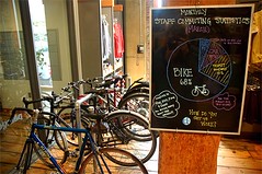
A blackboard at a Patagonia store in the Pearl District boasts that 68% of the staff’s commuting trips in March were by bicycle and 22% by bus, train or carpool. The store is housed in the EcoTrust Building, an 1895 brick landmark that’s been rehabbed since 1998 according to exacting green standards, from the garden on the roof to the weathered old floorboards. (Christopher Reynolds / LAT)
So I had a conversation with a DC transportation planning official on Saturday, and he said that the move in planning is from "mobility" to "accessibility." The Access to Destinations Study at the University of Minnesota defines the concept of accessibility thusly:
In the context of transportation studies, accessibility refers to the ability of people to reach the destinations they must visit in order to meet their needs, and desire to visit to satisfy their wants.
With that in mind, we should rethink the The Transit Metropolis of Cervero to the Mobility-Accessibility metropolis. (One of the problems with referring to accessibility is that people often think this concerns place access issues of the disabled.) In any case, the concept I have of the mobilityshed, and Bremen's Mobil Punkt -- mobility hubs, are part of the solution, overlaid with the idea of the Walkable community (see Dan Burden's article, "How Can I Find and Help Build a Walkable Community?").
As Ford Motor puts it in a press release, "FORD, UNIVERSITY OF MICHIGAN DEVELOP NEW MOBILITY AND TRANSPORTATION OPTIONS FOR THE FUTURE":
Working with U-M’s Sustainable Mobility and Accessibility Research and Transformation (SMART) program and local-market partners, Ford is developing “Ford Urban Mobility Networks.” The new program is designed to efficiently connect individuals to a variety of transportation options – buses, trains, taxis, car-share fleets, mopeds and bicycles – in urban areas where population growth is beginning to affect access to affordable personal mobility.
These transportation options are available through a transfer point or ‘hub’ where various modes of transportation and services come together. The hubs can be simple places where two modes of transport meet or they can be elaborate with many transport modes, along with services offering commuters information on entertainment, recreation, dining, banking, commerce, community services and more. The network of hubs is enhanced by information technology that provides real-time travel and schedule information, either at kiosks or through a personal communication device such as a mobile phone. A network of hubs throughout a city is connected to provide commuters convenient, safe and affordable trips.
From the mobilityshed standpoint, a hub is transit station or route, and hubs are planned to support multiple modes and build agglomeration benefits for accessibility. For example, the Fort Totten Metro Station has a big taxi stand, and of course serves as a transfer point from walking and bus to the subway lines. There is a parking lot for commuters. And a number of stalls have carsharing vehicles. Should better accommodations for bicycling be in the mix? Etc.
To get there, read "L.A. could learn a thing or two from Portland" from the Los Angeles Times and "Portland is a hub for the car-free and carefree" from USA Today, about Portland, Oregon.
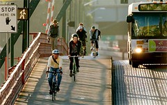
Finding an alternative to driving, commuters on bicycles pump toward downtown Portland, Ore., as a bus trundles alongside. In a town whose solar-powered parking meters bespeak a green mind-set, another incentive to ditch the car is a convenient streetcar line that links downtown and several inviting neighborhoods. Useful for residents and tourists alike, it the streetcar system costs a mere $1.70 to ride all day — or nothing if you stick to downtown’s “fareless square” — and complements a regional commuter train called MAX. (Dana E. Olsen / The Oregonian)
DC works better for transit than Portland. Far more people ride transit within DC and the region. (The DC region is larger than Portland's, while DC and Portland are about the same size.) However, Portland is better on three very important dimensions:
1. Linking land use planning to transportation planning.
2. Planning "more" equally for transit, bicycling, and walking when compared to most places where the car is the dominant form of transportation, and is the object around which most land use and transportation planning is focused.
3. The urban growth boundary (which to some extent--not enough--keeps in check some of the problems of sprawl).
Labels: accessibility, sustainable land use and resource planning, transportation planning
posted by Richard Layman @ 11:11 AM&Permanent Link
![]()
![]()


0 Comments:
Post a Comment
<< Home