Rebuilding Place in the Urban Space

"A community’s physical form, rather than its land uses, is its most intrinsic and enduring characteristic." [Katz, EPA] This blog focuses on place and placemaking and all that makes it work--historic preservation, urban design, transportation, asset-based community development, arts & cultural development, commercial district revitalization, tourism & destination development, and quality of life advocacy--along with doses of civic engagement and good governance watchdogging.

Monday, September 22, 2025

Trump Cancels Trail, Bike-Lane Grants Deemed ‘Hostile’ to Cars

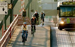
Bicyclists and pedestrians are on Martin Luther King Jr Dr, Sunday, Sept. 21, 2025 after the bridge over the Schuylkill River opened after more than two years in hiatus. Photo: Tom Gralish, Philadelphia Inquirer.  From "The MLK Drive bridge reopens to rave reviews from runners, bikers, and pedestrians."

The story from Bloomberg.  From the article:

The Trump administration canceled grants for street safety measures, pedestrian trails and bike lanes in communities around the country this month, each time offering a simple rationale for yanking back federal aid: the projects aren’t designed for cars.

A San Diego County road improvement project including bike lanes “appears to reduce lane capacity and a road diet that is hostile to motor vehicles,” a US Department of Transportation official wrote, rescinding a $1.2 million grant it awarded nearly a year ago.

In Fairfield, Alabama, converting street lanes to trail space on Vinesville Road was also deemed “hostile” to cars, and “counter to DOT’s priority of preserving or increasing roadway capacity for motor vehicles.”

Bicyclists, pedestrians, and power wheelchairs on the Martin Luther King Jr. Drive Bridge. 
Photo:Tom Gralish

... local officials and transit advocates said they were surprised by the language DOT used in rescinding previously awarded grants, and alarmed that the department seemed to be taking particular aim at programs that were designed to make streets safer for pedestrians and cyclists in a period of elevated traffic injuries and deaths.

... Despite rhetoric that associates non-car infrastructure development with liberal politics, “at the local level, there really isn’t that divide,” Mills said in an interview. Florida, he noted, is a red state with “extremely strong” plans to grow its network of mixed-use trails for bikes and pedestrians.
Transit planners increasingly have opted for alternative transit projects that can also alleviate automobile congestion, an approach Mills said is often more effective than car-focused projects. “These canceled projects may do that better,” he said.

=====

No surprise here.  Homogeneity in all things is a hallmark of the Trump Administration.  

The administration has shown its bias towards unfettering the motorist, starting with its opposition to the congestion toll zone in New York City.  And later eliminating transportation grants that called for equity in access for all users, not merely the primacy of motorists.

Labels: , , , , , ,

Wednesday, December 05, 2018

President George H.W. Bush

Yes, it bothers me that when past presidents die, most of the media coverage is hagiography and glosses over the bad stuff.  Such is the case with President George H.W. Bush, who among other things used highly racist campaign message and was involved, somehow, with the Iran-Contra affair.

There are some pieces out there saying that yes, President Bush was a gracious person, but that's not enough.

-- "The Media Got George HW Bush Wrong in Life and Death," New Yorker
-- "The Ignored Legacy of George H.W. Bush: War Crimes, Racism, and Obstruction of Justice," The Intercept

WRT transportation, mobility and accessibility, his administration wasn't against transit, the way the current Republican administration is, and he signed the Americans for Disabilities Act, which among other elements, requires that public spaces including streets, sidewalks, and transit, be accessible to the disabled.

-- Introduction to the ADA, ADA.Gov website
-- "Remarks of President George Bush at the Signing of the Americans with Disabilities Act," Equal Employment Opportunity Commission
-- Accessibility, US Department of Transportation

It turns out too that accessibility is helpful to everybody.  People with packages, people crossing streets, bicyclists, people pushing strollers, etc.

While most communities have made progress with this in terms of the sidewalk network, not all transit agencies have, including the New York City Subway system.

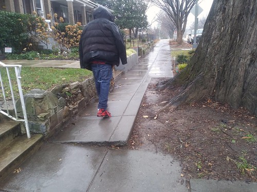
Sidewalk uplift, Kansas Avenue NWSidewalk uplift on Kansas Avenue NW.

Although communities may still miss important aspects.

For example, DC has an extensive program making sidewalks at intersections accessible (a lot of this is upgrading already existing ramps), but for the most part, doesn't address mid-block sidewalk problems, even when doing projects in close proximity.

I think that simultaneously, cities should prioritize mid-block repairs as well as intersection upgrades.

Labels: , , , ,

Saturday, October 06, 2012

A letter to the editor of the Pittsburgh Post-Gazette that you would never see in the Washington Post

I get frustrated, often, when I read letters to the editor printed in newspapers because on a factual basis, often the writers outline faulty arguments and an incorrect recounting of facts, but the newspaper doesn't include a counter argument with the facts, but just runs the letter, thereby readers infer that the statements are correct.

This is almost always the case with regard to letters about road use and paying for roads.  Even for the Washington Post, which considers itself one of the nation's best newspapers.

Most drivers, incorrectly, believe that their use of roads is fully paid by gas taxes, and this is reflected in letters to the editor and online comments on news stories.

Using Pennsylvania as an example since that's where the letter below was printed, the state gas tax is 12 cents/gallon and the federal tax is 18.4 cents/gallon for a total of 30.4 cents/gallon.

If the average motorist drives 10,000 miles/year and gets 25 mpg, then they buy 400 gallons of gas, paying a total of $121.60 in gas taxes. Or just over one penny per mile. It's more in states that pay more in gas taxes, for example, in California, where the state rate is 35.7 cents/gallon, it's just over two cents per mile.

I can't believe that anyone would think that's enough money to (1) maintain the roadway infrastructure, including bridges; (2) pay for the use of previously built roadways; and (3) build new transportation facilities.

-----
From the Pittsburgh Post-Gazette, "Cyclists do pay for roads":

I would have thought that the Post-Gazette had already given enough space for motorists to express their supposed rights to the road vis-a-vis cyclists based on the old pay-for-road-use argument (most recently Henry Peter Gribbin, "It's Time to Be Sensible About Sharing Streets," Sept. 17). Besides raising that often-repeated but fraudulent argument, Mr. Gribbin asks that cyclists be prohibited from using Forbes Avenue in Squirrel Hill.

First of all, cyclists are, by and large, car owners with bikes. I myself own two cars, both of them gas guzzlers, if that makes Mr. X any happier, so I do pay gasoline taxes and license fees.

More to the point, by far most of the city streets and secondary roads cyclists use are not paid for by gasoline taxes and automobile licenses but out of general revenue paid by everyone, whether they use the roads or not. And, while bicycles impose essentially zero wear on roads, cars additionally impose an estimated 6.5 cents per mile of road wear that eventually comes due (as is only too evident in and around Pittsburgh). Everyone is forced to pay for that 6.5 cents per mile per car just by being a taxpayer, whether they contribute to road deterioration or not.

Cyclists don't deserve the imposition of a road-use fee as much as they do a tax rebate. I would be willing to cut out the middleman and accept a check directly from Mr. Gribbin. The busy stretch of Forbes Avenue he wants to ban bicycles from has two of Pittsburgh's largest bicycle dealerships on it.

A better idea would be to ban motorized traffic on this stretch. As Mr. Gribbin correctly points out, there are lots of parallel streets that cars could use instead.

Anyone who wants to contribute intelligently to this discussion should first consult Google under "who pays for roads" and read a few of the many articles cited there.

OSCAR E. SWAN
Squirrel Hill

-------
1.  Actually, a bunch of the online comments on cited letter <"It's Time to Be Sensible About Sharing Streets" are negative in terms of his pro-car argument.  ("Sharing" from the perspective of many motor vehicle operators is more about privileging the auto.)

2.  I didn't know the 6.5 cents/mile of road wear per car.  Obviously then, if people pay 2 to 3 cents per mile for gas taxes, it comes nowhere near covering the cost of maintenance, let alone new construction. 

Labels: , , , , , ,

Monday, August 18, 2008

Mobility best practices

Portland, Oregon - latimes.com.jpg
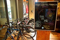
A blackboard at a Patagonia store in the Pearl District boasts that 68% of the staff’s commuting trips in March were by bicycle and 22% by bus, train or carpool. The store is housed in the EcoTrust Building, an 1895 brick landmark that’s been rehabbed since 1998 according to exacting green standards, from the garden on the roof to the weathered old floorboards. (Christopher Reynolds / LAT)

So I had a conversation with a DC transportation planning official on Saturday, and he said that the move in planning is from "mobility" to "accessibility." The Access to Destinations Study at the University of Minnesota defines the concept of accessibility thusly:

In the context of transportation studies, accessibility refers to the ability of people to reach the destinations they must visit in order to meet their needs, and desire to visit to satisfy their wants.

With that in mind, we should rethink the The Transit Metropolis of Cervero to the Mobility-Accessibility metropolis. (One of the problems with referring to accessibility is that people often think this concerns place access issues of the disabled.) In any case, the concept I have of the mobilityshed, and Bremen's Mobil Punkt -- mobility hubs, are part of the solution, overlaid with the idea of the Walkable community (see Dan Burden's article, "How Can I Find and Help Build a Walkable Community?").

As Ford Motor puts it in a press release, "FORD, UNIVERSITY OF MICHIGAN DEVELOP NEW MOBILITY AND TRANSPORTATION OPTIONS FOR THE FUTURE":

Working with U-M’s Sustainable Mobility and Accessibility Research and Transformation (SMART) program and local-market partners, Ford is developing “Ford Urban Mobility Networks.” The new program is designed to efficiently connect individuals to a variety of transportation options – buses, trains, taxis, car-share fleets, mopeds and bicycles – in urban areas where population growth is beginning to affect access to affordable personal mobility.

These transportation options are available through a transfer point or ‘hub’ where various modes of transportation and services come together. The hubs can be simple places where two modes of transport meet or they can be elaborate with many transport modes, along with services offering commuters information on entertainment, recreation, dining, banking, commerce, community services and more. The network of hubs is enhanced by information technology that provides real-time travel and schedule information, either at kiosks or through a personal communication device such as a mobile phone. A network of hubs throughout a city is connected to provide commuters convenient, safe and affordable trips.

From the mobilityshed standpoint, a hub is transit station or route, and hubs are planned to support multiple modes and build agglomeration benefits for accessibility. For example, the Fort Totten Metro Station has a big taxi stand, and of course serves as a transfer point from walking and bus to the subway lines. There is a parking lot for commuters. And a number of stalls have carsharing vehicles. Should better accommodations for bicycling be in the mix? Etc.

To get there, read "L.A. could learn a thing or two from Portland" from the Los Angeles Times and "Portland is a hub for the car-free and carefree" from USA Today, about Portland, Oregon.
Portland, Oregon - latimes.com.jpg
Finding an alternative to driving, commuters on bicycles pump toward downtown Portland, Ore., as a bus trundles alongside. In a town whose solar-powered parking meters bespeak a green mind-set, another incentive to ditch the car is a convenient streetcar line that links downtown and several inviting neighborhoods. Useful for residents and tourists alike, it the streetcar system costs a mere $1.70 to ride all day — or nothing if you stick to downtown’s “fareless square” — and complements a regional commuter train called MAX. (Dana E. Olsen / The Oregonian)

DC works better for transit than Portland. Far more people ride transit within DC and the region. (The DC region is larger than Portland's, while DC and Portland are about the same size.) However, Portland is better on three very important dimensions:

1. Linking land use planning to transportation planning.
2. Planning "more" equally for transit, bicycling, and walking when compared to most places where the car is the dominant form of transportation, and is the object around which most land use and transportation planning is focused.
3. The urban growth boundary (which to some extent--not enough--keeps in check some of the problems of sprawl).

Labels: , ,

Monday, September 03, 2007

Will and development and transit and transit oriented development and compact development and sprawl and...

Yesterday's Post has a somewhat critical piece about WMATA and its land development policies and practices adjacent to Metro stations. See "Metro Fails To Nurture Development, Report Finds."

(Click here for the actual report: Report of the Joint Development Task Force to the Washington Metropolitan Area Transit Authority.)

I think this is a complicated situation.

1. The WMATA system is mostly a transit system that owns some land. There isn't an internal commitment to dealing with this. Even though in other countries, such as Hong Kong, aggressive land development generates up to 50% of the transit system's revenue.

2. There isn't a solid regional understanding about the links between compact development, mixed use development, density, and successful transit--even within DC proper, which is the most compactly developed community within the region.

3. Because WMATA is a public agency there are public participation processes and most area residents advocate against density around their stations. Sometimes this is a good thing, because the proposals aren't very good--meaning they should be denser. But a lot of the time, this means that piddling proposals go through. (This is different with the Fort Totten Station.) In any case, getting projects through takes a long long time. And the article compares office-oriented districts around stations to non-office oriented districts around stations, which isn't a like comparison.

Remember how Congressmen Davis (Virginia) and Wynn (Maryland) put riders on funding for WMATA that restricted specific development projects for areas within their districts? WMATA has to deal with this kind of stuff all the time, and it has to keep Congressmen happy, because they are important stakeholders in the process.

Years ago, residents fought off a not very dense project by the Tenleytown Station. Years ago, Brookland residents fought off a not very dense rowhouse project by Brookland Station. (WRT the latter, as a result a more dense development will end up happening.) Takoma Park residents too continue to advocate against development around the station.

One of the problems is that the regional transit system in Washington promotes sprawl. (See Belmont's Cities in Full.) And the reality is that transit oriented development is the historic urban form in DC and the inner ring suburbs--transit oriented development typifies areas within center cities built before 1920--but that people forgot this fact.

4. DC's report, Trans-Formation: Recreating Transit-Oriented Neighborhood Centers in Washington, DC, is an excellent discussion of why compact development linked to transit is a good thing. But we don't need to call it TOD--it's merely good planning practice to strengthen and extend the urban-transit-friendly development form within DC.

5. WMATA's 2005 report on development around subway stations (Development Related Ridership Survey) finds that in the Central Business District, 75% of office trips (commuters) and 56% of residential trips are taken on transit (mostly subway but also bus). Inside the Beltway, the figures are 30% for office trips and 49% for residential trips (I would like to look at the data within the city, and within the area that I call the monocentric subway core within DC). Outside the Beltway, 11% of office commutes are by transit, and 32% of non-work trips by residents.

The point is clear that development by subway stations doesn't increase automobile traffic all that much--which is the major complaint and concern by residents in advance of such development.

6. Any type of development project involving government-owned land takes a long long long time. And any evaluation report of such processes at virtually any jurisdiction in this region would come up with similar findings, not that I am trying to let WMATA off the hook.

See "Forty Years of Growth, Except Where It Was Expected," from the New York Times.

Also see this blog entry which proposed a denser multiunit residential building adjacent to the Takoma Metro Station, rather than rowhouses. Further this testimony proposes providing no parking.

7. Note that the Neighborhood Business District Strategy for Seattle creates zones around light rail stations where there are no minimum parking requirements.

Labels: , ,

Saturday, September 01, 2007

More faulty comparisons

14th Street NW, 1959
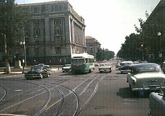
Constitution Avenue? around 14th Street NW, 1959. Photo from Dave's Railpix.

Earlier in the week I wrote about some bad data analysis in the Examiner. It was a story about poverty statistics from the Census. First, it compared DC, a city, to states. On that basis, DC is the most impoverished state in the country. But when you compare DC to other center cities, it's not anywhere near the top 10.

Second, the story compared blacks and whites on a gross basis, even though to be fair, this has to be considered by income tranche.

Anyway....

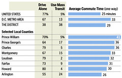
Sam Staley of the Reason Foundation (a pro-sprawl libertarian organization) has an op-ed in the Examiner, "Transit passengers face longer commutes than drivers," that makes the point that drivers in the Washington region have shorter commutes than transit riders. But as the Post reported earlier in the year, commuters in Washington DC and Arlington have commuting times at or around the national average. (Speaking of incorrect data analysis, this doesn't exactly answer the point that Staley raises...)
Daily Misery Has a Number Commute 2nd-Longest in U.S.
Post Graphic. Census data.

The point really is that you have to look at this at the micro-level of jurisdiction. For transit to be efficient, it works best in a compact development scenario. I ride a bike to work, and it takes me less than 15 minutes to get to work. (More if I stop to pick up trash on the way...)

But how people get to work isn't always just about the commute. I can't imagine driving in traffic to and from work every day--even for 26 minutes...
Graphic in the Washington Post about commuting behavior in the region
DC's population is increasing, but the number of people who get to work by driving alone has decreased significantly. Image from the Washington Post.

The issue is really about what transportation researchers call "accessibility," or the proximity and density of destinations. If a place has more desireable places in close proximity, then you spend less time travelling between them. That's the whole point of compact and mixed use development.

So what if it takes people from Loudoun or Spotsylvania Counties a long time to get to work. They made their choices. As did I. I can bike to work, to school, to meetings, to the grocery store, etc. Now I can't carry as much (e.g., I have to figure out how to transport a case of bottled beer on my bike--or do I take the bus?). It's all about choice, isn't it, which is what the libertarians would say anyway. We are just advocating for the viable choice of the compactly developed, mixed use, non-automobile centric center city.

Another issue of course is the jobs-housing balance. From the standpoint of the center city, we need to build the skills level of DC residents so that more people within the city can work in the city, and won't have to travel too far outside the city for work, further reducing commuting times, and increasing the likelihood of transit use.
14th Street NW in the evening
14th Street NW in the evening. This is not the way for me...

Labels: , , , , ,

Monday, August 20, 2007

Missing the point about the cost of commuting

It's about the development form. Is it any wonder that places like Houston--no zoning, sprawl--and Detroit--the city where an automobile industry based on mass production was created, and the region was re-created around deconcentration, and where mass transportation was junked, "logically," in favor of the automobile--the cost of getting around--transportation--is high, and separate, rather than chained, trips are required to accomplish most tasks. Without "centers" non-automobile based transportation systems are difficult to pull off.

Note that it is interesting that the Dallas light rail system is considered a great success, whereas 5 of the bus lines in DC proper carry about 75% of the equivalent ridership, which is a function of density of housing, and density of destinations.

See "America's Most Expensive Commutes," from Forbes Magazine, which lists the top ten cities where households spend the most dollars on transportation.

---------
Ironically, to get to the article, I had to avoid a screen ad from Jeep, and there is some kind of fancy ad from Audi within the piece also.

For an alternative view about how to make commuting better, see this past entry from Washcycle, Biking to work = happiness.

I saw a relatively large number of bikes in Brooklyn this weekend, depending on the area where I happened to be. We stayed at a place about two blocks from a Q line station, and one half block from Coney Island Avenue, which has 24 hour bus service, and for large parts of the day, bus service headways range from 7 to 12 minutes. And with a $7 all day pass, you can get on and off and on again without worry about spending too much money. (The weekly transit pass is a steal at $24. Of course, the 30 day pass is even better: $76.)

And on one subway platform I managed to explain to someone who asked me how to get to Yankee Stadium that he needed to be going "uptown".

All the buses in Brooklyn have a borough bus map posted. Metrobuses have the space for such maps, but they don't utilize the space thusly.

Labels: , , ,

Thursday, August 16, 2007

The Skoda Streetcar (in Portland) is 66 feet long

Streetcar and Bike, 10th and Washington,Portland
Streetcar and Bike, 10th and Washington, Miles Hochstein, Portland Ground.

and can move 30 people seated and 127 standing.

66 feet of roadway can accommodate about 4 cars, carrying typically no more than 2 people each. (Note that the Mini, a "small" car, is 12 feet long.)

Which is more efficient and effective use of the vital streetspace that Len Sullivan cares for so deeply?

Also see, in terms of utilizing rights of way, "Rapid Streetcar:Rescaling Design and Cost for More Affordable Light Rail Transit," from Light Rail Now.

See for yourself. If you can't go to Portland, at the very least you can look at Portland Streetcar photos on Flickr.

Labels: , , , ,

Len Sullivan lives in Bethesda and advocates for automobility

while he does some great work with his NARPAC organization, his position is determined in large part by where he lives and how he gets around.

So why does Channel 4 use him as a primary source of opposition to enhancing mobility within DC through the introduction of streetcars?

See ""Cars To Come Back To D.C. Not Everyone Happy To See Street Cars Come Back."

I love one of his comments about streetcars on K Street--"pedestrians are a nuisance"-- from one of his reports. See below, from the 1/14/2004 issue of themail:

Is NARPAC Really a Commuter Lobby?
Richard Layman, Northeast DC

Until recently, I had always been impressed by the reportage and analysis of Len Sullivan-NARPAC. However, I was troubled by a recent post (themail, January 4, “New Year’s Notion for Commuters to DC”) that I felt was unduly critical of DC residents. In the January 7 issue of themail, NARPAC announces an analysis of the proposed K Street busway. A number of the statements in the report are troubling. One section is entitled: “Pedestrians are a major nuisance.” Another statement is “Sidewalks are now used inefficiently due to the narrowing caused by curbside trees with their root grates, etc.” And “Lost parking must be accommodated (and expanded) somewhere. It is essential to get people out of their cars downtown, but not by trying to get Americans to give up their second most desired possession.”

On the latter point, I will say that the public space was not originally created to provide parking for personally-owned vehicles. Parking is a privilege, not a right, and providing parking spaces isn't the primary development priority that suburbanites believe we should take up. (Jane Jacobs would say something like, “You are asking the wrong question. The question isn't 'why aren't there more parking spaces?' The real question is 'why are there so many cars?', or 'why do so many people want to drive knowing there aren't more parking spaces?'”)

To truly be a transit city, we must constantly improve and expand transit systems. It is encouraging to see the various initiatives of the DC Department of Transportation to do so, such as via the proposed K Street busway. Another is to encourage the use of transit by making less preferred modes more difficult and expensive to use. Providing maximum parking tears at the urban fabric and streetscape without encouraging the use of transit. Parking tickets are a “positive” disincentive that ought to encourage “rational economic-thinking” people to use other modes of transit. Instead, people blame the ticketer or the situation, instead of their decision to drive and park (perhaps illegally) in the first place. This relates to a serious concern faced by DC's advocates for a “livable city.”

The US is dominated by an automobile-centric planning and development paradigm. Most every person in the region, including those who live in the city, has been imprinted with that paradigm without realizing that it is but one choice. Just one example is that there are plenty of people who think the solution to revitalization of our neighborhood commercial districts is in the demolition of the adjoining residential neighborhoods in favor of parking.

I fall into the trap of arguing with people about this lunacy, rather than just walking away ruing the fact that they've never read Jane Jacobs Death and Life of Great American Cities. The “teachable moment” so often when the entire worldview of the “student” is shaped by the automobile. It is troubling that forty-two years after the publication of that book, people who allegedly care about the city think that planning for the pedestrian and focusing on urban design and the streetscape is a “nuisance” and that we should be focused on making life simple and free for car drivers.

Labels: , , , , ,

Tuesday, August 14, 2007

Speaking of balancing transportation modes and transportation demand management planning

From Time Magazine, a story I missed, about accommodating bicyclists through "valet parking." See "How Valet Parking Could Save the Planet."

Hmm, can shared retail district-provided delivery services be far behind?

In the context of the bike rental service from Adshel that will be rolled out in DC, they said that they are focusing on downtown in terms of locating centers. Likely, one will be at Union Station. So I have suggested planning locations around trip times. Logically, it would be worth having a rental location at the Eastern Market Metro Plaza, which would be a 15 minute or so bike ride from Union Station...

And I will repeat the suggestion that the Downtown YWCA and Rhode Island Avenue YMCA and the DC JCC could create special club memberships for bicyclist-commuters.

Labels: , , , , ,

Friday, July 27, 2007

More on bike sharing

The amazing trend watching website Springwise has some great pieces on this:

-- City bike schemes
-- Bank-sponsored bike sharing
-- City bike schemes — Update from Paris

Labels: , , ,

An idea for free public transit within DC

Alan sends a link to this article, Fare-Free Public Transit Could Be Headed to a City Near You. He writes:

Why can't a variation of this be done here in the nation's capital? The loss in revenue could be offset with either (a) an increase in thesales tax (b) re-routing a sizable portion of parking fine and parking meter revenue to the public transit system (thereby allowing drivers to subsidize riders) (c) increasing parking meter costs (either by decreasing the time that money can buy or increasing the cost per "x number of minutes" (15?) increment). I'm sure alternate financing schemes could also be discussed but these seem least likely to run afoul of Congress.

My response:

This idea is in my big transportation paper, which I have to rewrite before I am willing to send it around. There are a couple issues. First I propose a transit withholding tax as done in certain parts of Oregon. Depending on the rate, that could generate about $200 million/year.

Second, the cost of providing free surface transportation within DC (for various reasons it's too difficult to try to do this underground, not mechanically, but because how the system is funded) would be about $80 million/year more beyond the current subsidy (that is based on my estimate of revenue from farebox). It will go up as streetcar service is added.

Third, you have to figure out if you get that much value for the $80 mil. I say no. That it is more important to spend that kind of money on creating the separate blue line subway from Arlington through Georgetown and the center city, to provide redundancy and added capacity.

Four, however, and this is for the revision because I only figured this out the next day after I finished the paper, the thing to do is make intra-neighborhood transit free.

I propose three service levels of public transit (and this is merely an extension of the structure laid out in Arlington's Transportation Plan, Transit Element 2nd Draft, plus thinking about BART versus and vis-a-vis the intra-San Francisco MUNI system), primary, railroad, subway, major bus lines that are intra-regional, secondary, high capacity transit that is primarily intra-city with regional connectivity, and tertiary, which could be high-utility intra-neighborhood transit services which could take people to and from commercial districts and shopping places, and include delivery, and take people to bus, streetcar, and subway transfer points, and would be more jitney like, at night would drop people off anywhere within the route area, etc. This would also get people to subway stations without their having to drive.

I think that this kind of transit service is worth providing for free. I haven't estimated the cost, but it would be a lot, could be up to $30 mil./year or even more. But it would allow for car-free living, or at least vastly reduce the need for a car for intra-city mobilty.
-------
Rob Goodspeed writes about jitney-like bus service in Cape Town, South Africa in the blog entry "The Minibus Solution," and he mentions a tome which looks to be pretty interesting. Rob writes:

Like a train system (which Cape Town also has), the buses run along fixed routes named after their final destination. Each bus is a small Toyota van with customized seats designed to maximize the vehicle’s occupancy.... The vans will stop to pick up or let off passengers at any point on their route, although bus stops and major landmarks like the supermarket are common points. The routes terminate at government-built transit depots. ...

Two South African urban scholars have recently examined urban transport in that country in a text titled Rethinking Urban Transport After Modernism: Lessons from South Africa. Although the book is expensive to purchase in the states, Google Books has a preview with many pages from it. They conclude that current public transportation systems are not sustainable and urge a paradigm shift in the way transport is conceived, including:

- creating a decentralized pattern of accessibility to decentralize opportunity in the city (versus the modern, radial model centered on a downtown)
- create pedestrian friendly environments
- link transport to high densities of housing and land use- design complete streets with a full range of uses in mind, not simply roads for cars
- and link transportation planning with urban design and urban planning.
------
Whereas I am not sure that I fully agree that it is sustainable to have "1,000 flowers bloom," with a focus on decentralization, especially given the arguments for recentralization of housing, commerce, and transit is proposed in Cities in Full, the ideas dovetail with this idea of creating high-value transit service within neighborhoods, recognizing the need for a rebalancing between the center of the city and neighborhoods, just as we propose a rebalancing towards walkability, bikability, and transit whereas the mobility system today is overfocused on serving automobility.

Rob writes about the cost structure in South Africa being much lower (and this is true of South America too, where many public transit systems have buses run by the driver-operators), but the idea of that kind of intra-neighborhood transit can work in DC neighborhoods as most places within neighborhoods are located within one mile of major transit service, either high-frequency and high-use bus lines or the subway, and eventually the streetcar.

NOTE THAT EVEN I GET BORED WRITING ABOUT TRANSIT ALL THE TIME, it's just that urban form, healthy neighborhoods, successful commercial districts, and efficient transit are intertwined.

Such are the "technologies" that make center cities successful, vibrant, and competitive for the 21st century.

Labels: , , , , ,

How walkable is your neighborhood?

WalkScore will calculate it for you, based on data in GoogleMaps. Dupont Circle scores 100. Capitol Hill 91, Brookland in the mid to high 60s and low 70s. There are defects in the scoring model, see How It Doesn't Work, but overall it works pretty well:

Your WalkScore is a number between 0 and 100. The walkability of an address depends on how far you are comfortable walking—after all, everything is within walking distance if you have the time. Here are general guidelines for interpreting your score:

90 - 100 = Walkers' Paradise: Most errands can be accomplished on foot and many people get by without owning a car.
70 - 90 = Very Walkable: It's possible to get by without owning a car.
50 - 70 = Some Walkable Locations: Some stores and amenities are within walking distance, but many everyday trips still require a car.
25 - 50 = Not Walkable: Only a few destinations are within easy walking range. For most errands, driving is a must.
0 - 25 = Driving Only: Virtually no neighborhood destinations within walking range. You can walk from your house to your car!

From Walkable Neighborhoods on the WalkScore website:

Picture a walkable neighborhood. You lose weight each time you walk to the grocery store. You stroll home from last call without waiting for a cab. You spend less money on your car—or you don't own a car. When you shop, you support your local economy. You talk to your neighbors.
What makes a neighborhood walkable?


Walkable communities tend to have the following characteristics:

A center: Walkable neighborhoods have a discernable center, whether it's a shopping district, a main street, or a public space.

Density: The neighborhood is compact, rather than spread out, which brings people closer to stores and jobs and makes public transportation more cost effective.

Mixed income, mixed use: Housing is provided for everyone who works in the neighborhood: young and old, singles and families, rich and poor. Businesses and residences are located near each other.

Parks and public space: There are plenty of public places to gather and play.

Accessibility: The neighborhood is accessible to everyone and has wheelchair access, plenty of benches with shade, sidewalks on all streets, etc.

Well connected, speed controlled streets: Streets form a connected grid that improves traffic by providing many routes to any destination. Streets are narrow to control speed, and shaded by trees to protect pedestrians.

Pedestrian-centric design: Buildings are placed close to the street to cater to foot traffic, with parking lots relegated to the back.

Close schools and workplaces: Schools and workplaces are close enough that most residents can walk from their homes.

Labels: , , , , ,

Wednesday, July 25, 2007

Streetcar more than a nostalgic toy

DC Streetcar being tested in Europe
DC Streetcar being tested in Europe. Image from the Center City Action Agenda April presentation, part 2.

This letter to the editor, by Ralph Garboushian, Transportation Committee chair, D.C. Chapter of the Sierra Club, appeared in yesterday's Examiner:

Re: “New Orleans’ trolley cars used to be main option,” July 18

We were pleased to see Steve Eldridge’s recent article about one of the most efficient, comfortable, urbane and civilized forms of transportation: the streetcar. However, we wish Eldridge had examined the streetcar systems of cities other than New Orleans — a devastated city that has lost half of its population, is struggling economically and has seen its streetcar network considerably scaled back.

Eldridge should travel to vibrant and bustling Toronto, which rather than abandon its streetcar system after World War II, modernized and expanded it at the same time it built a subway system.

Or Portland, Ore., which recently built a downtown streetcar line to complement its regional light rail system. Portland’s downtown is the envy of most U.S. cities and the streetcar is directly responsible for the redevelopment of a nearby warehouse district.

Or Melbourne, Australia, which like Toronto expanded and modernized its streetcar system and now boasts one of the world’s largest. Melbourne’s streetcars are beloved by its citizens, and Melbourne is regularly rated as Australia’s most beautiful and livable city. Indeed, cities with robust streetcars share the distinction of regularly landing at or near the top of lists of the world’s most livable cities.

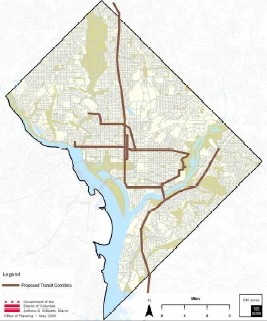
The District’s proposal for a 40- to 50-mile streetcar network would be much more than a nostalgic toy for moving tourists. It would improve transit service along several key corridors that suffer from overcrowded and unreliable bus service, some of the longest transit travel times to employment centers in the city and have yet to benefit from the revitalization that Metrorail has brought to other District corridors.

Indeed, the primary goal of the proposed streetcar network is to improve mobility within the District. While our valuable Metrorail system does an excellent job of moving people around the region and especially from the suburbs to the District, it does not serve or connect many District neighborhoods.

Streetcars played an integral role in the District’s transportation history. From the turn of the century through WWII, streetcars were the primary mode of transportation for most Washingtonians and played a major role in the development of many D.C. neighborhoods. The abandonment of the District’s streetcar system in 1962 was a major mistake that accelerated the decline of many neighborhoods and contributed to the clogged streets and foul air we now grapple with daily.

Our current political leaders often talk about making Washington a world-class city and attracting 100,000 new residents. The District’s plan for a 40- to 50-mile streetcar network gives it the historic opportunity to correct the tragic mistake of their unelected 1962 counterparts and put Washington firmly on the path toward becoming a world-class city — and attracting 100,000 new residents without the nightmare of 100,000 new cars.

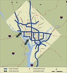
DC Streetcar Map as depicted in the Comprehensive Plan draft revision
Proposed DC Streetcar Map as depicted in the Comprehensive Plan draft revision

Proposed streetcar lines, DC
Proposed streetcar lines according to the original DC Transit Future study.

Labels: , , ,

Friday, July 06, 2007

Milford man wages court challenge of speed limits

(Speaking of my constant point about the engineering of roads and automobiles allowing "comfortable" speeds that are far beyond that which is safe for pedestrians, bicyclists, and creating community and foot-based retail.)

The New Hampshire Union Leader reports, in "Milford man wages court challenge of speed limits," that:

Larry Lemay likes to drive at a speed he considers "comfortable." Unfortunately for him, comfortable is often well above the posted speed limit. He's gotten four speeding tickets so far this year alone. But rather than slowing down to spare his wallet, Lemay is fighting to allow faster driving.

The Milford man is suing in Strafford County Superior Court to force the state Department of Transportation to conduct traffic studies and reevaluate speed limits across the state, per federal standards, in a move he believes would lead to faster, and safer, driving.

But Assistant Attorney General Dave Hilts, who is handling the case for the state, dismissed Lemay's argument, saying he's been indoctrinated by speed limit abolitionists who claim higher limits are better. They spread their gospel over the web, Hilts said.

"Common sense will tell you that going too slow is only a hazard when other people are going much faster," he said. "It's kind of a weird case." Hilts said Lemay has used legal language and cited cases from internet speed limit abolitionists in past and present cases. Lemay himself admits to using the internet to build his case and readily cites similar legal challenges in other states.

Labels: , , , ,

Tuesday, June 05, 2007

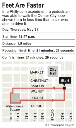
Pedestrians faster than cars in Center City Philadelphia

According to "Heart of Phila. near standstill," subtitled "Center City’s clogged arteries," from the Philadelphia Inquirer. The pedestrian beat out the car by a couple minutes. Plus it's easier and cheaper "to park" although Philly has a godawful number of surface parking lots.

A bike would be even faster.

Now, I say that congestion isn't that bad in Downtown DC, but there is no question that roads like K and I Streets, 14th, New York and Florida Avenues in NE and NW, Wisconsin Avenue, especially in Friendship Heights, M Street NW, etc., are quite congested for key periods during the day and into the early evening. However, later, most streets are pretty dead.
Walking vs. Driving in Philadelphia

Labels: ,

Tuesday, May 29, 2007

Bike sharing blog

One of my favorite and only must-read blogs in the area, Washcycle, calls our attention to Arlington's Paul DeMaio and his blog on bike sharing systems and projects. Paul has a consultancy focusing on this area. I've added a link to this blog in the right sidebar.

1. DC is implementing a system through Adshel.
2. We need to get WMATA to do the same thing.
3. Maybe Amtrak could do this at Penn Station in Baltimore (since DC is doing a Bike Station at Union Station in DC already).
4. And the other jurisdictions in certain urban places -- i.e., Montgomery at least in Bethesda and Silver Spring.
5. Plus Baltimore...

I think that one of the problems of government agencies is that they don't work to pursue multiple simultaneous objectives when creating such systems. One logical market segment of interest is tourists. Even in-region visitors. For example, I could go to Baltimore for the day and just do bike sharing for the day, rather than schlep my bike back and forth between the regions.

Labels: , , ,

Bike Arlington this Sunday, June 3rd

----------
This entry was originally written in March, and titled "Organized Community and/or Neighborhood Bicycle Rides." I now feel even more strongly that this needs to be done throughout DC neighborhoods. I hope to pull one of these off for Brookland next year.

I will be out of town this weekend, otherwise I probably would attend this Sunday's Bike Arlington and Alexandria extravaganza.
-----------------

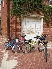
Bicycles, Brown's Court
Do we have such in DC? Shouldn't we do this within various neighborhoods as a way to promote greater bicycle usage?

From "I wanna bike," by Diana Sun, Communications Director for Arlington County, in the CommuterPage Blog:

My husband and I rode in Arlington's Community Bike Ride last year, and had a great time. Through the Ride, I learned how bike-friendly it is in our community. And the range of sights! Everything from tree-covered trails to that gorgeous view along the Potomac to the marked bike lanes in "downtown" Ballston. (The Arlington Community Bike Ride is June 3rd this year -- mark your calendar!)

Not sure yet if I'll sign up just to experience it, but maybe...

This is something we need to do. Separately, I realized (and wrote) that all neighborhood commercial districts probably should create bike tours (downloadable) for their districts. And it's now on my list of things to get done for the Brookland Main Street program.

Note to David of Washcycle, I've been thinking this is the kind of thing that can be done jointly with a blog like yours and the Washington Area Bicyclist Association. (The Brookland Community Development Corporation is already involved with WABA and the Metropolitan Branch Trail--I haven't been party to those activities and hard work over the past many years.)

Also check out Arlington's Bike Arlington program, and DC's Department of Transportation Bicycle Program webpage.
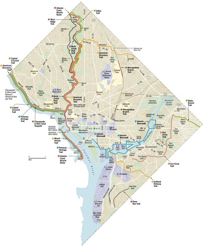
DC Bicycle trails
DC Bicycle trails. Washington Post graphic. Click through for a larger version.

Labels: , , , ,

An addendum on bicycling in Europe and USA--is there a sociology of biking in the city?

(This is a reprint of a post from an e-list by Professor John Gilderbloom of the University of Louisville.)

Here is an effort to answer to her question on Amsterdam biking, the residents do not share the road but have separate bike and car lanes. As a person who still bikes, Amsterdam is our Nirvana (without the Kurt Cobain). It's also an integrated part of the tourism industry--folks go there to ride bikes since it is so unsafe in so many U.S. cities althought the exceptions would be Davis and Santa Barbara (I rode my bike their exlusively for 8 out of 10 years there) and in terms of big cities Portland and Chicago might be among the best places.

More interesting is that the historic part of Amsterdam is less accessible by car encouraging folks to either walk or ride bikes (some progressives are pushing historic Amsterdam to eventually be car free but that is unlikely because of the infrastructure of existing car garages and parking spaces).

In terms of dress, the Dutch use bikes not only to go to work but to go out at night to clubs or shop. Yes, you will see women in short skirts (even micro ones!) and dresses peddling along as well as men dressed dressed in a suit and tie.

More interesting is that virtually nobody wears a bike helmet in Holland (unless they are on a competititve bike team) which is a sign of safety for riders--as John Pucher see attached post below) notes in his research the odds of a serious injury on a bike is far less than riding in a car. More interesting is that 4 out of 5 folks in Amsterdam use a bike or walk to commute from home to work.

Another number of interest is that for every citizen of Amsterdam you have two bikes. The Dutch embrace biking in terms of getting to work as a more efficient and economical way--no gas needed, environmental reasons, parking closer to the office, health benefits both physical and mental (see below on John Pucher), affordable and safer.

Biking is safer in places like Amsterdam because bike safety is taught early in grade school, discussed in the media and bikes are required to have safety equipment along with bike fins to prevent mud from being splashed on others. The bikes are built for comfort and crusing not for racing. While the percentage of the Dutch elderly riding bikes falls somewhat, you still see many of them still riding bikes throughout Amsterdam as well.

Even the elite ride bikes including members of the royal family. When I take my graduate students to Holland, they must go car free by walking, biking or using the tram. The entire
experience of just 10 days in Holland has radicalized many students to being pro bike.

So who doesn't bike? Many immigrants from Muslim countries do not embrace biking from their country of origin. It's also another sign of the lack of integraton and separation of many Muslims into Amsterdam (certain stores only advertise goods in Arabic language only). But the Dutch are trying to encourage more biking by Muslims by offering workshops on how to ride bikes and be safe. If you really want to embrace the "sociology of biking" I would urge folks to watch the powerpont presentation made by John Pucher of Rutgers when he visited us earlier this year.

Several weeks ago I posted a message on several listserves on the the great work of Rutgers University Professor John Pucher who has mustered up the empirical data showing the following: urban residents who walk or ride bikes because of the installation of bike lanes gain an extra hour of life for every hour of biking or on average biking culture can increase the lifespan of a person from two to four years in Holland and Germany. It's pretty amazing stuff. That would seem like headline news yet it gets very little mention here. Moroever, the state saves on health cost payouts because folks are healthier.

I think he also noted that folks who ride bike tend to be smarter and happier--I am sure a sociologists will also come out with a finding that sex lives are better as well which will result in an explosion of biking. Finally, Professor Pucher also notes that we save money on commute times, give less money to countires that REALLY hate us, and we pollute the environment less. Here is the web address of getting the powerpoint and his ideas form his Louisville talk. It's great stuff: and here is how to see it:


Professor John Pucher's webpage -- scroll down to the Recent Publications section (where you can access PDF files of about 10 or so articles) and then a bit further, to the Powerpoints posted just below that.

Labels: , , ,