Rebuilding Place in the Urban Space

"A community’s physical form, rather than its land uses, is its most intrinsic and enduring characteristic." [Katz, EPA] This blog focuses on place and placemaking and all that makes it work--historic preservation, urban design, transportation, asset-based community development, arts & cultural development, commercial district revitalization, tourism & destination development, and quality of life advocacy--along with doses of civic engagement and good governance watchdogging.

Wednesday, April 17, 2013

Ultimately, WMATA blue line riders have been dissed by the State of Virginia, not WMATA...

... because the Silver Line extension was built with no consideration for its impact on the core of the system.

I am reminded that "no one" seems to talk about this because of an opinion piece ("Metro kicks Blue Line riders to the curb") and a letter to the editor ("Blue Line riders facing double jeopardy") published in response, both in the Washington Post last week.

From the first piece:

I count on Metro to get me to work. But lately Metro isn’t holding up its end of the bargain.

Last June, Metro launched “Rush Plus,” which took resources away from the Blue Line and gave them to the Yellow Line. During the peak morning hours, there are now three Yellow Line trains for every one on the Blue Line. This holds true for the commute home as well: three Orange Line trains for every Blue.

For thousands of daily Blue Line riders, the change meant that the commute downtown and back suddenly got much longer. Now, when a Blue Line train finally arrives, it’s as crowded as Chinatown the night of a Caps game. Sure, Metro encourages Blue Line riders to take the Yellow Line and transfer, but this just adds insult to injury for many of us: The route makes little sense for downtown workers and adds time to the already-lengthy commute.

Now Metro is laying the groundwork for opening the Silver Line near the end of the year. It recently told riders that “when the Silver Line opens, in order to create more space in the Rosslyn tunnel, Blue Line trains, all day long, will run 12 minutes apart.” Metro’s answer to concerned Blue Line users? Take a bus. ...

Between Rush Plus and the impending 12-minute waits for packed trains, this redistribution of resources is pushing Blue Line riders out of the rail system — and into their cars.

Lack of capacity at the Rosslyn tunnel

It's lack of capacity at the Rosslyn tunnel crossing to DC that prevents full running of the Silver, Orange, and Blue lines into DC from that point.

That's why the so-called Rush Plus routing was created, to divert a bunch of blue line trains to WMATA's "southern" crossing of the Potomac River, the Yellow Line bridge crossing.

Since 2000, there have been capacity issues in Rosslyn in terms of the tunnel crossing into Washington.  The Orange Line is highly used, and the Blue Line's normal routing uses the same tunnel.  The time it takes to turn the switch from one line to the other limits capacity if shared equally to about 26 trains per hour.

By changing the mix to 2/3 Orange Line trains and 1/3 Blue Line trains, throughput capacity of the tunnel was increased some.

The Silver Line opening puts more demand on the Rosslyn tunnel

That's why WMATA is further reducing use of the Rosslyn tunnel by the blue line.

Why this is happening

1.  In 2003, in mostly a budget move but with some political mojo as well*, WMATA devolved responsibility for expansion planning to the separate jurisdictions.  (* Re the political move: face it, getting local approvals--see all the whining about the proposed Purple Line in Chevy Chase--is time consuming and fraught with peril, so giving this responsibility to the separate jurisdictions does make sense on that element.)

2.  Metro expansion planning by the jurisdictions fails to take responsibility for impact on the existing system and does not add infrastructure and capacity if needed as a result of the changes.

Note that this is still a problem as presented by proposals for WMATA extensions further into Virginia.

3.  And since the core of the system is in DC, unless DC were to raise and resolve the capacity issues that are created by extension, nothing would be done.

That's what happened with the Silver Line.
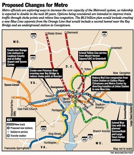
Proposed changes for the WMATA system, 2001 (separated blue line)
Proposed changes for the WMATA system, 2001 (separated blue line).  Washington Post graphic.

4.  The State of Virginia went ahead and is building the line without taking any responsibility for needing another tunnel crossing into Washington.  (Even though this piece of infrastructure was proposed in the Arlington County Transit Element of the County's Transportation Plan, as part of the so-called separated Blue Line.)

5.  And instead of responding, DC turned inward, focusing on streetcars almost exclusively, rather than push for admittedly very expensive improvements to the core of the Metro system (except for an initiative to improve throughput at Union Station).

You can understand DC's reticence on one level because improvements at the core are super expensive and also benefit the suburbs greatly, because suburban residents work in DC but their income tax revenues go to their home states.

But the reality is that maintaining DC's Central Business District as a preeminent location to locate business activity in the region is dependent on high quality, high capacity transit.

If the transit "fills up," then "more transit" needs to be added.

6.  DC should have used the creation of the Silver Line as the fulcrum for planning, designing, engineering, and constructing the so-called separated blue line--although it could now just be an extended silver line.

This would have added  more crossing capacity and warded off reaching capacity in the core of the Metro system in DC.  It would have added many more stations to the system including areas not served, such as Georgetown, and would have given Union Station--which is the busiest station in the system--another line serving it, doubling its capacity.

I suggested such action in a 2006 blog entry, "Blinking on urban design means you limit your chance for success," although the entry starts out by focusing more on the Silver Line and tunnel versus aerial routing, the latter half of the post discusses the crossing issue and the separated blue line.


Note that WMATA's Momentum long range plan does call for this sort of, but it will be 2040 before we see the results.

Instead, had DC acted earlier, we could be seeing the results starting this year and having finished it by the end of the decade.  (And it won't be til next year that limited streetcar service will begin.)

Devolving responsibility for transit expansion planning to the jurisdictions was a mistake

This is an illustration though of why devolving expansion planning responsibility to the separate jurisdictions was a mistake.  This is being rectified some by the current WMATA planning initiative, called Momentum.  But the basic problem persists.

Reducing transit service harms the relationship with people committed to sustainable mobility

And in the meantime, people complain about WMATA, like in the opinion piece published by the Post.  It goes on to say that WMATA has broken its compact with people to support a transit-centric/non-car dependent lifestyle.  From the piece:

Choosing a lifestyle that relies on Metro is a kind of compact, an unspoken agreement between the rider and the transit system. With the promise of a safe, accountable and relatively quick ride to work comes the burden of a higher cost of living in Metro-accessible areas. The rider accepts that braving the elements and a lack of personal space will become part of the commuting routine. She agrees to be part of the sustainable solution with a small carbon footprint that is a hallmark of policymakers’ long-term vision for the Washington area.

Making the commitment to purchase a home in a neighborhood with a Metro station cements this compact. Metro’s Blue Line cutbacks amount to a broken promise. Come autumn, I bet I won’t be the only Blue Line rider visiting a car dealership.

But is WMATA really at fault?

I would say that it's true that Virginians using the the Blue Line are being disserved, except that it's not just WMATA that has broken the compact.

It's the State of Virginia, it's DC--although impact on Blue Line riders in DC isn't really DC's main concern, so Arlington County has some responsibility too, Fairfax County too, because they prioritized service to Tysons Corner at the expense of other parts of the County, and it's the Transportation Policy Board of the Metropolitan Washington Council of Governments as all failed to address the problems that were going to result from changing one part of the system while taking no responsibility for the impact on other parts of the system.

The funny thing is that the hope that the political fallout dealing with transit expansion would fall away from WMATA by giving up responsibility for extension planning hasn't occurred because at the end of the day, WMATA runs the subway system and so WMATA is the most visible entity in all of this.

Instead, WMATA still takes the blame.

Labels: , ,

Friday, February 21, 2020

A "Transformational Projects Action Plan" for the Metrorail Blue Line

This piece is sparked by today's Post article, "Metro Blue Line extension into Prince William? Virginia lawmakers want a study," where Virginia legislators are looking to appropriate $2 million to study the extension of the Blue Line from Springfield in Fairfax County to Quantico in Prince William County.

Proposal:

1.  Go along with Virginia legislators desire to extend the Blue Line to Quantico, even though this is normally too long a distance for heavy rail.

In return for:

2.  Accelerating the creation of a second tunnel at Rosslyn crossing into DC; and

3.  Leveraging the project to create a Separated Blue Line in DC, resurrecting a long abandoned plan that was raised in 2001 and scuttled in 2003.  This would provide service to Georgetown and along M Street, another subway connection at Union Station, and service to H Street NE.

And doing it starting "now" not in 10 years...


Circa 2001 Metrorail expansion planning.  I have written many times of the old plan to build a "separated Blue Line" WMATA Metrorail line.

This would have created a second crossing under the Potomac River at Rosslyn and continued into Georgetown, perhaps along M Street to Union Station and then further east along H Street NE.

When this graphic accompanied a Washington Post article ("Crowds Could Derail Decades of Progress," 3/25/2001) about the proposal, just as a group of us were working on H Street revitalization matters, it was electrifying.
Proposed changes for the WMATA system, 2001 (separated blue line)

2003 Recession: WMATA drops expansion plans.  But in 2003, during a recessionary period for Greater Washington, WMATA dropped expansion planning in its entirety ("Metro Construction Projects Creak to Halt; Economic, Political Changes Cancel Expansion Plans, Spur Job Cuts, Early Retirements," Lyndsey Layton. Washington Post, July 13, 2003. pg. C.01), deferring responsibility for expansion planning to the separate jurisdictions.

Silver Line planning not affected.  Virginia continued on with its planning for the Silver Line, which it was pursuing separately anyway.  Insanely, they were allowed to do so without having to pay for capacity expansions in the core.  They said it wasn't their responsibility, even though the expansion would challenge system equilibrium.
Routing map, Silver Line WMATA

Washington DC didn't take the opportunity to leverage the Silver Line as the way to create a separated blue line.  Only Arlington kept hopes alive for a separated blue line in its Master Transportation Plan.

I started writing about the likely problems from this in 2006.

-- "The "Downtown" Circulator and Rosslyn, Virginia," 2006
-- "Blinking on urban design means you limit your chance for success," 2006
-- "Winners and losers with the Dulles subway project," 2007
-- "Silver Line Metro expansion a classic example of the need to have true regional transportation planning," 2011
-- "Ultimately, WMATA blue line riders have been dissed by the State of Virginia, not WMATA," 2013
-- "The Silver Line WMATA story that WJLA-TV missed," 2014

Ten years later, WMATA starts expansion planning again.  With evident problems forecast concerning capacity in the core, WMATA has refocused on expansion planning.  They've gone through a couple iterations, one the Momentum plan ("Metro proposes $26 billion overhaul," Post, 2013), including more recent releases which I haven't written about.

The major element of the newest plan is to add a crossing at Rosslyn, which they hope to do by 2030 ("Metro Looks At Building New Lines To Address Tunnel Congestion, But What’s Realistic?," WAMU/NPR).

I've never been pleased with this planning program, because it satisficed proposals based on what they could get all jurisdictions to agree to, rather than advocating for the best outcomes.  It adds capacity within the current footprint but nothing beyond it.

We all know how the Silver Line worked out: badly.  The subway lines had already been stressed by failures in the signalling system, culminating in the Fort Totten crash in 2009, which killed 9 people.  But the addition of the Silver Line made things worse, crashing the system overall.

-- "Redundancy, engineered resilience, and subway systems: Metrorail failures will increase without adding capacity in the core," 2016

Fantasy planning and the Paul Meissner maps.  The redundancy post made many arguments, including the problems that result from "inter-lining," which rather than containing problems when they occur, spreads them to other lines.  It called for making many changes to the Metrorail system, focused on separating the lines.  The main concept was a separated Silver Line, instead of a separated blue line.

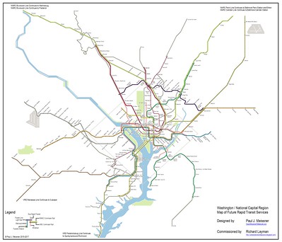
From that, I connected with a GGW reader and commenter, Paul Meissner, who agreed to create a couple maps, one showing the current rapid rail system, including railroad services, and an idealized fantasy map, based in part on previous plans and proposals.

Conceptual Future integrated rail transit service network for the Washington DC National Capitol Region. Design by Paul J. Meissner.  Concept by Richard Layman and Paul Meissner.

There was push and pull.  He was the graphic designer, which gave him  more say in the process (i.e., "possession is nine-tenths of the law") and output so the ideas were a mix from both of us and I had to compromise.

I've referenced the maps in a couple pieces, including:

-- "Setting the stage for the Purple Line light rail line to be an overwhelming success," 2017, a multi-part series
-- "Using the Silver Line as the priming event, what would a transit network improvement program look like for NoVA?," 2017

In the map development process, rather than suggesting an extension of the Blue Line, we proposed extending the Yellow Line, terminating at Fort Belvoir.  There, the idea was to capture and promote density along Route 1 and service to the military base, which was expanded as a part of the 2005 BRAC closure process.  To be frank, this should have happened as a result of that process, which I suggested back then.

A couple months after Paul finished the project, I realized we could have also proposed a separate Blue Line extension to Woodbridge and Dale City, not thinking about an extension as far as Quantico, which is almost 12 miles further.

Extension vs. intensification in transit planning. We need to distinguish between extending the system outward, or intensifying the system by adding capacity in the core, because these types of extensions have different impact. It's the type of expansion that matters, not expansion generally.

Adding capacity in the core improves reliability while extending service outward, especially without increasing core capacity, degrades service. Eliminating expansion in general limits the opportunity to improve system reliability.

Note that in some instances, system extension serves important purposes (e.g., such as to Fair Oaks in Fairfax County, extending the Orange Line, or to Fort Belvoir, which could be reached by extending the Yellow Line) but it shouldn't occur without simultaneously addressing how extension impacts the core system.

While normally I would argue that an extension of this length is nonsensical, it's worth considering if it can be leveraged to bring about the separated Blue Line in DC.

Transformational Projects Action Planning and the Blue Line.  TPAP is a concept I've developed which proposes to seed master plans with a set of anchor projects as the "transformational projects element" as a way to drive the plan forward in substantive, visionary, transformational, and beneficial ways ("A "Transformational Projects Action Plan" for a statewide passenger railroad program in Maryland" and "Why can't the "Bilbao Effect" be reproduced? | Bilbao as an example of Transformational Projects Action Planning").

I think that the Virginia legislative initiative ought to be leveraged to do three different things:

1.  Extend the Blue Line to Quantico (which will get support to do the two other elements).

2.  Add the second crossing at Rosslyn to Georgetown and the expanded transfer station.

3.  Create the separated Blue Line in DC, along the same lines as the original 2001 proposal, but with a couple twists.

-- The DC routing would add redundancy and capacity in the core, and provide a second subway connection to Union Station, which is necessary for support of railroad passenger expansion plans there.  At Mount Vernon Square it would provide another subway line connection to the proposed Maglev rail service.

-- It would add 8-10 new stations within DC, although the section between Georgetown and Mount Vernon Square is already pretty developed, so it wouldn't necessarily add a lot of new development capacity, which is the normal way to pay for the cost of such infrastructure expansions.

-- It would eliminate the need for a gondola transit connection between Rosslyn and Georgetown.

-- After Union Station the line should go out H Street, and then at Oklahoma Avenue, cross through the RFK campus, but underground, to RFK station and continue to the end of the line at Largo.

-- Undergrounding the lines here will add development capacity to the RFK campus.

-- The Orange/Silver Line would similarly go underground at RFK to pick up the current Orange Line routing from RFK to New Carrollton.

4.  This means no longer focusing on a separated Silver Line, but pairing the Silver and Orange Lines.  Frankly they could both be termed the Orange Line but with two branches.

-- Virginia should also consider an extension of the Orange Line from Vienna to Centreville as outlined in the Meissner map above.

5.  An extension of the Yellow Line to Fort Belvoir should also be studied as part of the planning, using a routing in the Route 1 Corridor.  Such a routing could extend from Fort Belvoir westward to connect to the Southern Blue Line extension.

-- if the Yellow Line were also to be extended, the addition of an infill Yellow Line station serving the National Mall in the vicinity of the Jefferson Memorial should be added to the program ("A National Mall-focused heritage (replica) streetcar service to serve visitors is a way bigger idea than a parking garage under the Mall").

Separated Blue Line or bust. Note that without the commitment to the second crossing and the Separated Blue Line in DC, I would argue that DC should vote against such an extension thereby dooming it to failure, since a unanimous vote is required.

Speaking of a unanimous vote, this program provides little additional benefit to Maryland.  Perhaps there is a way to do so.

Labels: , , , , ,

Saturday, March 28, 2026

WMATA's 50th anniversary from the start of service, Part 2b | Lessons learned: Proposed expansions and the Metrorail system we don't have

This is part of a series:

-- "Reprint with editing: Today WMATA Metrorail's 50th anniversary from the start of service | Part 1: many lessons can be found, if you look"
-- "WMATA's 50th anniversary from the start of service, Part 2a | The Original Approved Metrorail System (1968-1970)"
-- "WMATA's 50th anniversary from the start of service, Part 2b | Lessons learned: Proposed expansions and the Metrorail system we don't have"
-- "WMATA's 50th anniversary from the start of service, Part 3 | Stations"
-- "WMATA's 50th anniversary from the start of service, Part 4 | Buses"
-- "WMATA's 50th anniversary from the start of service | Part 5: Making a better transit network | Connecting heavy rail + light rail + railroad -- a concept for New York City 

Each discusses what I think of as the lessons that should be learned from Metrorail, as a transit service and as an economic development augur.

Recently I acquired a copy of the February 1976 issue of "Metro Notes", a tabloid published by WMATA throughout the construction process.  The Approved Plan Map shows the current system, with 11 potential extensions.  Three were constructed:  (1) two Blue Line, stations from Addison Road to Largo; (2) from Rockville to Shady Grove on the Red Line; and (3) the Silver Line.  All were covered on the Approved Plan Map (1968-1970).  

Two infill stations were later added, NoMA on the Red Line ("Having Turned a Corner, Washington’s NoMa Is Coming Alive," New York Times) and Potomac Yards on the Blue/Yellow Line ("Metro's New Potomac Yard-VT Station Is Open. Here's What to Know," NBC).  

Because of the number of images, the map alone is a separate entry.  Note that I am sure to have missed some officially sanctioned proposals of some sort or another.

Where we are today:

Today's Metrorail system

6 lines, 130 miles of track, 98 stations.  No current planning for extensions or intensifications. Daily ridership was about 750,000 before covid.  The system exceeded one million riders for the Obama Inauguration, and had a number of peak days greater than 750,000.  


Today's ridership is about 2/3rds of peak.

The Purple Line Light Rail Link (opening 2028)

The Purple Line is a light rail link between Bethesda and New Carrollton Metrorail Stations in Montgomery and Prince George's County Maryland, and will also connect to the Green Line in College Park/  It will also connect to all three MARC commuter rail lines, at Silver Spring (Brunswick Line), College Park (Camden Line) and New Carrollton (Penn Line).

There will be 17 new stations in addition to the existing transfer stations.

The line was conceptualized in 1987, when Maryland bought rail right of way "abandoned" by CSX because it was no longer needed to serve the since shuttered electricity generation plant in Georgetown. 

The Purple Line is being constructed by Maryland.  

Like how the Silver Line was constructed by the State of Virginia and then given to Metrorail, Maryland intended to transfer the Light Rail line to WMATA too--which is different technology from the heavy rail system--but WMATA said no.  

It is still expected that service schedules, fares and mapping will be integrated with WMATA, at least this was intended according to a letter from John Porcari, then State Transportation Secretary, to Chevy Chase, Maryland c. 2015.

While the Purple Line was conceptualized as a fully circumferential line connecting all the legs of the Metrorail system (see below), only the section between Bethesda and New Carrollton is under construction.  No planning for extensions is underway.

The Metrorail system we don't have

If you don't plan for extensions or intensifications, you don't get them.  In the first entry, under transit infrastructure lessons, point 1:

While the early system was expensive and seemed extensive, it missed areas that would have been good to have been included, and WMATA didn't continue to work for expansion beyond the original system program.  

WMATA kept saying, not until we finish the original Approved Plan.  This meant that original concepts of extensions mostly did not come about. (I pointed this out to the first Dr. Gridlock columnist for the Washington Post, c. 1990.)

As the Purple Line light rail program proves, it takes decades to build rail.  If you do it in fits and starts it takes a lifetime.

To further explore this point, at the outset of construction of the system, there was an Adopted Approved Plan for the system, eventually slightly modified to have 103 miles of track with 83 stations, and separately, a set of recommended extensions.  Of the 11 proposed extensions, only three were completed. 

THE MAP: 

The expansive Metrorail system planned at the outset

Washington Regional Rapid Rail Transit System Map
Adopted March 1968. Revised February 1969 and June 1970

The map of the system, printed in that issue, and just before the system started operation, shows a number of "authorized" or planned "further" extensions.  These were the authorized extensions, listed clockwise from the map:

  • Green Line, north from Greenbelt to Laurel, ≅8 miles
  • Orange Line east leg, from New Carrollton to Bowie, ≅9 miles
  • Blue Line from Addison Road to Largo (two stations)
  • Green Line, south from Branch Avenue to Brandywine, ≅12 miles
  • Yellow Line south leg, from Huntington to Fairfield -- unknown.  I don't know where this is.  Commonly Fairfield in Fairfax County is thought to be west of Vienna Metrorail Station in the Fair Oaks area, not the Rte. 1 Corridor
  • Blue Line west leg from Franconia-Springfield to Burke, ≅8 miles
  • Columbia Pike Line from the Pentagon to Lincolnia 
  • Orange Line west leg, from Vienna to Centreville, ≅10 miles
  • What is now called the Silver Line, which was constructed in two segments, serving Fairfax and Loudoun Counties with 11 stations and 23.5 miles of track 
  • Red Line one station extension  from Rockville to Shady Grove
  • Red Line west leg, from Shady Grove to Germantown, ≅9 miles
If you ever wondered why Southern Towers in Alexandria is so tall, it's not just because of proximity to freeways, but also because they expected the Columbia Pike Metrorail Line to be constructed.

Remember, at the time of the initial planning, passenger railroad services were on the decline, so Metrorail is a mixture of a heavy rail subway in the core and a "commuter railroad" outside the core.

Since then, researchers have found that stations in the core of a region have the best ridership.
  
A good example of this for WMATA is the Silver Line, it extends 23.5 miles further out into the suburbs, with 11 stations, but only has a daily ridership of about 36,000, while the Red Line, which is more focused on the core, but still suburban, had at least 136,000 daily riders.  Data source.

Interestingly, the very first plan for a Silver Line c. 1971, forecasted around 30,000 riders, so you could say the Silver Line is meeting expectations.  But the other lines have double or more the ridership.  Without Dulles Airport as a primary and important destination, the line is less justifiable.

Most of the proposed extensions are exurban, but could be justifiable, IF AND ONLY IF, comparable to Arlington, those jurisdictions developed land use intensification plans in association with the expansion.  (Although this could be further criticized as sprawl.)

The c. 1991? WMATA Metrorail "21st Century" Map

I know nothing about the origin, but this was displayed in the office of then DC Councilmember Jack Evans, who served on the WMATA Board of Directors for many years.  Since it includes a circumferential Purple Line, which was first proposed in 1987, it was produced some time after 1987.


It shows:
  • A one station extension to Gaithersburg on the west leg of the Red Line (not to Germantown)
  • An extension to Olney from Glenmont on the east leg of the Red Line
  • A Wheaton-Georgetown-Manassas Line serving Columbia Pike, with 12 stations, including one for Kennedy Center
  • What became the Silver Line but  showing only three stations, but as far out as Leesburg, which is 17 miles further from Dulles Airport, and 11 miles from the current end of line Ashburn Station
  • A heavy rail Purple Line, a circle line connecting the legs.  This line doesn't show many stations between the legs.  It does show Montgomery Mall, Tysons Corner, a connection at "Ravenswood" to the Wheaton-Manassas Line, National Harbor, and Andrews Air Force Base
  • the Green Line south extension to Brandywine
  • an Orange Line extension to Annapolis
  • the Potomac Yards infill station in Alexandria
  • and the Green Line being extended from Greenbelt to Baltimore, a distance of about 29 miles
Most of the proposed extensions are exurban, but could be justifiable, IF AND ONLY IF, comparable to Arlington, those jurisdictions developed land use intensification plans in association with the expansion.  (Although this could be further criticized as sprawl.)  Penn Line MARC railroad service to Baltimore means a Green Line extension there isn't warranted, as it's an unnecessary duplication.

Regional Transit System Plan, 1999

The graphic is referenced in this document.  The extensions were supposed to be operational by 2025.  

It shows:
  •  An extension to Centreville; 
  • a loop for Tysons Corner; 
  • an outer circumferential route (the Purple Line, but heavy rail), from the Orange Line south of Tysons to Greenbelt; 
  • an inner circumferential route, from Bethesda to New Carrollton; 
  • a line from Wesley Heights/Georgetown to Fort Lincoln; 
  • from Columbia Heights? to Minnesota Avenue; 
  • a separated Yellow Line to Silver Spring; 
  • A line from Bailey's Crossroad-Columbia Pike to the Pentagon to Charles County, in part being a southern outer circumferential route (Purple Line, but heavy rail)
  • a Blue or Yellow Line extension to Fort Belvoir/Lorton.
It also includes the already approved extension to Largo then under construction, the previously referenced infill station at Potomac Yard, but for the first time, the infill New York Avenue Station (now called NoMA), between Union Station and Rhode Island Station, which began construction a couple years later.

Assignation of responsibility for expansion planning to the jurisdictions, not WMATA, 2000 

Silver Line, c. 2000

There have been many different planning iterations for a Silver Line, dating from the time of the initial Approved Plan(s) in 1968-1970.  In 2000, decisive planning was put into place by the State of Virginia, primarily to provide a Metrorail connection to Dulles Airport.   The final plan was approved in 2004.

This Washington Post graphic is from 2007.  The first phase opened in 2014 and the second in 2022.


Separated Blue Line, c. 2000-2001
(Or a Separated Silver Line)

The original proposal for a separated Blue Line dates to 2001 ("If DC had visionary elected officials and planners it could use the new WMATA "BOS" study to push through the development of a separated Silver Line in DC (and Northern Virginia)").  The main purposes were twofold: (1) to provide a separate platform at Rosslyn, taking pressure off the Blue and Orange Lines; and (2) to provide a parallel line to the Downtown stations as a "relief line," presuming that as the system approached 1,000,000 daily riders, existing stations would be at overcapacity.  

Two secondary purposes were providing service to Georgetown and to provide an additional connection to Union Station, to support plans for expansion of the station and an expected doubling or more of railroad passenger train ridership.

WMATA dropped this plan, in response to a regional economic downturn.  It's the foundation of my concept for a more ambitious Separated Silver Line.

With post-covid decline of Downtown DC as a regional employment center, there is less need for a "relief line" for the Downtown stations.  But Georgetown "needs" a station, and to accommodate planned future growth for Union Station ("Union Station in Washington Has a Grand Development Plan," New York Times), another Metrorail connection would be advantageous.

For awhile, only the Arlington County Master Transportation Plan kept the Separated Blue Line concept alive in their planning documents.

Except for the section east, starting at Minnesota Avenue to New Carrollton, the line would no longer interline in Virginia and most of DC, which is an advantage for reliability.

Separated Silver Line.  My concept riffs on the separated concept, based in part by comments on a post at GGW.  Instead of separating the Silver Line at Rosslyn, it drops down from East Falls Church, sending it southward to Seven Corners and east along Arlington Boulevard, to Rosslyn and then across the river to Georgetown and then east of the existing subway lines, to Union Station, and from there to H Street as in the original plan and then connecting to the Blue Line again at Stadium-Armory.  

At the very least it would be better to connect to the Orange Line at Minnesota Avenue, adding one or two stations on the RFK Campus and Benning Road.  This would serve the forthcoming RFK campus, not just for the stadium, but also for redevelopment of the parking lots.  Perhaps a leg could go up up Bladensburg Road into Prince George's County.  It would also provide a Metrorail connection to New York Avenue.  

Regional Transit System Plan, 2010

Assuming at least 10 years to construct major core capacity projects, we must identify a preferred expansion strategy and begin to preferred expansion strategy and begin to secure funding in the next 5 years
Regional Transit System Plan, 2013

This planing document fed into the next.  But it called for a lot more extensions, like the 1999 Plan.  I'm taking some liberties with this list.  Few of the examined opportunities made it into the Momentum Plan (next).  For rail it states:

(1) Purple Line in Maryland's portion of the Constrained Long Range Plan.  

And for WMATA by 2025:

(2) Metro Center/Gallery Place Pedestrian Walkway (planning for this dates to 2002)
(3) Farragut North/Farragut West Pedestrian Walkway
(4) Second Rosslyn Station and Blue or Silver Line separation options
(5) Possible separation of the Yellow and Green Lines
(6) A potential Brown line loop from Friendship Heights on the west to Cherry Hill in Montgomery County on the east.
(7) The Beltway Line, circumferential, more northerly than the Purple Line
(8) End of Line Extensions: (a) Green Line to BWI; (b) Orange or Blue Line to Bowie; (c) Blue Line to Potomac Mills; (d) Orange Line to Centreville or even further to Gainesville; (e) Red Line to Metropolitan Grove/Gaithersburg; (f) Green Line to National Harbor; (g) Yellow Line to Lorton; (h) Silver Line further to Leesburg.

And more infill stations: (1) Montgomery College on the west Red Line; (2) Kansas Avenue on the east Red Line; (3) Oklahoma Avenue on Blue/Orange (this station was planned in the original system but successfully opposed by residents); (4) St. Elizabeths Campus on the Green Line; (5) Eisenhower Avenue/Valley on the Blue/Yellow Lines.

Plus more interline connections.  Exploration of a Purple Line extension on New Hampshire Avenue to White Oak, and from New Carrollton to Alexandria.  And exploration of light rail in Upper Montgomery County (Corridor Cities).

Momentum: The Next Generation of Metro
Strategic Plan: 2013-2025 (published in 2013)

This plan is well done.  WRT Metrorail it suggests:

(1) possible extensions to Centreville (Orange Line in Virginia), to Bowie (Blue Line in Maryland) and to Potomac Mills (Blue Line in Virginia).

(2) a possible separated Blue line either more north between Rosslyn and H Street NE along M Street, or between Rosslyn and H Street via Constitution Avenue.

(3) A new platform station, separating the Orange and Blue Lines, for the Blue Line at Rosslyn

(4) Walkways between stations to foster foot-based transfers to stations in close proximity.  For example, this was proposed for Metro Center and Gallery Plan in a plan dating to 2002.  Later a walkway was suggested between Farragut West and Farragut North, to facilitate transfers without having to go to Metro Center.

(5) extension of the Purple Line south and west from New Carrollton to Virginia

There are also discussions about BRT, commuter rail, and streetcars, in keeping with various plans at the time, pursued by other transit agencies.

Connect Greater Washington - Transit Project/Strategy Summary, 2016

My mind is too full to give this document adequate justice: part one; part two.  

(1) Another Circumferential Line connecting the ends and the suburbs, further north than the current Purple Line alignment, and then takes up the concept as is from New Carrollton.   While I picked it up from an Internet posting in 2008 it's in this 2016 document.  


It doesn't show a transfer connection to a Columbia Pike line, and it has more stations, 18, between the legs of 8 Metrorail lines, which are transfer stations on the map.  Whereas the "1991" map only shows 5 interstitial stations.  This map also shows the Purple Line connecting to the west leg of the Red Line at White Flint (now North Bethesda), not the Bethesda station, which is the eastern origin point of the line under construction.  It's not clear if the map shows a connection to Dulles Airport.

(2) And so many other possibilities:
  • Making the Silver Line a Virginia only service, with a new station at Rosslyn (not recommended)
  • WRT the Beltway line, sticking with Maryland's Purple Line light rail, but also with Virginia, extending from Bethesda to Tysons, and Tysons to Merrifield and more expansion in Maryland on the south
  • Yellow Line separation once it crosses the Potomac, adding a station on the National Mall, not connecting to L'Enfant Plaza, having a transfer station at Union Station, and continuing up North Capital and Georgia Avenue to Silver Spring
  • Separated Blue Line from Rosslyn to Union Station, maybe on H Street NE or a Separated Silver Line to Union Station, and then interlining on the Orange/Blue.  (It anticipated streetcar service would be provided on H Street, therefore it didn't suggest duplication with Metrorail.)
  • Metro Center-Gallery Place and Farragut North-Farragut West underground pedestrian connections
  • Blue Line extension to Potomac Mills
  • It doesn't recommend extension to Bowie from Largo based on density and employment figures.  Below I argue that such an extension, even further to Annapolis, should be considered on economic and equity grounds, but as discussed it needs a commitment to development along that route.
  • The infill stations not previously approved are not recommended.  However, the Oklahoma Avenue station could now be justified as a result of the Washington Commanders team returning to the RFK campus, with planned ancillary development.  A St. Elizabeths station could be justified by the since relocation of the Department of Homeland Security to that site.
Extensions to Potomac Mills/Quantico
(Fairfax and Prince William Counties)

In keeping with the WMATA policy of jurisdictions being responsible for expansion planning, Fairfax County's Countywide Transit Network Study (2016) calls for extending the Blue Line to Potomac Mills in Prince William County.  

In 2021, the Virginia State Department of Rail and Public Transportation did a study (Springfield to Quantico Enhanced Public Transportation Feasibility Study) recommending extension of either the Blue or Yellow Lines to Quantico (Marine Base, CIA Training Center) and the end, also serving Fort Belvoir and Potomac Mills ("Here’s how Metro would change Prince William County development, if a Quantico extension ever happens," Washington Business Journal).

The State study said it was possible, but would take a decade or two to come about.  I prefer the Yellow Line alternative which serves the Rte. 1 Corridor, and doesn't require a big horseshoe bend to reach Fort Belvoir.

The BLOOP/Blue Line Loop, 2023

I always thought this was dumb, so I never really wrote about it.  I don't think I gave it enough credit, but I still didn't think it provided enough value.


The preferred alternative would have provided an inner ring subway service providing a new platform at Rosslyn, some new inner city stations in DC, and a connection to National Harbor in Prince George's County.  It added 8 stations in addition to transfer stations at Rosslyn, Mount Vernon Square, Union Station, and Navy Yard--useful to provide more capacity for service to the Nationals baseball stadium.

Although it called for service to Georgetown and 8 total new stations in DC, I didn't think that turning the line south from Union Station, rather than extending east from Union Station a la the original Separated Blue Line plan provided, enough value to DC.  But it's arguable.   

OTOH a connection to Georgetown and an additional connection to Union Station are of high value.  And I could be biased because I lived in the H Street NE neighborhood for many years.  I still remember my shock reading the original Post article ("Crowds could derail success," 2001, and this article which preceded it, "Coming to a Curve: Region's Subway System Begins to Show Its Age, Limits"), when we were organizing the commercial district revitalization improvement program for the neighborhood, which has had great success.

But now, serendipitously from a transit service standpoint (not for taxpayers) the forthcoming football stadium at the RFK campus would also have been served by stations on the north side of the campus, not just from the RFK-Stadium/Armory station on the south.  

National Harbor is a blot of development with a casino, in Prince George's County, along the Potomac River across from Alexandria.  It's primarily accessed by car.

Although to be fair to WMATA, the BLOOP was satisficed, not optimized, but designed to get approval from all three jurisdictions: (1) Virginia for the new Rosslyn platform; (2) DC for connections to Georgetown, additional stations east of the current system, and a new connection to Union Station; and (3) National Harbor for Maryland ("Backwardness of transportation and land use planning: National Harbor, Prince George's County, Maryland | Why isn't high capacity transit access required from the outset?").
Light Metro

Nothing on the books, but current WMATA President Randy Clarke said in this "Ask me anything" session on Youtube, that if WMATA is to expand rail services, it'd most likely be light metro, like the expanding REM system in Montreal.  

A Reseau express metropolitan (REM) train on a test run in downtown Montreal.  
Photo: Canadian Press/Christinne Muschi.

Light Metro is light rail on a dedicated track, with automation.  In Montreal it's both above ground, and below--as they took over a tunnel that had been used by regional rail. Then again, DC itself has failed with streetcars ("DC makes yet another bad decision about streetcars: will replace the one line with a so called "fancy" bus | The Vision Thing").   

Note that while REM gets a lot of attention these days, it's not a panacea ("Montreal's new, for-profit light-rail system: national model or cautionary tale?," Canadian Press) especially because the province agreed to pay the vendor 75 cents per kilometer per passenger for 99 years--that's $7.50  Canadian ($5.25 US) for a 6 mile trip.  That seems wholly unsustainable.

Other reasonable concepts for extension

Looking at the big map, I'd say you could also consider this extension but it's never been a part of any official planning.  
  • instead of rerouting the Yellow Line to Silver Spring, I'd send it out New Hampshire Avenue into Montgomery County perhaps further along Colesville Road -- this combines a couple of different ideas in various plans
  • Adding a Yellow Line station in the vicinity of Jefferson Memorial on the National Mall is enough value to separate the Yellow Line as listed in planning documents referenced above.
Conclusion.  If you don't plan for extensions or infill stations (system intensification) you don't get them.  If you propose dumb ones you don't get them either.  If you propose and plan for good additions to the transit infrastructure, with a jurisdiction in support, you'll get them.

But because it always costs much more to wait, it's better to move forward more quickly.  Costs balloon up to 5x or more if you don't.

WRT the various iterations of official plans of some sort (plus some of my own) this is what I would have prioritized, recognizing that my bias is on intensification of adding stations in the core, which is likely to result in the greatest amount of new ridership.
  • A Wheaton-Georgetown-Manassas Line serving Columbia Pike, with 12 stations, including Georgetown and Kennedy Center
This would provide 7 new stations in DC, and would support intensification in the Columbia Pike corridor.  Southern Tower apartments would finally get their Metrorail connection.

(We won't talk about the failed Columbia Pike Streetcar project, "Arlington officials halt efforts on streetcars for Columbia Pike, Crystal City." Washington Post.)
  • Separated Blue (or Silver) Line
This would provide new platforms/connections at Rosslyn and Union Station, service to Georgetown and to the H Street NE corridor, which given the forthcoming stadium for the Washington Commanders at the RFK campus, adds transit capacity to a future high in demand destination.

My Separated Silver Line concept does this, but also adds stations along Arlington Boulevard in Arlington, which is also an intensification move.  Same with a potential leg north on Bladensburg Road potentially into Prince George's County.
  • Various line extensions
Shady Grove to Germantown, Orange Line to Fair Oaks, etc., make sense to me.  Counties should be looking out for their interests, and at least doing scoping to determine if such extensions make sense. 

Like what Fairfax County did with its transportation plan, calling for a Blue Line extension.  As the "not recommended" language in the 2016 plan makes clear, these areas need more population and employment density to justify the extension.

But, if you don't plan for them, they certainly won't happen.
  • Orange Line to Annapolis:  Also an economic development equity move
It's far, 28 miles from New Carrollton.  

But it's an important regional destination, especially being the State Capital, given limited bus service and no railroad service,  adding connections to Bowie on route, setting up the conditions for intensification, etc.  (Hell if we're really dreaming then you could do a Metrorail line from Annapolis to Baltimore, or alternatively a new Baltimore Subway Line to Annapolis, 30 miles.)

I went to a conference in Annapolis in 2005 and people were opposing a new development there because of how much motor vehicle traffic it would generate.  I was thinking, "this is so much different from DC, because you can build this close to a Metrorail station and generate so much less automobile traffic."

It could also be prioritized on economic development equity grounds ("D.C.-area leaders consider prioritizing equity in transportation and land use planning," Washington Post).  Like most regions, the economic center of the Washington region continues to shift West ("A Region Divided: The State of Growth in Greater Washington, D.C." Brookings).  This would provide the ability to intensify and refocus development on the East side of the metropolitan area.

Prince George's would have to finally prioritize transit oriented development to make this work for them.


Also it would connect to the Purple Line, and if the Purple Line were extended from New Carrollton to Alexandria, it would be even better.

Would it be cool if Metrorail were extended to Annapolis, and Baltimore Subway to Annapolis, ideally as part of a greater plan ("Transit planning in Baltimore").
  • Purple Line.  
A circumferential line would not have generated the kind of ridership necessary to justify the cost of heavy rail, unless like how the Moscow subway is prioritized by the national government, it was funded regardless of strict economics.  However sections in Virginia probably would have generated decent ridership as the line would reach underserved areas.  The Purple Line light rail is a good alternative.


I do think planning for further phases, especially in Prince George's County, and from Bethesda to Tysons should be initiated.  Definitely from New Carrollton to Alexandria.  PG County should make the latter one of its top economic development priorities. 
  • Yellow Line from Fort Totten up New Hampshire Avenue into Montgomery County and then on Colesville Road
This is my concept, never has been studied formally.  It's a way to serve an intensifying corridor and major employment centers like White Oak, and would connect to the Purple Line light rail at Takoma/Langley Crossroads. 

(A blogger at Greater Greater Washington suggested an alternative going up Georgia Avenue to Silver Spring.  To me, it would make more sense if it were extended beyond that station.  "Imagine a Separate Yellow Line."  And I'm not sure you can get the intensification benefits, without going to an Arlington Planned Unit Development underlying property upzone.)
  • BLOOP
I never gave it a chance.  Basically it's an inner circumferential line.  It would be in DC's favor, adding service to unserved areas like Georgetown, connecting Rosslyn to DC, adding new transfer stations at Union Station and Navy Yard (Washington Nationals Stadium) and stations in both the NW and SE quadrants.  Plus it provides subway service to some locations in PG County, including National Harbor.
  • Extension to Quantico by either the Blue or Yellow Lines
Not my ballgame.  It's super polycentric and exurban.  But it will reach some major employment centers and could provide some interesting opportunities for in-line transit service if more stations are added in certain places, comparable to intra-Arlington County ridership between Rosslyn and Virginia Square Stations.  Nonethess for Fairfax and Prince William Counties, it could be a top economic development and transportation planning priority ("Reimagining Potomac Mills: County’s draft comprehensive plan envisions big things for Prince William’s busiest mall," Prince William Times).

Labels: , , , ,

Thursday, June 20, 2019

If DC had visionary elected officials and planners it could use the new WMATA "BOS" study to push through the development of a separated Silver Line in DC (and Northern Virginia)

Charlie comments on an earlier blog entry, writing:
As I keep harping on, DC could have built a separated blue line for what it wasted on various projects over the past 10 years. But that is politics, and other things come first.
===========

Pre-2003, WMATA did its own expansion planning, and proposed the creation of what was then called the "Separated Blue Line."

Proposed changes for the WMATA system, 2001 (separated blue line)
Proposed changes for the WMATA system, 2001 (separated blue line), Washington Post graphic. (This graphic was never put online, but when I was a source for a couple stories by Post reporter Lyndsay Layton she tracked it down for me.)

This was when it was expected ridership would grow, reaching 1 million daily riders in the early 2020s.  Instead, these days, ridership has dropped by about 1/6 to about 500,000.

-- "Coming to a Curve: Region's Subway System Begins to Show Its Age, Limits" By Lyndsey Layton, Washington Post, March 25, 2001; Page A01
-- "Crowds Could Derail Decades of Progress," By Lyndsey Layton, Washington Post, March 26, 2001; Page A01.

This was back when the H Street revitalization effort ("360 Apartment building + Giant Supermarket vs. a BP gas station, which would you choose?," 2013) was just starting and we advocates found tantalizing the vision of a separated Blue Line with two stations on H Street NE--I still remember reading the article and seeing the graphic!

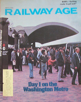
Day 1 on the Washington Metro, Railway AgeBut in 2003, in response to a regional economic downturn this proposal was junked, and was kept alive only in regional planning only within the Arlington County Master Transportation Plan, because the County understood the need for a second crossing from Virginia to DC in Rosslyn.

-- "Metro Construction Projects Creak to Halt; Economic, Political Changes Cancel Expansion Plans, Spur Job Cuts, Early Retirements," Lyndsey Layton. Washington Post, July 13, 2003. pg. C.01.

In 2006, I wrote about how DC should use Virginia's creation of the Silver Line in Fairfax and Loudoun Counties, in part to serve Dulles Airport, to bootstrap the creation of the Separated Blue Line.

-- "Blinking on urban design means you limit your chance for success"

And that without adding crossing capacity into DC, this expansion was going to create service problems within the existing system, something that Virginia elected officials finally figured out in 2014, a few months before the Silver Line opened.

-- "The Silver Line WMATA story that WJLA-TV missed"

Over the years, I kept writing about the Separated Blue Line as a concept, as something DC should do.

Although one DDOT planner made the point that without the ability to add height, and because a goodly portion of a separated line going through the core would not add development capacity, it would be difficult to justify the expense.  Hence, increase the height limit...

In 2016, I wrote about it again, in terms of improving system reliability in the face of the serious degradation that came from the addition of the Silver Line.

The thing about "interlining," when two or more lines share a section of track is that problems on one line don't stay contained on one line. Instead, they spread to the other lines like a virus. The addition of the Silver Line has stressed the equilibrium of the original system considerably.

-- "More on Redundancy, engineered resilience, and subway systems: Metrorail failures will increase without adding capacity in the core," 2016

Later that year, a comment in Greater Greater Washington made me realize that the Silver Line could be fully separated from the Orange Line with a different alignment in Arlington County.

(A couple years ago at a meeting I talked with WMATA's planning director Shyam Kannam about these issues and then he said "we have figured out the problems that derive at Rosslyn, but we still can't figure out why the problems happen coming from the east.")

In 2017, expanding on this and other concepts, Paul Meissner and I developed a "conceptual map for fixed rail expansion" and it included a Separated Silver Line fully separate from the Orange Line.
Conceptual Future integrated rail transit service network for the Washington DC National Capitol Region. Design by Paul J. Meissner.  Concept by Richard Layman and Paul Meissner.

(Although the Silver Line section hasn't been updated to reflect my more recent thinking.)

WMATA has just announced the launch of the "BOS" -- Blue, Orange, Silver -- Line Study to figure out how to fix these problems ("WMATA to study 3 rail lines to address region's future needs," Metro Magazine). From the article:
With a goal of identifying long-term options to improve reliability, meet future ridership demand, and better serve customers, the Washington Metropolitan Area Transit Authority (WMATA) launched a two-year study of its Blue, Orange, and Silver rail lines

Today, the Blue, Orange and Silver (BOS) lines all share a single set of tracks between the Rosslyn tunnel and the Anacostia River, creating a bottleneck that limits the number of trains that can cross between Virginia, Maryland, and the District of Columbia. The limited capacity means WMATA cannot easily add more trains and has limited ability to work around service disruptions. With the current configuration, a disruption on one line can have a ripple effect on all three lines.

The BOS Study will identify potential infrastructure improvements and service alternatives to resolve these issues.
… Not quite 13 years after I first suggested that these kinds of problems would occur.

While WMATA will be focused on short and intermediate term fixes, and these days given the massive fall off in ridership, I don't expect that they are thinking about expansion or separating one or more of the lines.

But separating and extending the Silver Line should be on the table, especially for DC.

If only DC officials were up to the opportunity and challenge.

Here's what I suggested in 2016, with some updates.

Concept for a fully Separated Silver Line  

Instead of what used to be called the separated Blue Line, I now term it a separated Silver Line. It could also be thought of as a "Downtown Relief Line."

1.  Instead of merging onto the Orange Line at East Falls Church Station, instead treat that station as a transfer station and continue the Silver Line south on a new alignment to Route 50/Arlington Boulevard then east to Rosslyn, crossing to Georgetown, continuing eastward to Union Station (this adds capacity to serve Amtrak's plans for expansion), and then further east to H Street NE. (The Arlington Boulevard alignment was suggested by commenter Ryan in a thread at GGW.)

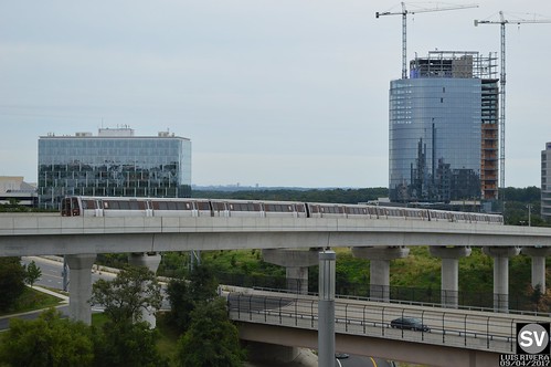
WMATA Mix Series Silver LineSilver Line in Fairfax County.

2. This would add six stations in Northern Virginia and service to a heavily used corridor.

For DC, it would add one crossing under the Potomac River, at least 9 new stations in DC, redundancy service for Downtown (and potentially 3-4 more stations if an additional Silver Line leg was constructed up Bladensburg Road).

It would serve key activity centers not currently served in Virginia (Arlington Boulevard/Seven Corners) and DC (Georgetown especially), providing additional capacity Downtown and at Union Station, which will be needed to service Amtrak expansion of Union Station.

3.  Paul indicated 8 Silver Line stations in DC.  I would say a ninth should be added at Connecticut Avenue, to connect (indirectly) to the Red Line.  I wouldn't provide a Red Line platform, because the station would be so close to both Farragut North and Dupont Circle.  Instead underground walkways could connect the Separated Silver Line to those stations.

4. In the vicinity of RFK Stadium, (and presuming the truncation of the Blue Line, see below) I would route the Separated Silver Line onto the Blue Line alignment from RFK Stadium to Largo Town Center.  That would put the new Oklahoma Avenue Station on the Silver Line.

5. At RFK, (presuming the truncation of the Blue Line) the Orange Line alignment would remain the same from Vienna to New Carrollton. But by crossing the Silver Line at this point, this would be a transfer point between the two lines, just as it is currently.

The Oklahoma Avenue station, at the western edge of the RFK site, was the only station in the original plan that ended up not being built, in face of neighborhood opposition fearing the station would be the equivalent of a "park and ride."

Rather than the aerial alignment from RFK Station to Minnesota Avenue for the Orange Line, it would be replaced by a tunnelized alignment.

The cost would be justified economically by the ability to enable superior redevelopment of the RFK Stadium site.

… speaking of lack of vision, "Mendelson aims to block DC from purchasing RFK stadium site," Washington Business Journal.  

6. Not indicated on the Meissner-Layman map, an infill Orange Line station could be built at the old Pepco generating site, providing additional service for the RFK area on the northeast.  This would be a 10th station for DC deriving from a "Separated Silver Line"."

(Controversially, because the Park Service has more golf courses than demand, the Langston Golf Course could be redeveloped.  Although the course is particularly important to local African[-American history and likely such a move would be opposed, and would also require approval of Congress and the Executive Branch, separate from the RFK situation, which is equally complicated.)

7. The proposed separate intra-city leg along Bladensburg Road from H Street to New York Avenue and Fort Lincoln could be extended further into Prince George's County if Maryland is interested.

This would provide Metrorail service to the New York Avenue corridor, if somewhat circuitous, and could also connect to a new infill New York Avenue station on the MARC passenger rail system ("One big idea: Getting MARC and Metrorail to integrate fares, stations, and marketing systems, using London Overground as an example," 2015).

DC economic development benefits.  As mentioned, the economic development benefits for DC of a Separated Silver Line would be incredible, especially if the Height Limit were tweaked.  But even if not, offhand I see incredible potential.

Central DC.  First, it would strengthen Georgetown so it can remain competitive as a regional entertainment and retail destination (starting a couple blocks up from M Street, Wisconsin Avenue's retail offer is weak)--although it would obviate the need for a gondola connection between Rosslyn station and DC.  Second, it would help Golden Triangle and Dupont Circle for both office and multiunit residential.  It would allow for intensification around Mount Vernon Triangle.  It would provide additional service to a growing Union Station.

Eastern DC.  It would add Metrorail service to the H Street corridor, one of the city's hottest entertainment districts.  It would provide the ability to do world class redevelopment of the RFK Campus, would revive and drive interest in the Minnesota Avenue-Benning Road corridor and Ward 7, and would move the redevelopment of the Pepco site forward.

Similarly, if a secondary Silver Line leg went up Bladensburg Road, the same thing, especially at the intersection of New York Avenue, which is grim now but full of potential.  It could also provide the impetus for additional development and necessary redevelopment at Fort Lincoln (although so many of the buildings are tied up as condominiums).

And if people would make the hard choice about Langston Golf Course, something no one seems to be willing to come out for ("The Langston Initiative: A New Vision for the District's Public Golf Courses," DC Federal City Council), that would be great too, although would come at the loss of some underutilized open space.

But it should be acknowledged that demand for golf courses has been dropping for some time ("Golf's challenges have country clubs in the rough. Here's how courses are fairing in the U.S.," Sports Business; "The Decline of Golf in 2018 – The Perfect Storm Continues For Most Golf Clubs," Golf Operator Magazine; "Dead Golf Courses Are the New NIMBY Battlefield," CityLab).

All told, this addition to economic capacity for the city, along with the improvement to the city's transit system and the addition of 10 new stations in DC (+ 6 in Northern Virginia) ought to make this a no brainer.

=======
Orange and Blue Line changes

The Meissner-Layman conceptual map proposes extending the Orange Line on both ends, in Virginia and Maryland.  Note that the I-66 toll concession agreement puts a time delay on possible Orange Line extensions westward.

Also, Paul and I "tussled" over ideas for the Blue Line ("Update to the Paul J. Meissner produced integrated high capacity transit map for the Washington metropolitan area," 2017).

 I wanted to end it in Rosslyn/Georgetown.  He came up with a separate Pink Line to serve the Columbia Pike corridor as well as continued it into DC and Maryland.  After he was done "designing," I realized that my truncated Blue Line could be joined with his Pink Line.

While it's true that people don't like transferring, and research finds that transfers decrease ridership, at the same time research finds that if service is frequent and transfer connections are reliable, people can deal.

Otherwise, the Blue and Orange Lines would remain interlined.

Or given the change in service on the Yellow Line, which will now go to Greenbelt all the time, again, the Blue Line could truncate and end in Rosslyn, and people could either transfer to the Orange line there for service to Northern Virginia or DC, to the Yellow Line to get into DC, or at a new Separated Silver Line to either Virginia or DC.

==========
This is also an example of what I call Transformational Projects Action Planning.

Vision plans to accomplish quantum change: Transformational Projects Action Planning.  Separately, over time, I've developed an approach to master or comprehensive planning that I now call transformational projects action planning. As part of master plans, I propose setting up a key set of big projects to focus on, projects with multiplicative and scalar benefits.
These are the most recent expressions:

-- "(Big Hairy) Projects Action Plan(s) as an element of Comprehensive/Master Plans," 2017
-- "Why can't the "Bilbao Effect" be reproduced? | Bilbao as an example of Transformational Projects Action Planning," 2017
-- "Downtown Edmonton cultural facilities development as an example of "Transformational Projects Action Planning" 2018
-- "Minneapolis Super Bowl: Urban Revitalization and Transformational Projects Action Planning," 2018

The basic idea is that a master plan should include a set of big, hairy audacious projects (like "big hairy audacious goals") to spur revitalization and community improvement in a substantive way.
TPAPs should be implemented at multiple scales:

(1) city/county wide as part of a master plan;

(2) within functional elements of a master plan such as transportation, housing, or economic development; and

(3) within a specific project (e.g., how do we make this particular library or transit station or park or neighborhood "great"?).

Labels: , , , , ,