Rebuilding Place in the Urban Space

"A community’s physical form, rather than its land uses, is its most intrinsic and enduring characteristic." [Katz, EPA] This blog focuses on place and placemaking and all that makes it work--historic preservation, urban design, transportation, asset-based community development, arts & cultural development, commercial district revitalization, tourism & destination development, and quality of life advocacy--along with doses of civic engagement and good governance watchdogging.

Tuesday, November 04, 2025

Better late than never? DC Metrorail Blue Line Corridor Coalition advocates for TOD, 45 years after line opens

TOD = transit oriented development--office buildings, residential buildings, retail, mixed use buildings containing portions of the other three.

The Blue Line is one of six DC Metrorail heavy rail lines.  The bulk of the line opened in 1977, at that time ending on the east at Stadium-Armory in DC.  Two stations in Prince George's County opened in 1980, Capitol Heights and Addison Road, along with Benning Road in DC ("Signs of Change, Missing on Metro," Washington Post).  

Largo station was renamed Downtown Largo aspirationally, as a new medical center was built there and with hope renewed for revitalization.

Later Maryland paid to extend the line two stops east, to provide service to professional football's FedEx Stadium.  Service to Morgan Boulevard and Largo Town Center commenced in 2004 ("Three New Metro Stations To Open Before Year's End," Washington Post).

The area served by the Blue Line in Prince George's County has languished for decades ("The Commanders may relocate. Neighbors say good riddance," Washington Post).  At one point, the area's professional basketball and hockey teams played at Cap Centre, along the corridor.  When the teams moved back to DC, a shopping center was built in its place, and didn't do well.

Once the Washington Commanders football team indicated it would abandon its stadium in Largo, the county has realized it needs to pay attention and put resources into improvement ("Maryland pitched expansive development to keep Commanders — and stave off economic devastation if they leave," Washington Post).  This year the team signed an agreement to move to DC.

Why they didn't do it before, especially because sports teams are lauded as great platforms for ancillary development ("You get what you plan for: the multi-use Miami Hard Rock Stadium versus typical football stadiums | Washington Commanders" and "Sports facilities and the reproduction of retail space often doesn't work for the locals") is beyond me.

Vision for a new Downtown Largo, with the football stadium in the upper left of the rendering.

Out of the failed effort to keep the football stadium, the Blue Line Corridor Coalition was formed.

--"Prince George's County's newly announced transit oriented development program for the Blue Line," 2022
-- "Backwardness of transportation and land use planning: National Harbor, Prince George's County, Maryland | Why isn't high capacity transit access required from the outset?," 2022
-- Branding for Downtown Largo, Maryland National Park and Planning Commission
-- "Major Blue Line projects aim to transform Prince George’s County. Residents hope it’s for the better," WAMU/NPR
-- Ten Principles for Developing Successful Town Centers, Urban Land Institute, 2007

According to the WTOP article from a few days ago, "Blue Line Corridor Coalition aims to keep revitalization alive in this part of Md.," the initiative is revving up.

The “Blue Line Corridor” is Prince George’s County’s main economic redevelopment and revitalization project, and the wheels were put into motion before the federal upheaval started impacting the region. Those involved say that upheaval has made the job harder, but it isn’t putting a stop to the project.

A group of developers, elected leaders, business owners and residents came together Wednesday to celebrate the creation of the Blue Line Corridor Coalition. It’s a group that aims to bring together all the stakeholders focused on revitalizing the area closest to the D.C. line and make sure everyone is pulling in the same direction.

“It’s to coordinate our efforts so that we’re moving more strategically, we don’t waste resources, but we also make sure that everyone’s bought in to what eventually happens,” state Del. Jazz Lewis said.

....“We have four metro stops, and 15% of the land around those metro stops is vacant lands,” he said. “Where in other parts of our region can you see vacant land, near Metro? So as the gateway to D.C., with connections to Amazon headquarters, with connections to Dulles and to DCA, not to mention the Capitol, this central part of the county, the Blue Line corridor, is primed for revitalization. We want to make sure that revitalization is community driven.”

But why should it have taken so long to leverage the development opportunity from transit?  The Blue Line stations in Prince George's fist opened in 1980.

From the Washington Informer article, "Central Prince Georgians Launch Blue Line Corridor Coalition:"

“We are here to rehearse the future,” said Bryan Franklin, the deputy director of Local Initiatives Support Corporation (LISC), to the gathering of 30 people at Mini Plaza shopping center in Seat Pleasant. “At the core of the coalition is the vision to create a thriving Blue Line Corridor where history and culture fuels progress, and those who call these neighborhoods home share in its growth. We’re collectively rehearsing a future where vacant lots turn into new homes, a six-lane highway turns into a walkable boulevard and where empty storefronts transform into places where memories are made. The BLCC is built on five years of community engagement, over $6 billion of investments, and a LISC model to generate a 4:1 return on investment.” 

 (FWIW, DC LISC has never impressed me.  LISC groups in other cities are better.

Past writings:

-- "The future of mixed use development/urbanization: Part 3, Prince George's County, where's the there?," 2011
-- "A recommended new planning direction for Prince George's County," 2011
-- "Another lesson that Prince George's County has a three to five year window to reposition based on visionary transportation planning," 2011
-- "Frustration #3: the talk about transit oriented development and Prince George's County," 2013
-- "Prince George's County still doesn't get "transit oriented development" and walkable communities: Greenbelt edition," 2012

Why did it take so long for them to get purposive? | What to do?

1.  No vision.  Build it and they will come was the paradigm.  Trickle down development takes decades.

 Even though it has a total of 14 Metrorail stations on four different lines, Prince George's County didn't think it needed to change in the face of Metrorail.  Didn't think of Metrorail as an opportunity, a way to leverage and reposition the county's development vision towards transit and away from automobile dependence.

By contrast, Montgomery County has significantly leveraged the Red Line, which often serves what had been preexisting centers and built upon them.  Arlington County shifted to an in-county for the Orange Line from an in-freeway routing, spurring billions of dollars of revitalization ("The Effect of Transit-Oriented Development in Arlington, Virginia on Transportation Choices").

The county has had a few transit focused revitalization initiatives but they were under resourced and support was intermittent.  

2.  That's why you need a related "Transformational Projects Action Planning" ("Updating the best practice elements of revitalization to include elements 7 and 8 | Transformational Projects Action Planning at a large scale") process for transit lines and transit stations, to best leverage the return on investment from transit infrastructure.

3. Relatedly but subtly different is what I call a plan to leverage new transit infrastructure to drive complementary improvements across the transit network, to further improve ridership and the likelihood of success.  I've written a few such conceptual pieces, the most realized is for the Purple Line light rail in Montgomery and Prince George's County.

-- "Codifying the complementary transit network improvements and planning initiatives recommended in the Purple Line writings," (2022)

-- Setting the stage for the Purple Line light rail line to be an overwhelming success: Part 1 | simultaneously introduce improvements to other elements of the transit network (2017)
-- Part 2 |   the program (macro changes) (2017)
-- Part 3 |   influences (2017)
-- Part 4 |   Making over New Carrollton as a transit-centric urban center and Prince George's County's "New Downtown" (2017, originally 2014)
 -- Part 6 |  Creating a transportation development authority in Montgomery and Prince George's County to effectuate placemaking, retail development, and housing programs in association with the Purple Line (2017)
-- Part 7 | Using the Purple Line to rebrand Montgomery and Prince George's Counties as Design Forward (2017)
-- Revisiting the Purple Line article series after one year: Part 1 | a couple of baby steps (2018)
-- Revisiting the Purple Line (series) and a more complete program of complementary improvements to the transit network (2019)

4.  PG County was given a second chance with the Purple Line light rail line but still hasn't fully jumped on the opportunity.

One thing I'd add to their agenda is extending the Purple Line west towards Virginia to connect to the Blue and Green Lines.  

There is zero expansion planning of the Purple Line currently--the line (from Bethesda to New Carrollton on this map, with 20 stations) is now going to open in January 2028.

It would definitely add connectivity value to the Blue Line corridor.

5.  Fortunately the Blue Line Corridor Coalition appears that they are ready wants to do large scale revitalization planning for the football stadium site,  And the County is already committed to repattern the urban form of Largo ("Downtown is not a word without meaning: renaming the Largo Town Center to Downtown Largo is without meaning," 2021).  It's going to be a couple decade process, especially with the decreased demand for commercial space.

6.  For years, I've suggested PG County move its county center to a metro station catchment area.  They did move a bunch of agencies to Largo, but they are mostly disconnected.  Such a move, while expensive could be transformational.

Racism and Equity

It could be argued that as the metropolitan area's only majority black county that there has been deliberate disinvestment.  I won't argue the point.  But like most regions, the metropolitan area is not unique in shifting west over the decades.

That being said, for decades PG County has been recognized as a relatively high income majority black county.

There is probably less real estate development vis a vis the demographics and because there are better returns elsewhere.  

Some developers say that PG County Schools lag significantly compared to other jurisdictions so they are reticent to build housing for fear it won't sell (or at least not for what they can get in better locations).

There have been attempts to attract government agencies to Metrorail stations.  Some have located at New Carrollton.  Others are in the vicinity of College Park Station.  The County has been unsuccessful in landing the FBI at Greenbelt.  

Like I've argued for DC's East of the River, St. Louis, Pontiac, Michigan, and the East side of Montgomery County, this section of PG County needs a focused revitalization plan.

-- "I wonder if Mayor Fenty hadn't dissolved the Anacostia Waterfront Initiative in 2007, merging it into another city agency, if development would have happened faster?," 2024
-- "Revisiting the 11th Street Bridge Park project as an opportunity rather than a folly: a new revitalization agenda for East of the River, DC," (2024)
-- St. Louis: what would I recommend for a comprehensive revitalization program? | Part 1: Overview and Theoretical Foundations," (2021)
-- "St. Louis: what would I recommend for a comprehensive revitalization program? | Part 2: Implementation Approach and Levers," (2021)
-- "Revisiting St. Louis revitalization planning in the face of population shrinkage," (2023)
-- "Pontiac Michigan: a lagging African American city in one of the nation's wealthiest counties," (2022)
-- "East County, Montgomery County, Maryland: Council redistricting spurs ideas for revitalization | Part 1 -- Overview," (2021)

Labels: , , , ,

Thursday, December 29, 2022

More remonstration about the molasses of change: Transit planning, Baltimore County, Maryland and Towson

In the 1960s and early 1970s, the Urban Mass Transit Administration was funding "next generation subway" systems in the San Francisco Bay (BART), Atlanta (MARTA), Miami (Metrorail), Washington (WMATA), and Baltimore (Metro).

But Baltimore was late to the party, and instead of getting funding for all six of its planned lines, it got funding for one.  Note that Atlanta, BART, and Miami had problems of their own--certain suburban counties refused to participate for both Atlanta and BART, and Miami's route planners designed the system to serve areas they wanted to develop, rather than to ensure that service was also provided to key activity centers.

Comparing DC to Baltimore and the impact of transit made me realize how important to revitalization is a network of multiple lines serving residential and office districts and other activity centers, like airports, versus a single line.

For example at DC's core of 31 Metrorail stations, every one of those neighborhoods have improved reversing decades of decline.  Granted it took as much as 40-45 years to accomplish this.

Baltimore light rail in Downtown.  It's not sleek but has a kind of charm.  In my Purple Line writings, I've suggested as part of the contract, Maryland could upgrade to new cars on the Baltimore light rail.

Flickr photo by SoCal Metro.

Later, Maryland Governor Schaefer created a complementary light rail line, from a small industrial railroad that went bankrupt.  While serving Downtown Baltimore, the line wasn't that great from a transit network perspective, because it was built on a route that served industrial sites, not residential and commercial areas.  

In particular, it bypassed Towson, the county seat and the county's primary business district (unfortunately, the single subway line didn't go far enough east to serve the county's other primary business district, White Marsh).

In the interim the metropolitan planning organization proposed a secondary light rail line that would provide service directly to Towson, as well as to Columbia, Maryland, a primary activity center in Howard County.

Baltimore Regional Transit Expansion Map, 2002.

When I worked for Baltimore County in FY2010, as a bicycle and pedestrian planner, simultaneously the master plan update was going on, and I was asked to submit a briefing paper on transit and sustainable mobility.

The major point I made was that the transit lines needed to be knitted into a network and that the light rail needed to be rerouted to serve Towson directly and that the subway line needed to be extended to White Marsh.  

-- "From the files: transit planning in Baltimore," 2012, written originally in 2010

A secondary point was that the subway and light rail could be connected more directly in Baltimore City.  I didn't mention a southern extension to Columbia, because the memo was about Baltimore County, but that was implied.  

A few years later, a planner for MDOT made the point that the light rail should also be extended just one half mile to one mile north, to better serve the business district in Cockeysville where McCormick Spice is based.  Had I known that at the time, I would have suggested that too.

Now everything I wrote was rejected because it was at the peak of the post-2008 recession, and the planners were ordered to omit "any recommendations that cost money."

For what it's worth, over the past ten years, the regional recommendations for transit were incredibly paltry and stunted, in part because the Republican Governor, Larry Hogan, had negative interest in transit, except for maglev.

-- "Small update: Transit agenda for Greater Baltimore," 2021-

It appears that's changing.

Caption: see below 

There is an article a few months ago in the Baltimore Sun, "Maryland transportation officials ask for public comment on potential transit routes from Towson to Baltimore," that planners are suggesting that Towson be served directly by light rail.  From the article:

State transportation officials are asking for public input on seven proposed transit routes that would connect Towson to downtown Baltimore.

The Maryland Department of Transportation Maryland Transit Administration unveiled seven options for a new north-to-south transit line connecting Baltimore County to Baltimore City by light rail, bus or subway. The seven proposed “alternatives” were identified in a feasibility study completed in 2021. The assessment is one of the first out of 30 transit corridors the agency will study as part of its 25-year Regional Transit Plan aimed at improving public transportation in Central Maryland.

That could have been accomplished already. 

Especially if it had been prioritized in the 2010 Baltimore County Master Plan.

Building new infrastructure is hard enough, without politics and opposition interfering.

The Baltimore, Atlanta, Miami, and San Francisco examples have made me realize that it's almost impossible to do these projects "right" when major activity centers aren't included as part of the basic service program.

Caption from the Baltimore Sun.  Maryland Department of Transportation Maryland Transit Administration unveiled seven proposed transit lines from Towson to Baltimore in its “North-South Corridor Study,” an assessment completed in 2021 that’s one of the first of 30 corridor studies aimed at making public transportation more efficient in central Maryland. 

Alternative 1 (pink) Light Rail Transit from Lutherville to University of Maryland Medical Center (UMMC) via York Road/Greenmount Avenue. 

Alternative 2 (dark red) Bus Rapid Transit from Lutherville to University of Maryland Medical Center (UMMC) via York Road/Greenmount Avenue. 

Alternative 3 (purple) Bus Rapid Transit from Towson to Harbor East, via York Road/Greenmount Avenue. 

Alternative 4 (light green) Heavy Rail Transit (Subway) from Towson to Port Covington, via York Road/Greenmount Avenue. 

Alternative 5 (dark green) Bus Rapid Transit from Towson to Port Covington, via York Road/Greenmount Avenue. 

Alternative 6 (blue) Light Rail Transit from Lutherville to Otterbein, via Goucher Boulevard, Loch Raven Boulevard. 

Alternative 7 (oramge) Bus Rapid Transit from Towson to Harbor East, via Joppa Road, Loch Raven Boulevard.

Labels: , , , ,

Monday, February 28, 2022

Backwardness of transportation and land use planning: National Harbor, Prince George's County, Maryland | Why isn't high capacity transit access required from the outset?

In 2007, I took a class on transportation and land use planning, and my term paper laid out an agenda for linking transportation and land use planning within DC proper, although the concepts were extendable to the metropolitan area.

Some blog entries reflect the various conclusions in the paper, including whether or not DC should move to "free transit," which is relevant again as DC Council is proposing $100/month in free transit benefits to all residents ("D.C. Council Ponders Bill to Give Residents $100 Monthly to Ride Metro," Washington Informer).

-- "Comments on Proposed EYA Development at Takoma Metro Station," 2006
-- "Not being able to build your way out of congestion," 2007
-- "A 2008 Transit/Transportation Planning Wish List for DC," 2008 (updated 2015, part 1, part 2)
-- "Is making surface transit free the best transit investment DC can make?," 2016

Predating the paper, the 2006 entry discusses the "Transit First" agenda laid out in the San Francisco City Charter, which prioritizes sustainable mobility, while the 2007 entry discusses "Transit First" as well as how Utrecht, The Netherlands links land use approvals to the capacity of the transportation system to accommodate the number of trips generated ("Utrecht: 'ABC' Planning as a planning instrument in urban transport policy"). These provide the foundation for the paper's argument.

PG: no substantive link between transportation and land use planning, especially for big projects.  Unlike what they do in Utrecht, it is amazing how in Prince George's County in particular, they approve large scale developments -- FedEx Stadium, Konterra, and the National Harbor development on the Potomac River alongside an outlet shopping center and the MGM Grand Casino -- WITHOUT ANY REQUIREMENTS FOR HIGH CAPACITY TRANSIT SERVICE.  Even though they claim to be proponents of what is called "transit oriented development."

Konterra is still a long way from substantive development, but it's completely car dependent.  

FedEx Stadium is about 1.5 miles from the Largo Town Center Metrorail Station, and National Harbor has zero substantive transit connections--it was hard to even get bus transit.

It's why I argue that Prince George's County planners don't really understand what transit oriented development and transit centricity even mean:

-- "The future of mixed use development/urbanization: Part 3, Prince George's County, where's the there?," 2011
-- "A recommended new planning direction for Prince George's County," 2011
-- "Another lesson that Prince George's County has a three to five year window to reposition based on visionary transportation planning," 2011
-- "Frustration #3: the talk about transit oriented development and Prince George's County," 2013
-- "Prince George's County still doesn't get "transit oriented development" and walkable communities: Greenbelt edition," 2012

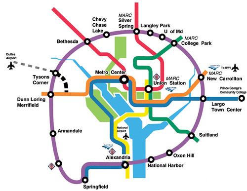
National Harbor.  And wrt National Harbor specifically, there are limited bus connections only, which came with a struggle ("Eight years and one casino later, a bus line from Alexandria to National Harbor," Post, 2016), even though the Sierra Club Metro DC Chapter advocated for a circumferential transit line connecting all the legs of the Metrorail system c. 2000.  This proposal included a station at National Harbor.

This comes up because the Washington Post has an article, "In growing National Harbor, eyes are once again set on a future Metro station," about the possibility of Metrorail expansion, the long discussed separated blue line, that would provide service both to Georgetown and National Harbor as a kind of inner circumferential line for the subway system. 


WMATA's proposed separated blue line makes it sort of circular.

Purple Line.  FWIW, the first time I ever heard of the Purple Line was in a cover story in the Washington City Paper in December 1987.  And now, "only" 39 years later, the first leg will be operational ("Maryland approves revised contracts for Purple Line, now set to open in 2026," NPR).

Ironically, when the first column for what became the Dr. Gridlock feature in the Washington Post was written in 1989 or 1990, I sent a long letter to the writer about how he was advocating for car commuters, not for transportation, and that by not advocating for transit expansion then, it would take decades to happen.  

This Purple Line was originally conceptualized as heavy rail but is now being constructed--a portion anyway--as light rail.

Separated Blue line/Separated Silver Line.  The separated blue line was a WMATA concept from 2001, but after a recession around 2003, Metrorail junked expansion planning entirely, devolving authority for expansion to the separate jurisdictions, and it fired most of its long range engineering and construction staff.  The original blue line proposal called for service to Georgetown, Union Station and H Street NE.  

But the key element was the additional platforms at Rosslyn Station, as the present setup is a key chokepoint in the system, made only worse by the addition of the Silver Line.

The only expansion plan underway at the time that continued was the Silver Line, by the State of Virginia.  The second phase will open this year -- 20+ years later ("Silver Line opening pushed back again, MWAA says, as new issue arises. But hiring is underway," Washington Business Journal).

Graphic: Washington Post, 2001
(The online article never included the graphic.)

The separated blue line concept died for the most part, except as mentioned in the Arlington County Master Transportation Plan.  Instead of advocating for it, DC shifted into streetcar planning, which since the original process, has been pretty much abandoned to one line on H Street NE, ending at Union Station.

A proposed streetcar network for DC.

Starting in 2006, I wrote tons about the concept of a separated blue line, including the missed opportunity by DC to use the creation of the Silver Line as a way to create that line.

-- "The "Downtown" Circulator and Rosslyn, Virginia," 2006
-- "Blinking on urban design means you limit your chance for success," 2006
-- "Winners and losers with the Dulles subway project," 2007
-- "Silver Line Metro expansion a classic example of the need to have true regional transportation planning," 2011
-- "Ultimately, WMATA blue line riders have been dissed by the State of Virginia, not WMATA," 2013
-- "The Silver Line WMATA story that WJLA-TV missed," 2014
-- "If DC had visionary elected officials and planners it could use the new WMATA "BOS" study to push through the development of a separated Silver Line in DC (and Northern Virginia)," 2019 recap

Although now I think it could be a separated Silver Line and the Blue Line, in Virginia could have its own expansion plan.

-- "A "Transformational Projects Action Plan" for the Metrorail Blue Line," 2020

Separately Paul Meissner and I created a "fantasy map" for Metrorail expansion, which did include Metrorail service to National Harbor, but should have included other suggestions for Blue Line extension in Virginia.

Design by Paul Meissner
Concept by Paul Meissner and Richard Layman

Note that this map has a southwestern leg of the Green Line from Suitland, serving National Harbor as the terminus.  This map didn't call for a completion of the Purple Line circumferential line.  

Now, I'd probably drop the southwestern Green Line leg in favor of an extension of the Purple Line from New Carrollton to Alexandria, with service to National Harbor, albeit at a distance of 7 miles from the Suitland Metrorail station.

The new separated blue line proposal.  So far, I am not enamored with the Metrorail blue line proposal, although it does provide:

I'd rather see the Separated Silver Line, and extension of service east of Union Station rather than southward from Union Station to National Harbor, although the issue of enhanced special event coverage to Nationals Stadium and Audi Field is a plus.

To me, planning an extension of the Purple Line from New Carrollton to Alexandria makes more sense, based on the likelihood of ridership demand to National Harbor, which can't be particularly high.

According to the Post article:
The route would add 180,000 new weekday trips, according to pre-pandemic Metro estimates made when the existing rail system was serving four times the passengers it does now. The route would bring rail service to lower-income communities in the District and Prince George’s, as well as to areas where development is booming, such as Buzzard Point and National Harbor. ...

Proponents of the proposed National Harbor line take a much longer-term view. It’s the preferred of six options the Metro board is considering to deal with crowded stations on the Blue, Orange and Silver lines. Trains and stations on the three lines, which share one set of tracks through much of the District, frequently exceeded capacity before the pandemic during peak hours, according to Metro. 

The Blue Line route would connect an area of Prince George’s with few transit options — limited to a handful of bus routes — to the greater Washington area. It also would create an alternative to car travel in an area that suffers from frequent traffic congestion. 

“It would be a tremendous amount of relief if folks were able to depend on mass transit,” said Malcolm Augustine, a former member of Metro’s board who represented Prince George’s and is now a state senator. 

The down side? It would come with a hefty price tag, costing between $20 billion and $25 billion to build and between $175 million and $200 million annually to operate, according to a Metro report last fall. It’s not clear how the extension would be funded.
Bang for the buck.  The thing is that extending the Blue or Silver Line eastward into DC and even Prince George's County would serve areas that are more intensely developed or could be, thereby generating more ridership and greater likelihood of transit oriented development.  Metrorail service on H Street and potentially up Bladensburg Road would have huge impacts, greater than what is likely south of Buzzard Point (Audi Field).

Transit planning and transit operations need to be separated.  It's also an illustration of the failure to not have integrated transportation and land use planning in the Washington Metropolitan Area.  I argue for the creation of a German style transport association, which integrates transit planning and operations regardless of mode.


WMATA is the heavy rail (and regional bus) operator and by default it is the lead transit planner, even though it has to make recommendations designed to assuage all three jurisdictions rather than optimality, and often makes decisions that are budget constrained.  

WMATA is also biased.  It doesn't see itself as a "transit operator" but as the Metrorail operator.  It wasn't interested in taking on light rail, which is why the Purple Line is being developed under the authority of the Maryland Mass Transit Administration.  It doesn't care about railroad passenger service, which is why 

Instead, there should be a regional transportation association, planning should be separated from operations, and decisions should be made in terms of the best mode, regardeless of who operates it.

What should happen.

1.  WMATA should study a separated blue line and a separated silver line, with broader cost-benefit calculations including land use intensification.  Obviously new platforms at Rosslyn are a top priority.

So is connection to Georgetown, redundancy in the center city, and an additional connection to Union Station, to support growth plans for the station.


At the same time, DC needs to consider the height limit restrictions (2010 blog entry, "More discussion of the height limit #2: Without adding high capacity transit service, there should be no increase in allowable heights," 2012) because taller development would help pay for the cost of the subway extension.

And DC needs to decide if it prefers eastward expansion of the Silver/Blue Lines, or better connections to Nationals Stadium and Audi Field, which then means extension southward into Prince George's County and to National Harbor.

2.  Immediately, the metropolitan area and Maryland MTA should begin studying the extension of the Purple Line from New Carrollton to Alexandria, with the aim of implementing it so much faster than the current process.

A caveat concerning the pandemic's effect on transit ("After Massive Transit Losses during the Pandemic, Agencies Are Planning a Comeback," Urban Institute, "Steep ridership losses will force changes to Metro service after pandemic, transit leaders say," Washington Post).  We don't know if Downtown DC (and Downtowns elsewhere) is dead forever, that the pandemic ushers in a world where people no longer go work in offices and clusters.  

I don't think that's the case, but I can't be absolutely sure.  If that's the case, high capacity transit is no longer necessary, at least from the suburban to city standpoint.

Then it becomes more of a place enhancement and intensifier, and still makes sense, but even then only if people are still working "downtown."

Labels: , , , , , ,

Monday, May 04, 2020

Just a reminder that what are called "public private partnerships" are contracts, not partnerships

-- "Design-Build Team Makes Decision to Leave Maryland Purple Line Rail Project," Engineering News-Record

The State of Maryland signed a contract with a group of various firms to design, build, operate,  maintain and partly finance the forthcoming Purple Line light rail line in Suburban Maryland.  In turn, the group created a separate subsidiary to construct the line.

Washington Post graphic showing the route of the line.

There are various disputes between the State and the consortium over delays and changes that result in greater costs and who is responsible for paying.

Because negotiations up to now haven't resulted in resolution, the construction firm has given notice per the contract to walk away.

Um, despite all the happy talk about "public private partnerships," in normal circumstances, that's not how "partnerships" are supposed to work.

Although this is not new.  The reality is that these are contractual agreements, and very hard to change once underway.  And as contracts, there is little interest in flexibility and changes and improvements once the construction is underway.

From "The Theory and Practice of Infrastructure Public-Private Partnerships Revisited: The Case of the Transportation Sector":

PPPs are widely promoted based on a narrative of improved collaboration between different stakeholders. By aligning the interests of the multiple parties to encourage closer and more productive working relationships, it is argued that public-private partnerships support innovative project designs and deliver value for money by better controlling project risks. Despite the promises, however, relationships between the various partners in PPPs have often turned from collaborative to confrontational, threatening the success of the project.

This is reality. And as a result, I think it's better to call these kinds of arrangements contracts, not partnerships.


I was trying to hook up with one of the teams that bid on this project. They didn't win. And the experience led them to abandon future efforts on such large scale projects (although the firm remains one of the nation's largest construction firms).

One of the problems with projects like this is that they are so few and far between (the same goes with manufacturing passenger transit vehicles of all types) that it's hard to build economies of scale.)

And early on in the post-bid acceptance process, I learned there was no room for innovative station area planning and development, etc., because "it's not in the contract."

-- "A Purple Line update: the downside of Public Private Partnerships" -- they are contracts, not partnerships," 2017
-- "It's not like transit "outsourcing" I mean "public-private partnerships" are necessarily smooth sailing," 2018

Which is one of the reasons why my brilliant writings around the Purple Line will have no effect.

-- "Revisiting the Purple Line (series) and a more complete program of complementary improvements to the transit network," 2019

-- Setting the stage for the Purple Line light rail line to be an overwhelming success: Part 1 | simultaneously introduce improvements to other elements of the transit network
-- Part 2 |   the program (macro changes)
-- Part 3 |   influences
-- Part 4 |   Making over New Carrollton as a transit-centric urban center and Prince George's County's "New Downtown"
-- PL #5: Creating a Silver Spring "Sustainable Mobility District"
-- Part 6 |  Creating a transportation development authority in Montgomery and Prince George's County to effectuate placemaking, retail development, and housing programs in association with the Purple Line
-- Part 7 | Using the Purple Line to rebrand Montgomery and Prince George's Counties as Design Forward

-- PL #5: Creating a Silver Spring "Sustainable Mobility District"
Part 1: Setting the stage
Part 2: Program items 1- 9
Part 3: Program items 10-18
Part 4: Conclusion
Map for the Silver Spring Sustainable Mobility District
(Big Hairy) Projects Action Plan(s) as an element of Comprehensive/Master Plans
Creating the Silver Spring/Montgomery County Arena and Recreation Center

Labels: , , , , ,

Tuesday, February 25, 2020

Detailed service improvement plan for SEPTA Market-Frankford Line is a model for other transit systems

In writing ("Train service in Greater Manchester needs to be reorganized?") about service failures of the railroad commuter service program south of London, I referenced a report-analysis commissioned from experienced railroader Chris Gibb.  It made very detailed and incisive recommendations about the problems and potential solutions.

(Separately, I remember reading detailed improvement recommendations by the labor union working on NYC Subway and by contrast, politically oriented but content-less recommendations by the union working on the WMATA Metrorail system.)

Granted busline improvement programs in places like Seattle ("How Seattle Got More People to Ride the Bus," City Lab) and Salt Lake City ("New and Improved: Expanded Service Hits Salt Lake City ," press release), mostly focused on upping frequency, have had positive results seen in significant ridership increases, even as transit ridership tends to be dropping somewhat on a national basis ().  In both cities, improvements have been funded by city-specific funding initiatives separate from the multi-jurisdictional serving agencies ("UTA unveils improved bus shelters and signs funded by Salt," Salt Lake Tribune).

The PATH system too, has a substantive system improvement program underway that is quite quantifiable ("Port Authority announces plan to increase PATH capacity," ABC7 NYC).

The Philadelphia Inquirer has a story, "The Market-Frankford Line is SEPTA's workhorse. A 'dramatic change' to service starts soon," on SEPTA's various measures for the Market-Frankfort elevated line, which is the system's busiest single line, with over 180,000 daily riders.

Given the rise in new residential development in the area immediately served by the line, ridership has significantly increased, and the agency has had to respond to deal with crowding and other problems.

In terms of baseline service, the line operates with peak frequencies of four minutes across the peak travel periods, from 7 a.m. to 9 a.m. and 4 p.m. to 6 p.m, and less frequent service outside of those periods.

Service improvements include:

  • Elimination of skip/stop service, where during peak service, A trains skipped certain stations and B trains skipped other stations; leading to long waits on the part of some riders. The elimination of skip-stops will improve service from a train every eight minutes to a train every four minutes during peak hours.
  • From 6 p.m. to 7 p.m., frequencies will improve from a train every 10 minutes to a train every six minutes.
  • From 7 p.m. to 8 p.m., frequencies will improve from a train every 10 minutes to a train every eight minutes.
According to the PI:
The skip-stop service’s end impacts eight stations, mostly concentrated on the east end of the line, at the Berks, York-Dauphin, Huntingdon, Somerset, Tioga, and Church stations, as well as Millbourne and 63rd Street on the west end.
They are also reconfiguring train seating to add more space for standing--they are 20% of the way through, and hope to install real-time information on train arrivals, but no money has been allocated for such an improvement.

(I know one of my complaints with DC's Metrorail is the surcharge for rush hour during the periods when service is much less frequent.)

That being said, SEPTA has other issues, including problems with structural integrity of the train cars which has created service problems and some advocates argue that the system needs to be "more transparent and open" about what's going on ("Market-Frankford Line issues underscore need for more transparency from SEPTA," PI).

Labels: , , , , , ,

Thursday, June 20, 2019

If DC had visionary elected officials and planners it could use the new WMATA "BOS" study to push through the development of a separated Silver Line in DC (and Northern Virginia)

Charlie comments on an earlier blog entry, writing:

As I keep harping on, DC could have built a separated blue line for what it wasted on various projects over the past 10 years. But that is politics, and other things come first.
===========

Pre-2003, WMATA did its own expansion planning, and proposed the creation of what was then called the "Separated Blue Line."

Proposed changes for the WMATA system, 2001 (separated blue line)
Proposed changes for the WMATA system, 2001 (separated blue line), Washington Post graphic. (This graphic was never put online, but when I was a source for a couple stories by Post reporter Lyndsay Layton she tracked it down for me.)

This was when it was expected ridership would grow, reaching 1 million daily riders in the early 2020s.  Instead, these days, ridership has dropped by about 1/6 to about 500,000.

-- "Coming to a Curve: Region's Subway System Begins to Show Its Age, Limits" By Lyndsey Layton, Washington Post, March 25, 2001; Page A01
-- "Crowds Could Derail Decades of Progress," By Lyndsey Layton, Washington Post, March 26, 2001; Page A01.

This was back when the H Street revitalization effort ("360 Apartment building + Giant Supermarket vs. a BP gas station, which would you choose?," 2013) was just starting and we advocates found tantalizing the vision of a separated Blue Line with two stations on H Street NE--I still remember reading the article and seeing the graphic!

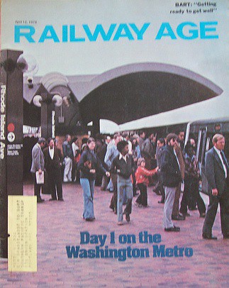
Day 1 on the Washington Metro, Railway AgeBut in 2003, in response to a regional economic downturn this proposal was junked, and was kept alive only in regional planning only within the Arlington County Master Transportation Plan, because the County understood the need for a second crossing from Virginia to DC in Rosslyn.

-- "Metro Construction Projects Creak to Halt; Economic, Political Changes Cancel Expansion Plans, Spur Job Cuts, Early Retirements," Lyndsey Layton. Washington Post, July 13, 2003. pg. C.01.

In 2006, I wrote about how DC should use Virginia's creation of the Silver Line in Fairfax and Loudoun Counties, in part to serve Dulles Airport, to bootstrap the creation of the Separated Blue Line.

-- "Blinking on urban design means you limit your chance for success"

And that without adding crossing capacity into DC, this expansion was going to create service problems within the existing system, something that Virginia elected officials finally figured out in 2014, a few months before the Silver Line opened.

-- "The Silver Line WMATA story that WJLA-TV missed"

Over the years, I kept writing about the Separated Blue Line as a concept, as something DC should do.

Although one DDOT planner made the point that without the ability to add height, and because a goodly portion of a separated line going through the core would not add development capacity, it would be difficult to justify the expense.  Hence, increase the height limit...

In 2016, I wrote about it again, in terms of improving system reliability in the face of the serious degradation that came from the addition of the Silver Line.

The thing about "interlining," when two or more lines share a section of track is that problems on one line don't stay contained on one line. Instead, they spread to the other lines like a virus. The addition of the Silver Line has stressed the equilibrium of the original system considerably.

-- "More on Redundancy, engineered resilience, and subway systems: Metrorail failures will increase without adding capacity in the core," 2016

Later that year, a comment in Greater Greater Washington made me realize that the Silver Line could be fully separated from the Orange Line with a different alignment in Arlington County.

(A couple years ago at a meeting I talked with WMATA's planning director Shyam Kannam about these issues and then he said "we have figured out the problems that derive at Rosslyn, but we still can't figure out why the problems happen coming from the east.")

In 2017, expanding on this and other concepts, Paul Meissner and I developed a "conceptual map for fixed rail expansion" and it included a Separated Silver Line fully separate from the Orange Line.
Conceptual Future integrated rail transit service network for the Washington DC National Capitol Region. Design by Paul J. Meissner.  Concept by Richard Layman and Paul Meissner.

(Although the Silver Line section hasn't been updated to reflect my more recent thinking.)

WMATA has just announced the launch of the "BOS" -- Blue, Orange, Silver -- Line Study to figure out how to fix these problems ("WMATA to study 3 rail lines to address region's future needs," Metro Magazine). From the article:
With a goal of identifying long-term options to improve reliability, meet future ridership demand, and better serve customers, the Washington Metropolitan Area Transit Authority (WMATA) launched a two-year study of its Blue, Orange, and Silver rail lines

Today, the Blue, Orange and Silver (BOS) lines all share a single set of tracks between the Rosslyn tunnel and the Anacostia River, creating a bottleneck that limits the number of trains that can cross between Virginia, Maryland, and the District of Columbia. The limited capacity means WMATA cannot easily add more trains and has limited ability to work around service disruptions. With the current configuration, a disruption on one line can have a ripple effect on all three lines.

The BOS Study will identify potential infrastructure improvements and service alternatives to resolve these issues.
… Not quite 13 years after I first suggested that these kinds of problems would occur.

While WMATA will be focused on short and intermediate term fixes, and these days given the massive fall off in ridership, I don't expect that they are thinking about expansion or separating one or more of the lines.

But separating and extending the Silver Line should be on the table, especially for DC.

If only DC officials were up to the opportunity and challenge.

Here's what I suggested in 2016, with some updates.

Concept for a fully Separated Silver Line  

Instead of what used to be called the separated Blue Line, I now term it a separated Silver Line. It could also be thought of as a "Downtown Relief Line."

1.  Instead of merging onto the Orange Line at East Falls Church Station, instead treat that station as a transfer station and continue the Silver Line south on a new alignment to Route 50/Arlington Boulevard then east to Rosslyn, crossing to Georgetown, continuing eastward to Union Station (this adds capacity to serve Amtrak's plans for expansion), and then further east to H Street NE. (The Arlington Boulevard alignment was suggested by commenter Ryan in a thread at GGW.)

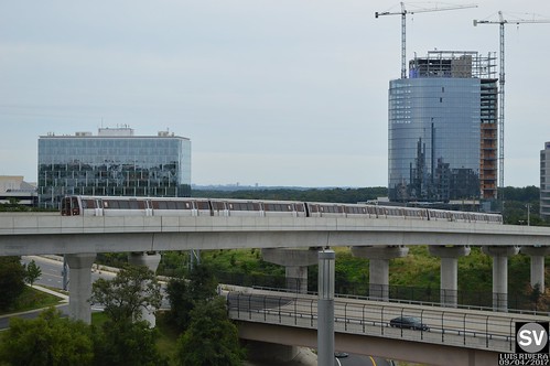
WMATA Mix Series Silver LineSilver Line in Fairfax County.

2. This would add six stations in Northern Virginia and service to a heavily used corridor.

For DC, it would add one crossing under the Potomac River, at least 9 new stations in DC, redundancy service for Downtown (and potentially 3-4 more stations if an additional Silver Line leg was constructed up Bladensburg Road).

It would serve key activity centers not currently served in Virginia (Arlington Boulevard/Seven Corners) and DC (Georgetown especially), providing additional capacity Downtown and at Union Station, which will be needed to service Amtrak expansion of Union Station.

3.  Paul indicated 8 Silver Line stations in DC.  I would say a ninth should be added at Connecticut Avenue, to connect (indirectly) to the Red Line.  I wouldn't provide a Red Line platform, because the station would be so close to both Farragut North and Dupont Circle.  Instead underground walkways could connect the Separated Silver Line to those stations.

4. In the vicinity of RFK Stadium, (and presuming the truncation of the Blue Line, see below) I would route the Separated Silver Line onto the Blue Line alignment from RFK Stadium to Largo Town Center.  That would put the new Oklahoma Avenue Station on the Silver Line.

5. At RFK, (presuming the truncation of the Blue Line) the Orange Line alignment would remain the same from Vienna to New Carrollton. But by crossing the Silver Line at this point, this would be a transfer point between the two lines, just as it is currently.

The Oklahoma Avenue station, at the western edge of the RFK site, was the only station in the original plan that ended up not being built, in face of neighborhood opposition fearing the station would be the equivalent of a "park and ride."

Rather than the aerial alignment from RFK Station to Minnesota Avenue for the Orange Line, it would be replaced by a tunnelized alignment.

The cost would be justified economically by the ability to enable superior redevelopment of the RFK Stadium site.

… speaking of lack of vision, "Mendelson aims to block DC from purchasing RFK stadium site," Washington Business Journal.  

6. Not indicated on the Meissner-Layman map, an infill Orange Line station could be built at the old Pepco generating site, providing additional service for the RFK area on the northeast.  This would be a 10th station for DC deriving from a "Separated Silver Line"."

(Controversially, because the Park Service has more golf courses than demand, the Langston Golf Course could be redeveloped.  Although the course is particularly important to local African[-American history and likely such a move would be opposed, and would also require approval of Congress and the Executive Branch, separate from the RFK situation, which is equally complicated.)

7. The proposed separate intra-city leg along Bladensburg Road from H Street to New York Avenue and Fort Lincoln could be extended further into Prince George's County if Maryland is interested.

This would provide Metrorail service to the New York Avenue corridor, if somewhat circuitous, and could also connect to a new infill New York Avenue station on the MARC passenger rail system ("One big idea: Getting MARC and Metrorail to integrate fares, stations, and marketing systems, using London Overground as an example," 2015).

DC economic development benefits.  As mentioned, the economic development benefits for DC of a Separated Silver Line would be incredible, especially if the Height Limit were tweaked.  But even if not, offhand I see incredible potential.

Central DC.  First, it would strengthen Georgetown so it can remain competitive as a regional entertainment and retail destination (starting a couple blocks up from M Street, Wisconsin Avenue's retail offer is weak)--although it would obviate the need for a gondola connection between Rosslyn station and DC.  Second, it would help Golden Triangle and Dupont Circle for both office and multiunit residential.  It would allow for intensification around Mount Vernon Triangle.  It would provide additional service to a growing Union Station.

Eastern DC.  It would add Metrorail service to the H Street corridor, one of the city's hottest entertainment districts.  It would provide the ability to do world class redevelopment of the RFK Campus, would revive and drive interest in the Minnesota Avenue-Benning Road corridor and Ward 7, and would move the redevelopment of the Pepco site forward.

Similarly, if a secondary Silver Line leg went up Bladensburg Road, the same thing, especially at the intersection of New York Avenue, which is grim now but full of potential.  It could also provide the impetus for additional development and necessary redevelopment at Fort Lincoln (although so many of the buildings are tied up as condominiums).

And if people would make the hard choice about Langston Golf Course, something no one seems to be willing to come out for ("The Langston Initiative: A New Vision for the District's Public Golf Courses," DC Federal City Council), that would be great too, although would come at the loss of some underutilized open space.

But it should be acknowledged that demand for golf courses has been dropping for some time ("Golf's challenges have country clubs in the rough. Here's how courses are fairing in the U.S.," Sports Business; "The Decline of Golf in 2018 – The Perfect Storm Continues For Most Golf Clubs," Golf Operator Magazine; "Dead Golf Courses Are the New NIMBY Battlefield," CityLab).

All told, this addition to economic capacity for the city, along with the improvement to the city's transit system and the addition of 10 new stations in DC (+ 6 in Northern Virginia) ought to make this a no brainer.

=======
Orange and Blue Line changes

The Meissner-Layman conceptual map proposes extending the Orange Line on both ends, in Virginia and Maryland.  Note that the I-66 toll concession agreement puts a time delay on possible Orange Line extensions westward.

Also, Paul and I "tussled" over ideas for the Blue Line ("Update to the Paul J. Meissner produced integrated high capacity transit map for the Washington metropolitan area," 2017).

 I wanted to end it in Rosslyn/Georgetown.  He came up with a separate Pink Line to serve the Columbia Pike corridor as well as continued it into DC and Maryland.  After he was done "designing," I realized that my truncated Blue Line could be joined with his Pink Line.

While it's true that people don't like transferring, and research finds that transfers decrease ridership, at the same time research finds that if service is frequent and transfer connections are reliable, people can deal.

Otherwise, the Blue and Orange Lines would remain interlined.

Or given the change in service on the Yellow Line, which will now go to Greenbelt all the time, again, the Blue Line could truncate and end in Rosslyn, and people could either transfer to the Orange line there for service to Northern Virginia or DC, to the Yellow Line to get into DC, or at a new Separated Silver Line to either Virginia or DC.

==========
This is also an example of what I call Transformational Projects Action Planning.

Vision plans to accomplish quantum change: Transformational Projects Action Planning.  Separately, over time, I've developed an approach to master or comprehensive planning that I now call transformational projects action planning. As part of master plans, I propose setting up a key set of big projects to focus on, projects with multiplicative and scalar benefits.
These are the most recent expressions:

-- "(Big Hairy) Projects Action Plan(s) as an element of Comprehensive/Master Plans," 2017
-- "Why can't the "Bilbao Effect" be reproduced? | Bilbao as an example of Transformational Projects Action Planning," 2017
-- "Downtown Edmonton cultural facilities development as an example of "Transformational Projects Action Planning" 2018
-- "Minneapolis Super Bowl: Urban Revitalization and Transformational Projects Action Planning," 2018

The basic idea is that a master plan should include a set of big, hairy audacious projects (like "big hairy audacious goals") to spur revitalization and community improvement in a substantive way.
TPAPs should be implemented at multiple scales:

(1) city/county wide as part of a master plan;

(2) within functional elements of a master plan such as transportation, housing, or economic development; and

(3) within a specific project (e.g., how do we make this particular library or transit station or park or neighborhood "great"?).

Labels: , , , , ,

Wednesday, November 02, 2016

More on Redundancy, engineered resilience, and subway systems: Metrorail failures will increase without adding capacity in the core

In response to the calls for more transparency from WMATA about why they want to reduce the service hours the system operates in order to have more time for maintenance (see "Re: Docket B16-03, Proposed changes to Metrorail operating hours," October 2016), WMATA did an interview with Greater Greater Washington ("Metro is being more transparent (and persuasive) about late-night closures... and weekend track work"). In response to the article and people's comments, which generally, are skeptical because they wonder why WMATA needs so much more time than peer systems, I wrote some comments myself (edited).

First, interestingly, the Bay Area Rapid Transit system is going through the same problems with significant financial needs for maintenance. They already have local sales taxes for transit, something not the case for WMATA. On next week's ballot in SF is Measure RR, which calls for spending $3.5 Billion on infrastructure improvement--for fixing only, not expansion ("Measure RR: BART asks voters to fund a major rebuild, KALW-FM/NPR).

Separately the MUNI system, which only serves San Francisco (BART does provide some intra-city service, but more functions like a commuter railroad) has two propositions on the ballot for system improvement there ("2016 Transit Propositions," SF Transit Riders Union).

It's instructive and relevant to our situation (as are the problems at MBTA).

2. People discussed the four tracks in NYC's subway system, some argued that it is for capacity not redundancy. But regardless, redundancy is provided by additional tracks. They also use the extra tracks for dealing with problems, which WMATA can't do because they don't have the option. No one in the NYC Subway system would argue that the additional tracks don't provide redundancy as well as more capacity.

Also inter-connections between NYC subway lines provide alternatives and capacity and redundancy as well. WMATA can't really benefit from such connections because in most cases the lines aren't proximate--it wouldn't help to shift riders to another line in the WMATA system for the most part because they would be delivered to stations many miles away from where they intended to go.

3. I've argued many times that additional tracks, even one, would provide redundancy and the ability to "staunch" service problems instead of spread them like a virus.

The same goes with interlining. Interlining between the blue, orange, silver, green and yellow spreads out problems across lines, it doesn't contain them.

I do think the points people made about separating lines (now I would do it with yellow and silver for sure, blue by continuing from Rosslyn and up Wisconsin Ave., and some branches such as for the green line) are important because long term it will provide more service, more uptime, and more reliability given the reality that no system can be maintained to the level of 100% SGR, especially because as trains age, they break down more.

All these issues were discussed in "More on Redundancy, engineered resilience, and subway systems: Metrorail failures will increase without adding capacity in the core," in March 2016.

4. As pointed out by others, London't Crossrail program doesn't really improve the Underground, theoretically, because it is a railroad program, but in reality it does, big time. It provides another mode, more connections, more capacity, just as repositioning these intra-metropolitan railroad services as complementary to the Underground by branding them as "London Overground" made the transit system more robust ("One big idea: Getting MARC and Metrorail to integrate fares, stations, and marketing systems, using London Overground as an example," May 2015).

MARC and VRE have more opportunity to play this role than they do currently. E.g., the Brunswick Line could provide bidirectional service and more service during the day were it used to shift travel between DC, Montgomery and Frederick Counties in both directions. VRE could provide more train service in the I-95 corridor.

5. I also argue that the Purple Line, not as big a deal as Crossrail sure, but it will have similar positive effects on Metrorail too, in terms of adding capacity indirectly, by providing options to transfer between subway and rail lines in the suburbs rather than forcing people to go to the center city first ("Maybe the Purple Line light rail project in Suburban Maryland is a lot bigger deal than is recognized (It's our Crossrail)," October 2016).

Expanding the Purple Line beyond the current project into Virginia will only strengthen these effects.

=================
Further refinements to creating separated subway lines for Metrorail

In "More on Redundancy, engineered resilience, and subway systems: Metrorail failures will increase without adding capacity in the core" I discussed a number of ideas for separating the lines.  I have a couple more refinements and additions.  Below is the same section from the original piece, but with edits and expansions.

Extension vs. intensification.  We need to distinguish between extending the system outward, or intensifying the system by adding capacity in the core, because these types of extensions have different impact.  It's the type of expansion that matters, not expansion generally.

Adding capacity in the core improves reliability while extending service outward, especially without increasing core capacity, degrades service.  Eliminating expansion in general limits the opportunity to improve system reliability.

Note that in some instances, system extension serves important purposes (e.g., such as to Fair Oaks in Fairfax County, extending the Orange Line, or to Fort Belvoir, which could be reached by extending the Yellow Line) but it shouldn't occur without simultaneously addressing how extension impacts the core system.

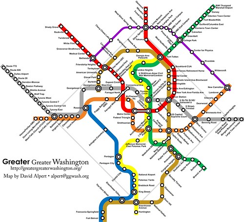
Conclusion: One of the best ways to improve reliability and safety in the Metrorail system is to create the Separated Silver Line within DC.   Sadly, this is where my lack of ability with graphic design software shows.  Many years ago David Alpert of Greater Greater Washington was kind enough to create a graphic of an idealized Metrorail system based on my thinking at that time.
Conceptual map for transit expansion in the DC region with a focus on subway service expansion within the District of Columbia.

But my thinking has continued to evolve and this is what I would propose now:

Separated Silver Line and Separated Orange Line

1.  Instead of what used to be called the separated Blue Line, I would now term it a separated Silver Line.  It could also be thought of as a "Downtown Relief Line."

Instead of joining the Orange Line at East Falls Church Station, instead treating it as a transfer station, the Silver Line could continue south to Route 50/Arlington Boulevard then east to Rosslyn, crossing to Georgetown, continuing eastward to Union Station (this adds capacity to serve Amtrak's plans for expansion), and then further east to H Street NE.  (The Arlington Boulevard alignment was suggested by commenter Ryan in a thread at GGW.)

2.  This would add stations in Northern Virginia and DC.  At the very least it would add one crossing and at least 9 new stations in DC, with 3-4 more stations if an additional Silver Line leg was constructed up Bladensburg Avenue.  It would serve key activity centers not currently served in Virginia (Arlington Boulevard/Seven Corners) and DC (Georgetown especially), providing additional capacity Downtown and at Union Station.

3.  The map above shows a separated silver line and a separated orange line with a transfer station at "River Terrace"/in the vicinity of RFK Stadium, I would route the Separated Silver Line onto the Blue Line alignment from RFK Stadium to New Carrollton (this is a change) and keep the current Orange Line routing.  This would allow transfers between the two lines.

4.  A separate intra-city leg of the Silver Line could be added along Bladensburg Road from H Street to New York Avenue and Fort Lincoln.

5.  The current bridge alignment of the Orange Line from Stadium-Armory over the parking lots to the Minnesota Avenue station would be eliminated, replaced by a tunnelized alignment along Benning Road from H Street and Bladensburg.  This would enable superior redevelopment of the RFK Stadium site.

Separated Blue Line/Brown Line

1.  The map above shows a truncated Blue Line ending in Rosslyn, and a "Brown Line" starting in Georgetown, extending south to National Harbor in Prince George's County and then west to Alexandria.

2.  I would merge the two lines so that the Blue Line continues from Rosslyn across to Georgetown and then up Wisconsin Avenue, connecting to the western leg of the Red Line, and turning east at some point in Upper Northwest, providing an east-west high capacity transit connection in the upper city.

3.  The Brown Line concept merges some of my ideas with Internet blogger MV Jantzen.  While the map above shows a southern alignment along North Capitol Street to Union Station and south into Prince George's County and then west to Alexandria, now I would probably have it go out New Hampshire Avenue into Montgomery and Prince George's Counties.  Before I thought that could be a more western leg of a separated Green Line.  It would have a transfer connection at Fort Totten.

The DC justification of extension out New Hampshire Avenue is to interdict commuter traffic to and from DC.  Montgomery and Prince George's Counties would see additional intensification benefits as well as an additional Metrorail connection to the Purple Line at University Boulevard.

4.  This would add a number of stations within DC serving areas currently not served by high capacity transit, plus an east-west connection in Upper Northwest, which has only one major east-west connection currently (Military Road-Missouri Avenue-Riggs Road).

Separated Green Line

Some of the visualization is difficult because I don't have a map of all these ideas.  The map that David Alpert did shows a brown line.  Now I suggest that the blue and brown line be combined, and the blue line should continue across the Potomac River to Georgetown and up Wisconsin, turning east and some point and providing an east-west connection across Upper Northwest Washington, connecting the east and west legs of the Red Line, plus the option of continuation out New Hampshire Avenue.

1. The Green Line could be separated and merely limited to its current footprint, without sharing stations with the yellow line.

2.  Alternatively, on the southern end it could be extended from its terminus at Branch Avenue to National Harbor and then across to Alexandria.  This change would serve National Harbor, one of the area's leading new activity centers in Prince George's County, and would provide more transit stations in Prince George's County and an east-west connection to Alexandria, Virginia.

3.  However, extending the Purple Line from New Carrollton to Alexandria with a connection to National Harbor could do the same thing and that probably makes more sense financially.

MetroForward 2040 Network concept map, WMATA.  I am not a fan of this proposal for a 
new 2040 Metrorail Network because it doesn't add service east of Union Station.

Separated Yellow Line

A separated Yellow Line within DC was first proposed in a blog entry by Dave Murphy and it could be extended to Montgomery County.

At first I wasn't supportive because of the low density nature of Georgia Avenue within DC, but long term the zoning could be changed and the area intensified, justifying the cost of creating a Metrorail line there.

1.  DC north.  Within DC, from the 7th Street-Shaw station the line could go north on Georgia Avenue from Howard University and extend outward into Montgomery County, either along Colesville Road or Georgia Avenue.

2.  Connecticut Avenue leg.  Based on a comment by Tom Quinn in the original post about the need for higher capacity transit service in the Connecticut Avenue corridor, in part as a way to interdict the heavy commuting traffic from Maryland, perhaps on the north a separated yellow line could have two branches.

In addition to the leg proposed above, extended in Montgomery County out either Georgia Avenue or Colesville Road, another leg could go up Connecticut Avenue, providing high capacity transit service in between the Wisconsin/Rockville Pike and Georgia Avenue corridors.

Benefits.  By separating the Silver and Orange Lines, each line would have the maximum capacity for 30 trains/hour, which is more than can be accommodated sharing the lines currently.  At least one additional crossing between Rosslyn and DC would be added.

Many more stations would be added in DC, as well as redundancy and more capacity in the core, increasing system reliability.  New areas would be served in all three jurisdictions, increasingly the ability to capture automobile trips and shift them to transit.

Note that adding legs, such as up Bladensburg Road on a separated Silver Line or both up Georgia Avenue and Connecticut Avenue on a separated Yellow Line would reduce capacity from the theoretical maximum because of time required to switch from the branch to the main line.  But there would still be more service and more reliability compared to how interlining works now.

A new alignment for a Blue Line across the Potomac and out Wisconsin Avenue would add service to areas underserved by high capacity lines now, a crucial east-west connection in Upper Northwest, and would add redundancy to the Red Line.  Extending the out New Hampshire Avenue into Maryland would add service there as well as enable the interdiction of commuter traffic into DC.

A separated Yellow Line extended on the south would add service to important parts of Virginia.  On the north, new alignments into two legs would provide service out Connecticut Avenue and Georgia Avenue in DC and on either Georgia Avenue or Colesville Road in Maryland as well as Connecticut Avenue.  (In fact, a Connecticut Avenue leg would probably mean that extending the east leg in Montgomery ought to be out Colesville Road.)

Extending the Purple Line on the south west from New Carrollton to Alexandria would provide other redundancy and access benefits, and provide a higher capacity transit connection to National Harbor which will soon be home to an MGM Casino and hotel complex.

Paying for it.  As I have discussed before, by increasing the allowable height at which buildings can be constructed in Downtown, DC's property tax base would increase significantly and become large enough to fund this kind of bold expansion and intensification of the transit system within DC.

Ideally, a "transit withholding payroll tax" could also be assessed, but for this to be worthwhile, the the federal government has to be willing to pay it (unlikely in the current economic environment), therefore this revenue source may not be worth pursuing.  In the US, certain jurisdictions in Oregon and in Greater New York have such a tax.  In France, this type of tax, called the versement transport, provides a preponderance of funding for transit service in most cities.

Funding for additions within Maryland and Virginia would be provided by those jurisdictions. But planning, design, engineering, construction, and financing should be coordinated, rather than discoordinated, as occurs at present.

=====
Purple Line impact on Metrorail system reliability.  The Purple Line will be a light rail line serving Montgomery and Prince George's Counties in Suburban Maryland.  Its western terminus will be at Bethesda Station on the western leg of the Red Line, and it will connect to the Red Line western leg at Silver Spring, to the Green Line at College Park, and to the Orange Line at New Carrollton, which is the eastern terminus for the line.
Purple Line Map  DC Metro
The original concept of the Purple Line.

The system won't interline with Metrorail so it won't impact system reliability in the way that the addition of the Silver Line has degraded service on the Orange and Blue Lines.

You could argue that by adding riders to the current system, it could add stress because of the failure to add capacity in the core.

However, by providing a missing east-west connection between the subway lines outside of Downtown DC, likely the Purple Line will "add capacity" by providing four new transfer points between subway lines, facilitating transfer between lines without requiring riders to go all the way to Downtown DC to do so, as is required today.
Purple Line routing and station map

Labels: , , , ,