Rebuilding Place in the Urban Space

"A community’s physical form, rather than its land uses, is its most intrinsic and enduring characteristic." [Katz, EPA] This blog focuses on place and placemaking and all that makes it work--historic preservation, urban design, transportation, asset-based community development, arts & cultural development, commercial district revitalization, tourism & destination development, and quality of life advocacy--along with doses of civic engagement and good governance watchdogging.

Friday, June 05, 2026

National Trails Day: Saturday June 6th

The first Saturday of June is National Trails Day.  I think that it should be leveraged to promote trail use, volunteerism wrt cleanups, as a day to celebrate opening new trails, facilities, etc. ("Thousands of volunteers help maintain WA trails each year," Seattle Times).  

Too often it isn't.

The American Hiking Society is the lead, but federal agencies, at least they used to, like the National Park Service and the US Forest Service were big celebrants.  

Biking and walking access is a big part of trails and Trails Day events.

US Forest Service lands are free access on Trails Day.  They have a lot of volunteer and other events that day, all over the country.

National Parks aren't free that day.

1.  Last month, while doing park playground evaluation for a grant application, I realized besides most places not having enough signage calling attention to trails, that trail signage could be augmented with information/icons pointing people to nearby services like restrooms or air pumps--bike maps often do this, but not signs.

-- "May is National Bicycle Month | More on the concept of adding services icons to bicycle route wayfinding signage"

2.  Years ago, I was blown away by a trail study for Cuyahoga County (Cleveland) Ohio (Cuyahoga Greenways Plan) that did demographic studies about the increased range of jobs made available through the expansion of trail networks.  

I haven't stayed in close touch with bike planning best practice over the past few years, but I think this plan is definitely worth reading in terms of how it lays out goals and evaluation criteria for route selection, and even branding!


3. The basic idea is building a network for cycling.  I like the way an old German National Bicycle Plan illustrated the point.


I'm still proud of the concepts I developed many years ago in creating the Western Baltimore County Pedestrian and Bicycle Access Plan in terms of the scales at which to focus the development of bicycle and walking infrastructure ("Extending the "Signature Streets" concept to "Signature Streets and Spaces""):
  • within neighborhoods
  • one mile radius from schools and bus stops and transit stations
  • three mile radius from "town centers"
  • along corridors
  • between corridors
  • connections within and to parks, which I called a County bikeway network
  • connections to neighboring jurisdictions (Baltimore County has borders with Baltimore City, Anne Arundel County, Howard County, Carroll County and Harford County in Maryland, and York County in Pennsylvania.
4.  With regard to trails as networks and infrastructure, urban trails can be particularly good at connecting neighborhoods to parks, libraries, shopping districts, grocery stores, schools and other civic assets.  The Northwest Branch Trail in Prince George's County does this very well--and it's the first trail that I really rode on that made me realize the value of trails versus street riding.

On the street, so much of your mental energy is occupied on defensive cycling.  You can drop a lot of that when riding trails, except for gauging the movement of pedestrians, little kids, dogs, roller bladers, scooter riders, skateboarders, etc.

On the Baltimore and Annapolis Trail and the Indianapolis Cultural Trail, brewpubs in Iowa, etc. many businesses have opened rear entries to link to the adjoining trail.

The patio and 606 Trail access point at Wolf & Company in Bucktown. Credit: Quinn Myers/Block Club Chicago.

In Chicago, the Wolf and Company restaurant is the first company to have placed a restaurant entry on  the 606 Trail.  

They specifically chose that building because it could support multiple concepts, including the trail.

Ironically, the 606 Trail was created to serve a lower income area of Chicago ("Lessons from The 606," DePaul University Institute of Housing Studies) but the Bucktown neighborhood where the restaurant is, is decidedly upscale.

The top floor is a cafe with coffee, tea and other drinks.

The bottom floor, 1752 N. Western Avenue opens to the street and neighborhood, with a full service restaurant, bar and market ("Bloomingdale Trotters Should Beware of Wolves, Not Foxes, Along the 606," Eater).

With a butcher case like this, and prices to match, the market is definitely a lot more than a typical convenience store focused on selling snacks and soda.

So Wolf & Company is three concepts: cafe; restaurant and bar; and upscale market, in one, connecting both to the 606 Trail and the Bucktown neighborhood.

5.  Speaking of branding, how about Promoting Bikeway Networks through Postcards?  The Alta Trail Map postcard below pictures their trails for winter skiing.  I like the icons they use to denote the various amenities at different trailheads.  Ski resorts promote mountain biking in summers as a way to build revenue off-season, and publish trail maps.


Relatedly, the Ketchum Idaho Visitor Center has trail maps posted on its walls.  As do some other groups.  But rarely bicycle shops.

6.  Not trails per se, but bikeways, Salt Lake is really doing a lot of great work ("Recent study cites Salt Lake City as one of the nation's safest metro areas for bicycling," Cache Valley Daily), even though its program to add sustainable mobility infrastructure to the city's streets has been stymied and preempted by the Utah State Legislature--legislators complain that bikeways make it hard for them to drive to the Capitol ("Utah Senate approves bill that blocks Salt Lake City's street improvement work," Salt Lake City Weekly).

7.  Besides the drying up of federal funding for sustainable mobility infrastructure ("Cities Losing Federal Support for Bike and Walking Infrastructure," Governing, "USDOT’s historic failure to advance any new transit projects in 14 months may be a sign of things to come," Transportation for America) and fortunately most states and localities are maintaining their commitments to biking and walking (and can't afford to cover federal government funding for transit) ... 

8.  the biggest issue in bicycle planning to me is not the development, construction and implementation of infrastructure and facilities, but providing the assistance people need to make the transition from automobile-centricity to biking.

I write about that here:

-- "Revisiting assistance programs to get people biking: 26 programs"

9.  Secure bicycle parking networks operating at the metropolitan scale.  But while #24 is Provision of secure bicycle parking, and lockers and showers in destination districts.  Zoning requirements to build them in office buildings and campuses of a certain size.  Or as a proffer/ community benefit.

I failed to call out specifically the need for secure bicycle parking networks.  That means 27 points.  This covers the topic:

-- "If you're going to promote electric bikes at scale, there needs to be complementary investment in secure bicycle parking and charging" (2023)
-- "Bike to Work Day as an opportunity to assess the state of bicycle planning: Part 2, building a network of bike facilities at the regional scale" (2017)

Rennes, France does a good job with regional secure bike parking ("National Bicycle Month | Rennes, France: a national model").  Other European cities too.

10.  E-bikes can help a lot.  Years ago I was critical about e-biking, because I thought "regular" bikes worked in cities--especially in flat areas--just fine ("(Still) tired of mis-understanding of the potential for e-bikes."

E-bikes have the added benefit of 

  1. extending the distance people are willing to commute by bike
  2. making it easier for aging seniors to continue biking
  3. making it easier to bike in hilly conditions
  4. making a bicycle trip more competitive with car travel in terms of time, so that people actually switch trips from a car to a bike.

From Reddit. An Amazon e-bike vehicle making deliveries in DC.  Although some worry about such vehicles blocking bike lanes. 

11.  Making cycling irresistible. But my earlier position on "the right way to use electric bikes" made me remember job isn't to make plans about how I think people should bike.  It should be about building the conditions to make bicycling irresistible 

-- "Making Cycling Irresistible: Lessons from The Netherlands, Denmark and Germany," Transport Reviews (2008).  

I used that paper as the foundation for this piece, which was commissioned at the time by the DC Bicycle Advisory Committee in response to a Rails to Trails Conservancy initiative.   

-- "Ideas for making bicycling irresistible in Washington DC" (2008)  

In writing, I made the point that DC is urban and should lay out an urban agenda for biking, as opposed to the more suburban and rural biking "sense" of the rails to trails movement.

I see one of the ideas, delivery services using bike-based vehicles is just now being implemented in DC.

12.  E-bikes and cargo bikes help people shift trips to and from school from car to bike. ("Small But Mighty: Electric Bicycles Can Bridge the Gap in Access to Transportation," National Laboratory of the Rockies, "Study finds that once people use cargo bikes, they like their cars much less," ArsTechnica).

13.  E-bike voucher programs are quick to fill up.  I didn't even know about the latest one in Utah ("Utah E-Bike Program offers $800 vouchers to qualified residents," ABC4).  It opened on June 1st.  Was full before the end of the day on June 3rd.

I like the usually these programs provide more support for those of lesser means.  But I think that they should be loan deductible programs like in in England or Ireland.   Sometimes, they are funded through carbon tax programs and similar kinds of impact fees.

14.  E-bikes on trails (and beaches) can be problematic.  On trails it is because they are faster than people on foot or regular bike.  And certain types of e-vehicles aren't bicycles, but more akin to motorcycles ("Iowa City needs a nuanced conversation about e-bikes," Iowa City Press-Citizen, "Iowa cities team up to promote e-bike safety on trails and sidewalks," Iowa Public Radio/NPR, "E-bikes are all over mountain trails. Some want them banned," "In the South Bay, e-bikes are restricted along the beach. Yet they’re still everywhere," Los Angeles Times, "Moab Opened 200 Miles of Trail to E-Bikes. I Was One of the First to Ride Them (Legally)," Outside).  From the first article:
Anyone who regularly uses Iowa City trails has likely seen the tension already developing: riders moving too quickly through crowded pedestrian areas, oversized throttle-powered bikes built more like motorcycles than bicycles, and parents purchasing machines online without realizing they may exceed Iowa’s legal definition of an e-bike. 
A sign posted at a trail entrance to the Aliso Wood Canyon Wilderness Park 
in Aliso Viejo, California restricts e-bike usage.
That matters because Iowa City has spent decades building trails designed to function as shared public spaces. Pedestrians, runners, wheelchair users, cyclists and families with strollers all use the same network. That system works because speed differences remain relatively manageable and predictable. A 12 mph difference matters on a crowded trail. A 30 mph difference changes the character of a shared trail completely. 

Unfortunately, the public conversation often collapses into two extremes. Either all e-bikes are treated as dangerous, or any discussion of regulation is dismissed as anti-bike hysteria. Both reactions miss the point. Most e-bike riders are responsible, and many are exactly the kind of people cities should want out of cars and onto trails. E-bikes reduce traffic, parking demand, and transportation barriers for people who might not otherwise ride at all. At the same time, it is reasonable to acknowledge that high-speed electric motorcycles do not belong on crowded recreational paths simply because they have pedals attached.

Ketcham, Idaho.

15.  Suggestion: Create a senior bike purchase deduction program from the social security benefits program.  I recently suggested Medicare could do this for seniors ("The "new" Washington Post editorial page blows a chance to be innovative | Nudging versus "nannyism" and senior health care"), but instead of deducting from your payroll check, from your Social Security check.  

There is clear value for promoting senior biking as a fitness measure.  Let's make it easy.  People with lower incomes could get a match--the check doesn't go all that far for many and i can be difficult to save up for big expenditures.

16.  Speaking of seniors, we need to have programs that promote walking and biking as people age.  Some senior centers and organizations do this on a national best practice basis ("Freewheelers: Old Spokes Bicycle Club," Philadelphia Inquirer).  Apparently there is a similarly named Old Spokes group in Calgary.  

Baltimore County Office of Aging sponsors a Cycling Seniors program.  Etc.

A couple years ago, Washington Area Bicyclists Association did an active transportation expo for seniors.  

I think all senior center programs should develop and implement similar kinds of programs.

17.  Acknowledge and respond to climate change.  Trails should consider adding push button mister stations to deal with the heat.  

Water stations where they can be installed, based on access to utilities.

Add shade structures and tree plantings.  With the aim that over decades, the trees become tall enough to provide significant shade.

A mister on a playground.  


Labels: , , , , , , , , ,

Friday, January 23, 2026

National Park Service and climate change

The New York Times reports, "National Park Service Removes Sign on Climate Change From Fort Sumter," that the Trump Administration has removed a sign about climate change impacts at Fort Sumter, the site of the start of the US Civil War.

This is a result of both the desire to whitewash historic interpretation to avoid discussion of difficult histories, such as slavery and DEI, but also a directive saying climate change doesn't exist and change interpretation accordingly.

Based on possible negative impacts, federal agencies with large property portfolios, such as the Department of Defense, and the National Park Service, have devoted a lot of time and attention to planning for site futures in the face of climate change.

The Park Service has a number of resources. Even if taken down, they'd be available via archive.org


Labels: , ,

Wednesday, July 16, 2025

Coast-to-Coast High-Speed Rail Route Proposed Between Los Angeles and New York


Newsweek reports on the above proposal, submitted as a letter of inquiry to Amtrak by:

AmeriStarRail, a startup specializing in high-speed and intermodal passenger rail, pitched a partnership with Amtrak to launch the "Transcontinental Chief," a high-speed rail route that would run between Los Angeles and New York in under 72 hours.

I have written up similar ideas in the past.  

The thing is now I am convinced, from the 'why can't we have nice things' department that because Republicans don't believe in the concepts of public goods, public investment, and climate change, that something like this won't ever happen in my lifetime ("Trump administration pulls billions in funding for high-speed rail project; state leaders call decision ‘illegal’," Los Angeles Times, "Train linking Twin Cities, Duluth in doubt as D.C. Republicans try to yank money for passenger rail," Minneapolis Star-Tribune, "'Derailed' tells the story of the Wisconsin high-speed rail line that wasn't," The Capital Times).

Plus, HSR makes more sense for shorter trips, like DC to Boston, not New York City to Los Angeles.  There are other issues too ("Whither (wither) high-speed rail?," "California HSR: Seven Deadly Mistake," Railway Age).

Plus I think we need to think about this in terms of the major nodes on this line in turn supporting the development of robust regional rail services, along the lines of what I suggested here:

-- "Two train/regional transit ideas: Part 1 | Amtrak should acquire Greyhound," (2021), based on the organization and delivery of railroad passenger services in Japan.  And it should further include inter-city bus services where rail service is hindered.

That's in keeping with Amtrak ridership being focused in major corridors like DC to Boston or San Diego to Los Angeles.

Note that some people suggest that AmeriStarRail is merely an attempt to privatize Amtrak.

The new route would replace Amtrak's Southwest Chief and Pennsylvanian lines and rely on existing infrastructure from host railroads, including BNSF, Norfolk Southern and New Jersey Transit. 

Unlike past rail startups that have required federal funding, AmeriStarRail says its model is entirely privately funded. The company has presented the proposal to President Donald Trump, Secretary of Transportation Sean Duffy and members of Congress.

Note that a study of VIA Rail passenger services suggest that transcontinental trips by rail produce more GHG than air travel ("Why the train may not be the greenest way to travel across Canada," CBC-TV).  

So the focus in the US should be on replacing shorter distance air travel with the train.  Except competition and lobbying from airlines and airports--most publicly owned anyway.

Under the Biden Administration Amtrak and the Federal Railroad Administration produced a master plan for developing a more robust passenger system (MORE TRAINS. MORE CITIES. Better Service), based on the concept of focusing on regional/multi-state services.

=====

-- "Moving Forward—At Restricted Speed," Railway Age

Labels: , , , , , ,

Thursday, July 06, 2023

Building a statewide rail passenger program for Ilinois

I have written about how Pennsylvania with SEPTA, Massachusetts with MBTA, and Maryland with MARC ("A "Transformational Projects Action Plan" for a statewide passenger railroad program in Maryland," 2019) could use their regional railroad commuter systems as the foundation to develop statewide railroad passenger programs.  

Massachusetts has a big advantage because offshore wind power could be used to electrify the entire system.

I hadn't thought about it in terms of METRA and Illinois.  The State of Illinois just selected METRA as the operator, over Amtrak, to extend service from Elgin (the service emanates from Chicago) to Rockford ("Metra chosen to restore passenger rail to Rockford," Rockford Journal-Star).  Rockford is about 90 miles from Chicago.

Amtrak does provide service throughout Illinois, such as from Chicago to St. Louis, and Chicago to Milwaukee.

For thinking about how to organize railroad passenger service at multiple scales throughout the US, see:

-- "Two train/regional transit ideas: Part 1 | Amtrak should acquire Greyhound" (2021)

Labels: , , , , ,

Friday, October 14, 2022

Electric bicycles as a quantum opportunity for transportational cycling: can e bikes be conquest sales versus cars?

The US has a very homogeneous approach to land use and transportation planning.  It's not very open to heterogeneity in that everyone is supposed to rely on a car to get around, uses are supposed to be widely distant from each other, etc.  

A few of the legacy cities (New York City, Boston, Philadelphia, Chicago, San Francisco) are dominated by transit.  No city has the kind of bicycling for transportation penetration common in the Netherlands or Denmark.  No temperate city is dominated by mopeds.

By contrast, European cities prioritize transit (and biking and walking) in their cores, even if the nation (like Germany) is equally committed to roads and automobiles.  They support heterogeneity in mobility because they recognize different modes have a role to play depending on land use context.

Vespas riders in Rome.  Flickr photo by Tony GVK.

Some European cities, particularly in the warmer climes, are dominated by mopeds, that is scooters, which are a great way to get around without the bulk and other requirements of the car.  

You do see scooters in US cities and bicyclists and transit users, but in most instances (not New York City and transit) the mode users are outliers. There are a couple of people, not dozens or hundreds.

In the past I have been both positive and negative about the opportunities presented by electric bicycles.

-- "(Still) tired of mis-understanding of the potential for e-bikes," 2015

My complaint has been a focus by vendors on the core of center cities, which often are flat and the distances are short, plus the big mix of pedestrians, transit users, cyclists, and motor vehicles is complicated, and adding a powerful bicycle to the mix increases the speed differential with people on foot.  

In short, an e-bike at the core of most center cities is overkill.  Regular bikes are just fine.

On the other hand, for longer distance trips, for people as they age, and in topographically challenged areas, electric bikes offer advantages over traditional pedal-powered bikes (myself, I am hoping to make it til 65 or later before I convert, but I do live in a serious hilly area on the Wasatch Front).

Conquest sales: a term from the auto industry: My adoptive father worked for the auto industry, and they referred to "conquest sales" as those times when your make was newly successful in getting the owner of another make to buy your car, e.g., a Chrysler car is sold to someone who owned a Ford.

Can e-bikes become sustainable mobility conquests versus the car?

It will be hard, because our mobility system is set up for automobiles.  But even if 5% of automobile users could be converted to e-bike users, or at least to use an e-bike some of the time, it would have a significant impact on congestion, air quality, etc.

Tax credits for electric bikes.  Denver passed a sales tax to support sustainable mobility initiatives , called the Climate Protection Fund, and it includes a limited number of vouchers--400 per month, towards the purchase cost of an electric bicycle (" Denver’s E-Bike Rebates Are So Hot They’re Gone Within Minutes," Bloomberg).  From the article:

“We thought there would be some interest in owning e-bikes — we just had no idea it would be as popular as it has been,” Rink said. “For those of us who have made our careers in government and have tried to tell people about all the programs we have, we know it's hard to get the word out. This one wasn't hard. People jumped on it right away.”

The Radpower electric bicycle shop on 700 East in Salt Lake City sets up demonstration riding in their parking lot.

The rebate program offers Denverites between $400 and $1,700 off the purchase of an e-bike. It’s been so successful that the city is now increasingly being looked to as a model by the rest of the country as local communities take on more initiatives to reach net-zero emissions targets. 

Low income residents are eligible for the highest rebates.

Massachusetts is introducing a small rebate program.  And a handful of other communities besides Denver have similar programs.

Potential for abuse.  Although it's definitely ripe for abuse.  For example, the UK has a payroll deduction program for bikes, and many people use it to buy super expensive road bikes for recreational use, when the intent is that people use the bikes for transportational cycling.

It's not like people who are using the rebate in Denver have to get rid of cars to be eligible for the rebate.

Flickr photo by zakiakhamad.

Security issues and secure bicycle parking.  In my Reddit feed I'm presented with entries from r/Denver, and some of the newly purchased bikes have been stolen.  One commenter mentioned his heavy duty secure lock set up cost about $300.  

E-bikes, which cost so much more than hybrid bikes, have even greater need for the provision of secure bicycling parking. 

I've suggested that metropolitan areas could create a network of secure bicycle parking facilities, modeled after the Parkiteer system in Melbourne, Victoria State, Australia--Victoria State "invented" transportation demand management.

-- "Bike to Work Day as an opportunity to assess the state of bicycle planning: Part 2, building a network of bike facilities at the regional scale"

Bike gutter/bike trough on the Capital Crescent Trail in Bethesda, Maryland.

Urban design.  Electric bikes are heavier.  A lot of places don't install bike gutters as a matter of course on stairwells, etc.  They should.  They'll also have to be bigger/wider to accommodate larger bikes.

Labels: , , , ,

Tuesday, November 10, 2020

Glass buildings are bad for the environment, the use of energy and the generation of greenhouse gases

Buildings with curtain walls made of glass in Boston's Seaport District.  Photo: David L. Ryan.  

The Boston Globe has a nice article on this, "Boston wants to fight climate change. So why is every new building made of glass?."

From the article:

If architects, planners, and public officials in Boston mean everything they say about sustainability and climate readiness, why is the city’s latest construction boom filling the skyline with so much glass? From the shimmering height of the Millennium Tower to the waterfront views of 22 Liberty, and a boxy office and condo complex going up at Pier 4, glass exteriors have become a major feature of today’s urban landscape. Just as we associate periods in Boston’s history with specific materials and styles — like 19th-century brick apartment blocks and 20th-century monumental concrete forms — glass is the material of the moment. The new buildings mimic others being erected in New York, London, Dubai, Singapore, and other cities around the world. Glass walls have become a shortcut for architecture that is sleek, cosmopolitan, and of-the-moment.  .....  
Yet glass buildings also take a lot of energy to heat and cool. When New York started tracking energy use by skyscrapers, the gleaming 7 World Trade Center — one of that city’s more efficient glass towers — scored worse than the 1930s-era Empire State Building. Oddly, glass buildings are proliferating even as cities like Boston set ambitious goals to deal with climate change. Former mayor Thomas Menino vowed to cultivate “the most sustainable city in the United States”; his successor, Martin Walsh, has called Boston “America’s climate champion” and set a goal of being carbon neutral by 2050. ...  
But all the talk about sustainability among architects hasn’t actually translated into lots of sustainable buildings in the real world. In reality, the industry faces a massive problem: By some estimates, the building sector consumes nearly half of the energy and produces 45 percent of greenhouse gas emissions in the United States. Many architects have signed on to an industry challenge to become carbon neutral by 2030, but new buildings are already slipping behind the targets to get there. Permissive building codes, industry inertia, and market demands — like clients clamoring for floor-to-ceiling views — have widened the discrepancy between the kind of buildings cities say they want and what they actually allow. So while the industry inches towards better environmental performance, buildings in Boston and other cities still fall short of the sustainability goals that everyone claims to embrace.
On a number of issues--more to come--it's clear that the kinds of initiatives underway mostly in Europe:

are nowhere near being implemented in the US.  

Yes

but for the most part, substantive world changing initiatives by cities, counties, and states seem to be rare.

More big initiatives are being led by industry, especially in the (sustainable) energy sector (solar power, wind turbines), Elon Musk and Tesla have redefined the automobile industry in terms of the viability of electric cars, and there are significant increases in individual households installing solar electricity systems, although the decline of tax incentives and industry push back on compensation rates could lead to a decline.

The biggest thing cities have been addressing are autonomous vehicles ("The 4 cities competing to fully implement autonomous vehicles," Electronic Engineering Times), and while they can reduce accident, injury and death rates compared to people-operated vehicles, they aren't an environmental initiative.

Labels: , , ,

Monday, May 04, 2020

New legal brief outlines how America’s historic places are at risk from climate change | May is National Historic Preservation Month

This is a reprint of a press release (sent April 27th) from Environment America:
Environment America and the National Trust for Historic Preservation filed an amicus brief in support of a lawsuit challenging the Affordable Clean Energy Rule, a new set of regulations created by the Trump administration. Unless defeated in court, this plan will sharply increase U.S. greenhouse gas emissions driving global warming, which, among other impacts, will spur a tremendous rise in sea levels.

The amicus brief highlights risks created by climate change to four of our country’s most historic cities and national landmarks: Annapolis, Maryland; Charleston, South Carolina; Ellis Island and the Statue of Liberty in New York City, New York; and St. Augustine, Florida. These endangered places are not alone. Almost half of all Congressional districts are located in threatened coastal areas, which could also see similar historic losses. Beyond sea level rise, extreme weather from climate change can lead to increased flooding and fires as well. These natural disasters may also cause irreparable destruction to our national heritage in inland locations.

Water fills the east end of Thames Street in Fells Point after Monday morning’s storm. (Jerry Jackson/The Baltimore Sun).

“Historic landmarks and communities throughout the United States are threatened by climate change, and these irreplaceable sites provide us with an essential understanding of who we are,” said Thompson M. Mayes, chief legal officer and general counsel of the National Trust for Historic Preservation, “This brief aims to express just how dangerous EPA’s weakened regulations on global warming could be to our shared sense of history.”

The brief argues that the Environmental Protection Agency drafted the Affordable Clean Energy Rule without adequately considering its impact to historic resources and communities. Already, seas are expected to rise as much as four feet by the end of this century, according to the National Climate Assessment. In addition, climate change’s impact on heightening the intensity of flooding, storms and fires will further exacerbate this problem. 
Howard Rogers walks through a flooded street during the king tides of September 2015. (Photo: Joe Raedle/Getty)

Ultimately, every American should ask this question: Can we continue to ignore the climate crisis and risk a watery demise for our historic coastal communities, or will we give our most beloved cities and towns a fighting chance to stay above water?” McGimsey said.

Labels: , , , , ,

Sunday, April 05, 2020

What about solar panel shingles as a solution for historic houses and historic districts? Tesla's new option is transformational -- more attractive, more efficient

This bungalow on Van Buren Street NW has solar panels on the front of the house, but I think it lies outside of the Takoma Historic District.

I've written a number of posts over the years about the issue of solar panels and the diminishment of architectural character when such panels are placed on the front-facing pitched roofs of historic houses.

-- "Solar panels and historic districts: not a simple decision," 2012
-- "Solar energy and the city: more issues," 2015

As mentioned in a previous entry, this has come up recently with "controversy" stirred up by the Greater Greater Washington blog about pretty egregious looking solar panels on a house in the Takoma district of DC ("DC will now allow solar panels in historic districts! (Mostly").

On the right is the original proposal.  On the left is what was approved in a compromise, by enclosing the panels in a sleeve.  It's still pretty bad, imo anyway.

In keeping with the legal rostrum that "hard cases make bad law," the fact is that most houses in DC historic districts have flat roofs so negative design impacts are rarely an issue, and the proposal was pretty butt ugly, which the various reporting and opinion pieces refused to acknowledge ("When Historic Preservation Hurts Cities," New York Times).

Granted, it was climate change activists that were opposed to the original decision, arguing that design integrity matters less given the state of the climate change problem ("When saving the planet spoils the charm of historic houses," Washington Post).

Even the director of DC's Department of the Environment and Energy criticized the original decision.

This is disappointing because there is a simple solution, one that the DC government could spur through design and other technical and financial assistance.

For years, I've been holding out for solar shingles. 

The technology has been around for awhile but was costly and not as efficient.

But apparently now Tesla has high performing solar shingles that outperform traditional panel installations ("Are Tesla solar roof tiles worth it?," GES Solar Energy Systems Magazine; "Tesla Solar Roof installations appearing in the wild," PV Magazine).

-- Tesla Solar Roof

And Tesla's solar tiles have been in production since 2018, long before the October 2019 Historic Preservation Review Board that got the bloggers and ANC Commissioners all worked up.

They aren't cheap. But presumably the cost will decline over time.

And they have a 98% efficiency rating, which makes them more cost effective compared to traditional solar panels, which range in efficiency from 14% to 23%.

According to the Tesla, the cost of solar tiles is $1.99 per watt generated, which is less than the $2.99 per watt cost of traditional panel-based systems ("Tesla Solar Roof: Elon Musk’s solar roof tiles complete review (V3)," EnergySage).

So the question should be moot.

Design quality doesn't need to be sacrificed on the altar of climate change activism.  Just use solar tiles.

Instead of criticizing HPRB, I wish that the director of DC DOEE would have facilitated a special demonstration project by Tesla, involving the Historic Preservation Office of the Office of Planning and the Department of Environment and Energy.

(Because of the high efficiency, Tesla recommends that only 30% to 40% of the total number of roof tiles be solar, with the others non-solar.  Tax credits only cover the solar-based tiles.)

Labels: , , , , ,

Friday, February 21, 2020

A "Transformational Projects Action Plan" for the Metrorail Blue Line

This piece is sparked by today's Post article, "Metro Blue Line extension into Prince William? Virginia lawmakers want a study," where Virginia legislators are looking to appropriate $2 million to study the extension of the Blue Line from Springfield in Fairfax County to Quantico in Prince William County.

Proposal:

1.  Go along with Virginia legislators desire to extend the Blue Line to Quantico, even though this is normally too long a distance for heavy rail.

In return for:

2.  Accelerating the creation of a second tunnel at Rosslyn crossing into DC; and

3.  Leveraging the project to create a Separated Blue Line in DC, resurrecting a long abandoned plan that was raised in 2001 and scuttled in 2003.  This would provide service to Georgetown and along M Street, another subway connection at Union Station, and service to H Street NE.

And doing it starting "now" not in 10 years...


Circa 2001 Metrorail expansion planning.  I have written many times of the old plan to build a "separated Blue Line" WMATA Metrorail line.

This would have created a second crossing under the Potomac River at Rosslyn and continued into Georgetown, perhaps along M Street to Union Station and then further east along H Street NE.

When this graphic accompanied a Washington Post article ("Crowds Could Derail Decades of Progress," 3/25/2001) about the proposal, just as a group of us were working on H Street revitalization matters, it was electrifying.
Proposed changes for the WMATA system, 2001 (separated blue line)

2003 Recession: WMATA drops expansion plans.  But in 2003, during a recessionary period for Greater Washington, WMATA dropped expansion planning in its entirety ("Metro Construction Projects Creak to Halt; Economic, Political Changes Cancel Expansion Plans, Spur Job Cuts, Early Retirements," Lyndsey Layton. Washington Post, July 13, 2003. pg. C.01), deferring responsibility for expansion planning to the separate jurisdictions.

Silver Line planning not affected.  Virginia continued on with its planning for the Silver Line, which it was pursuing separately anyway.  Insanely, they were allowed to do so without having to pay for capacity expansions in the core.  They said it wasn't their responsibility, even though the expansion would challenge system equilibrium.
Routing map, Silver Line WMATA

Washington DC didn't take the opportunity to leverage the Silver Line as the way to create a separated blue line.  Only Arlington kept hopes alive for a separated blue line in its Master Transportation Plan.

I started writing about the likely problems from this in 2006.

-- "The "Downtown" Circulator and Rosslyn, Virginia," 2006
-- "Blinking on urban design means you limit your chance for success," 2006
-- "Winners and losers with the Dulles subway project," 2007
-- "Silver Line Metro expansion a classic example of the need to have true regional transportation planning," 2011
-- "Ultimately, WMATA blue line riders have been dissed by the State of Virginia, not WMATA," 2013
-- "The Silver Line WMATA story that WJLA-TV missed," 2014

Ten years later, WMATA starts expansion planning again.  With evident problems forecast concerning capacity in the core, WMATA has refocused on expansion planning.  They've gone through a couple iterations, one the Momentum plan ("Metro proposes $26 billion overhaul," Post, 2013), including more recent releases which I haven't written about.

The major element of the newest plan is to add a crossing at Rosslyn, which they hope to do by 2030 ("Metro Looks At Building New Lines To Address Tunnel Congestion, But What’s Realistic?," WAMU/NPR).

I've never been pleased with this planning program, because it satisficed proposals based on what they could get all jurisdictions to agree to, rather than advocating for the best outcomes.  It adds capacity within the current footprint but nothing beyond it.

We all know how the Silver Line worked out: badly.  The subway lines had already been stressed by failures in the signalling system, culminating in the Fort Totten crash in 2009, which killed 9 people.  But the addition of the Silver Line made things worse, crashing the system overall.

-- "Redundancy, engineered resilience, and subway systems: Metrorail failures will increase without adding capacity in the core," 2016

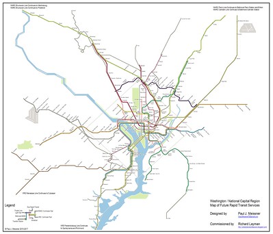
Fantasy planning and the Paul Meissner maps.  The redundancy post made many arguments, including the problems that result from "inter-lining," which rather than containing problems when they occur, spreads them to other lines.  It called for making many changes to the Metrorail system, focused on separating the lines.  The main concept was a separated Silver Line, instead of a separated blue line.

From that, I connected with a GGW reader and commenter, Paul Meissner, who agreed to create a couple maps, one showing the current rapid rail system, including railroad services, and an idealized fantasy map, based in part on previous plans and proposals.

Conceptual Future integrated rail transit service network for the Washington DC National Capitol Region. Design by Paul J. Meissner.  Concept by Richard Layman and Paul Meissner.

There was push and pull.  He was the graphic designer, which gave him  more say in the process (i.e., "possession is nine-tenths of the law") and output so the ideas were a mix from both of us and I had to compromise.

I've referenced the maps in a couple pieces, including:

-- "Setting the stage for the Purple Line light rail line to be an overwhelming success," 2017, a multi-part series
-- "Using the Silver Line as the priming event, what would a transit network improvement program look like for NoVA?," 2017

In the map development process, rather than suggesting an extension of the Blue Line, we proposed extending the Yellow Line, terminating at Fort Belvoir.  There, the idea was to capture and promote density along Route 1 and service to the military base, which was expanded as a part of the 2005 BRAC closure process.  To be frank, this should have happened as a result of that process, which I suggested back then.

A couple months after Paul finished the project, I realized we could have also proposed a separate Blue Line extension to Woodbridge and Dale City, not thinking about an extension as far as Quantico, which is almost 12 miles further.

Extension vs. intensification in transit planning. We need to distinguish between extending the system outward, or intensifying the system by adding capacity in the core, because these types of extensions have different impact. It's the type of expansion that matters, not expansion generally.

Adding capacity in the core improves reliability while extending service outward, especially without increasing core capacity, degrades service. Eliminating expansion in general limits the opportunity to improve system reliability.

Note that in some instances, system extension serves important purposes (e.g., such as to Fair Oaks in Fairfax County, extending the Orange Line, or to Fort Belvoir, which could be reached by extending the Yellow Line) but it shouldn't occur without simultaneously addressing how extension impacts the core system.

While normally I would argue that an extension of this length is nonsensical, it's worth considering if it can be leveraged to bring about the separated Blue Line in DC.

Transformational Projects Action Planning and the Blue Line.  TPAP is a concept I've developed which proposes to seed master plans with a set of anchor projects as the "transformational projects element" as a way to drive the plan forward in substantive, visionary, transformational, and beneficial ways ("A "Transformational Projects Action Plan" for a statewide passenger railroad program in Maryland" and "Why can't the "Bilbao Effect" be reproduced? | Bilbao as an example of Transformational Projects Action Planning").

I think that the Virginia legislative initiative ought to be leveraged to do three different things:

1.  Extend the Blue Line to Quantico (which will get support to do the two other elements).

2.  Add the second crossing at Rosslyn to Georgetown and the expanded transfer station.

3.  Create the separated Blue Line in DC, along the same lines as the original 2001 proposal, but with a couple twists.

-- The DC routing would add redundancy and capacity in the core, and provide a second subway connection to Union Station, which is necessary for support of railroad passenger expansion plans there.  At Mount Vernon Square it would provide another subway line connection to the proposed Maglev rail service.

-- It would add 8-10 new stations within DC, although the section between Georgetown and Mount Vernon Square is already pretty developed, so it wouldn't necessarily add a lot of new development capacity, which is the normal way to pay for the cost of such infrastructure expansions.

-- It would eliminate the need for a gondola transit connection between Rosslyn and Georgetown.

-- After Union Station the line should go out H Street, and then at Oklahoma Avenue, cross through the RFK campus, but underground, to RFK station and continue to the end of the line at Largo.

-- Undergrounding the lines here will add development capacity to the RFK campus.

-- The Orange/Silver Line would similarly go underground at RFK to pick up the current Orange Line routing from RFK to New Carrollton.

4.  This means no longer focusing on a separated Silver Line, but pairing the Silver and Orange Lines.  Frankly they could both be termed the Orange Line but with two branches.

-- Virginia should also consider an extension of the Orange Line from Vienna to Centreville as outlined in the Meissner map above.

5.  An extension of the Yellow Line to Fort Belvoir should also be studied as part of the planning, using a routing in the Route 1 Corridor.  Such a routing could extend from Fort Belvoir westward to connect to the Southern Blue Line extension.

-- if the Yellow Line were also to be extended, the addition of an infill Yellow Line station serving the National Mall in the vicinity of the Jefferson Memorial should be added to the program ("A National Mall-focused heritage (replica) streetcar service to serve visitors is a way bigger idea than a parking garage under the Mall").

Separated Blue Line or bust. Note that without the commitment to the second crossing and the Separated Blue Line in DC, I would argue that DC should vote against such an extension thereby dooming it to failure, since a unanimous vote is required.

Speaking of a unanimous vote, this program provides little additional benefit to Maryland.  Perhaps there is a way to do so.

Labels: , , , , ,

Thursday, December 05, 2019

American Prospect special issue on the Green New Deal

From email:

The American Prospect has published an entire special issue on the specifics of a Green New Deal. The purpose is to demonstrate that urgently needed public investment in a sustainable economy is practical — fiscally, technically and politically.

Some skeptics have dismissed the entire concept of a Green New Deal as hopelessly utopian. This package of 22 articles by leading authors on climate change shows that we can achieve a post-carbon economy for about two percent of GDP or less, and that the benefits will far outweigh the costs.

The issue will be introduced at a press conference and discussion with Sen. Ed Markey and several of the authors, in room SVC 215 at the Capitol, at 1 p.m. Thursday Dec. 5, 2019. The public is invited to attend.

======
I think this is the right direction, even if I have some issues and questions with various approaches.  I definitely need to read more about it.

There is a parallel effort in the UK.

-- Green New Deal, New Economics Foundation
-- The Case for a Green New Deal, book, Ann Pettifor

In some respects I think I don't think big enough.

OTOH, there are lots of measures that can be taken now that would have tremendous, from national recycling requirements ("The EPA’s new recycling plan is straight out of 1985," Los Angeles Times), product development and packaging standards, to a huge focus on transit expansion in major cities and reorienting land use regulation around reducing sprawl--Alon Levy has an important piece on development capacity in New York City in areas already served by transit

-- The Green New Deal, book, Jeremy Rifkin

Labels: ,

Wednesday, October 09, 2019

A "Transformational Projects Action Plan" for a statewide passenger railroad program in Maryland


Executive Summary: Using the positioning device of "Climate Change" and the fact that Maryland, Virginia, and DC are members of the Transportation and Climate Initiative (TCI) of the Northeast and Mid-Atlantic states which aims to take a joint approach to reducing the impact on climate change from transportation-related activities, Maryland (and Virginia) should develop a statewide approach to the promotion and extension of railroad passenger service, beyond the current approach which is focused on moving Marylanders to and from DC for work.

-- "Nine States and D.C. to Design Regional Approach to Cap Greenhouse Gas Pollution from Transportation"


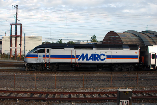
MARCUsing what I call the "Transformational Projects Action Planning" approach, which suggests that master planning approaches include an element outlining anchor projects to drive the plan forward it's worth outlining a program for Maryland's railroad passenger program.

It's especially relevant in light of a couple recent articles, GGW's "Maryland wants to slash its funding for transit, and it would hit Baltimore hard," in response to the State of Maryland's proposal in the Consolidated Transportation Program, the six-year capital program for the state's transportation program, which proposes to cut funding for transit significantly, and the piece, "On Transit, Pondering What Might Be and Lamenting What Might Have Been," in Maryland Matters about a recent forum on transit/transportation sponsored by the Greater Baltimore Co.mmittee and the Greater Washington Partnership.
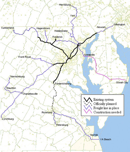
  • In 2006, I started writing pieces about how Maryland and Virginia should merge their railroad passenger programs and develop a more expansive service profile, based on a bunch of ideas first outlined by Dan Malouff/BeyondDC in the late 1990s.
-- "A regional railroad passenger transportation vision for DC, MD, VA, WV and parts of PA"

Proposed map of a Washington-Baltimore regional rail system

Railroad system Washington-Baltimore region

-- "Why don't Maryland and West Virginia think about expanding MARC into a true regional system?," 2012
-- "More on Union Station DC and the need for innovative master planning," 2011
-- "DC State Rail planning," 2015
  • Later I called the proposed service RACER, for Railroad Authority for the Chesapeake Region [insert cool graphic here].
-- "Regional transportation planning and fixed rail service," 2009
Overground, London UK
  • To provide more regularized commuter services comparable to S-BAHN service in Germany, RER in Paris, or the London Overground, I laid out a program to better integrate DC area Metrorail with regular railroad service using the London Overground model
-- "One big idea: Getting MARC and Metrorail to integrate fares, stations, and marketing systems, using London Overground as an example," 2015
  • To move this idea along, I suggested merging the MARC Penn Lines and the VRE Fredericksburg Line into one line, and worrying about the rest of the program later
-- "A new backbone for the regional transit system: merging the MARC Penn and VRE Fredericksburg Lines," 2017

It would also have the advantage of providing the opportunity for real railroad service to and from National Airport.

-- "A brief comment on ground transportation at National Airport vis a vis VRE rail service," 2016
  • Also to provide a means for implementation, I suggested the creation of a German style "transport association" linking transportation planning organizations and mobility providers including transit agencies across DC, Maryland, and Virginia.
-- "The answer is: Create a single multi-state/regional multi-modal transit planning, management, and operations authority association," 2017
(The Purple Line will connect to all three existing MARC lines)
-- Item #3 calls for integrating MARC fares into the SmarTrip/CharmCard fare system
-- Item #4 proposes all day bi-directional service on the Brunswick Line
-- Item #5 proposes a more Metro-like fare system on the Brunswick Line between Montgomery County and DC
-- Item #6 proposes that the proposed White Flint infill MARC station be built forthwith
-- Item #7 proposes an infill MARC station in Northeast DC
-- Item #14 reiterates the concept of merging the MARC Penn and VRE Fredericksburg lines to spur the creation of a regional passenger railroad system

A passenger rail vision for all of Maryland, not just getting to and from DC.  It's not like Maryland doesn't do rail planning.  In 2007, Maryland produced a wide ranging program for rail expansion, including more service, bi-directional service on the Brunswick Line, and weekend service on the Penn Line.

-- MARC Growth and Investment Plan (2007), Maryland MTA
-- MARC Growth and Investment Plan Update: 2013 to 2050 (2013), Maryland MTA
-- MARC Growth and Investment Plan: Overview and Status Update (2018), Maryland MTA

But this was just before the onset of the Great Financial Crisis and instead of expanding, the system pulled back.  Since the plan, only weekend Penn Line service has come to fruition.

Today, the 2007 document isn't even on the Maryland DOT website. Although to be fair, MDOT is updating the plan in the meantime.

But the big problem with the plan from a vision or "Transformational Projects Action Planning" approach is that Maryland's railroad planning is DC-centric, focused primarily on getting commuters to DC for work and then back home.

It's not focused on developing a broad program of railroad passenger service for the entire state, with the aim of creating a full-fledged network with frequent service--I call this network breadth and network depth--and if not 24/7 service, at least 18/7 service, so that most of the state can benefit from passenger railroad service.

That's how metropolitan rail service works in Germany, where the suburban "commuter" rail system (S-bahn for suburban railroad) is tightly integrated into the overall transit planning program for each major city, providing a backbone for the system, but also providing passenger service more generally, rather than being a true commuter service, focused primarily on providing transportation during the 9-5 workday.

New rail routes "Beyond DC."  MARC service today is based on historical passenger railroad service patterns.  By the 1970s, three Maryland-based commuter services still existed, serving Baltimore and Washington: the Penn Line from Perryville to DC; the Camden Line from Baltimore to DC; and the Brunwick Line from Martinsburg, WV to DC.  The latter two were provided by the B&O Railroad (CSX); the Penn Line by Penn Central and later Conrail.

MTA Maryland/MARC commuter railroad Map
MTA Maryland/MARC commuter railroad map

Starting in 1974, in response to threatened cuts in service, Maryland began providing subsidies to these routes, first to the B&O lines and then to Conrail.  When Congress mandated that Conrail, which inherited the Penn Line commuter service, cease providing passenger services, Maryland paid Amtrak to run the line.

In 1984, the state's railroad operations were organized into and branded as MARC and over time operational arrangements for the three lines have changed.  In Maryland and Virginia, Amtrak also provides some complementary service.

(In Virginia, this is provided under the rubric of the Amtrak Virginia program spearheaded by the Virginia Department of Rail and Public Transportation.  In fact Gov. Northam of Virginia has declared October "Passenger Rail Month" to bring more attention to the Amtrak Virginia program.)

The first BeyondDC graphic, "Washington-Baltimore Regional Rail" shows the basic concept of a statewide rail passenger program, although some parts of the state aren't covered.

1.  To set the stage, merge the MARC Penn Line and the Virginia Railway Express Fredericksburg Line, to provide through running and Maryland connections to key Northern Virginia destinations, especially Crystal City, which will be home to Amazon's HQ2, and National Airport, along with a direct connection to L'Enfant Plaza in DC.

This is dependent on an expansion of Long Bridge, the rail bridge connecting DC and Virginia, to four tracks (Plan for Long Bridge expansion moves forward," Washington Post) and is in keeping with Virginia's goals concerning rail expansion.

VRE, Virginia Railway Express commuter railroad map

2.  Beyond the current lines, it shows the following changes to the service footprint in Maryland:
  • An extension of the existing Penn Line service from its endpoint in Perryville to Wilmington Delaware where it would connect to the SEPTA service out of Philadelphia
  • Service between Annapolis, the State Capital and Washington
  • Service between Baltimore and Annapolis
  • Service between Baltimore and Westminster in Carroll County
  • Service between Baltimore and Harrisburg, Pennsylvania
  • Service between Martinsburg, West Virginia and Hagerstown, Maryland.
3.  The second BeyondDC graphic shows the potential for three more extensions:
Easton, Maryland train station, Baltimore, Chesapeake and Atlantic Railway

4.  I would add two additional lines not shown on either graphic:
  • Service between DC and Southern Maryland, especially Charles County, but including stations in DC between Union Station and the DC-Maryland state line
  • Although an MTA study, the Southern Maryland Commuter Rail Service Feasibility Study proposes service to Charles and St. Mary's County by branching off from the Penn Line, whereas my idea was to do this via DC south from Union Station
Maryland MTA proposal for rail passenger service to Charles and St. Mary's Counties
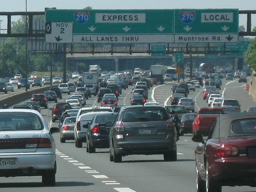
  • Consideration of the addition of a line to the I-270 corridor, from Frederick to Bethesda and then to DC and Northern Virginia (it would be electrified and a goodly portion would run in a tunnel created through cut and cover construction under I-270).
Interstate_270My second MARC line in Montgomery County might not be necessary, but it would be better placed to capture traffic and passengers more directly in the I-270 corridor, which I argue should be consider edfrom a corridor management approach there, rather than reflexively pushing HOT lanes.

It should be studied and is mentioned as an item in "Revisiting the Purple Line (series) and a more complete program of complementary improvements to the transit network," 2019.


5.  Adding infill stations across the existing system, such as:
  • the three stations for Baltimore proposed in the original Growth and Investment Plan but later dropped: Bayview and Madison Square in East Baltimore; and Upton in West Baltimore
  • in DC in the New York Avenue corridor on both the Camden and Penn Lines
  • in DC at Fort Totten as a redundancy platform vis-a-vis Union Station (although the Silver Spring MARC station also serves this function, etc.
6.  Finally, considering opportunities for the Eastern Shore and the Camden Line more thoroughly.

My previous writings never anticipated a significant change in the profile of the Camden line service because the stations aren't particularly well-placed to generate significant ridership increases, but an objective study would evaluate the line for changes also.

Conclusion/Positioning.  The reality is that the current governor, Republican Larry Hogan, does not support transit.  But he has continued to support efforts by the State of Maryland in association with other Mid-Atlantic and Northeast states for joint initiatives aimed at staunching climate change through the Transportation and Climate Initiative (TCI) of the Northeast and Mid-Atlantic states.

Perhaps by positioning this approach in that vein, as well as serving many more parts of Maryland outside of the Baltimore and Washington metropolitan areas, and in terms of creating a legacy that would be unmatched by any other U.S. state, at least at this time (no state really has a statewide railroad transportation program quite like this) maybe Governor Hogan can be convinced to support the expansion of MARC into a true statewide passenger rail service that goes far beyond its existing footprint as a DC-focused commuter rail service.

Other states should do two stage rail planning too.  All states with some form of rail passenger service have created state rail plans in order to comply with the federal Passenger Rail Investment and Improvement Act of 2008. Some plans are better than others. I can't say I've read many of the plans.

But none of the plans lay out a bigger vision for a complete state-based passenger rail network, unlike the existence of a complete road and freeway network.  It's unlikely any of the plans I haven't read are organized at the two scales I propose here:

(1) a big vision, Transformational Projects Action Plan and

(2) what is called a "Constrained Plan" based on the availability of capital both current and reasonably projected.  (Also see "New Transportation Planning Paradigm: Constraints-Based
Planning in the Era of Limited Transportation Funds
.")

Note that the MARC plan for 2050 isn't particularly visionary. It calls for additional service, but not a lot more service, and more dedicated tracks where needed in the current footprint, but it doesn't call for any passenger railroad service outside of the basic footprint provided today. It definitely doesn't call for full bi-directional service on the Brunswick Line between Frederick and DC.

And really, this is merely trying to re-create what once existed.

-- Kilduff's archive of Maryland railroad stations

(if you click on the map it goes to the much larger image at the Library of Congress)  This railroad map dates to 1876.
New railroad map of the state of Maryland, Delaware, and the District of Columbia. Compiled and drawn by Frank Arnold Gray, 1876

Labels: , , , , ,