Rebuilding Place in the Urban Space

"A community’s physical form, rather than its land uses, is its most intrinsic and enduring characteristic." [Katz, EPA] This blog focuses on place and placemaking and all that makes it work--historic preservation, urban design, transportation, asset-based community development, arts & cultural development, commercial district revitalization, tourism & destination development, and quality of life advocacy--along with doses of civic engagement and good governance watchdogging.

Saturday, February 08, 2025

Just a reminder to do and effectuate access planning before major transportation infrastructure opens: Peru's airport

 According to Bloomberg, "Nice Airport, If You Can Get to It: No Subway, No Highway, No Bridge," Lima Peru is getting a new airport without roadways to it--they are planning to cross a river with temporary bridges and no transit.  From the article:

A highway meant to whisk travelers to the $2 billion terminal has yet to be built, even though flights are supposed to begin operating in just seven weeks. A bridge to get across a river that runs along the grounds was never constructed. There’s a subway stop labeled “Airport” planned for Lima’s new metro system, but that station is set to be built (three years from now) much closer to the old airport that’s being decommissioned.

“Having a subway station named ‘Airport’ where there won’t be an airport anymore — it’s just the most graphic example of our lack of planning as a nation,” said Carlos Gutierrez, the head of Peru’s airline industry trade association.

... The bridges will get private cars from congested side roads into the terminal, but there’s no bus service currently scheduled, and there’s no room to allow pedestrians to walk across. That’s a problem for the airport’s 17,000 workers, most of whom now arrive at the existing terminal via public transportation. And officials are worried about the safety of travelers forced to navigate the traffic-choked streets in the crime-filled neighborhood that surrounds the airport.

I do think airport mobility planning in the US can be weak.  It was abetted for years by a rule by the Federal Aviation Administration that airports couldn't pay into existing transit systems that also serve non-airport riders.  Fortunately, the Biden Administration dropped that rule.  But it still affects airports like LaGuardia, Newark, JFK, and Philadelphia.

... US airports with decent transit like Cleveland or National in DC are connected through the largesse of local authorities.  

-- "Manhattan Institute misses the point about the value of light rail transit connections to airports | Utility and the network effect: the transit network as a platform," (2020)

-- "To and from origin stations can be difficult: More on the Silver Line and intra-neighborhood transit (tertiary network)," (2022) -- links to many past entries

Although lack of access planning for regular transit stations is an issue too.  In Baltimore it was an issue with the Lutherville light rail station. In DC, with the NoMA station among others ("Revisiting creating Public Improvement Districts in transit station catchment areas," 2020).

Labels: , , ,

Saturday, January 15, 2022

Op-Ed in Washington Post about preserving affordable housing in the Purple Line corridor (Department of Duh)

There is an op ed, "Maryland must do more to preserve housing around the Purple Line," in the Washington Post by David Bowers of the Enterprise Community Partners--one of the nation's leading affordable housing constructors and advocates--about the need to preserve affordable housing in the swath of Montgomery and Prince George's Counties that will be served by the Purple Line light rail because new transit will lead to housing price appreciation.  

From the article:

When construction on the Purple Line began in 2017, the Purple Line Corridor Coalition, a multi-sector group, estimated that 17,000 affordable homes in the line’s vicinity were at risk of being lost to market forces. Rent increases will lead to displacement; 47 percent of all renters in the area around the Purple Line are already rent-burdened, meaning they pay more than 30 percent of their monthly income in rent. They can’t afford to pay more.

The concerns about housing appreciation due to better transit access from new projects aren't new.  

It's been an issue in the Langley Park community for more than 10 years ("In Langley Park, Purple Line brings promise, and fears, of change," 2011; "Along the Purple Line, worries that new transit will bring higher rents," 2021, Washington Post) and was raised in the Columbia Pike community of Arlington when they were considering streetcar service there ("Columbia Pike housing, transit questioned," 2012, Washington Post).

And those concerns are logical based on the experience in the region with Metrorail and how it has led to significant price appreciation, especially in core neighborhoods in Washington, DC and Arlington County, Virginia, even if it took a couple decades and longer to become visible.

One example is how the addition of the NoMA Red Line infill station in 2004 led to a significant increased in demand for housing north of H Street NE.  Since then housing prices have increased by 6x to 10x.

Express newspaper, 2012.

For what it's worth, I first suggested that Montgomery and Prince George's Counties go in on a community development corporation to address this in a brief blog entry in 2009.  

Relatedly in 2012, "Time + improvements in transit infrastructure = increased housing values."

Then in response to two conferences organized by the Purple Line Coalition in 2014, I wrote two pieces about this ("Purple line planning in suburban Maryland as an opportunity to integrate place and people focused initiatives into delivery of new transit systems" and "Quick follow up to the Purple Line piece about creating a Transportation Renewal District and selling bonds to fund equitable development").  

At the time, I talked about this with a member of the Montgomery County Planning Board, and he said it wasn't an issue of concern with the chair, because the chair couldn't see such a response being adopted, so why bother?

In 2017, I updated the post a wee bit and included it in the Purple Line series of articles about how to respond to and leverage the Purple Line as an addition to the Washington metropolitan transit network.

-- "PL #6: Creating a transportation development authority in Montgomery and Prince George's County to effectuate placemaking, retail development, and housing programs in association with the Purple Line"

Now that the Purple Line is going to be delivered 4+ years late, Maryland gets a little more time, but not much.  The places that are likely to be good locations for market rate housing are already being developed ("Suburban Maryland Purple Line light rail as an already successful economic development driver," 2020).

Amenities at the Chevy Chase Lake development will include a swimming pool, outdoor grills, co-working spaces, a wine room, a game room, a library, a bar and a fitness center. (Imerza)

For example, in Chevy Chase, new development is underway to leverage its location to the coming Purple Line ("New apartments leasing in Chevy Chase Lake in Montgomery County," Washington Post).  From the article:

Three residential developments are slated to be part of the Chevy Chase Lake development in Montgomery County, Md., designed to be a walkable mixed-use community with a town center and access to the Capital Crescent Trail. The development is adjacent to Connecticut Avenue and the planned Purple Line transit system, which will provide an east-west connection between Montgomery and Prince George’s counties.

My idea was that among its activities, the Bi-County CDC would help to fund, buy, operate and hold affordable housing in the corridor, including buying existing properties and adding more housing to them. 

Note also I was intrigued how Seattle was considering this issue wrt the Martin Luther King Corridor and the forthcoming addition of light rail there ("MLK Way: More than a highway or a piece of the next grand plan, it's home," Seattle Times).  I blogged about it in 2005.

And I was impressed by a proactive community development housing production initiative in Greater Phoenix in association with the light rail program there ("Light rail housing fund spurs 15 projects in metro Phoenix" and "Why you don't see more vacant lots along light-rail route," Arizona Republic).

How much time is necessary to respond to an obvious situation?

======

I find the affordable housing "argument" frustrating, because the problem is obvious--not enough housing--and the solution is obvious--build more.

But it costs money and requires government action is counter to the neo liberal argument that the market will solve every problem and government is ineffectual.

After reading an article about a project in Long Beach, California, I looked up Mercy Housing, a multi-state CDC focused on AH production, and this is on their website:

Nationwide, there are only 31 affordable units for every 100 extremely low income renters. In no state can a full-time minimum wage worker afford a one-bedroom or a two-bedroom rental unit at Fair Market Rent. 2.5 million children are homeless each year in the U.S. These sobering numbers are only a few of the many illustrating our country’s dire need for affordable housing.

These statistics couldn't be more clear.  There is great demand for affordable housing.  But if you want more affordable housing, you have to build it and it won't be produced by the for profit real estate development community, at least not without subsidy.

FWIW, the chapter on housing in Jumping the Abyss: Marriner S. Eccles and the New Deal, 1933–1940 is must reading.  The way that the housing market was restructured in the 1930s has set the stage of the US housing market ever since.  

Even then it was understood that housing for the lowest income segments would have to be subsidized.  But the "bias" or preference of policy makers was in favor of private housing production and not providing subsidies.  

Even though various legislation authorized affordable housing production, it was a very small part of New Deal housing measures.  And after a time, active government involvement in affordable housing was forbidden, and severe restrictions on what could be produced and for how much were also imposed, making production of high quality affordable housing increasingly difficult.

Today's piece by Philadelphia Inquirer urban design columnist Inga Saffron, "The Philadelphia Inquirer: The city desperately needs more public housing. There’s a perfect site in West Philadelphia," is equally illuminating.

She points out that since the Clinton Administration, public housing policy has focused on reducing the number of low income housing units, adding market rate housing to AH developments, lessening a focus on providing housing for the lowest income segments, and limiting new production.  From the article:

The real crisis in Philadelphia is poverty. Even as the city’s economy has rebounded over the last two decades, launching a building boom that has shined up blighted neighborhoods, its poverty rate has grown steadily worse. Almost a quarter of city residents struggle to pay for food and housing — 65,000 more than in 2000. No matter how many houses Philadelphia’s private developers build, those low-income residents will never be able to afford the rent. ...

Why doesn’t PHA just build more apartments? The short answer is that the federal government has drastically reduced funding to the nation’s housing authorities over the last three decades and imposed strict limits on new construction through the Faircloth Amendment. Things got so bad here that PHA closed its waiting list to new applications (except for seniors and the disabled) in 2013. The situation isn’t unique to Philadelphia: Today, there are 200,000 fewer public housing units available nationally than during the Clinton era.

So yes, as poverty and housing prices have increased, not just in Philadelphia, but nationally we have:

  1. reduced the number of low income housing units; 
  2. restricted construction of new low income housing units; and 
  3. reduced the amount of money available to public housing authorities.

And we wonder why there is an AH supply problem?, while conveniently blaming "greedy developers."

Labels: , , , , , , ,

Tuesday, January 11, 2022

Revisiting: Access to Theodore Roosevelt Island, a national park in Washington, DC

(Preparing for another "revisiting" post, this occurred to me as well.)

Theodore Roosevelt Island is one of the many national parks in DC ("Defining National Park Service installations in DC as locally or nationally serving," 2019).  It is unusual in that it is an island park, in the middle of the Potomac River.   

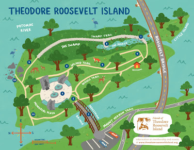
-- NPS brochure

Working on a civic association initiative in Foggy Bottom in 2007, some participants pointed out the park was inaccessible from DC. There is a bridge from Virginia, and the access point includes a parking lot.

Graphic design by Molly Fehr
This map shows access from the Virginia side of the Potomac River

Park access is a big issue generally, in DC and many other places ("A gap in planning across agencies: Prioritizing park access for pedestrians, bicyclists and transit users compared to motor vehicle access," 2015).  Too many places fail to systematically plan and implement high quality park access for multiple modes.

I don't remember the group's specific recommendations, but in 2018 I suggested at the least, a water taxi service in the summer, using water taxi services for Governors Island in New York City, between New London and Groton Connecticut as examples, and boat access to the Anacostia River as sponsored by the Anacostia Watershed Society ("Why not a summer "water taxi" service to Roosevelt Island in the Potomac River").  

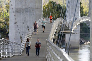
Runners and pedestrians along a bridge suspended under the Lee Bridge over the James River from Belle Isle, in Richmond, Va., where you'll find locals exploring the 54-acre island and resting on its rocky shores. Belle Isle was first explored in 1607 by Capt. John Smith, who helped establish England's first North American settlement in Virginia.

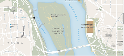
Looking at the National Park Service map of the National Mall for a future posting, it occurs to me that you could build an add on pedestrian bridge to the Theodore Roosevelt Bridge of I-66.

Just as there is a bicycle bridge appended to the 14th Street Bridge between DC and Virginia, or the Belle Island Pedestrian Bridge, constructed under the freeway bridge for US 1/US 301, providing access to Belle Island, which is part of the James River Park System in Richmond.  The Belle Island bridge opened in 1991.

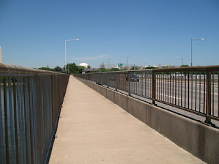
14th Street Bridge bicycle path.  Flickr photo by Mr. T in DC.

It wouldn't be the absolute best location, from a usage standpoint, it'd be better to do it from the Georgetown waterfront.  

Although the plus would be the access point would be from Rock Creek Park and the bike trail, and is close to the Kennedy Center.

OTOH, this option would have minimal negative effect on the Potomac River viewshed, because this particular location is already marred by a bridge.

Such a project would be eligible for federal transportation funding.

Ideally, it could be part of a broader initiative to improve park access throughout DC.

Labels: , , , , ,

Friday, February 14, 2020

Local Washington Post op-ed: Gentrification pushes people from homes and away from transit

From the article that I guess will be published this Sunday:
A recent study by the University of Minnesota found that in the District, low-income residents are being pushed out of gentrifying neighborhoods at the highest rate in the country. The neighborhoods that have experienced the largest outflow of low-income residents, according to the study — places such as Logan Circle, Petworth and Columbia Heights — have an average walk score of 82.5 and an average transit score of 74.5. ...

The Purple Line, scheduled to open its first five-mile stretch in late 2022, is expected to provide daily service to nearly 75,000 people, some of whom now live in transit deserts. But three years is a long time to wait. Transit improvements can make low-income residents worse off by driving up house prices and making them vulnerable to displacement, says David Bowers, vice president and Mid-Atlantic market leader for housing finance organization Enterprise Community Partners. So, maintaining the supply of affordable housing concurrently is key. The Purple Line Corridor Coalition has released a Housing Action Plan that proposes to preserve 17,000 affordable housing units along the planned route.
Umm, duh. But a Housing Action Plan without implementation mechanisms won't do much.

It happens that in 2009, and then in 2014 after a Purple Line conference at the University of Maryland I suggested that a bi-county community development corporation be created to buy, hold, fund, and develop properties with an aim at maintaining affordability based on the likelihood of price appreciation based on the real examples of DC and Arlington County in the face of changes unleashed by Metrorail even though it took a almost three decades after the first leg of the Metrorail system opened in 1976 to begin seeing displacement occur in a significant way.

This piece from my 2017 series of articles on leveraging the investment in the Purple Line with complementary improvements to the transit network primarily updated my 2014 writings:

-- "Part 6 |  Creating a transportation development authority in Montgomery and Prince George's County to effectuate placemaking, retail development, and housing programs in association with the Purple Line"

1.  Create a companion "Revitalization District" that wraps around the newly created transportation infrastructure, and create a "Tax Increment Financing" program to raise a very large fund, which could increase significantly the velocity of revitalization, and to purposefully fund the kinds of equitable development activities espoused by the Purple Line Corridor Coalition.

2. Rather than creating a variety of micro-TIF districts for various projects, this proposal is for a large single fund, but with a detailed program facilitating projects at various scales and locations, but using the large tax district as a way to realize projects across all parts of the catchment area, including areas where current demographics and economic conditions wouldn't normally support financing for such projects.

3. Originally I did not foresee using TRD monies to fund the construction of transit infrastructure per se, but to fund new property development by both for profit and nonprofit entities, property acquisition to maintain long term affordability, civic infrastructure, and community improvement programs of various types.

Now I would include transit network improvements as eligible for funding, and would even consider using a portion of the revenue stream to fund the actual construction of the Purple Line specifically.

4. The lessons from DC and Portland's use of an Urban Renewal District to fund most of the local match for the Yellow Line light rail is that it takes 30-40 years to see fully the investment, so the TRD needs to be set up to last a long time--typically an urban renewal district's funding is for a 20 year period and then ceases, although Portland has a process for extending the period.

5. Recognizing that new development results in new costs for existing systems like emergency services and schools, "all" of the forecasted increase in property taxes should not go to the TRD, some of the stream should be reserved and fund such services.

6.  Action plans would need to be created, along with the right accountability mechanisms and marketing systems, along with some flexibility to respond to changes in market conditions, circumstances, and opportunities as they development. 

Transit network improvements that are equity focused.  The op-ed makes a good suggesting about improvements to the transit network's breadth and depth as a result of displacement and lower income households being forced to move to outlying areas where transit connections are sub-standard.
By contrast, the neighborhoods receiving the largest inflow of low-income residents — suburbs including New Carrollton, Aspen Hill and Annandale — have an average walk score of 42.5 and an average transit score of 28.8.

This means the District’s most vulnerable residents, who had not historically relied on a car because they lived in dense urban zones, are being pushed into areas where having a car is necessary. Many can’t afford one.

One shorter-term option is to extend bus lines and increase frequency of buses serving the areas experiencing population inflows. Efforts such as the Bus Transformation Project are vying to improve the region’s bus system. Another option is to continue expanding micromobility options, including services such as Jump bikes and Skip scooters, which aren’t tied to docking stations that may be absent in transit deserts.
I have made a similar kind of point for a long time, that the transit network's breadth and depth should be planned separately from the budget for transit.  Although my focus wasn't on equity, just creating a great transit system that works for everyone.

It happens that an op-ed piece earlier this week in the Guardian about alleged plans to improve bus transit offerings in the UK sort of mentions this, calling for the UK to look at the way Switzerland manages its transit ("If Boris Johnson really wants to improve the UK's buses, he should look to Switzerland").

But it's not rocket science. And in the UK the problems are even easier to figure out. Except for London, they completely privatized the bus system and eliminated a network planning organization or requirement.  Private corporations provide service where it is most profitable (unless the local government provides subsidies to operate a route.)

But the Switzerland model is really German.  In any case, the "Switzerland model" is the kind of network management proposal I've been recommending for years:

-- "The answer is: Create a single multi-state/regional multi-modal transit planning, management, and operations authority association," 2017
-- "Will buses ever be cool? Boston versus the Raleigh-Durham's GoTransit Model," 2017
-- "Making bus service sexy and more equitable," 2012

And it's based on the German VV, Verkehrsverbund ("transport association") model.  (Seeing it in operation in Hamburg was really eye-opening.  Even though I was also in Essen, because the Ruhr is so spread out you can't see the same level of coordination as there is in Hamburg.)

-- VDV, the trade association for German transport associations
-- "Verkehrsverbund: The evolution and spread of fully integrated regional public transport in Germany, Austria, and Switzerland," International Journal of Sustainable Transportation (2018)
-- Transport Alliances - – Promoting Cooperation and. Integration to offer a more attractive and efficient Public Transport, VDV.  NOTE: if you click on this link it will just download the file

Transit improvements to the network in association with the Purple Line.  WRT the Purple Line, my complementary transit network improvement recommendations ("Setting the stage for the Purple Line light rail line to be an overwhelming success: Part 2 |   the program (macro changes)") are more focused on changes around the Purple Line.

They aren't specifically equity focused, but result in equity improvements.

Items 10, 11, 12, 13, 15 and 19 address improvements to bus service. One hindrance is that the State of Maryland generally forbids investment in better bus service that crosses the DC-Maryland land. Many bus lines are broken into two at the DC line.

10. Bus service in certain corridors between DC and Maryland should be extended and/or frequency increased to better link these areas to the new light rail service.

11. Montgomery County bus system improvements with the launch of the Purple Line and bi-directional service on the MARC Brunswick Line should include launch of planned Bus Rapid Transit services.

12. Rearticulate, rebrand, and reposition-extend the Prince George's County TheBus bus transit service. Change the name of the service and the graphic design of the bus livery.

13. Consider a redesign and rebranding of the the metropolitan area's bus systems into an integrated framework, comparable to that of GoTransit in the Raleigh-Durham area.

15. Set the opening of the Purple Line as the deadline for the implementation of a full-fledged integrated Night Owl bus network for the DC metropolitan area.

19. WMATA should upgrade its Metrorail station bus shelters.

Based on previous writings, I also called for a merger of MARC and VRE, starting with the MARC Penn and VRE Fredericksburg lines. Items 3, 4, 5, 6, 7, and 14 address train integration and improvements.

3. Integrate MARC fares into the SmarTrip/ CharmCard fare media system.

4. Introduce bi-directional passenger rail service between DC and Frederick on the MARC Brunswick Line.

5. Consider charging DC-Montgomery County trips on a bi-directional Brunswick Line using the Metrorail/Purple Line tolling/fare schedule. That would treat mileage from railroad trips in the context of a complete (linked) trip on railroad+subway+light rail as a single fare.

6. The White Flint Sector Plan calls for an infill MARC station. Plans to build that station should be accelerated as part of this proposal.

7. Build an infill train station in DC on the Penn Line, serving the New York Avenue corridor.

14. Set the opening of the Purple Line as the deadline for the integration of the MARC Penn Line and VRE Fredericksburg Line into one combined railroad passenger service.

Conclusion. These lists are Purple Line specific, and all of the changes aren't necessarily equity focused, although there would be plenty of equity benefits. For example, separately in a similar piece about Northern Virginia ("Using the Silver Line as the priming event, what would a transit network improvement program look like for NoVA?") item 27 discusses long distance commuter bus services. But there are other recommendations concerning bus transit as well.

And again, not including improvements that take longer than 5 years into the initial series limits huge equity initiatives like extending the Purple Line to Virginia from Bethesda and from New Carrollton to Alexandria.

There are many other improvements that can be made to network breadth and depth were there such a planning and operations system focused on bringing it about.

For example, this piece outlines a truly statewide passenger rail program for Maryland ("A "Transformational Projects Action Plan" for a statewide passenger railroad program in Maryland").

The same goes for housing affordability vis a vis transit. But without plans, planning, implementation mechanisms, and financing it will never happen.

Labels: , , , , , ,

Wednesday, December 05, 2018

President George H.W. Bush

Yes, it bothers me that when past presidents die, most of the media coverage is hagiography and glosses over the bad stuff.  Such is the case with President George H.W. Bush, who among other things used highly racist campaign message and was involved, somehow, with the Iran-Contra affair.

There are some pieces out there saying that yes, President Bush was a gracious person, but that's not enough.

-- "The Media Got George HW Bush Wrong in Life and Death," New Yorker
-- "The Ignored Legacy of George H.W. Bush: War Crimes, Racism, and Obstruction of Justice," The Intercept

WRT transportation, mobility and accessibility, his administration wasn't against transit, the way the current Republican administration is, and he signed the Americans for Disabilities Act, which among other elements, requires that public spaces including streets, sidewalks, and transit, be accessible to the disabled.

-- Introduction to the ADA, ADA.Gov website
-- "Remarks of President George Bush at the Signing of the Americans with Disabilities Act," Equal Employment Opportunity Commission
-- Accessibility, US Department of Transportation

It turns out too that accessibility is helpful to everybody.  People with packages, people crossing streets, bicyclists, people pushing strollers, etc.

While most communities have made progress with this in terms of the sidewalk network, not all transit agencies have, including the New York City Subway system.

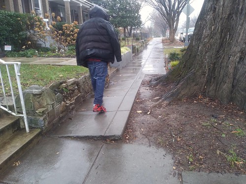
Sidewalk uplift, Kansas Avenue NWSidewalk uplift on Kansas Avenue NW.

Although communities may still miss important aspects.

For example, DC has an extensive program making sidewalks at intersections accessible (a lot of this is upgrading already existing ramps), but for the most part, doesn't address mid-block sidewalk problems, even when doing projects in close proximity.

I think that simultaneously, cities should prioritize mid-block repairs as well as intersection upgrades.

Labels: , , , ,

Saturday, January 02, 2016

Hong Kong needs to create a formal and planned pedestrian mobility network

700 Nathan Road, Kowloon, Hong Kong
The footbridge from the Mong Kok transit station does not connect directly to the building at 700 Nathan Road, Kowloon, Hong Kong.

There is an op-ed ("Ministry of silly walks: Hong Kong officials are shirking their responsibility to make crowded Mong Kok a better place for pedestrians") in the South China Morning Post about failures by the government in developing better links in the pedestrian network between private and public spaces.  It's by Paul Zimmerman, a city councilor and director of Designing Hong Kong, a nonprofit advocacy group focused on land use, urban design, and transportation matters,

The Mong Kok footbridge crosses Fa Yuen Street but needs to link up with Argyle Street. Photo: Jonathan Wong, SCMP.

The specific example concerned barriers to improved pedestrian mobility as a result of urban design flaws within and between a particular building and a train station and the street network, where an above-ground walkway doesn't continue into a building, forcing pedestrians getting to their final destination to go down to the street to enter the building, or out of the building to get to the walkway to the transit  station.

The building is for sale by its owner, the Government of Hong Kong, and the author suggests that the sales agreement for the building should have included requirements for the improvements. From the article:
In our campaign to improve walkability, our latest encounter ... is over the sale of the Trade and Industry Department Tower, formerly known as Argyle Centre Tower II, on Nathan Road in Mong Kok. It is a 1980s building owned by the government. The tender for its sale closes on January 8. We have asked for it to include terms which oblige the buyer to internalise the links to Mong Kok MTR station and the Mong Kok Road footbridge. These stairs and escalators currently obstruct pavements and roads surrounding the building.

Removing these structures from the adjacent pavements and roads would improve pedestrian and vehicular circulation at street level. Moreover, linking the footbridge with a new Argyle Street footbridge via the Argyle Centre Towers is a critical piece of the puzzle the government has been struggling with: the creation of a comprehensive elevated pedestrian network desperately needed to alleviate the overcrowding of Mong Kok’s streets.

The sale of the building is a one-off opportunity to improve walkability. If we fail to spell out these requirements in the tender, it will be hard to convince the buyer to give up gross floor area later to invest in the works.
Reading the article, even though the city's area and transportation plans include elements for improving pedestrian mobility including above-ground footbridges and below ground tunnels (they call them subways) it occurs to me that unlike cities such as Chicago (Pedway), Minneapolis (Skyway), Montreal (Underground/RESO-La Ville Souterraine), and Toronto (PATH), Hong Kong hasn't defined an enhanced, comprehensive, and integrated pedestrian mobility network, even though it has plenty of underground and above-ground pedestrian walkways and connections between buildings and transit stations, utilizing both public and private space.

(Note that there are many more examples of such mobility networks, mostly underground, most of which I am completely unfamiliar with, but are helpfully listed on the Wikipedia Underground City page.)

Hong Kong also has a semi-unique element of its own, public escalators in a couple of places, which facilitate movement up and down steep spaces.  (Medellín also has a similar system of escalators in steep places, designed to facilitate movement up and down.)

Hong Kong's system of 20 escalators serves 50,000 commuters daily, moving up a vertical incline of about one-half mile.  Drawing by Simon Fieldhouse.

The foundation of the issue raised by the op-ed, better integration of pedestrian linkages between the Mong Tok MTR station and the Argyle Towers building and using the sale of the building as a way to facilitate and force the changes, isn't so much "a one-off opportunity" but an indicator of the need for a more comprehensive and integrated approach.

It's also a common problem with the utilization/sale of public assets, when governments sell properties they are loathe to put in a lot of conditions, believing it will reduce the net proceeds or scare off potential buyers, rather than consider the long term benefits of achieving a broader set of objectives.  Myself, I'd be happy with a lot less money in return if the project yielded significant public good benefits in terms of urban design, placemaking, community improvement, and civic architecture.

Hong Kong needs to organize and define its current collection of disparate pedestrian infrastructure elements into a formalized system, and brand, market, and plan it, including better ways for identifying gaps and addressing potential improvements within the network, just as Toronto has done in its most recent PATH Master Plan (image at right).

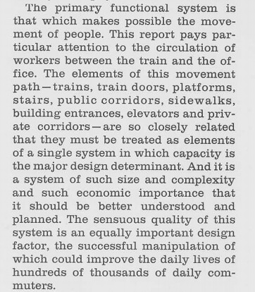
Another very old resource is the Urban Design Plan for Midtown Manhattan, Urban Design Manhattan, created by the Regional Plan Association as an element of the multi-part "Second Regional Plan," in the late 1960s.

This particular section proposed the creation of a formalized off-street pedestrian network, both underground and above-ground (not so much skyways as mezzanines and second floors of office buildings) using public and private spaces.

It defines the "Access Tree" linking horizontal and vertical pedestrian movement between underground train stations, streets and sidewalks, and (primarily office) buildings.  It defines the train stations and platforms as "the roots," of the system, elevators (and ramps, sidewalks, and escalators) as the "trunks," and sidewalks and office building (lobbies and) corridors as "branches."  The tree connects to buildings through "mixing chambers" at the street level, around which are clustered the tallest buildings, which are located close to high capacity transit.  (See excerpts below.)

Very very dense cities like Hong Kong, New York, and London need such formalized approaches and plans.  As do even smaller cities with underground transit systems.

Functional mobility of pedestrians in Midtown Manhattan, from Urban Design Manhattan
pedestrian mobility, Urban Design Manhattan, Second Regional Plan, Regional Plan Assn.

Access Tree, from Urban Design Manhattan
Access Tree, Section from Urban Design Plan, Second Regional Plan, Regional Plan Assn.

Labels: , , , , ,

Saturday, December 12, 2015

A gap in planning across agencies: Prioritizing park access for pedestrians, bicyclists and transit users compared to motor vehicle access

=====
This entry on access to parks as a planning issue is in response to the comment thread on the previous entry ("Lost opportunity to build cycletrack on Military Road"
=====

DC was created by the federal government to be the national capital and for most of the city's history, until the early 1970s, the city was run by the federal government.  Certain functions, especially parks, were managed by federal agencies.  The water system was run by the Army Corps of Engineers, and parks by the National Park Service, etc.

One of the results is that even after devolution and the creation of a locally elected government, most of the large park spaces in the city remain owned and operated by the National Park Service, not the local DC Department of Parks and Recreation.

DPR mostly focuses on neighborhood-serving facilities, usually anchored by a recreation center, and focused on team sports. They are active recreation facilities, not what we would think of as "regional parks," with both active and passive functions.

Even so, many interstitial spaces, such as the park spaces in traffic circles, remain under the control of NPS.

And small parks planning at the neighborhood-mixed use district level is typically neglected ("The layering effect," "NoMA revisited: business planning to build community" and "Parks: maintenance, budgeting and contingency planning") by the Office of Planning--remember that DPR is out of the picture as an effective planning agency, although the DC Department of Transportation seems to take on such projects sometimes, but not as part of a comprehensive parks and recreation plan for an entire neighborhood.

Examples of exemplary DDOT efforts include the spray park/Columbia Heights Plaza and the reconstruction of Thomas Circle.  The Starburst Plaza too, but it is poorly situated in terms of "H Street" and mostly functions as a super-big bus waiting area.
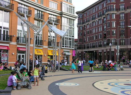
An Evening at Columbia Heights Civic Plaza in Washington, DC
An Evening at Columbia Heights Civic Plaza in Washington, DC. Flickr photo by otavio_dc.
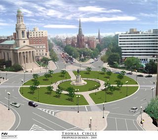
Thomas Circle Reconstruction, Washington, DC
Thomas Circle was reconstructed--it had been carved up in the 1950s to provide more lanes for motor vehicle traffic--around 2005.

Generally, "Local" parks master plans usually fail to address matters concerning county, state, and federal parks within their jurisdictions.  In terms of my thinking about parks planning and potential conflict between agencies and jurisdictions, the situation in DC is one of the primary reasons I argue that "local parks master plans" need to provide guidance and contingency planning for all the major parks and open spaces within its jurisdiction, regardless of who owns and operates a particular park, because otherwise, local resident-citizen needs and input can be significantly underrepresented.

If the local government won't represent citizen interests, too often, neither will anyone else.

These past blog entries discuss the issue of parks planning in the context of parks controlled by multiple jurisdictions:

-- "How surveys based on gross data can be very misleading: DC and parks" (this piece discusses the issue in terms of a framework and is a response to how surveys using gross data over-rate DC's park situation)
-- "Federal shutdown as another example of why local jurisdictions should have more robust contingency and master planning processes"
-- "Parks issues"
-- "National Parks Week"
-- "Local parks planning, the USDA's National Arboretum, and the Friends of the National Arboretum"

Note that the reason this occurs is because plans are usually more kind of "asset management" programs for particular agencies, rather than broader topic/theme-based plans covering a subject area comprehensively and creatively.  Plus, agencies don't like putting in plans recommendations for agencies "above" them, like state or federal agencies.

(I was proud of a recommendation that stayed in the plan I did in Baltimore County, calling for a joint planning effort by the county, City of Baltimore, and State Parks agency to jointly plan and manage biking issues across three separately controlled but contiguous parks.)

Given that state budget cuts often affect parks, local governments should have contingency plans in place so that they are prepared for those times when circumstances change, so that they can protect local concerns with regard to "state" parks operating within their jurisdictions, especially when they are threatened by closure.

DC parks planning capacity is stunted.  As a result of federal control, DC is underdeveloped in terms of its own capacity for parks planning. There have been two efforts over the past 12 years to create a parks master plan.  One at the tail end of the Williams Administration was never effectuated, although a plan was produced.

Note that another parks planning process started during the Gray Administration--they even chose the parks planning consulting firm I recommended-- is still underway but I am not sure where it's at as well as whether or not they acknowledged my criticism about the need to focus more broadly on this issue and others.  Instead, the scope of work--in my opinion anyway--seemed overly focused on "recreation" and related facilities.

The failure to construct a cycletrack on Military Road as a bike-transportation planning failure.  The previous entry ("Lost opportunity to build cycletrack on Military Road") focuses on the impact on transportational cycling from the failure to construct a cycletrack on Military Road NW in association with the just about completed major reconstruction and resurfacing project.

One commenter made the point that a cycletrack for this stretch of road is listed as a priority in the city transportation plan, which was approved by City Council in 2014.  Oops. I'm sure the response will be that the design and engineering and bids for reconstructing the road happened long before the new plan was created and approved.

Even so, it is a major failure on the part of DDOT and NPS to not recognize the opportunity to address a major gap in the bicycle mobility network.  That gap should have been evident whether or not it was identified in the previous plan.

The failure to construct a cycletrack on Military Road as a park access planning failure.  Commenter Tom Quinn pointed out the issue is bigger than better east-west access, a cycletrack on Military Road would also make the park more accessible more generally, and is representative of a broader, structural failure to ensure convenient access to the city's parks for pedestrians, bicyclists, and by extension transit users.

He writes:
What Richard left out of the piece is that the Upper reaches of Rock Creek Park are mostly accessible now via automobile which is ridiculous and terrible policy so a bike lane on Military (or Broad Branch) is not just about creating an East-West bike path but also about improving access to RCP which is great for recreational use but also for commuting to points south.
For pedestrians, cyclists, and transit users, access to many DC parks is substandard. Tom's point is extended by entries in GGW more recently ("A more accessible Anacostia Park would mean a healthier community" and "It's nearly impossible to get into one of DC's national parks by foot or bike") and four years ago about the lack of direct access from DC to Theodore Roosevelt Park in the middle of the Potomac River, which can only be accessed by bridge from Virginia ("Give DC residents access to Roosevelt Island with a ferry"), reiterate the point that more specific guidance is required for improving access for modes other than the automobile to DC's biggest parks.

Clearly, we can't expect the National Park Service to plan adequately for local needs.  That's not what they do, even if they are beginning to recognize the fundamental difference between urban parks and large more wild national parks out west.

Examples of failures to be proactive include lighting in traffic circle parks--for example, Sherman Circle wasn't lit until after someone was murdered in the vicinity and in response to public outcry ("Murder Conviction in Sherman Circle Shooting," NBC4; ,"Norton to take part in ribbon cutting for new Sherman Circle lights," press release) and the difficulty in getting the Park Service to assist in the creation of the Metropolitan Branch Trail in the vicinity of Fort Totten, a Civil War-era "Fort Circle" park administered by the Rock Creek Park unit.

When paired with the Capital Crescent Trail, when finished the Metropolitan Branch Trail will provide significant long distance cycling routes into and around the city.  Map image from Tsarchitect blog.

Note that while Virginia has developed a 55-mile bike path between Williamsburg and Richmond in 10 years, it is taking DC about 30 years to develop the Metropolitan Branch Trail from Montgomery County to Union Station, a distance of 8 miles or 1/7 of the length of the Virginia Capital Trail. While part of the problem has been prioritizing the project, a not insignificant part of the delay has to do with the need to utilize Park Service land for key segments.

-- Washington, D.C.: Metropolitan Greenways and Circulation Systems (May 2001), FHWA

As importantly, NPS is seriously underfunded, so addressing local needs for federal parks in DC competes for funding against all of the other federal parks across the country (National Park Service delayed $11 billion in maintenance," Washington Post).

DC local government must acknowledge and take on responsibility for planning for multi-modal access to parks and open spaces in the city, especially for NPS parks and the USDA National Arboretum.

DC's comprehensive land use, transportation, and parks plans should address sustainable mobility access for all relevant spaces in the city, regardless of ownership, management, and control.

DC must also commit to plan, fund, and build accordingly, because we can't expect the federal government to address these needs in a timely manner.  

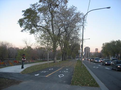
Montreal as a model for bicycle access to and within parks.  In terms of bicycling access, Montreal's network of cycle tracks, both on streets and to and from parks, and within parks, is a model for DC.  Montreal (and the Province of Quebec) has the most extensive cycle track and bike path ("piste cyclable") network in North America.
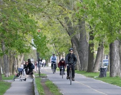
Piste cyclable/cycle track, Parc LaFontaine, Montreal
Piste cyclable/cycle track within Parc LaFontaine, Montreal. Montreal Gazette photo.

Even there, it's not always perfect.  For example, the Rachel Street East cycle track bordering Park La Fontaine had design issues which contributed to accidents.  But the path has been redesigned, with a concrete median added, along with widening and other improvements such as trees, which will provide shade ("Rachel St. no longer collision trap," Montreal Gazette).
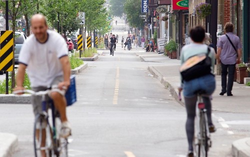
Cyclists ride along the newly widened bike path on Rachel Street, Montreal
Rue Rachel/Rachel Street cycletrack.  Allan McInnis, Montreal Gazette.

Still, bike access to and from and within Park La Fontaine is a good illustration to DC and the National Park Service of how to provide great bike access to major parks within a city at the single park scale, while the general practice within Montreal and the province shows the value of a more extensive bikeway network, which should be a top priority for DC both transportationally and in terms of providing multiple ways for people to access "local" parks.
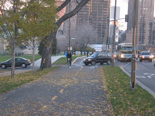
Parc avenue bike path - watch out for cars when crossing Duluth.
Parc Avenue bike path.  Image from Cycling Fun in Montreal blog.
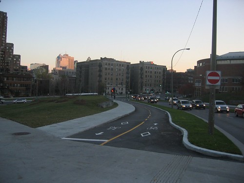
The rebuilt Parc/Pine (pins) intersection, with new bike path.
The rebuilt Parc/Pine (pins) intersection, with new bike path.  Image from Cycling Fun in Montreal blog.
piste cyclable avenue de Parc avenue bike path
Parc avenue bike path.  Image from Cycling Fun in Montreal blog.

Planning for access by foot and transit.  And of course, equivalently robust access needs to be provided for people on foot, and by transit as needed and identified.  The comment thread in the above-cited GGW entry, "It's nearly impossible to get into one of DC's national parks by foot or bike," has many good suggestions for pedestrian access to the C&O Canal National Park.  But this consideration needs to be extended systematically to all of the federal park spaces in the city, not just that one park.

Water access.  The Anacostia Watershed Society has been a strong advocate for boat access to the National Arboretum and Kenilworth Aquatic Gardens, and by extension to other parks along the Anacostia River.

WRT the above-mentioned issue of Roosevelt Park, while it is pretty small compared to Governors Island in New York City, access to the latter park has been facilitated by the creation of a ferry system run by the National Park Service  (But probably access could be integrated from Memorial Bridge as well.)

Transit access. Transit access is important too, because many of the city's NPS parks are situated at the edges of the city, and they can be hard to reach.  Once you're there, access on foot or bicycle may be decent, but getting there is a problem.  Transit access would facilitate park use.

Past writings on transit access and the National Mall include "A National Mall-focused heritage (replica) streetcar service to serve visitors is a way bigger idea than a parking garage under the Mall" and "New DC Circulator route serving National Mall reminds us that we are neglecting connections from west to east and fail to adequately connect Georgetown to the National Mall."

Again, this issue should be considered more broadly, beyond the National Mall, across the network of park assets in the city.

Labels: , , , , ,

Wednesday, January 21, 2015

Canadians are different than "Americans" when it comes to weighing choices about where to live

Well, at least residents of Greater Toronto are different.  The Toronto Star reports in "Buying a cheaper home outside Toronto may not pay off: Homebuyers should consider the high cost of commuting in the GTA when deciding where to live, says a study by Pembina-RBC," on a study published by the Pembina Institute, 2014 Home Location Preference Survey: Understanding where GTA residents prefer to live and commute, which looks at neighborhood preferences in terms of the cost of housing and cost of transportation.

From the article:
In the study, the likely selling price and carrying costs of each of those potential homes is calculated along with the lifestyle and financial implications of the different locations. The case studies showed that the most lifestyle friendly home choices in terms of walkable neighbourhood, amenities and shorter commute times aren’t always in downtown Toronto. They are also found in 905-area hubs such as Oakville, Port Credit and Markham Village.

Sometimes the difference in price, once commuting costs are factored in, is eye-popping. In one case, the report found that a house in Mississauga’s walkable Port Credit neighbourhood would have cost $1,000 a month less than a Milton house priced at $180,000 less.

But that difference depended on giving up one of the family cars in favour of a transit — a radical notion for many homebuyers.
Compared to the US, the results are startling because 81% of respondents prefer "location efficient living" that isn't automobile-centric and dependent, and this preference is true across all age groups.

The report is worth reading page-by-page because they drill down deeper into people's preferences, which is good in terms of dealing with the often "yes, but..." discussions that people have when discussing urban-town-city vs. "suburban" housing choices.

Separately the study provides four interactive case studies showing the economic costs of various housing and transportation combinations.

Key Findings:

1. GTA homebuyers prefer walkable, transit-friendly neighbourhoods to car-dependent locations

- When housing costs are not a factor, 81% of respondents would choose to live in an urban or suburban neighbourhood where they can walk to stores, restaurants and other amenities, and where they can access frequent rapid transit. They would choose these neighbourhoods even if it meant trading a large house and yard for a modest house, townhouse or condo.

2. Most homebuyers choose a location based on price rather than preferences

- Affordability is a primary consideration; over 80% of respondents choose a neighbourhood because that is where they can afford a home.

3. Walkable, transit-friendly suburbs are becoming more popular

- When the cost of housing is not a factor, only 19% of respondents would choose a suburban location with a large home and yard, but where a car is required and commuting takes more than 30 minutes.

- By contrast, 42% of respondents would choose a modest house, townhouse or condo in an urban or
suburban location that is walkable, and where it is possible to commute by rapid transit.

4. All age groups and family types prefer location-efficient living

- If cost were not an issue, all age groups would prefer to live in a location-efficient city or suburb, with 82% of respondents over 60 and 84% under 35 exhibiting that preference.

5. Understanding transportation costs makes homebuyers more likely to choose a walkable,
transit-friendly neighbourhood

- Homebuyer preferences shift when they are told that they can save a minimum of $200,000 over
a 25-year period by giving up one household car and walking, biking or taking transit.

- When informed of these savings, 60% of respondents would choose to live in an area with easy access to rapid transit, even if they could only afford a smaller home.

- Only 36% of respondents would choose a larger home in an area without access to rapid transit

Island Press - Option of Urbanism Investing in a New American Dream - Christopher LeinbergerThese results are in line, but more pronounced, compared to the findings by Christopher Leinberger as discussed in the book Options of Urbanism, where he writes that 30% of people prefer city-town living, 40% prefer traditional suburbs, and 30% are happy to choose either, depending on what is available at the time.

Similarly, they remind me of Kyle Ezell's thesis in the out-of-print book Get Urban, where he argues that you don't have to live in Manhattan to be able to live an urban experience.  And note that increased demand to live  in the center of cities is being experienced across the US, in cities like Nashville, Memphis, Detroit, etc., even if other parts of center cities languish.

And as the study makes clear, in Greater Toronto anyway, people don't have a hard time figuring out that walkable urban places, what Leinberger calls "WalkUPs" in other writings, aren't exclusive to center cities.

Note that in the US, while recommended housing costs tends to be around 30% of household income, transportation costs are 20% of household income.   According to the Housing + Transportation Affordability Index from the Center for Neighborhood Technology:
The traditional measure of affordability recommends that housing cost no more than 30% of income. Under this view, three out of four (76%) US neighborhoods are considered “affordable” to the typical household. However, that benchmark ignores transportation costs, which are typically a household’s second largest expenditure. The H+T Index offers an expanded view of affordability, one that combines housing and transportation costs and sets the benchmark at no more than 45% of household income.
And while it doesn't seem to have gathered a lot of traction, the Location Efficient Mortgage concept, developed by the Center for Neighborhood Technology at least 10 years before they developed the Housing + Transportation Affordability Index is designed to allow households to buy "more expensive houses" because it takes into account a lowered cost of transportation.

Labels: , , , ,

Monday, March 03, 2014

Recent snow and cancellation of bus service

I do find it surprising that Metrobus did not run today and that a goodly portion of Metrobus service will not be running at least at the start of the day tomorrow. There wasn't that much snow.

From "Agenda setting: snow clearance in the walking-biking-transit city":

1. The city needs to develop a plan for "maintenance of way" so that citizens can get to schools, libraries, transit stops, transit stations, and local commercial districts, despite snow conditions. This is especially necessary for the one mile radius areas around subway and train stations.

3. And the city needs to adopt specific policies and practices with regard to snow removal from bus stops as well as from bicycle trails that are also used for transportational purposes.

6. The city needs to prioritize snow removal on bus routes, so that even if the aboveground transit stations are closed, WMATA could still run, safely, bus service on most of the routes.

And WMATA needs to define a snow schedule for buses, based on the amount of snow (in inches).

Granted some routes, because of hills and other conditions, might not be able to run, but more routes should be running than these:
32 and 36 (Wisconsin Avenue), 52 and 54 (14th Street), 70 (Georgia Avenue), 90 and 92 (Florida Avenue/8th Street/Southeast), A6/A8 (Anacostia-Congress Heights-Downtown DC), S2 (16th Street), X2 (Benning Road/H Street).


Labels: , , , ,

Friday, December 06, 2013

Stadiums (and arenas) and cities versus suburbs: Atlanta


Image from Ballparks of America.

I guess I was distracted, because in the previous piece I forgot to discuss recent events in Atlanta, when earlier in November, the Atlanta Braves baseball team announced that they are leaving the city and moving to the suburbs, which is counter to the trend -- at least for baseball, basketball, and hockey -- of teams relocating to center city locations.

-- "Stunning news: Atlanta Braves moving to Cobb," Atlanta Journal-Constitution
-- "Atlanta Braves move to suburbs approved," CNN
-- "Like it or not, Braves' planned move understandable," Atlanta Journal-Constitution
-- "The Atlanta Braves' Move To Cobb County Is About Race, Not Transportation," International Business Times
-- "Your daily jolt: The threats on both sides of the Atlanta-Braves negotiations," Atlanta Journal-Constitution
-- "13 Ways Of Looking At The Atlanta Braves' Move To The Suburbs," Forbes Magazine

Note that the issue of sports teams and economic development is tricky.

1.  As discussed in the previous post, at the metropolitan scale, teams don't add to economic activity, merely substitute for other forms of entertainment.

2.  However, stadiums and arenas can contribute positively, at least in some ways, to urban revitalization at the micro scale of a sub-district of a community.

3.  But contribution is dependent on how well the facility integrates into existing urban fabric, if it extends urban fabric in positive ways, and if the scheduling of events is done in a manner that  allows for spending at nearby businesses that aren't directly affiliated with the team.  (For "early" events, people go to the facility directly from work, and buy food from the facility.  Although many sports arenas and stadiums are significantly upgrading their food offer, and incorporating more locally owned firms and brands.)

Like my point about Walmart not really being an "anchor" because their business model discourages customers from spending money anywhere else (except for prepared meals), increasingly sports events are scheduled in a manner that discourages patrons from consuming food elsewhere--at least before the event, but afterwards, except on weekends, people aren't likely to hang around and spend money anyway.

4.  The ability of teams to contribute at the micro-level to local economic activity is also dependent on how many events are held, the success of the team--even the Atlanta Braves, one of the most successful teams in baseball, only ranks 13th in attendance, whether or not the team successfully prevents the locality from assessing admissions taxes on tickets, and how much money the team is able to extract/extort from the locality for building the facility.

I would argue that baseball, which has 81 games in the regular season, and arena-based sports like basketball and hockey, especially if the two sports are offered in the same arena, have greater financial contribution than football--which has 11 games a year and the stadium typically sits empty the rest or the time--and to some extent soccer--soccer has more games than football and the stadiums cost a lot less than football--which should be positive, but soccer is still in development mode in the US compared to the other sports, so there is a limited track record for determining how well teams contribute economically at the sub-metropolitan scale.

5. The ability of teams to contribute positively to cities is in part a function of good transit systems, which allows patrons to get to events without having to drive, which allows more of the area around the facility to be developed, because of the reduced need for parking lots, and creates less traffic problems.

Football contributes less well on this dimension because of the tailgating phenomenon--people coming to the game hours before it starts, and partying-cooking int he parking lot.

The move by the Braves and its implications

The Atlanta metropolitan area is significantly sprawled and car dependent.  Heavy rail transit (MARTA) is not widely used.  While there are urban intensification and revitalization efforts in the city, such as at Atlantic Station and in the vicinity of Georgia Tech and Emory Universities, economic development trends there still favor the suburbs ("Atlanta Braves Prove New Realities In Stadium Decision," gondeee blog).  Organizations, even the main newspaper, the Atlanta Journal-Constitution, continue to move out of the Downtown and the city.  (The newspaper is now located in suburban Dunwoody.)

Turner Field is seemingly close to Downtown, less than a couple miles away, but is not well connected to the urban fabric, being framed by two freeways and surrounded by parking lots, and is 3/4 mile from a MARTA station--not terribly far, but certainly not connected in the way that AT&T Park in San Francisco enjoys transit service--and is in a neighborhood that doesn't have the same fabric and place value of areas like Wrigleyville in Chicago or Fenway in Boston.
cm_giants_2
Photo by Mike Kepika of the San Francisco Chronicle. People leaving the streetcars to see a Giants game at PacBell Park in 2005.

Although plenty of other in-city stadiums, such as in Seattle, the Bronx or Queens boroughs in NYC, or even in DC--the area around that stadium is in the midst of redeveloping--don't offer experiences comparable to Wrigleyville or Fenway either.

Note how well San Francisco's AT&T Park integrates into the urban fabric.
SBC Park, San Francisco
SBC Park opened in 2000 as Pacific Bell Park. By far the most breathtaking of the 18 major league ballparks that have opened since 1989, it glories in its tight perch between a big city and a wide-open bay. SF Chronicle photo by Michael Macor.

The Atlanta Braves move follows the movement of other cultural institutions out of Atlanta proper ("Braves move seen as a blow to Atlanta and a signal of a new era," New York Times), and the failure of a transportation and transit sales tax initiative in 2012 (past blog entry, "Failure of the transit-roads sales tax measure in Metro Atlanta"), which also communicates that as far as Atlanta is concerned, and unlike many other US cities, pro-city trends are not positive.

The IBT article cited above asserts that the move is partly about racism.  Atlanta is an African-American majority city (and small in population, 2/3 the population of DC, which is small too) and the fan base for the Braves is mostly white and suburban.  The article points out that while the team claimed that lack of great transit was an issue in their move, they chose a new location with no existing transit connections and a dim likelihood for getting such service.  The Forbes.com piece makes similar points, focusing more on the spatial organization of racial segregation in the Atlanta region.

Other reportage makes the point that the Braves resented how much money--$1.2 Billion--that will go to a new Atlanta Falcons football stadium, and that they weren't offered a comparable package--in part because the city didn't have any more money, and because the city thought that the baseball team wouldn't move out of the city.

Although the reality is that the financing issues are complex.  The Falcons already play in a facility owned by a state agency while Turner Field is privately owned, and tax funding streams are already in place to support the publicly owned football stadium.

Cobb County is likely to provide about $250 million towards a stadium, when the City of Atlanta was likely to provide no more than $150 million

This is important to think about because if cities are going to continue to be extorted by teams in terms of subsidies, and there is no reason to think that this will change any time soon--Congress would have to step in and pass laws forbidding local funding, which will never happen--then they are going to have to make hard choices about which types of projects to fund, and which projects not to fund.

Probably it would have made more sense for Atlanta to significantly invest in baseball and in improving transit connections and the neighborhood around the stadium that could have upwards of 100-110 events each year, versus a football stadium that likely has fewer than 20 events annually.  But because of how the respective stadiums are owned, such decisions couldn't happen as quickly as the Braves wanted.

Interestingly, the NYT piece makes the point that the area of Cobb County where the stadium will be moving to is intensifying and becoming urban in ways that Atlanta isn't (not unlike how Tysons Corner in Northern Virginia and White Flint in Montgomery County, Maryland are changing their spatial organization to become more urban and less car dependent).

Other stadium and arena projects to watch

1.  Richmond.  Is still trying to build a new minor league baseball stadium in the Shockoe Bottom district downtown.  While I think that would be great, the area is constrained physically and a stadium there could pose tough transportation issues.  Plus, the current stadium is owned by the Richmond Metropolitan Agency, a multi-jurisdiction agency and it could be difficult to get the county members to sign off on such a change.

2.  Brooklyn.  The sky hasn't fallen with the opening of the Barclays Center.  It will be interesting to see how things develop there, especially by contrast to the areas around baseball stadiums elsewhere in NYC, which by contrast to similar districts in Chicago and Boston, aren't happening places.

3.  Plus, in Manhattan, the conditional use permit for Madison Square Garden was approved for a 10-year term, not indefinitely, which could lead to a plan for changes in the Penn Station area of the city.  With a new mayor not necessarily as focused on land use intensification, it will be interesting to see how this plays out.

4.  Sacramento.  There is opposition to public funding of a new arena for the Sacramento Kings basketball team, which had been on the cusp of being sold and moved to Seattle.  The team was sold and plans for a new Downtown arena and adjacent development are underway.

5.  Seattle.  One of the funders of a effort to put an anti-funding referendum on the Sacramento ballot was the person who aimed to buy the team and move it to Seattle, which has poisoned his relations with the NBA.  And Mayor Mike McGinn, who was supportive of the proposed move of the Kings to Seattle, was not re-elected.

6.  DC.  Plans to trade land in an off the books transaction to avoid bond funding limits to build a soccer stadium continue to move forward, although are behind schedule.

7.  In "Devil of a Stadium Plan" the Wall Street Journal reported on how Arizona State University in Tempe Arizona is able to trade land that it owns to developers in return for their building the university a new football stadium.

Labels: , , , , , ,