Planning subway expansion in a coordinated and planned fashion
The Washington Business Journal reports, in "Gerry Connolly, Jim Moran push rail extension in transportation bill" that Northern Virginia congresspeople are pushing an earmark for planning extensions to the WMATA subway system.
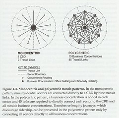
As Steve Belmont points out in Cities in Full, the Washington Metropolitan subway system is polycentric, and is focused on sprawl promotion, rather than intensification and coordination of land use and transportation optimality at the core.

WMATA polycentric rail system -- Belmont.
However, it happens that at the core of the system in DC, where 29 stations cover a roughly 15 square mile area, and to some extent along the Rosslyn-Ballston corridor in Arlington County, Virginia, the system operates monocentrically, and gets significant mode shift to transit (along with walking and bicycling trips), intensification of land use in ways that don't overstress extant infrastructure, and significant reductions in congestion on surface streets.

Monocentric and Polycentric transit patterns -- Belmont.
But for the most part, Gerry Connelly of Fairfax County and Jim Moran of Alexandria-Arlington, aren't promoting what Belmont calls a recentralization of commerce, housing, and transportation, they are promoting furtherance of deconcentrated land use.
From the article:
Reps. Gerry Connolly and Jim Moran, both Democrats, want Congress to earmark funds for a feasibility study and preliminary engineering for major extensions of the Orange, Blue and Yellow lines. They estimate the study would cost about $20 million.
“The point of my bill is to jump-start the discussion about extending these lines,” said Connolly, a former Fairfax County Board of Supervisors chairman. “By the time it’s completed in 2013, the rail to Dulles will have taken 51 years from the first discussion to the first passenger. I don’t want another 51 years before there are more extensions.”
Under Connolly’s plan, the Orange Line, which now ends in Vienna, would continue along Interstate 66 to Centreville. The Blue Line would extend from Franconia-Springfield along I-95 to Prince William County. And the Yellow Line, which ends at Huntington, would go to Fort Belvoir and Woodbridge. The Purple Line, still in the planning stages, would cross Montgomery County and move around the Beltway.
The Purple Line extension into Virginia is a good idea, and does promote concentration of land use and transportation optimality on the core.

To the best of my knowledge, the idea for the Purple Line was first expressed in a Washington City Paper cover story by Mark Jenkins, published somewhere between 1990 and 1992. This graphic of a fully circumferential purple line comes from the Sierra Club Metro Sprawl campaign. While Maryland has been working diligently on creating a Purple Line light rail system in Montgomery and Prince George's County, Fairfax County has not responded similarly, and therefore planning of an extension of the line westward from Bethesda into Fairfax County is not underway.
But...
1. In 2003, WMATA devolved expansion planning to the separate jurisdictions.
2. So, while VA and MD might want to extend the outward length of the subway system, really this becomes an issue of extending polycentrism and supporting sprawl, or not.
3. So, if the jurisdictions are responsible for expansion planning, DC and Arlington need to plan also, and to link agreements for extensions of the outward length of the system with expansion of capacity at the core of the system.
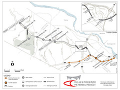
4. For example, how the hell could the Silver Line extension have been approved without requiring an expansion of capacity to cross the Potomac, from Rosslyn to DC?

Dulles Metrorail - Map and Stations.
5. What should have happened was the Silver Line extension should have been linked to the old (2001-2003) plan to separate out the Blue Line within DC and across the Potomac, to add redundancy and capacity in the core of the system, adding subway service coverage within DC, especially to in-demand locations, and an additional river crossing.

Proposed changes for the WMATA system, 2001 (separated blue line map). Washington Post graphic.
This map, graciously produced for this blog in 2008 by David Alpert of Greater Greater Washington, shows the Virginia Silver Line extended into DC along the lines proposed by the WMATA planning department in 2002.

(We should have thought to include a Purple Line extension into Virginia...)
6. By devolving authority to jurisdictions to plan expansions separately rather than in a coordinated fashion, the subway system runs the danger of becoming balkanized and extended in an unbalanced way.
7. DC should not agree to extensions of the lines beyond their current termini unless planning for capacity expansion and redundancy of the core of the system is planned simultaneously.
8. And DC and Arlington need to influence the Connolley-Moran WMATA extension earmark so that it includes planning for capacity extension at the core of the system, otherwise the plan is not a winner.
------------------
For more about how to think about metropolitan transit planning, see:
-- The (Meta) Regional Transit Network and transportation "vision" maps
-- The DC Transit Network
-- Updating the mobilityshed concept
-- USDOT and NCPC, not GSA, should appoint members to the WMATA Board.
Labels: smart growth vs. smarter sprawl, sustainable land use and resource planning, transit, transit and economic development, transportation planning


0 Comments:
Post a Comment
<< Home