Rebuilding Place in the Urban Space

"A community’s physical form, rather than its land uses, is its most intrinsic and enduring characteristic." [Katz, EPA] This blog focuses on place and placemaking and all that makes it work--historic preservation, urban design, transportation, asset-based community development, arts & cultural development, commercial district revitalization, tourism & destination development, and quality of life advocacy--along with doses of civic engagement and good governance watchdogging.

Monday, September 04, 2023

Sprawl washing/sprawlwashing

The term "greenwashing" is used to refer to organizations that announce sustainability initiatives as a way to detract from their generally poor practices.

I have been critical about the announcement of the "Utah City" development in the Vineyard community of Utah County, Utah, which will be new urbanist, mixed use, aims to leverage a commuter railroad station, etc. ("Utah City breaks ground, a very ambitious TOD: A new transit-oriented development in Utah is planned with the density and amenities of a big city downtown," Congress for the New Urbanism).

It's 700 acres.  A tad over one square mile.

Utah County has over 2,000 square miles of land--I don't know how much is undevelopable because it's mountains.  Salt Lake County 800.  Davis County 634.  Again for Davis and Salt Lake Counties, a goodly amount of land is tied up in mountain ranges

Still, that's almost 3,500 square miles, that is developed as classic sprawl ("Study: Utah has second-fastest urban sprawl," Salt Lake Tribune, 2014).

Weekend travelers join the traffic on I-15 near Point of the Mountain near Draper 
Thursday, Aug. 30, 2018. Photo: Steve Griffin, Deseret News

So a development or two here and there, using nonsprawl principles, doesn't make any difference.  Although people criticizing my stance say it's an important step forward.

Meanwhile, Utah faces incredible drought (the Governor calls for praying for rain, "Utah governor asks citizens to pray for rain to end drought," AP), isn't expanding the Trax light rail system, does plan to widen I-15, continually fails to address air quality issues, is in danger of losing the Great Salt Lake ("‘Last nail in the coffin’: Utah’s Great Salt Lake on verge of collapse," Guardian), is a state dedicated to resource extraction especially of fossil fuels, etc.

Labels: , , , ,

Monday, December 03, 2018

Smart Prosperity Institute (Canada) report/infographics on spawl

-- Report and related materials, The Cost of Sprawl


Labels: , , ,

Saturday, June 16, 2012

Smart Growth vs. Dumb Growth | Urbanism vs. Suburbanism -- politics in Clackamas County, Oregon

In terms of the previous discussion about pro-sprawl forces being engaged in a permanent campaign ("The right's permanent campaign in favor of their pro-sprawl (and anti-Democratic Party) message"), it is no surprise that "conservative" groups (the Oregon Transformation Project is primarily funded by timber industry interests) are donating money to certain Clackamas County political campaigns, and putting out the message that these candidates will support good county values of no development versus the creeping urbanism of Portland.

From "Regional transportation, cooperation at stake in three Clackamas County commission races" in the Portland Oregonian:

A new term has entered the political lexicon of Clackamas County: Portland creep.

Those two words, intended to denote density, crime, congestion and tax-happy bureaucracy, appear on two can't-miss billboards along Interstate 205 near Gladstone. The conservative Oregon Transformation Project's political action committee paid for the billboards to support a slate of candidates who, if elected, would take majority control of Clackamas County government.

The new phrase also sums up what's at stake in this year's race for three seats on the five-member Clackamas County Board of Commissioners: Should the county be a cooperative partner in regional efforts or become more politically independent and fiscally conservative? ...


The county's largely conservative, grass-roots movement already chalked up two significant reversals of county policy over the past year.

In May voters resoundingly approved a referendum that reversed the commissioner-approved $5 annual vehicle registration fee intended to help build a new Sellwood Bridge. In November, voters overwhelmingly supported requiring countywide approval for new urban renewal districts in unincorporated parts of the county, a move that effectively kills urban renewal.


The pro-sprawl forces produced a damn good but misleading--because they aren't for flowers, they are for anti-planning--billboard to communicate their message.  See "John Ludlow and Tootie Smith, Clackamas County commission candidates, receive contributions from Oregon Transformation Project" from the Portland Oregonian.
Oregon Transformation Project political billboard
A billboard along Interstate 205 near Gladstone urges Clackamas County voters to support Tootie Smith, John Ludlow and Jim Knapp, candidates for the Clackamas County commission. The billboard was paid for by the conservative group Oregon Transformation Project.

The organization has also helped to fund a ballot measure that will require public voting on all rail transit measures in Clackamas County ("Clackmas County won’t fight rail vote: County employees will continue to issue TriMet permits" from the Portland Tribune), which is an attempt to limit metropolitan transit expansion in the Portland region.  That election will be held September 18th.

In the May 15th primary election, one of the three candidates, Jim Ludlow, who ran for Board Chair, did win.

The issues in Clackamas County are somewhat comparable to Loudoun County in Northern Virginia, where expansion of the subway rail system to Dulles Airport and then beyond into Loudoun County is seen by pro-sprawl forces as a key element of what they could term "Urban creep" if the pro-sprawl forces put some money into a good ad agency.  See "Loudoun may have votes to OK Metro line" from the Washington Examiner.

Labels: , , , , , , ,

Tuesday, May 22, 2012

Recapping new urbanism

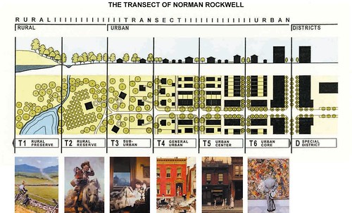
The Transect of Norman Rockwell
The New Urban Transect, using images by Norman Rockwell to illustrate the various zones.

A couple weeks ago, the annual conference ("congress") for the Congress of New Urbanism was held in West Palm Beach, Florida. 

In advance of the meeting, the newsletter Better! Cities and Towns ran a three-part series by Peter Katz on the beginnings of the movement and the development of a relationship with HUD that led to the HOPEVI program which spearheaded redevelopment of public housing projects.  See "CNU at 20: A recollection," "The origins of the Congress for the New Urbanism," and "HopeVI and the inner city."

Interestingly enough, according to Katz' articles, some of the schisms in the movement today over what we might call new suburbanism and the development of greenfield tracts far from urban centers, but with new urban principles based on the Charter of the New Urbanism vs. focusing redevelopment at the core of a metropolitan region, with a focus on "infill" apparently were present at the beginning and still aren't resolved.

Erin Chantry, an urban designer at the firm Tindale-Oliver & Associates and blogger (At the Helm for the Public Realm) attended the congress and wrote eight dispatches related to conference sessions and her reactions

Her dispatches are a good introduction to the basic principles underlying smarter growth and well worth a read.

Labels: , , , , , , ,

Tuesday, February 14, 2012

"Nihilistic selfishness": Part 2

Last summer, UK Planning Minister Greg Clark called opposition to changes in planning processes by the National Trust and the Campaign to Protect Rural England as "nihilistic selfishness." To me, the people who are "nihilistically selfish" are those who advocate for changes that could have devastating effect on rural landscapes and builtscapes . See the blog entry, "Nimbyism: Standing up for what's right or "nihilistic selfishness"?."

Yesterday, the Campaign to Protect Rural England and the National Trust followed up on Minister Clark's criticism by releasing an economic study, ‘Inexpensive Progress? A framework for assessing the costs and benefits of planning reform’.

From the CPRE website:

The report, prepared by Vivid Economics, finds that although there have been a few studies of the costs of the planning system, the claims made on the back on them have been overstated - and very little has been done to measure the benefits that good planning delivers. It concludes that while there are costs in some sectors, there is no evidence that planning has large, economy-wide effects on productivity or employment and that the draft National Planning Policy Framework (NPPF) is unlikely therefore to have much effect on growth.

It's typical that arguments concerning changes in policy are justified for their presumed positive impacts on growth and economic development, but often that is merely cover for various economic interests who have been advocating for the changes for a long period of time.

As Neil Sinden, director of policy for CPRE says in this article, "Planning reforms would not promote growth, says report," from the Independent:

"Effective planning should not be seen as a choice between growth or the environment. As this report argues, the aim of planning should be to secure long-term well-being."

The current issue of the CPRE magazine focuses on the issue of "planning reform" with these articles:

Labels: , , , ,

Tuesday, January 10, 2012

Planning for intensity of land use: the question is at what scale are we planning?

Kaid Benfield at NRDC's Switchboard blog, has a post, "A strong case for a rail- and transit-oriented California," that raises some interesting issues about scale of metropolitan and regional development. He calls our attention to research (Charting our Future, Vision California) and an op-ed, "Why California needs high-speed rail," in the San Francisco Chronicle by Peter Calthorpe that suggests that high speed rail can be the fulcrum to repattern land use in ways that intelligently allow the state to absorb a projected new residents.

From the blog entry:

The envisioned benefits would come from a “growing smart” scenario that would leverage the construction of a planned high-speed rail network with smart land use around and near the network's stations and additional intra-city transit systems. The scenario would include a more balanced housing mix, more infill development, and greater transportation options than under a business-as-usual scenario, which assumes a continuation of dispersed, auto-oriented development patterns (albeit with continued modest improvements in automobile, building, and energy generation efficiency). Even greater comparative benefits would be realized under a more ambitious “green future” alternative.

In the 2009 entry, "Second iteration, idealized national network for high speed rail passenger service," I discussed how transportation planning within the U.S. should occur on five distinct but interconnected levels:
- international (connections between countries);
- national (such as the Interstate Highway system or the proposed High Speed Rail Initiative);
- regional or multi-state (freeways sure but also railroads, such as passenger railroad service in NY, CT, NJ, and PA) [including inter-city bus service];
- metropolitan such as the subway and bus system for the Washington metropolitan region, which is anchored by the WMATA system and the VRE and MARC railroads; and is supplemented by
- submetropolitan transit networks at the suburban and city levels.

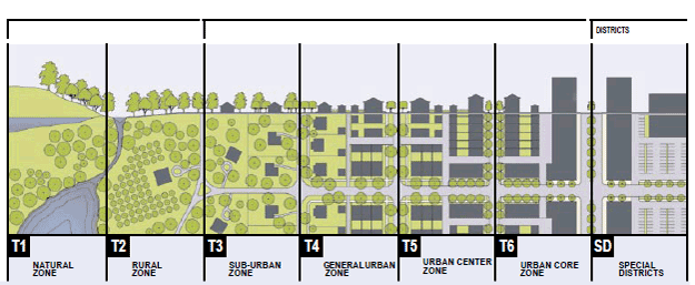
Interestingly, at the local level, I am often critical about attempts to do "transit oriented development" at commuter railroad stations in the greater region, because for the most part these stations are on the outskirts of their respective metropolitan areas, in areas where the land use pattern and context, from the standpoint of the New Urban transect, is not very dense (T2/T3).
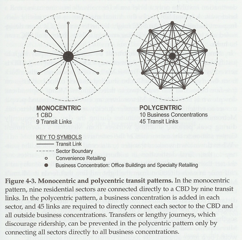
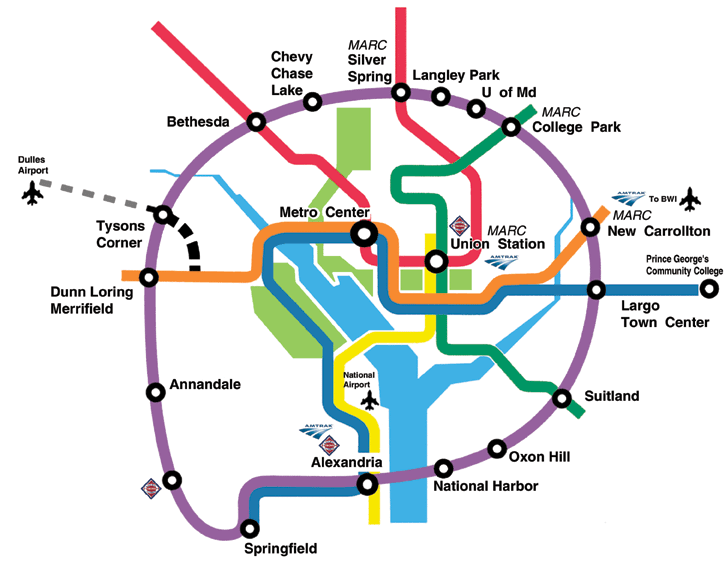
Monocentric and Polycentric transit patterns -- Belmont
Monocentric and polycentric transit patterns, from Belmont, Cities in Full.

A related issue is whether or not the railroad stations are in fact key elements of their local communities or disconnected pods used by people from elsewhere in the region. For example, while adjacent to the Arbutus community in Baltimore County, the highly used Halethorpe MARC railroad station is used not by residents from the immediate neighborhood, but people who drive to the station from around the metropolitan area who appreciate that the station is easily accessible from the Baltimore Beltway (I-695).

If you were to develop Halethorpe intensively for "smart growth" reasons, the desired impact likely would not occur, because the land use around the station is low density single family residential, with a small town center.
Transect diagram
Transect diagram.

But at the regional scale, is it still in fact better to promote development around railroads, such as the proposed high speed rail system in California, rather than via highways, such as the proposed Virginia I-95 bypass proposed by groups such as by the pro-roads Northern Virginia Transportation Alliance?

Calthorpe outlines the difference in development paradigms in his op-ed:

Transit-oriented development built around high-speed rail and local transit would be denser. Detached single-family homes would drop from 62 percent of our state's housing to just over half, with the difference filled by townhomes, apartments, lofts and bungalows. Given that large-lot suburban homes now have declining value, this is a reasonable shift in housing type, ultimately making housing stock more affordable.

This shift also results in 67 percent less developed land and would save prime farmland in the Central Valley and key open space and habitat in the coastal regions of the state. The more compact future means smaller yards to irrigate and fewer parking lots to landscape, saving an average of 3.4 million acre-feet of water per year - enough to irrigate 5 million acres of farmland in our water-poor state.

In the transit-oriented development future, average vehicle miles traveled per household would be reduced 40 percent, the equivalent of taking 18.6 million cars off the road. There would be fewer roads and parking lots built, less runoff water to be cleaned and stored. New highway construction is reduced by 4,700 miles, saving the state about $400 billion.


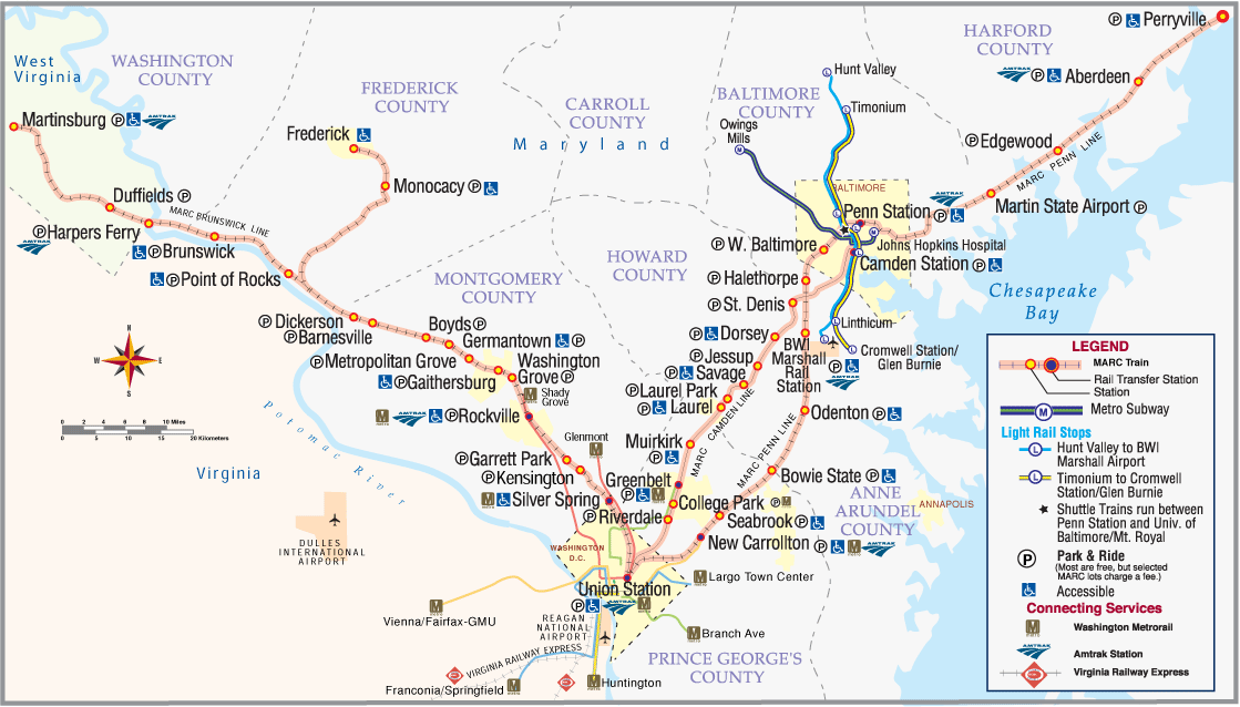
MARC Commuter railroad system map, Maryland/West Virginia
MTA Maryland/MARC commuter railroad Map

The question becomes is it appropriate to intensify those areas, because for the most part those areas aren't developed now? Does this development support monocentric or polycentric development patterns, does it add to sprawl, rather than containing sprawl?

This came up on the urbanists e-list, where I made the point that in the context of rural opposition to PlanMaryland, the state of Maryland plan that coordinates and directs state investments to extant areas rather than undeveloped areas, a "new urban" residential development in St. Mary's County or Carroll County, would be considered smart growth at the scale of the county, but sprawl in the context of the metropolitan region.

See "Maryland To Offer Preferential Funding For Smart Growth" from WAMU Radio, this letter to the editor by a St. Mary's County Commissioner in the Baltimore Sun, "PlanMaryland is a bureaucratic takeover," and "PlanMaryland concerns local officials" from the Salisbury Times.

In fact the regional scaled Smart Code would call such developments sprawl. But on the other hand, you can argue that at the regional and multi-regional scale, this kind of land use change might in fact be a good thing.

I'm not going to argue with the Vision California research or Calthorpe's points, even if I am making the point that at least in the DC region, rather than focus on creating pods of development at commuter railroad stations we should be focusing on intensifying land use in areas served by transit systems, which operate at the metropolitan and sub-metropolitan scale, rather than railroads, which operate at the regional and multi-regional scale.

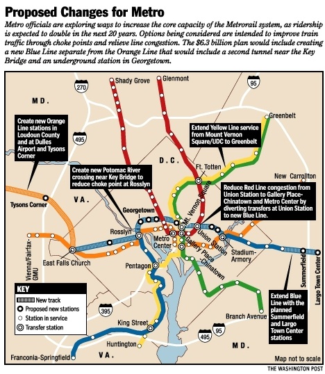
And, at the same time, we should be focused on intensifying investment in transit systems, not so much focusing the systems outward in more polycentric-development supportive ways, in the DC region, such as proposals to extend the Metrorail system to Prince William County or to BWI Airport, but by adding to the system within the core of the region, such as the "separated blue line" proposal providing additional service in the core of the city, or other projects to add better transit service, via the Purple Line light rail project in Montgomery and Prince George's County Maryland, and further extending this concept into Northern Virginia, rather than focusing sprawl-promotion energies on freeways.

Purple Line concept map, Sierra Club
Purple Line Map  DC Metro

Separated blue line map, 2002, Washington Post graphic
Proposed changes for the WMATA system, 2001 (separated blue line)

Labels: , , ,

Tuesday, September 20, 2011

(Sort of a repeat) Without the right transportation planning framework, metropolitan areas are screwed, and that includes the DC area

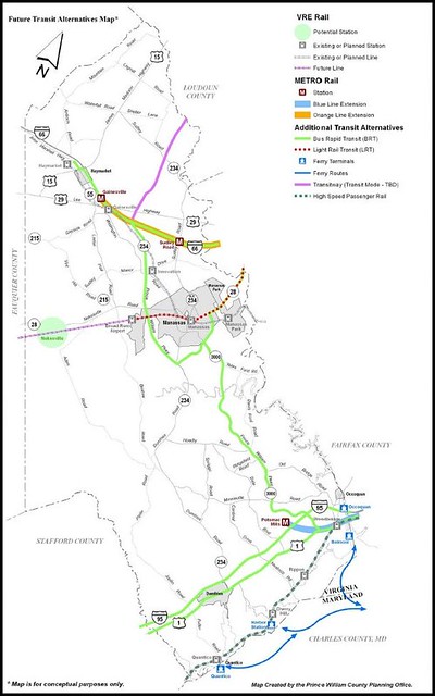
Proposed transit expansion map, Prince William County, Virginia
Proposed transit expansion map, Prince William County, Virginia. From their Master Plan.

The bulk of this blog entry ran on January 14th, 2011, and I have written about this broad issue in the blog since the beginning.

It's worth re-running because today next Monday (September 26th) there is a conference in Prince William County about extending the WMATA heavy rail system there. See "Connolly and elected leaders to discuss Metro extension to Woodbridge" which ran in the Express, as well as the GGW response, "Is a Metro extension to Woodbridge a good idea?."

These past blog entries are also relevant: "Silver Line Metro expansion a classic example of the need to have true regional transportation planning," plus these, specifically about this same issue, "Regional transportation planning and fixed rail service" and "Planning subway expansion in a coordinated and planned fashion."
WMATA extension outward has been an issue for years, with various proposals to BWI Airport, southward on the Green Line from Branch Avenue deeper into Prince George's County, and further into Northern Virginia.

I don't feel like I need to write about the specifics so much, because I have done so before. However, looking at my presentation on Metropolitan Mass Transit Planning: Towards a Hierarchical and Conceptual Framework which is discussed below, I guess I would have to add probably up to 4 slides, first to further discuss Belmont's point about the difference between polycentric and monocentric transit networks; and second, THE NEED FOR SUBURBAN COUNTIES TO PRODUCE ROBUST AND INNOVATIVE AND COMPLETE TRANSPORTATION PLANS, comparable to the Arlington County Master Transportation Plan, but appropriate for their jurisdictions, ensuring that mass transit is covered.
WMATA polycentric rail system -- Belmont
WMATA polycentric rail system graphic, from Steve Belmont, Cities in Full: Recognizing and Realizing the Great Potential of Urban America.

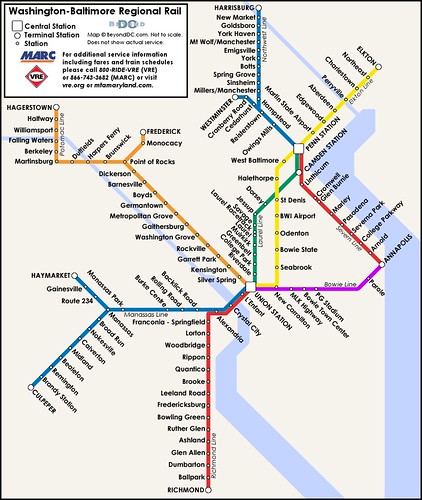
Without a metropolitan scale transportation plan and truly robust county-wide transportation plans for Fairfax and Prince William Counties (the links are to their transportation elements in their Comprehensive plans) this misses the point, especially because heavy rail extensions might not be the best way to provide the necessary level of service--that is, trains and the VRE, which of course, also brings the idea up of needing to plan for passenger rail service on a regional basis too, see "A regional railroad passenger transportation vision for DC, MD, VA, WV and parts of PA" from 2006.."
Proposed map of a Washington-Baltimore regional rail system
Concept and map by BeyondDC.
On the other hand, if PW County joined the regional transit compact, then they'd start having to pay into the system--it might also change the political climate in Virginia generally about the provision of financial support to the WMATA system.

But the service would degrade and frankly, DC should stand up with some guts and vote against any system expansion that it is not tied to system expansion at the core of the city (specifically the separated blue line, but other improvements as well).

Reprint of the January entry starts here:

I wrote ... about "metropolitan planning organizations" generally, and DC's in particular, the Transportation Planning Board of the Metropolitan Washington Council of Governments.

I can't claim to be an expert on how MPOs work. Some are more powerful than others, and act for the most part, as regional planning organizations. I was gonna mention the MPO in Minneapolis, which also runs the transit system and manages the regional water system, and does regional parks planning (even if parks are run by the counties/City of Minneapolis), and contrast that to the TPB, which has the misfortune of covering an area encompassing three "states" (technically DC is not a state) and a more complicated political, organizational, and spatial environment. (Another example might be the regional government in Portland, Metro, which has responsibilities across multiple jurisdictions.)

Then I was going to include as an example to strive to be more like, the Center for Neighborhood Technology, a nonprofit (not an MPO) engaged in a variety of leading edge planning efforts in the Chicago metropolitan area, on environment and various green initiatives and transportation and community development, as an example of how a metropolitan planning organization could be more innovative and expansive in their role as leading metropolitan best practice land use, environment, energy, and transportation planning.

This comes up in the context of leading edge transportation (and land use and environmental) planning in the DC Metropolitan area, and that we aren't doing it. Or at least, the transportation planners aren't in the front of the pack, when it comes to initiate best practices in transportation planning. I think we can safely assume that the creation of Metrorail was more a happy accident that was the end result of an odd set of circumstances, rather than the beginning of a scalar improvement in metropolitan planning generally and transit planning and operations in particular.

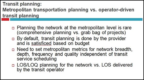
I have a presentation on an idealized framework for transportation planning [which I presented to some academic departments at the University of Delaware in March 2010], and I specifically distinguish between planning for transportation at the scale of a metropolitan area (and regions, and nations, and internationally) and within a metropolitan area (I define a region as encompassing two or more metropolitan areas), at the overall level, within the suburbs, and within the center city, as well as more generalized transportation planning vs. transit planning by the local transit system operator(s).
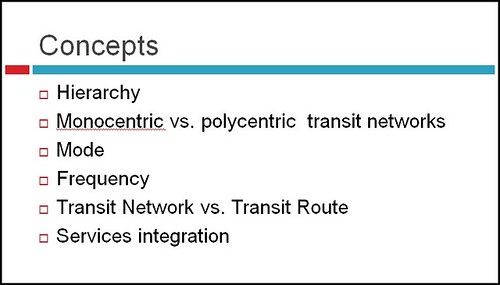
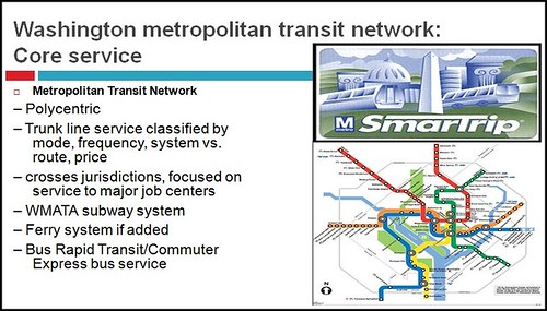
-- Metropolitan Mass Transit Planning: Towards a Hierarchical and Conceptual Framework

Slide, Metropolitan Mass Transit Planning: Towards a Hierarchical and Conceptual Framework
The ideas are based on my observation of how we don't do broad-based transportation planning in the DC Metropolitan area and in response partly to the annual service cuts in response to budget problems by WMATA and the various transit operators.
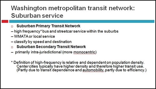
Slide, Metropolitan Mass Transit Planning: Towards a Hierarchical and Conceptual Framework
As far as the plan goes, we don't really have a metropolitan plan as much as a list of priority projects, mostly road-related, from the various jurisdictions.

And rather than focus on making transit work better and having more of it in the areas where transit is more likely to be used, instead most of the metropolitan transit system expansion proposals have to do with extending the system outward, making it even more polycentric, rather than intensifying the transit footprint at the core of the region--the Purple line in Prince George's and Montgomery Counties, and streetcar plans in DC and Arlington and Fairfax Counties excepted.
Slide, Metropolitan Mass Transit Planning: Towards a Hierarchical and Conceptual Framework
Plus, as I blogged in one of my earlier entries in March 2005, counties like Fairfax County need to not rely so much on Metrorail as much as they need to develop a wide-ranging transportation and transit plan of their own. (Maybe they have by now, I can't keep up.)

BeyondDC has a post on this broad problem, "A whole network is better than one line" in the context of the recent bill put forward by Northern Virginian Congressmen Moran and Connolly to study Metrorail expansion. He writes:

While it’s good news that Northern Virginia’s Congressional representation has an eye towards transit (though Frank Wolf’s absence is notable), the bill is a reminder of the fact that for many people in this region the word “transit” is one-dimensional code for Metrorail. This is unfortunate, because while Metrorail is undeniably great, it isn’t the best solution to every transit problem we face. If we could could make the intellectual jump to accept a more diverse collection of transit modes, we would have the means to provide a better and more comprehensive regional transit network, faster and for less money. ...

The issue is that Metrorail is much, much more expensive to build than other transit modes such as commuter rail, light rail, streetcar, and BRT. Although MetroRail extensions to Woodbridge, Fort Belvoir and Centreville might be wonderful in those individual corridors, for about the same cumulative cost we could put light rail on every major arterial street in Northern Virginia and upgrade all the VRE lines to Metro-like service levels, with trains running frequently all day and on weekends.

Basically, if we were a little more open-minded with modes, we could have a transit system that put rail stations within walking distance of almost everyone in Northern Virginia for about the same cost as a couple of Metrorail extensions.


But I would argue that the post while focusing on the right on point that it's far better to target the right kind of rail investment (streetcar, railroad, heavy rail, light rail) should have more directly discussed the broad problem--the need for planning at the metropolitan level, focused on creating, maintaining, and extending a complete and robust metropolitan transit network.

(Over the years I have discussed all the proposals for extending the Metrorail system in Virginia and Maryland, including in this post, which links to many of the articles in the Post and other newspapers on the subject, "Regional transportation planning and fixed rail service.")
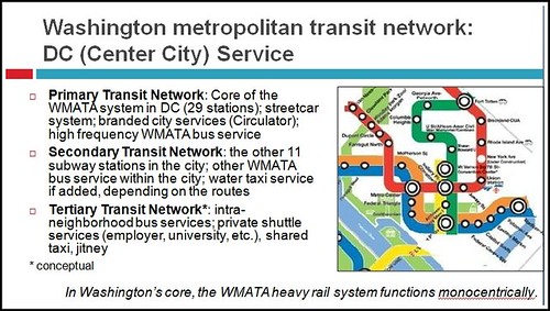
If we were to do true metropolitan-wide transportation (and therefore transit) planning, the specific transit modes take care of themselves, because you are planning for the best possible, most robust total and complete system, not for Metrorail this, or Arlington streetcar that. See the past blog entry for a discussion of the network concept, "Reprint (with editing): The Meta-Regional Transit Network."

And not just on extensions. Note that there are some interesting reports from the Center for Transportation Studies at the University of Minnesota. One report makes the point that the most benefit comes from the first 10 miles of the system, because that area is already likely to be more intensely developed, with the characteristics already in place that support sustainable transportation, ridership, and economic development.


Would that our Congresspeople learn this, as well as the local and state elected officials across the region.
Slide, Metropolitan Mass Transit Planning: Towards a Hierarchical and Conceptual Framework

Slide, Metropolitan Mass Transit Planning: Towards a Hierarchical and Conceptual Framework

Slide, Metropolitan Mass Transit Planning: Towards a Hierarchical and Conceptual Framework

Labels: , , , ,

Tuesday, August 30, 2011

State vs. local control over land use: Maryland edition

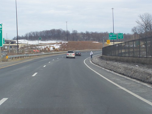
Someone walking along I-495 just across the Wilson Bridge in Maryland
Because the State of Maryland has been working on PlanMaryland, a statewide land use plan, there has been back and forth between counties and the state versus what is appropriate vs. "inappropriate" land use, and about the proper role of the state vs. localities, etc.

Columnist for the Gazette Barry Rascovar has a piece, "It's land use, stupid," which is a reasonable piece on the issue, but it still misses a key point. From the article:

The governor’s determined defense of his controversial land-use plan before the Maryland Association of Counties cut to the quick when he said his plan “is not going to prevent the counties from making stupid land-use decisions. They’re still free to do that. We’re not going to subsidize it.”

In other words, no more subsidies for stupidity.

Such a policy is 40 years late in arriving. But finding a way to put the policy into practice without generating furious protests that influence elections in 2012 and 2014 requires prolonged negotiations. ...

Once again, local opposition is growing against an effort to put some baby teeth in a state land-use plan. Local officials fear heavy-handed state control. They have nightmares of state bureaucrats usurping the traditional zoning and planning roles of local officials.

Who knows what’s best for Frederick, Montgomery or Carroll County? A pointy-headed policy wonk burrowed in a state office building in Baltimore or a local official with intimate knowledge and understanding of a county’s quirks and characteristics?

Can you imagine state planning officials further complicating the many decisions tied to the National Harbor development or adding more complexity to the zoning and planning process for the proposed Science City in Gaithersburg?

In fact, tough state land-use laws might have destroyed James Rouse’s dream of developing a new town on farmland in Howard County. Similarly, Baltimore County’s changes to its zoning laws that allowed for dense population growth in two town centers (White Marsh and Owings Mills) might have been deemed off-limits by earlier state planning czars.

Overcoming the fears of local leaders won’t be easy, particularly at a time when O’Malley also wants to outlaw new septic systems — a move that could have staggering negative implications for many of the state’s less-developed counties.

Still, it is sound policy for the state to tell counties that it will reward them for making sensible land-use decisions that keep population growth within designated areas already served by infrastructure. These counties will continue to get money for school construction, new roads and water and sewer systems.

But counties that insist on promoting sprawl and unchecked development will have to spend more of their own dollars on high-cost public services in those areas.


Rascovar criticizes the possibility of state controls limiting projects like Columbia (maybe an acceptable project), or the creation of growth areas in Baltimore County at Owings Mills and White Marsh, or what is now National Harbor in Prince George's County.

-- Images of I-795/Owings Mills Subway station (AA Roads)

The reality is that all of those developments are classic examples of sprawl and automobile dependence and come at the cost of improving existing areas, and make it that much harder to improve existing areas within Maryland.

They aren't best practice examples of good planning and zoning, but best practice examples of bad planning and the inability of counties to direct land use towards intensification.

While Owings Mills has a subway connection to Baltimore, none of the other places that Rascovar mentions possess significant transit connections and all are supra-reliant on the automobile for the most basic transportation.

E.g., there is all kinds of anguish over failures for smart growth to take at Owings Mills--but it's because it's miles away from other development, and because there is plenty of infill redevelopment and intensification closer in within Baltimore County. (2000 article from the Baltimore Sun)

WRT National Harbor, arguably, because it is located on the Beltway, it does leverage road infrastructure pre-existing in Prince George's County. On the other hand, there is plenty of infill redevelopment and intensification opportunities within the Beltway, served by transit, or future transit.

Instead, National Harbor and Konterra make it that much harder to improve existing areas within Prince George's County, especially at transit sites.

Also see:

-- "Maryland delays anti-sprawl plan in response to critics " from the Infrastructurist, which discusses the extension of the public comment period by the State of Maryland
-- "Counties cry wolf over development restrictions: Our view: Maryland needs new approach to stop harmful sprawl, protect the quality of life and save state taxpayers billions of dollars" Baltimore Sun

Note that Mitt Romney, as Governor of Massachusetts did some really smart smart growth stuff, creating the "Office of Commonwealth Development" to coordinate state government capital investment and to incentivize localities to do the right thing.

He'd probably disavow all that now, but it was an impressive course of action at the state level, taking what Maryland had started to the next level.

Labels: , , , , ,

Friday, April 29, 2011

For TOD to be successful, necessary antecedents are required, there's no magic wand

So while I thought the previously mentioned New Urban News articles about the state of the U.S. housing market are very good, I thought the discussion of the opportunity of transit oriented development was inadequate. Here is my response.

-----
Just because a transit station exists doesn't necessarily make it a great candidate for "transit oriented development" from the standpoint of either sprawl reduction or compact development, except by comparison to what could have been done instead. It's the difference between relative and absolute change.

In DC and Arlington County especially, as well as in Montgomery County, stations have place capital (or the potential for it) because for the most part the stations have been integrated into/located in places where a block and grid street network exists or can be created.

But as importantly, the 5 lines of the WMATA subway system link many activity centers, and high quality neighborhoods. Even so, not every area served by a station is successful.

I argue that at the core of DC, the 29 stations over a 15 square mile area operate "monocentrically" for the city within the broader system, and most of the areas served by those stations have been improving, although it hasn't just been the investment in transit that's brought about changes, necessary zoning changes, having the right developers, and access to incentives have also been key. That being said, it has taken 35 years for transit oriented development to occur at the Rhode Island Station. That's a long time...

So the lessons are (reversed from the order above):

1. The biggest lesson I take comparing the transit system in DC and the transit lines in Baltimore is that you have to have a real transit _network_ in order for location near to transit to become more valuable than land located by roads only. You can't

2. The second lesson is the spatial pattern of the areas served by transit stations. It has to support compact development. All the smart growthers are touting transit stations in PG County and asking why hasn't there been development at those stations, and the New Urban News articles mention the New Carrollton project, but for the most part, none of these stations serve areas where there is "there there", there's no grid, and even if you build the stuff as "TOD" I think its more likely it will function like the BART station in Fruitvale, which is mostly a failure--because putting some retail and a bit of housing at a station mostly serving people who drive there doesn't do much to change either the mobility or the land use paradigm, and contributes very little to compact development. Actually, the development at Fruitvale created a new retail area competing with an extant commercial district.

Not covered above, but the third lesson is that train stations as part of a commuter railroad network (this differentiates train service in the DC region from the NY region, because their train service network functions 7 days a week, and not just during commuter rush periods) probably don't have the kind of TOD potential that smart growthers tout because these stations are outlying by definition, so that development at the stations is still likely to support polycentric growth patterns (sprawl), rather than the intensive, concentrated development within a region that I thought was the definition of smart growth.

4. The fourth lesson, subsumed within the mention of the Rhode Island DC station experience, is that it can take a long long time to being able to begin to realize the place capital value of transit adjacency. (And there are other factors besides. E.g., in DC, you needed a change in political leadership of the city in 1998-1999 before developers began reconsidering investing in the city. This coincided with an increase in demand for urban living.)

The NUN article mentions the street car lines in DC in terms of great opportunity for transit adjacency, because the addition of the planned lines will mean that 1/2 of the city's households will be within 1/2 mile of higher quality transit, but in terms of the ability to add rental-multiunit housing in particular to those corridors, DC isn't a good example, especially compared to places where streetcar lines have already been created such as Pearl District, Portland and South Lake Union, Seattle.

With the exception of some of the area served by the proposed lines in DC, there isn't build out capacity along the routes for the most part (the H St.-Benning Road line and the Anacostia line are exceptions) UNLESS the underlying zoning is changed, allowing for redevelopment of a block or two on either side of the line--just like what Arlington did in the Wilson Blvd. corridor.

HOWEVER, it means the rezoning of what is mostly single family housing, and I don't think residents will ever agree to the change. In any case, assembling blocks for redevelopment would be quite costly, e.g., in my area (upper Georgia Ave.) at current prices the cost would be $16 million to $22 million/block and likely more, because people will want a premium to sell and eminent domain would be too controversial, if you can get all of the homeowners to agree (32 to 72 houses/block depending on if they are single family detached or rowhouses).

With regard to Montgomery and Prince George's Counties, I think the biggest change as it relates to TOD (other than White Flint, not mentioned in the NUN article, and which, along with the redevelopment in Tysons Corner, I think is one of the most significant redevelopment projects in all of the U.S.) is the light rail line (Purple) that will be built, which will connect both legs of the red line with the northern spur of the green line, and the eastern spur of the orange line.

The Purple Line offers to PG County especially the ability to reshape its land use and transportation planning and development paradigm towards smart growth and transit oriented development, and the revaluation of extant areas newly served by higher quality transit, rather than basically greenfield or grayfield development at subway stations that are in shitty locations.
Note that transit stations in suboptimal locations is the biggest problem faced by Baltimore City and Baltimore County and the subway and light rail lines there.

Besides not having a transit network, the light rail line especially was the conversion of an industrial railroad line, so except for the line through the city, most of the suburban stations aren't adequately integrated into potentially urban fabric as for the most part they pass through industrial areas. Because the line isn't part of a robust network, there isn't demand driving conversion of some of these properties to residential or other mixed use. Where some change has occurred, such as at Lutherville, the new properties are only minimally successful.

The proposed Red Line streetcar/light rail there doesn't really change the paradigm much in terms of strengthening and repositioning the lines as a network. (I wrote a bunch about it when I worked for Baltimore County, but the points didn't go anywhere, because what I suggested required money and took vision--the major suggestion was linking the subway and light rail in Downtown Baltimore, and rerouting the light rail from Falls Road station to Lutherville via Towson, the #1 conurbation in Baltimore County.)

I could write more, but you get the picture.

Labels: , , , ,

Sunday, April 17, 2011

What the State of Maryland still doesn't get about smart growth

It's about building transit networks and having stations located in vibrant, connected, robust networks.

I have written about this in the context of the Baltimore region. As long as you don't have a functioning transit network, it doesn't matter if land is located proximate to transit, because transit proximity-adjacency doesn't add any value to the property and the potential for commercial development.

So since it takes 8 years before the return on investment from mixed use development becomes equal to traditional sprawl oriented development--only after that does mixed use development become significantly more profitable (so you need portfolio investors, not just people looking to earn the immediate buck)--you can't get the values you need to change the development paradigm.

I overheard a person working for the state asking a question about "how do we get the Department of Business and Economic Development on board for smart growth?" I explained to her the real problem. Either she didn't get it or she didn't care. (I actually think she didn't understand.)

This blog entry has a lot of good resources about how to go about urban revitalization and capturing the value of transit:


and this ULI report is good also:


Yes, Maryland has 100+ transit stations. But are the transit stations where the development should be? Is there a reason why living around transit should be seen as attractive?

• 27 WMATA stations (4 shared with DC)
• 34 distinct MARC stations (five additional stations provide direct connections to the WMATA system) on three lines
• 32 light rail stations in Baltimore City, Baltimore County, and Anne Arundel County (a couple stations offer a couple block walk to subway stations; plus Penn Station is intermittently served by a light rail shuttle although it's also a two block walk to the UB-Mount Royal Station)
• 14 (11 in Baltimore City and 3 in Baltimore County) subway stations in Baltimore City and County.

Plus there will be 15 new stations for the Purple Line (four additional stations will be at subway stations--Bethesda, Silver Spring, College Park, and New Carrollton), and 17 stations for the Baltimore Red Line light rail system (plus one station that will connect with MARC and one station that will connect with the Baltimore subway).

Maryland needs to do a conference of its own on the lessons of transit and transit-adjacent development from Maryland, based on the differences in impact between MoCo and PG County, and the Washington suburbs compared to the Baltimore region, and the difference in value between railroad connections and heavy and light rail connections, the value of building a network vs. a couple lines (the other lesson from comparing the Washington region to the Baltimore region), and the Arlington experience.

And then, put it all together to refashion the State's priorities. Building parking garages at Owings Mills Mall misses the point pretty significantly.

Labels: , , , ,

The future of mixed use development/urbanization: Part 3, Prince George's County, where's the there?

Cross Like Your Life Depends on It
Flickr photo by Gavin Baker, who writes: Feeling safe in Prince George's County -- "a livable community". This is directly across from the Prince George's Plaza Metro station and the Mall at Prince George's. Shoppers must traverse a pedestrian bridge over a four-lane highway, then a large surface parking lot.

Some of the people at the conference were from Prince George's County and they were desperately trying to figure out what Montgomery County has that they don't. This came out in a Post article that happened to run a week ago Saturday, "Forum focuses on 'smart growth'."

Someone speaking commented that PG County has more heavy rail stations than Montgomery County--MoCo has 12 (two shared with DC) and PGCo has 15 (two shared with PG, and Fort Totten, which I didn't count as a PG station, through bus service also serves MoCo and through bus and taxi service, also serves PGCo).

Both counties have a number of railroad stations, Rockville and Silver Spring in MoCo offer Amtrak connections (plus MoCo is building a $150 million integrated transit center), as does New Carrollton in PG County. But most of the stations in both places are focused on travel to DC or Baltimore and typically don't offer a lot of intensification potential because they are distantly located.

But Matt Johnson and I were talking about this and a variety of other things yesterday and we both agree that most of the smart growth advocates wailing about the need to do smart growth and transit oriented development in PG County miss the most basic point.

Smart Growth and TOD strategies for the most part, start with place, start with already extant centers.

For the most part, every one of the transit stations located in PG County is disconnected from place. So you have to start from scratch.

You know the Gertrude Stein line "there is no there there."

That's PG County's biggest problem.

Compare the "there value" of Montgomery County and how the subway system leverages (and extends) this value.

Takoma station, located in DC, serves Takoma Park, and is in the commercial district. Silver Spring station is in the heart of Silver Spring (although a couple blocks from the old heart), Wheaton station could be located better, but is in the heart of Wheaton, Friendship Heights serves the Friendship Heights district of DC and Maryland, Bethesda serves the Bethesda Urban District, Rockville serves the City of Rockville. That's half the stations right there.

But White Flint and Twinbrook stations are in densifying areas, plus Shady Grove has the potential for urbanization. They certainly have the components in place to support identity development and the creation of more balanced "places."

PG County has little of that. Greenbelt station is a tough connection to the City of Greenbelt, and that's one of the best connections. College Park station is a few blocks from College Park town, but there isn't much there anyway. PG Plaza has potential, but it's still very much disjoint, a bunch of disconnected developments that don't have much placemaking value, even if you have an array of commercial amenities including quality retail, some decent restaurants (I like Hank's American Tavern), a cinema, a couple of civic assets (public library, fire station) and transit service.

As Matt said, the spatial organization of New Carrollton makes the ability to weave transit within lifestyle and behavior is almost impossible. West Hyattsville has opportunities, but requires major redevelopment and spatial planning. There have been big plans for TOD at Greenbelt, but that would do little for areas around the county where intensification is needed.

(It was interesting, although he never discussed the why, but Shyam Kannan warned about doing transit oriented development comparable to how its been done so far at Fort Totten in DC, which because of the spatial organization there, is more like an outlying suburban station like Greenbelt than it is an urban station.)

One of the interesting things that Dan Sloane said in response to a question from the moderator is that you have to "appear to lavish attention on those areas that you are trying to develop as mixed use, exciting places."

He went on to say make sure you're doing things like promoting walkability, incorporate bike infrastructure, and making public investments there so that investors and potential residents know that the locality is committed to making it happen.

Contrast this to what PG County is doing in terms of its major development priorities, a stated interest in TOD notwithstanding:

• National Harbor--no heavy rail transit--it could come if they made it a priority but it will cost billions;
• Konterra--no heavy rail transit--too far from the core to ever get heavy rail transit;
• the FedEx Stadium, which is used only a few times each year;
• Boulevard at Cap Centre, a somewhat failing retail development that was located on a developable parcel, but not in a location that offered much in the way of place and placemaking value;
• cutbacks on investments in pedestrian and bicycle activities and limited interested in repositioning away from the automobile and towards sustainable transportation.

The county needs to focus on place values, and improving transportation and transit opportunities there.

However, while I would argue that PG County is screwing it up now, the Purple Line, and station planning in association with the Purple Line, allows Prince George's County to reposition, refocus, and change its land use and transportation planning paradigm towards transit-supportive mixed use development that creates communities, instead of what they are doing now, which is constructing buildings and projects all over the county with very little focus on connecting these projects to transit and developing and intensifying the quality of place.

Rte. 1 (Rhode Island Avenue) offers Prince George's County one of its biggest opportunities, although a streetcar/light rail system on the corridor is probably necessary to pull it off.

Like what has happened in Arlington County along the Wilson Boulevard corridor, or in the core of DC, it will take at least two decades before some of the results of changes will be evident. But then there is multiplicative positive impact. (It speeds up.)

The best thing PG County could do in the short run would be to have another "smart growth forum" but focused on generating "lessons learned" so far from "transit oriented development" around PG Plaza, so that they can do a better job in the future.

Labels: , , , ,

Tuesday, November 30, 2010

Land-Use Regulation and Fiscal Sustainability (in Montgomery County, Maryland)

Ben Ross, an economist and President of Action Committee for Transit, the Montgomery County, Maryland advocacy group which pushes a pro-transit agenda including the Purple Line light rail and a light rail system in northern Montgomery County, has published a piece on the economic and political impacts of the land use regulation system in the county.


He writes:

I've just finished writing something that tries to address fundamental issues about the relationship between democratic governance and land-use regulation. I start from an institutional economics perspective which I think gets you insights that you don't get by just using microeconomics (which tells you what's wrong, but can't explain why these wrong things keep happening).

I'm not going to nitpick differences of interpretation between he and I as I already sent those comments to him. Instead, I want to focus on his recommendations:

The needed simplification has two central elements. First comes an end to the system of fictional zones overlaid with “alternate” methods of development that are in practice mandatory. The Planning Board and its staff must be freed of their unsustainable burden of work. Property should be zoned so that the development that is expected proceeds “of right.” Second, and closely linked to the first, the resources now dispersed into negotiated amenities[*] must be captured through taxation. This will allow fairer and more democratic allocation and will directly contribute to relieving the county's long-term fiscal problem. More broadly, such reforms will improve the county's business climate by lessening the delay and uncertainty which are a greater deterrent to economic growth than the absolute level of taxation.

[*] Only negotiated amenities are at issue here. Developers should comply with general rules, such as affordable housing requirements, and supply infrastructure that is inherent to a project, such as internal streets and sidewalks, stormwater control, etc.


Recommendation one is really key--that only projects meeting all of the goals and objectives of a master or area plan should be treated as matter of right. Matter of right development zoning tends to focus on minimums, not the best result. So why should we favor projects with minimal benefits with the easiest path to approval?

It's so simple that I can't believe I never came to this conclusion myself. For example, the problem with revitalization of traditional commercial districts is that most developers aren't interested in developing the sites to the maximum capacity and opportunity, because often, to reap the full benefits has a longer pay back period than how the financial system is set up to deal with the development of real estate projects.

For example, projects like Bethesda Row in Bethesda, Maryland are amazing, but the longer payback period of this and similar projects elsewhere sent the development company off the cliff financially during the last downturn (early part of this decade) and the company had to restructure (see "FEDERAL REALTY’S PRUDENT STRATEGIES SERVE IT WELL IN A TOUGH PERIOD" from Retail Traffic Magazine).

-- business description document of Bethesda Row by Federal Realty Investment Trust

The Smart Code, a design oriented method of land use regulation that is somewhat different from the traditional zoning process, which focuses on height, mass, and bulk, but not design, and not context, is pushed by new urbanists as a way to achieve better development outcomes, but for the most part it focuses on incentivizing making better choices, it doesn't require making better choices.

Only when there are massive benefits for "doing the right thing" such as how Arlington County allows massive density increases in the Wilson Boulevard corridor by following a special approval procedure, do you get much closer to optimal choices.

DC has little in the way of substantive ability to provide massive density increases to developers, because most plots of developable/redevelopable land are small, and the height restriction and relatively low scale nature of commercial zoning in the city (I am not knocking this, merely pointing out the obvious) makes substantive density bonuses pretty small in comparison to the cost of property and the cost of development.

With regard to the second recommendation, of monetizing and capturing the added development bonus through taxation rather than a negotiated community benefits process, I am of two minds of this. It depends on how the money would be used.

The advantage of a community benefits (proffer) process is that it directs resources to needs that have been identified but not filled (see the blog entry "Community Benefits Agreements"). For the most part, these needs are of a long term investment nature, rather than something that is funded out of a jurisdiction's annual operating budget.

Arlington shows that you can utilize amenities approval processes, especially wrt transportation demand management, in ways that meet a variety of community objectives satisfactorily, without having the process be hijacked by hyper-local demands.

The key is to have master plans/sector plans that set the framework for priorities, goals, and objectives, and a process by which the satisfaction of the P/G/O are achieved through the negotiation process. The master framework makes a big difference. It's something we lack in DC. I don't know about Montgomery County.

The problem with directing all the money to taxation is that it is just as likely to get pissed away (think higher salaries for government employees, police officers using training classes as a subterfuge to buy cheap guns, etc.) as it is to be invested in capital improvements.

I guess I would be okay with capturing the development gains from land use regulation (zoning) through taxation if all the monies were to be directed to capital investment in transportation, public facilities of various sorts, and other capital improvements, rather than seen as one time gains for the operating budget.

The biggest problem in local government is a failure to invest in the long term and to acknowledge that development bonuses are worth money, but also come at a cost, but at the same time, recognizing that the right kind of development can in fact improve communities as well--Bethesda Row being a key example of completely changing the nature of Bethesda as a successful and urban destination within an automobile-centric place.

wrt Arlington, I don't know how it works exactly. I think it's not so much that the County is small (unlike Montgomery County which is 20 times bigger), but that they have robust systems/procedures in place, and that the systems focus on generating the right outcomes. (E.g., read the master transportation plan and see how each element derives from the plan goals, and how each element is internally consistent and consistent with the overall goals.)

In DC, I argue that the reason that the procedures for community benefits are weakly defined is to minimize the amount of money paid out by developers--a pro-Growth Machine policy. The Comp Plan is "precatory" -- a bunch of shoulds, and without specific laws and requirements, it's just feel good language. Although it reads well, without the back up of actual requirements, things don't improve all that much except when the market dictates that it do so (as the value of land significantly increases, developers tend to do the right thing more).

We don't have sector plans in DC like they do in Arlington or Montgomery Counties. We do have small area plans but they aren't full blown community plans. And therefore we don't have a process for coming up with consensus priorities at the neighborhood/ward level. (We do have area elements in the comp plan but they are general, nothing like a sector plan.)

Labels: , , , , ,

Friday, October 22, 2010

A more robust framework for Complete Places planning

My posting yesterday was a bit disjoint, plus Notions Capitol sent me a link to images of the combined recreation center and library in Deanwood. My response is that a single example is happenstance, that we need an integrated and comprehensive set of policies that make such facilities a standard practice.

Earlier this morning I was reflecting on the gaps in the previous entry and what the comprehensive framework for a Complete Places policy should look like.

1. A recognition that maintaining, improving, and extending quality of life/placemaking/livability/urban design should be the primary goal of planning and zoning practice and overall municipal policy. (Resources: Urban Design Compendium, Project for Public Spaces, International Making Cities Livable, David Engwicht, Nashville Community Character Manual, Jan Gehl, Placemaking Chicago)

2. Achieved by focusing on creating, maintaining, and extending an interconnected public realm. (Resources: David Barth)

3. Coordination of public and private investment, facilities planning, land disposition, and capital improvements with the goal of creating, maintaining, and extending an interconnected public realm.

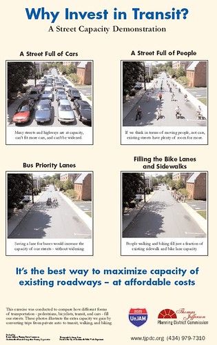
4. Built on a foundation of the achievement of optimal mobility. (Resources: David Engwicht--the father of transportation demand management and traffic calming, Jan Gehl, Arlington County Master Transportation Plan, Seattle Urban Mobility Policy)
Unjam 2025, Street Capacity Demonstration, Thomas Jefferson Planning District

5. Complete Street policies (Resources: Complete Streets, Context Sensitive Solutions, Smart Transportation Guidebook) + Multi-Modal Level of Service measurements

6. Focused primary on extant places rather than greenfield development*. The State of Maryland's system of designating "Priority Funding Areas":

The 1997 Priority Funding Areas Act capitalizes on the influence of State expenditures on economic growth and development. This legislation directs State spending to Priority Funding Areas. Priority Funding Areas are existing communities and places where local governments want State investment to support future growth.

is a good example of how to do this. (* Focusing on greenfield development is the biggest problem with the translation of the ideas of New Urbanism into practice.)

7. With the support of the development of plans that include specific plans and consensus priorities for neighborhoods and communities, with a coordination of public and private investment decisionmaking, including design review (Resources: Local Government Commission publications on community planning, Asset Based Community Development Institute, Temali's Community Economic Development Handbook)

Labels: , ,

Wednesday, March 17, 2010

Smart Growth: Maryland's Smart Growth Experience: Assessing the Impact

While it is "sold out" you can probably manage to sneak into this presentation tomorrow at the National Building Museum in Washington, DC. (I have a prior engagement.)
-------
Gerrit Knaap, director of The University of Maryland’s National Center for Smart Growth Research and Education, describes the challenge of making Maryland’s innovative smart growth policy a state-wide reality. Mr. Knaap offers insights into why the state's Priority Funding Areas, aimed to concentrate state investment in existing neighborhoods, did not deliver the results that state planners and smart growth advocates had hoped for. He also describes how other states or localities can learn from the Maryland experience and where Maryland goes from here to realize the promise of statewide smart growth.
------

I haven't read the paper yet. But it will be interesting to read. There are many many steps that need to be taken in terms of changing state and local policies in order to have on-the-ground impact with smart growth policies.

Plus, they take decades to see the results. Typical commercial district revitalization programs take from 10-20 years to begin to show results. It took as long as 30 years to see "smart growth-like" impacts from transit oriented development at certain WMATA transit stations, while some stations still haven't experienced significant positive change.

I wonder how carefully the paper elucidates the issues.

Working for a county government at the moment. I see a lot of difficulties, because so many groups:

1. Residents
2. Merchants
3. Government Agencies
4. Government Polices and Regulations
5. Developers and Investors
6. Financiers
7. elected County Councilmembers
8. the elected County Executive

have to be on the same page for anything to happen. Plus, "government agencies" aren't monolithic. Certain agencies may be supportive, others may not. And certain agencies (especially the budget office) have more suasion than others. All the operating agencies end up subservient to the County Executive in terms of policy.

Plus, you need money. And there has to be plenty of money to make it work. At least in a timely fashion.

In DC, TIF or "tax increment financing" based on anticipated future increases in tax revenues against which you can sell bonds to get upfront investment monies, is used all the time--maybe even too much. Plus there are so many property tax abatements (which also can be monetized) given out (without adequate evaluation) that the process deserves as much scrutiny as has been given recently to "earmarks."

In Maryland, apparently TIF has been used only about one dozen times across the entire state, according to this article, "Beechtree development touches off multimillion-dollar debate," from the Baltimore Sun about a proposed-TIF project in Harford County, a project that is getting heat from various sectors on ideological and other grounds. According to the article:

Though TIF has been in use for several decades across the country, Betnun said, it has only been used about 10 times in Maryland - to fund the public infrastructure for Arundel Mills mall, National Business Park near Fort Meade and National Harbor in Prince George's County, among other developments.

This makes it difficult to raise the necessary monies upfront to deal with issues in an accelerated fashion in "Priority Funding Areas."

It happens I've recommended TIF-based funding for a community plan-based project that I am tangentially involved in because parts of their community plan touch on the pedestrian and bicycle access planning process that I am managing. I'm not sure that there are even 3 other examples of the County ever doing such a thing.

(Plus, I recommend a TIF district or "transit value capture district" to be created to fund key transit extensions and route changes that I am hoping can get into the Master Plan. I have my fingers crossed. More, maybe, on that later, if it gets anywhere.)

Labels: , , , , ,

Saturday, November 28, 2009

Getting to smart growth relies on common sense, while staying with stupid growth thinking allows us to remain foolish

While I mentioned this letter to the editor, "Smart Growth needs common sense,"from the Gazette in a blog entry yesterday, I was thinking about it more this morning.

For the most part, "growth" or new development, is going to happen--so long as it is supported by existing zoning--whether or not people want it.

The challenge is to manage the process, and to work to mitigate the possibilities of problems.

Counties like Montgomery in Maryland have adequate public facilities ordinances which require that impacts on public infrastructure and facilities be measured and linked to approvals or disapprovals of development proposals.

Note that DC doesn't have adequate public facilities ordinances and for new projects, for the most part only the traffic impact is measured, no other impacts are considered, even though looking solely at traffic is a limited measure of the total impact of certain kinds of projects. (This is the heart of some of the arguments over intensification of land use along Wisconsin Avenue NW in Ward 3. Some smart growthers term opposition to this as nimbyism, but the reality is that there are legitimate infrastructure and capacity issues that must be addressed in various locations with regard to school capacity, water and sewerage lines, etc.)

So if development is going to happen anyway, which we can call "growth" or "stupid growth," shouldn't we try to shift as many of the trips that will happen anyway to transit, walking, and bicycling away from the automobile and the limited capacities of roads.

Focusing development in ways that optimizes the use of existing infrastructure and facilities of all types is what smart growth policies are about.

(To my boss, I mentioned an ungodly number, $500 million or more, for the cost to retrofit bicycling and walking infrastructure, including an off-trails network, in the County in which I am working in at present, and her retort was "think of how much it cost to build the street network" implying that providing basic walking and bicycling infrastructure should be considered just as basic as providing roads.)

The challenge of smart growth is that the people who challenge the policies as "lacking common sense" fail to see the lack of common sense in the policies that they espouse in their place. Doing what we are doing now is truly the foolish policy.

The reality is that they are advocating for stupid growth, or really for no growth at all, even though the U.S. continues to add population as does the region, and at some level a goodly amount of this new population must be accommodated and as many people point out in the comment thread, not everyone can be accommodated within the center city only (the position that people seem to think I espouse).

It is the stupid growth policy that is nonsensical and unsustainable.

Labels: , , , , ,

Wednesday, November 04, 2009

Elections

Just as when Bob Ehrlich, the Republican candidate, won the Governorship in Maryland in 2002 because he faced a weak Democratic candidate, I think the only thing that election results in Virginia ("GOP and McDonnell soar in Virginia" -- Post) and New Jersey ("Christie bests Corzine in election for N.J. governor" -- Post) from last night prove is that if you have weak candidates, it's a lot more likely you will lose. (See "Contests serve as warning to Democrats" from the Post.)

Because generally Democratic candidates favor transit and more rounded mobility programs (support of walking and biking, smart growth, etc.) this can be a problem. It certainly was in Maryland from 2003 to 2006.

That being said, Democrats are hardly perfect. But it is truly the case that it matters who wins elections.

The amendment to the Cincinnati charter that would have required a citizen vote on whether or not to build streetcars was defeated ("Voters reject city rail amendment" -- Cincinnati Enquirer), while citizens seem to have voted down a new land development in Davis, California ("Davis development defeated by 3-to-1 margin" -- Sacramento Bee).

And the Center for Transportation Excellence monitors elections on transportation-related issues around the country.

-- 2009 Election Monitoring & Results

Labels: , , , , ,

Tuesday, November 03, 2009

Remember the point about Montgomery County adjusting to a smart growth land paradigm

Check out this pro-automobile editorial from the Gazette from a couple weeks ago, " Where we grow from here." And this cartoon. (This is what I meant to blog about.)


From the editorial:

One of the main problems with the proposal is that some of the methods to encourage transit-oriented growth are overly burdensome. For example, the proposal calls for allowing development to take place when roads drop to a level of service barely above failing, if a high level of mass transit access is available. The goal seems to be to make drivers so uncomfortable that they will be forced off roads and onto buses and trains. Encouraging the use of mass transit is worthwhile, but this method is shortsighted — allowing roads to fall to such low levels of service would not help people who live outside areas that have mass transit, yet still have to drive through those locations.

Whatever. You can't build a mass transit mobility paradigm without focusing on mass transit. The reality is that a 40 foot bus takes the space of 3 cars to move 40-80 people. The focus has to be on optimality of the system, and preferencing 3 people over 40-80 is a no win equation.

You can do this in a place like Montgomery County, which has a decent (not great) heavy rail transit network. You can't do it in Anne Arundel County (where Annapolis is) which has a minimal bus service no significant heavy rail transit service--they possess a couple light rail stations and a couple railroad passenger stations but lack a fixed rail transit network--and most people drive--5.5% of people living in the county walk, bicycle or use transit to get to work.

But it is a challenge to change. 12 years isn't enough time--especially considering that with the interregnum of Bob Ehrlich as governor in Maryland that 4 years were excised out of smart growth planning, especially for transit--to change the paradigm.

Labels: , , , ,

Monday, November 02, 2009

Urban growth boundaries and success with "smart growth"

Of course, with regard to the report mentioned in today's Post, you have to have a variety of tools in place to make better land use decision making possible.

In Maryland, two counties, Baltimore and Montgomery, have relatively hard and fast "urban growth" boundaries, just like Portland, Oregon, even though in Maryland, they aren't called urban growth boundaries. (In Baltimore County, they do tinker with the line from time to time, I don't know about in Montgomery County.)

Baltimore County seems to be one of the first counties in the U.S. to create such a boundary, in 1967, called the Urban-Rural Demarcation Line. It was created because planners and officials were concerned about the cost of extending "city" water and sewer lines, as well as roads, into areas that were likely to be relatively less dense, so that the cost of the lines would have been considerable, not to mention the impact on the land.

I am guessing that Ian McHarg's early efforts at environmental planning in Maryland, including "Planning for the Valleys in Baltimore County" influenced the creation of this boundary.

Note that in Prince George's County, they have three broad categories shaping land use, including a rural tier that is supposed to remain relatively undeveloped, but unlike in Montgomery and Baltimore Counties, the rural tier is subject to far more in the way of political machinations.

See for example, "Prince George's County's Commitment to the Rural Legacy Program is spotlighted by rezoning of land east of US 301in the rural tier" from the Prince Georgian blog.

2. The second problem, even with having a rural area with less development as a solid and fast land use category, is getting residents to agree to an intensification of the land use within the developable areas, through the redevelopment of less developed parcels, and the possible significant increase in building heights, both in association with transit or within areas that are more highly developed.

This is very difficult, and is at the heart of the difficulties of smart growth planning everywhere, in cities and in counties.

3. I can understand why residents in areas of weak transit service (meaning no fixed rail transit service and/or lack of transportation demand management planning requirements) oppose land use intensification.

See, in places with good transit, 50% of more of trips from new development end up being captured by transit, not by cars. And this can increase.

But when you only have bus transit, for the most part, most of the new trips generated by the new development generate more car trips in significant numbers.

Transit and the expansion and development of quality "mass transit" is the key to successful land use intensification and smart growth.

But as you know, it takes decades to build or expand transit systems.

Labels: , , , ,

"Of course" "smart growth" in Maryland is a "flop"

According to today's Post, "Study says Md. law fails to direct growth, save open space."

From the article:

But a new study says the law has been a bust, largely because it has no teeth to force local governments to comply and because builders have little incentive to redevelop older urban neighborhoods. That's the conclusion of the study by University of Maryland scholars who lead the institute the former governor founded to promote the policy.

The reality is that 12 years is far too soon to judge the policy, although 12 years is just the right time to evaluate the gaps and problems seen in terms of trying to make such laws effective.

The reality is that to have smart growth policies work you have to change hundreds and hundreds of laws and processes at the local level--that means County by County.

And to do that, you have to have hundreds and hundreds of locally elected officials be in favor of the policy.

And to execute changes you need to have thousands and thousands of appointed officials (such as people in charge of the roads, planning, zoning, and schools) with congruent thinking--hundreds of officials in each County.

In my few weeks working for a county in Maryland, I have already found three significant barriers to smart growth planning that could be addressed by changes in laws and policies at the state level:

1. School systems aren't required to do balanced transportation and planning support walking and biking programs. (Plus state accreditation standards still probably--I haven't checked--support large school campuses as opposed to schools inserted into the urban fabric.)

2. The requirements on public universities for transportation demand management are minimal. And even though the universities are required to update their master land use plan every 6 years, they aren't required to have significant interaction with the local county for coordination purposes.

3. Most counties don't have bicycle parking requirements in their zoning code. (I was shocked to find out that the county I am working for lacks this... that's one thing that will go into the bicycle and pedestrian master plan I am working on.) State requirements for master land use plans--each county must update their plan every 10 years--could have much more significant requirements for transportation demand management elements within the transportation element.

(A 4th is the failure to require that local public facilities be located within transit station catchment areas if at all possible.)

... even Montgomery County elected and appointed officials can be a lot more resistant to "smart growth" than they come off. In fact, I have been meaning to write about this for a couple weeks.

The County Dept. of Transportation (last year it was split off from the DPW, which normally means that it is then able to be more "progressive") is still resistant to "boulevarding" Rockville Pike as a smart growth and quality of life strategy.

And County Executive Ike Leggett is opposed as well because he sees Rockville Pike's primary function as being the main route in and out of DC. While that may be true, from the standpoint of his county responsibilities, his job is to work on extending the quality of life and financial efficacy for the county, and that means compromises and focusing on doing things other than making roads wider and speeds faster...

Ironically, the Maryland State Highway Administration (who'd of thunk it right, but it does make a difference if a Democratic Administration is in power) thinks that boulevarding Rockville Pike could be a good idea.

Or, the Department's promotion of an underground road to better connect the Medical Center metro station to the expanded medical campus across the street, into which Walter Reed Hospital is moving, is an anti-pedestrian and anti-bicycling and somewhat anti-transit strategy, one that is designed to allow for expanded vehicle use.

There are many other examples. Meanwhile, Montgomery County has a pretty good land use plan and one of the most innovative "Growth" policies in the region.

If it is that difficult to institute smart growth policies in the State of Maryland's most progressive county, how hard do you think it is everywhere else in the state?

Especially in areas with "conservative" administrations, such as most of the rural counties.

2. The other problem is that politicians in the other party (regardless of who introduces the policy) attribute smart growth policies to the other party. Parris Glendening was a Democrat. So when Robert Ehrlich, a Republican, became Governor, he junked most every "Democratic" "Smart Growth" policy he could. It wasn't til it was time for reelection that he realized that some people cared about these issues regardless of the seemingly "Democratic" label he had originally given to the basket of policies (such as the Main Street commercial district revitalization program for small towns in the state, so he gave a bunch of money out, hoping to build support throughout these communities).

This happened in Massachusetts also. Republican Governor Mitt Romney, following Gov. Glendening's lead, created the Office of Commonwealth Development to coordinate land use, transportation, economic development and environmental policy in the State of Massachusetts. It was an unprecedented move.

They didn't force "smart growth" policies down the throats of the local jurisdictions, but they did change state grant programs to be congruent with smart growth policies, so that jurisdictions could only get money to do things if they were using relevant smart growth policies and principles for the projects.

But as soon as Deval Patrick, a Democrat, was elected Governor of Massachusetts, the Office of Commonwealth Development was abolished.

Changing land use and transportation planning policy takes decades.

For example, for at least 20 years after the creation of the WMATA subway system, economic analyses of the impact of the subway system on land use found no positive impact (through the mid to late 1990s), that's because it takes 20 years or more to start realizing changes.

And that was for an actual infrastructure improvement.

Getting policies changed in real and significant ways takes just as long.

That's why what Janette Sadik-Khan is doing in New York City is so exciting. Not to mention the progressivism of land use, transportation, facilities, and coordinated arts and culture planning in Arlington County, Virginia. It's all smart growth, even though they rarely use the term.

Labels: , , , , ,