Changing the land use development paradigm towards intensification: in the suburbs and in the center city
One of the reasons for the most part I am writing a lot less is that I am more interested in writing "integrative" posts synthesizing a bunch of grand points and ideas, because the day to day stuff tends to illustrate meta-ideas and frameworks that people often fail to perceive--and I have a lot less time because I do a brutal bike-railroad-walk-bus commute to and from work each day that takes hours. (And such posts take a couple hours to write.)
Anyway, I am working in a county in Maryland that definitely has a deconcentrated land use paradigm, despite many progressive land use policies, a place that is traditionally called "sprawl." Its road pattern is based on connections from Baltimore, and these days, when the center city is no longer as central a location for jobs and other activities, there isn't a satisfactory road network that moves people east-west and around the County, other than the Interstates.
In such an environment, promoting walking and bicycling is difficult for at least three reasons. First, the road network is focused on Baltimore and isn't the kind of grid road network that provides a plethora of alternate routes (it's an angled star of routes emanating for the most part from Baltimore), some of which could better accommodate bicycling than others. Second, the roads for the most part are narrow and/or traffic engorged, and it is difficult to find the space to add bicycle lanes. Third, because of the spread of distance between residential areas and amenities and activity centers, even though we can improve the environment for bicycling and walking in many places, the problem is that there aren't amenities present within a couple miles of people's homes.
See, the national research shows that 40% of household trips are 3 miles or less, and the idea in transportationally oriented walking and bicycling is to shift as many of these trips as possible away from the automobile. But if there aren't services and destinations present (other than civic assets such as schools, parks, libraries, and recreational centers) there is less reason to take up utilitarian-oriented walking and biking.
But in neighborhoods with the right spatial patterns and accessible amenities, even in what otherwise is termed suburban sprawl, people will walk and bicycle, and kids will even walk to school.
So the whole argument about intensification of land use practices (i.e. "Leggett taking more hands-on approach to growth policy" from the Gazette) in Montgomery County, Maryland is fascinating to me, both in terms of my learnings and understandings based on living in DC for a couple decades, witnessing both the decline and rise of the center city, and my having to deal with this as a planner in the Baltimore region (at least through the course of my project, which ends next July), in a county that is similar to Montgomery, but with an even greater dependence on the automobile, and less in the way of robust transit resources (Montgomery has a number of stations on the high capacity red line subway, which connects to four other lines, and one of the best suburban bus operations in the U.S., plus Metrobus services, even if their County Dept. of Transportation isn't as progressive as we think, "riding" on their two decade old decision to create RideOn ever since).
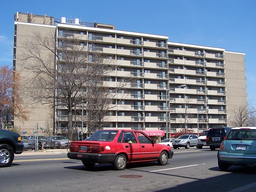
The Gazette this week is full of letters about how rebuilding the Safeway supermarket in Montgomery County's Wheaton community (last week's article which touched this off, "Planners hope Safeway would revive Wheaton"), a site which is a bit farther from the subway station than the Safeway on Georgia Avenue is from the Petworth station in DC (which I figure is destined for a similar kind of intensification), into a mixed use development with a supermarket on the ground floor (just like at CityVista at 5th and L Streets NW) and apartments-condominiums above, is a disaster of major proportions.

Safeway at 5th and L Streets NW. In October, I was riding by here early one Saturday morning on the way to catch a Chinatown bus to Philadelphia, and there was a guy walking on one of the streets, maybe 4th or 5th, on the other (north) side of New York Avenue, and even though the Avenue is a traffic engorged street, in the area around the Safeway it starts to get calmer. And I was thinking, how great would it be to live on one of these tree lined streets in a nice rowhouse, and be able to walk two blocks to the grocery (especially great now that Safeway has significantly decreased their prices on thousands of items--they used to be much higher priced than Giant), a hardware store, restaurants and other retail shops, and downtown. That adding amenities like this, albeit they come with additional residents, strengthens the city and strengthens neighborhoods, and makes it easier to get around without an automobile.
These are the letters:
- "Wheaton planners' approach myopic"
- "Smart Growth needs common sense"
- "Development running amok "
While I agree with one of the letter writers that having 400 parking places for a 500 unit building is too much, he sees this as leading to more congestion, I see it as way too much space for cars given the proximity to the subway station, and that the real myopia is to continue to plan primarily for automobility.
It makes me think about the various arguments I have to deal with in my own job, but also the difficulties we have in DC, trying to make the same kinds of decisions, not downtown, where intensification is accepted and is having incredible positive benefits, but at subway stations in other parts of the city that have been traditionally much less densely developed.
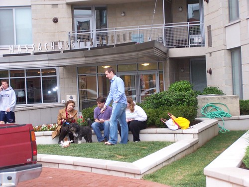
People on the street at 555 Massachusetts Ave. NW. These days people walk up and down Massachusetts Avenue, with dogs and/or children, when less than 10 years ago, it was desolate (true in part because it was being land banked for intensification), with few pedestrians other than those seeking nearby social services, homeless, and people seeking the services of transvestite prostitutes working on K Street NW. Now the area is becoming a desirable place to live.
As Denise Richards would say, "it's complicated."
1. Yes, these outer DC neighborhoods haven't been densely developed historically;
2. But density is a relative concept;
3. DC needs to leverage the location of high capacity transit in order to get return on investment for the billions of dollars spent on the subway system, to get more residents paying income, property, and sales taxes;
4. and to have more residents in neighborhoods supporting local commercial districts, providing eyes on the street, etc.;
5. because in this century, trends and attitudes favor urban living, rather than living in the suburbs and it is an opportunity that the center city can capitalize upon;
6. which is a decidedly different time from when the city was shrinking in population and businesses and the municipal government functioned even worse than it does now;
7. And it is reasonable to reconsider/consider surgical increases in density at subway stations specifically especially in other parts of the city despite overall neighborhood density and historical patterns to reflect this century and the city's needs of this century, rather than how things were being done from 1887 to 1920, as long as it can be done sensitively, in ways that strengthen neighborhoods rather than diminish neighborhoods.
This development is on top of the west side of Georgia Avenue exit for the Petworth Metro station, and had previously served as bus bays.
The developments at the Georgia Avenue subway station (Petworth), which are located in a more densely developed area (mostly rowhouses and apartment buildings) of the city, are demonstrating how multiunit buildings can be sensitively and attractively inserted in mid-density areas. And how this contributes to other improvements in the greater neighborhood.
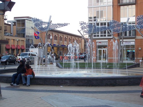
New neighborhood plaza in Columbia Heights, created as part of a public realm improvements plan associated with new development on 14th Street NW.
But neighborhoods like Brookland and the Fort Totten (Riggs Park, Michigan Park, and other neighborhoods) aren't as populated as neighborhoods in the core of the city, and 5 or 6 story buildings seem out of place in neighborhoods that are mostly two story attached and detached houses, even though such buildings, in areas of the city that have a more variegated building typology (mix of commercial, apartments, medium sized buildings, rowhouses, etc.) are not unusual.
So redevelopment projects targeting Brookland, specifically on deaccessioned land from Catholic University along Monroe Street (see "Brookland and Abdo Getting Closer to New Development" from DC MUD) and eventually at the Brookland subway station, and with the redevelopment of low density garden apartments adjacent to the Fort Totten Metro station are more controversial ("Mixed-use projects in District advance: Retail, housing centers on deck for Fort Totten, Brookland in NE" "An uptown vision for a '50s neighborhood: Foundation plans new housing, retail and arts space near Fort Totten, but tenants are anxious," and the editorial saying don't be scared, "A future for Fort Totten: Shops and housing for a D.C. neighborhood" from the Post).
The reality is that while yes, more traffic is generated when you add population, but it's going to happen anyway but with a robust transit network as is present in DC, as much as 50% of the trips made by people who live within a short distance of the subway system are made via transit, reducing car usage significantly. And with more transit users, adding more transit service becomes possible, further reducing automobile trips.
I see the results of these changes as a regular bicycle rider on the city's streets.
While I don't record my observations on a day to day basis, there is no question that on many of the city's major streets, traffic is less than it was, even though the city's population is increasing. Sure, these days, the recession is impacting traffic. But I have been noticing this for years. Even in dense areas of the city, during rush hour periods, I can ride my bicycle through red lights because of the lack of oncoming traffic. (I am a fervent proponent of the Idaho stop...)
But most people don't seem to see this real and fundamental change, so on a different scale, DC has the same kinds of issues that they have in Montgomery County in terms of changing the land utilization paradigm, and we haven't been very good about educating people, even though the DC Office of Planning has at least one excellent publication that explains many of the issues, Trans-Formation: Recreating Transit-Oriented Neighborhood Centers in Washington, DC.
DC did do station area plans (in the 1970s) in advance of the subway. And in some parts of the city, citizens fought off plans for intensification. The funny thing is that I am glad they did it--then and only then--because the prevailing design sensibility and perceived value of the city was focused around the urban renewal ideal, so new buildings at subway stations would have looked like this (see below) and that wouldn't have strengthened the city or the neighborhoods. Instead it would have created a new kind of blight that would need to be redeveloped now, just as the Waterside Mall and other areas of southwest DC are being redeveloped today--and that area was one of the national pilots for urban renewal planning in general.
Delta Towers on Florida Avenue NE in the H Street neighborhood is a senior housing apartment building constructed as a result of the post-riot H Street Urban Renewal Plan. Imagine this in Columbia Heights or Petworth or Takoma.
But now, it's possible--if you demand it, and the jury is out--to get quality design. It's not a regular occurrence, but it does happen. Fort Totten is pretty bad thus far. But the new developments by the Columbia Heights and Petworth stations are pretty good. The developments by the Takoma Metro are about 1/3 each very good, good-acceptable, and abominable.
It is very much dependent on the quality concerns of the developers. Quality design does pay, reaping higher returns, especially in DC, but even in DC the payback period is longer, and developers more focused on the quick return and flipping aren't concerned about the higher paybacks because their business model means that they won't own the property when it starts gushing profit.
This is why developers like Abdo Development, Chris Donatelli, PN Hoffman etc. are to be preferred over most of the others. For the most part, they care about design quality. Too many other developers do not.
I hope that with quality projects, more people will see the value of quality development, and more people will come to understand the link between intensification of land use and the availability of walkable-bikeable-transit accessible amenities within neighborhoods across the city, and accessible by residents from many neighborhoods. (In any case, most DC neighborhoods lack the population density to support complete commercial districts within their neighborhoods as a minimum of 20,000 people is required to support a local commercial district, and 30,000 people are required to support a high quality supermarket and related stores.)
And hopefully they will see how "better" development leveraging access to high quality transit reduces road congestion overall.
And that elected officials, rather than caving in to most demands from developers, will demand excellence instead of mediocrity, and take care to steward the future of the city for generations, not just worry about today's seeming crisis and request from a developer focused on an even shorter time frame than elected officials (4 year terms for elected officials...).
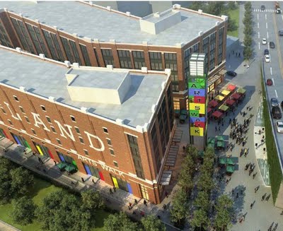
Rendering, loft style "Arts Walk" building, proposed Brookland-Catholic University development by the Abdo Development Company.
Labels: civic engagement, intensification of land use, land use planning, sustainable land use and resource planning, transportation planning, urban design/placemaking, urban renewal, urban revitalization
posted by Richard Layman @ 9:54 AM&Permanent Link
![]()
![]()


0 Comments:
Post a Comment
<< Home