Interesting planning initiatives/research in Toronto
 1. The City of Toronto, like Montreal and other cities, has an extensive underground tunnel-connections network, linking building basements and sub-basements to the subway system.
 According to users, there are wayfinding issues, because the system doesn't conform to the street grid above.
- PATH facts (e.g., serves 100,000 commuters/day, etc.)
- The display panels from the first the Drop-In event held in May 2011 sets the stage for the study.
The PATH network has some of the same kinds of issues related to what I call "edgespace" and opportunities for an arcade at the New York Avenue Metro Station mentioned in past blog entries, "NoMA revisited: business planning to develop community," and "Transit and Placemaking."
2. The Avenues and Mid-Rise Development Study by the Toronto City Planning Division won an award from the Ontario Professional Planners Institute. See "Mid-rise, everything you want in a condo — and less" from the Toronto Star.
Interestingly, the buildings that they highlight as best practice seem to typify the types of condo and apartment developments prevalent in DC. This makes sense because high rise development in DC is mid-rise anywhere else (except Portland, Oregon, which has similar building height limits).
Thinking about this study and the issues in DC, I don't think that there is consensus within the city about adding density in commercial districts (avenues in the parlance of the Toronto study) to accommodate opportunities for growth.
I think the biggest failure of the Comp Plan revision process (2004-2006) was not following up the approval of the plan with a public outreach process, to explain the intent, and build a consensus for the kinds of development, transportation, and other proscriptions outlined in the plan.
- cf. How Does the City Grow from Toronto City Planning Division
3. The Canadian Heart and Stroke Foundation has a toolkit, Shaping Active, Healthy Communities, workshop guide, and other resources for people interested in improving their health by improving the physical conditions of their communities.
4. However, researchers at Queens University have found that while urban environments have better spatial conditions for walking and biking, when it comes to active lifestyles for children, suburban environments may be better because reduced traffic means that kids can play in the street, and there are more likely to be parks and other open spaces nearby in suburban environments. See "Where do kids get more exercise – the suburbs or the city?" from the Toronto Star.
From the article:
Studies have shown that areas ... with well-connected streets and a high density of intersections, promote exercise among adults, who are more likely to walk or cycle to work or the green grocer.
But a recent study by Janssen and other Queen’s researchers suggests high street connectivity has the opposite effect on children. That’s because dense, busy neighbourhoods aren’t as conducive to unsupervised play or kids roaming up and down sidewalks on rollerblades or scooters.
“Where houses are crammed, yards are small and there’s more traffic, there may be no place for kids to play,” says Janssen. “Whereas if you have a quiet cul-de-sac it becomes a playground.” Those zones can become hotbeds for road hockey, dodgeball and skipping ropes.
The report, published in the International Journal of Environmental Research and Public Health, used data from a 2006 survey of school-aged children from grades 6 through 10 (ages 11 to 15). It looked at the physical activity patterns of 8,535 students from 180 schools across Canada, and then compared it to the 5-kilometre area surrounding each school.
The study found that youth in the neighbourhoods of highest density and most connectivity between streets were less likely to be physically active outside school.
Many factors determine how much exercise children get, including access to organized sports, whether parents can afford them and family attitudes regarding fitness. However, the Queen’s research was noteworthy because it demonstrated how street connectivity appears to have opposite effects on adults and kids.
All the more reason to tighten up "Level of Service" guidelines for parks, open space, and recreational spaces and opportunities in urban settings.
-- How Do You Effectively Assess a Community’s Need for Parks and Open Space? from Recreation to Re-Creation: New Directions in Parks and Open Space System Planning, and Providing Equity for Parks and Recreation Facilities, from Florida Recreation and Parks Journal, both by David Barth, ASLA, AICP, CPRP.
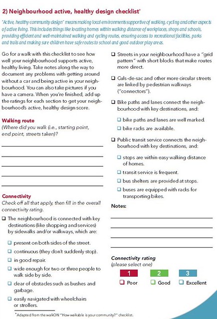
5. The Toronto Star article mentioned in the previous section prints an abbreviated list from the Heart and Stroke Foundation's Neighbourhood active, healthy design checklist (also in the Shaping Active, Healthy Communities toolkit) for rating neighborhoods in terms of their community design and whether or not the spatial organization of the community encourages physical activity:
Rate your neighborhood
• Are homes connected to stores and services by sidewalks and/or walkways?
• Are there sidewalks on both sides of the street? Are they continuous, in good repair, and wide enough for strollers or more than one person?
• Do streets form a grid pattern with short blocks that make routes more direct?
• Are culs-de-sac and circular streets linked by walkways?
• Are there bike paths and lanes to key destinations?
• Are public transit stops in easy walking distance? Is service frequent? Are there bus shelters?
• Are homes in walking distance of stores, services, schools, parks, recreational facilities and workplaces?
• Is there a mix of residential, business, stores and schools?
• Is there a mix of housing such as apartments, townhomes, single family dwellings?
• Are walking routes attractive and well maintained?
• Are routes not broken up by too many vacant spaces like parking lots or empty buildings?
• Are there benches or other resting places along the way?
6. Mississauga had their annual Big Ideas Summit, see "Mississauga Summit showcases five big ideas" from the Toronto Star. From the article:
The Mississauga Summit, scheduled for Tuesday night, is the fourth in an ongoing series that began in 2007 and is modelled after Greater Toronto’s CivicAction — a way to engage residents by having them contribute their own plans.
The event, held at the University of Toronto Mississauga, with an appearance by Calgary Mayor Naheed Nenshi, was to feature five “big ideas” whittled down from an original 18. The five are: waterfront, diversity, human services (health and social services), post-secondary education and jobs.
The point, said co-chair Shelley White, is to let the people decide what’s next for the growing and diverse community. Over the past two years, summit organizers struck up five task forces comprised of businesses, non-profits, government and citizens who volunteered their time to draw up a vision for Mississauga’s future. “Government can’t be expected to do it all,” said White, president and CEO of United Way Peel Region.
7. The MaRS Centre (Medical and Related Sciences) in Toronto's Discovery District is focused on developing science and technology businesses and entrepreneurship development. They've had 1,200 clients since 2006.
Labels: urban design/placemaking
posted by Richard Layman @ 8:00 PM&Permanent Link
![]()
![]()


0 Comments:
Post a Comment
<< Home