DC Height Study Public Meetings This Week and the long term implications for transit expansion in DC
1. This is a meeting announcement from the National Capital Planning Commission:
This week NCPC and the District Office of Planning host the last two public meetings as part of the initial phase of the Height Master Plan for Washington, DC. At the meetings, you will hear about the core principles shaping the plan and case studies from peer cities. You can share your ideas about how the Height of Buildings Act affects federal and local interests. Each meeting follows the same format and agenda. #HeightDC
MEETING #3: Tuesday, June 4, 2013 | 6:30 - 8:30 PM
National Capital Planning Commission
401 9th Street, NW Suite 500N
MEETING #4: Thursday, June 6, 2013 | 6:30 - 8:30 PM
Savoy Elementary School
2400 Shannon Place, SE
| See what's already been said (PDF) | |
| Learn more about the study | |
2. My response with regard to the linkage between allowing for taller buildings and funding transit expansion, specifically creating the separated blue line subway in DC.
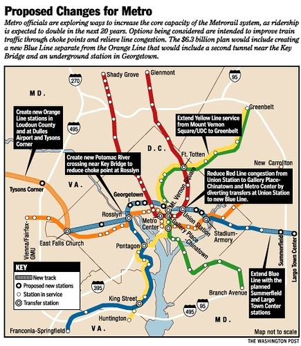
2002 Plan for the creation of a separated blue line subway. Washington Post graphic.
In May, I had some interesting conversations about the Metro Momentum long range vision for transit expansion planning with some people in and out of DC government, people who really know transportation and the inner workings of DC government.
The point he made is how DC is totally screwed in the context of metropolitan transportation planning, because to get all the jurisdictions to buy into the plan, the major focus is on extension of the subway system outward, further into the hinterlands of the region, which furthers the polycentric nature of the system, into those areas where heavy rail transit is far less effective at providing transit service over long distances. That far out should be served by true railroad service as it relates to the core of the region.

WMATA polycentric rail system -- diagram from Belmont, Cities in Full.
This confirms my point about how metropolitan and regional scale transportation planning ought to be done. See "Metropolitan Mass Transit Planning presentation" and "Reprint (with editing): The Meta-Regional Transit Network."
It should be done by the area's Metropolitan Planning Organization (theoretically), not the transit operator, and it should study all potential modes, not the particular mode of the primary operator.
Although some places, Portland and Minneapolis in particular, and Utah to some extent, the metropolitan and regional planning organizations do integrated transportation planning and also control the transit system. In those places, it's completely different than in Metropolitan DC.
Plus, as the Center for Transportation Studies at the University of Minnesota makes the point, the greatest economic return from transit lines and networks comes from the core of the system, not from further out. See: Understanding the Impacts of Transitways The Hiawatha Line: Impacts on Land Use and Residential Housing Value, research brief, full document.
That being said, the Metro Momentum plan does call for expansion in the core of the city, with proposals, too truncated for me, for some separation of the blue and yellow lines. (More on the yellow line separation in another blog entry.)
This leads into the second conversation. That person suggests that the economic justification for the separated blue line is not there because for the most part, at current density and height limits most all of the catchment area of the proposed blue line alignment from 2002 is already built out. (I forgot but I have made the same point in the past, see "More discussion of the height limit #2: Without adding high capacity transit service, there should be no increase in allowable heights.")
Sure, you need to add redundancy to the system (my point, which he agreed with)--but otherwise, it would be awfully expensive for limited economic return.
 Left: technically, the front yard of the 10-story former Adventist office building in Takoma Park, Maryland is located within DC and fronts Eastern Avenue.
One of the only ways to pay for a separated blue line serving Downtown DC and beyond including Union Station, would be from property value increases that come from expanding the height limit for buildings Downtown.
Not to mention that the idea that people will be attracted to tall buildings in non-central locations is for the most part, misguided. People want to be in the places that matter. This is the basis of urban economics and the concept of agglomeration economies.
And it is the desire to be in central places that makes the land more valuable and therefore it becomes financially efficacious to build taller and denser, which is much more expensive than building sprawled out un-dense buildings in distant locations. From Creating a Vibrant City Center published by ULI:
Concentration and Intensity of Use: "The intensity of development in the traditional central area was relatively high due to the value of the land. Maximizing site coverage meant building close to the street, which created a strong sense of spatial enclosure. Although city center development was dense, construction practices limited building height and preserved a human scale. The consistency in building height and massing reinforced the pedestrian scale of streets, as well as the city center's architectural harmony and visual coherence." (p. 11)
Organizing Structure: "A grid street system, involving the simplest approach to surveying, subdividing, and selling land, created a well-defined, organized, and understandable spatial structure for the cities' architecture and overall development. Because the street provided the main access to the consumer market, competition for street frontage was keen. Development parcels were normally much deeper than they were wide, creating a pattern of relatively narrow building fronts that provided variety and articulation in each block and continuous activity on the street." (p. 12)
Mostly, tall buildings in outlying locations within the city end up being one-off productions, usually the result of very particular circumstances within particular organizations that could be called "boosterism" but more locally driven outside of the central business district.
Urbanophile has a nice entry which covers boosterism. See "Inevitability of Community in Small Cities." Also relevant is the discussion of investment in urban neighborhoods by locally owned banks from Death and Life of Great American Cities.
Examples that come to mind are the 10 story office building in Takoma Park, Maryland--literally feet from the DC border--which was built by the Seventh Day Adventist Church, which needed the space, when their eastern headquarters was located there.

But these are one-off projects. There weren't other clustering benefits that would have led to other organizations to invest there, by constructing other tall buildings, and creating another center.
Subway expansion in the core is yet another reason to support the consideration of height increases for buildings in the Central Business District. The other reason being that height limits and the strong demand for space in the Downtown leads to the displacement of all uses except for those capable of paying the highest rents. See "Height Act: It's important to discuss but too late to make any difference on what has already happened."

Note that height increases shouldn't be granted as "matter of right." They should be tied to the receipt of benefits and mitigation, especially if taller buildings will come with some negative impacts. See "More discussion of the height limit #1: Grant height increases conditionally, in return for significant public benefits, not as matter of right."
Also, to reduce the negative impact from particularly tall buildings, there should be a lot size limitation for tall building projects in the Downtown.
That's the way to militate against the current problem not of "superblocks," because for the most part DC's blocks are small, but what I think of as "superbuildings" or buildings that take up most of a block, with limited entrances and therefore have a dampening impact on street vitality.
Labels: building a local economy, cultural landscape, historic preservation, public finance and spending, real estate development, transit and economic development, transportation planning, urban design/placemaking
posted by Richard Layman @ 1:10 AM&Permanent Link
![]()
![]()


2 Comments:
all of the colored metro lines should be separated once they enter the city proper in DC. I agree- we need a different heavy rail system to accomodate suburban needs and keep the subway system as serving primarily the core. The suburban interests are watering down the effectiveness of metro and it will become more difficult to maintain over the decades as it sprawls outward. Again- my idea of an expanded city border could help in a planning setup for this- but likely it would never be allowed to happen here. DC's city limits need to go out to the beltway.
Thanks nice providing information.
Post a Comment
<< Home