First global benchmark for road safety in cities published by International Transport Forum
I've written from time to time on Vision Zero initiatives:
-- "A 'Vision Zero' Agenda for DC," 2014
-- "DC and Vision Zero Revisited," 2015
-- "Updating Vision Zero approaches," 2016
-- "A reminder about how the entitlement of automobility is embedded into law and democratizes death by accident," 2014
For the most part, DC's traffic-related deaths are about 30 people per year, half car-on-car and the other half involving pedestrians and cyclists ("Traffic deaths continue to soar despite cities pledges to get them to zero," Washington Post).
Because the number doesn't vary that much from year to year and "seems low" compared to other places, I've had a hard time figuring out whether or not DC is performing better or worse, and whether or not implementing all the various detailed recommendations I've come up with in the past would make much difference.
The International Transport Forum is a program of the OECD, and Safer City Streets is an initiative of the ITF. SCS has just released a report benchmarking 31 cities ranging from Stockholm to Bogota. In North America, Montreal and New York City are included.
They used the measure "deaths per 100,000 residents." Stockholm had the fewest deaths on that score, 0.9 per 100,000, while Montreal had 1.8.
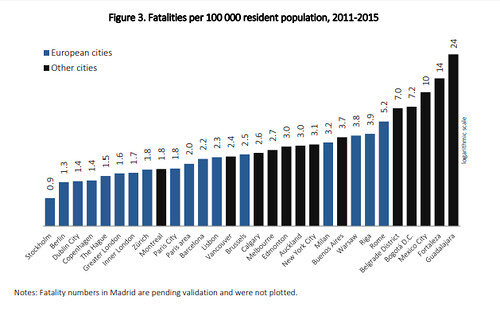
But with 700,000 residents, that means that DC's fatality rate is 4.28, almost five times higher than Stockholm, which has a population about 25% larger than DC, or 952,000 residents. The study recognizes that better measures, including daytime population numbers--nonresident workers and visitors--are necessary to get a better handle on what the data means.
DC has a high daytime population, but so do most of the other comparison cities. So now I see, comparatively speaking, DC's road-related fatality rate is pretty high.
The study finds that in cities, walking and cycling death rates are lower compared to countries as a whole, and within metropolitan areas, center cities are safer for vulnerable road users. Interestingly, the risk to men is about double that of women. Younger and older age cohorts are more vulnerable as well.
The report, Safer City Streets: Global Benchmarking for Urban Road Safety, makes some important recommendations, that cities should:
- create mobility observatories, to collect and report on a wide range of urban mobility and road safety data including on behaviors, attitudes and enforcement;
- collect traffic casualty data from hospitals, not only from police records, to obtain more accurate data;
- adopt ambitious targets to reduce the number of road casualties in cities;
- focus on protecting vulnerable road users;
- use appropriate indicators to measure the safety of vulnerable road users in cities;
- estimate daytime population to improve the comparability of traffic safety statistics (this would includes nonresident workers and visitors)
- prioritize research on urban road crashes.
I like the idea of creating "mobility observatories."
WRT DC, I've complained that the city's transportation dashboard doesn't provide data that is easy to interpret or actionable because it is gross-grained, with minimal detail.
For example, this article about pedestrian deaths in , details deaths by time of day and day of the week, etc.,
One advantage of "mobility observatories," which could be set up within city transportation or planning departments, is that by producing a standardized report and organized according to land use context, making the data comparable across jurisdictions.
Through benchmarking across jurisdictions--cities of different land use types, counties, etc.--jurisdictions could then get a better handle on directions and actions to take to achieve meaningful reductions.
Such data should be provided at the metropolitan state, and national scale, including a side by side listing of the nation's larger cities.
For example, San Francisco's population is not quite 900,000 and last year the city had 20 traffic-related deaths, although that was an anomalous 50% decrease compared to the general average of about 30 per year ("SF traffic fatalities in 2017 lowest in city's history," San Francisco Chronicle). Using the per 100,000 residents calculation, their rate for 2017 was 2.2, more than double that of Stockholm.
Boston had a similar number of deaths, 22, and almost two-thirds were pedestrians ("Fatal Pedestrian Crashes Up In Boston, According To City Report," WBUR/NPR), and the city has a population just under 700,000, so their rate was 3.14 deaths per 100,000 population, definitely lower compared to DC.
Etc.
=====
This Idaho Statesman article was interesting to me, "6 pedestrians hit, killed in Ada County in 2018. Would lower speeds, lights save lives?," because of how it differentiated data by time of day and other criteria, and seems a much more useful presentation that makes it possible to take real steps for change. From the article:
With a month and half left in 2018, the county has already had six pedestrian deaths. That ties the highest number of annual deaths in the past two decades, according to data from the Idaho Transportation Department. Canyon County has had one.
Last year, there were five pedestrian deaths in Ada County — and the number of people suffering incapacitating injuries doubled over the previous year from 20 to 43. That’s an injury that prevents a person from walking, driving and doing other normal activities. ...
Here’s what a review of ITD crash reports, police information and crash scenes showed:
- Three of the fatal crashes were in Boise, the others were in Garden City, Eagle and Meridian.
- Three occurred during the day, three at night. Poor lighting was a factor in the night crashes.
- Three of the pedestrians are believed to have been jaywalking when hit, one was standing next to a broken down car in the dark, one was laying in the road while doing mechanical work and one was in a crosswalk.
- One driver tested positive for alcohol but was well below the legal limit for driving. Two pedestrians tested positive for illicit drugs. That information is not yet available on the two most recent crashes.
- Four of the pedestrians killed were men, two were women. They ranged in age from 20 to 83.
- Four of the drivers were women, two were men. They ranged in age from 20 to 76.
“The one common denominator through most of them would be attention or lack of attention — whether that would be on the pedestrian’s part or driver’s part,” said Boise Police Detective Chad Wigington, who is part of the department’s crash reconstruction team
Separately, some newspapers, like the Toronto Star, have been running campaigns focused on vulnerable road users ("2017 another terrible year for road safety").
The Toronto Police Department provides a reasonably good traffic fatality dashboard. They just need to add time of day... It states that there were 62 deaths last year, so that makes the rate per 100,000 population 2.2, seemingly not terrible. But their pedestrian rate of death only would be 1.5 per 100,000 residents, which is high.
Labels: car culture and automobility, public safety, public space management, traffic engineering, traffic safety and enforcement, transportation planning, urban design/placemaking
posted by Richard Layman @ 3:33 PM&Permanent Link
![]()
![]()


0 Comments:
Post a Comment
<< Home