Rebuilding Place in the Urban Space

"A community’s physical form, rather than its land uses, is its most intrinsic and enduring characteristic." [Katz, EPA] This blog focuses on place and placemaking and all that makes it work--historic preservation, urban design, transportation, asset-based community development, arts & cultural development, commercial district revitalization, tourism & destination development, and quality of life advocacy--along with doses of civic engagement and good governance watchdogging.

Wednesday, August 05, 2026

"If you build it they will come" | Pedestrians and bicyclists and the Gordie Howe International Bridge

I mentioned this bridge in a blog entry about Trump ("Fourth of July | US 250th anniversary of the Declaration of Independence").  

The Windsor Ontario-Detroit Michigan crossing is the #1 place for goods movement between the countries.  

The Howe Bridge was built to provide better connections in the face of access and environmental issues with crossings at the privately owned Ambassador Bridge and that the Detroit-Windsor Tunnel is not big enough to accommodate the size of today's trucks, let alone the volume of traffic

Of course, Trump f* it all up.  Canada ended up paying for the entire cost, and will give a portion of toll revenues to Michigan.

But one of the most interest points from the standpoint of bicycle and pedestrian mode planning, is that the Bridge, even though it will require going through Customs/Border Patrol on both sides, because it is an international bridge, planned for bicycle and pedestrian access.

Pedestrians on the Gordie Howe International Bridge.  

And bicyclists

Even a wheelchair user

A lot of intra-nation/intra-state bridge planning ignores this.  This came up when I worked as a bike planner for Baltimore County Maryland.  While there are a number of bridges in the DC area like 14th Street from DC to Virginia and Wilson Bridge from Maryland to Virginia, many bridges in the Baltimore area don't have this kind of accommodation.

Under anti-sustainable mobility governor Hogan, Maryland deliberately didn't include bike and pedestrian accommodations on the Nice Bridge, which crosses the Potomac River, connecting Maryland (Charles County) and Virginia (King George County) via US 301, a bypass route, in the exurban part of the DC region ("No Bike Path for New Nice/Middleton Bridge," Maryland Matters).

There is another bridge crossing barrier on I-95, the Millard E. Tydings Memorial Bridge carries Interstate 95 over the Susquehanna River between Havre de Grace and Perryville, Maryland. (It's also an issue between Philadelphia and New Jersey.)

While it's said that a bike crossing isn't allowed because it's an Interstate freeway, technically that isn't true.  Maryland could put a bike path there because ultimately these decisions are made at the state level.

Conclusion.  Generally I don't believe in "build it and they will come."  Instead I believe in "build it in the right place and setting it up for success and they will come," Canada illustrates the latter.  The right infrasstructure in the right place will be successful.  And it's better to add to access and connections rather than to subtract it.

Kudos to Canada!  ("Crowds line up to walk and bike across new Gordie Howe bridge," Detroit Free Press)

Ana Guajardo crossing into the USat Laredo, Texas on a 1,555 mile journey from Monterrey, Nuevo Leon to Chicago, Illinois ("Cyclist with a cause passes through Laredo on 1,555-mile journey," Laredo Morning Times).

Pedestrians and bicyclists can cross on at least some of the bridges from Laredo or El Paso to Mexico.

And there is a special international crossing, for pedestrians, only, the Cross Border Xpress, from California to the Airport in Tijuana.  

And three international bridges in New York offer the same amenity, according to the DFP.

Labels: , , , ,

Wednesday, January 10, 2018

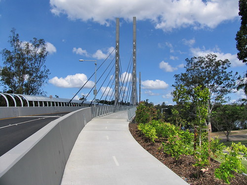
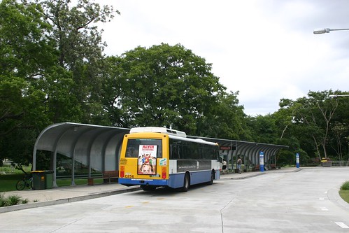
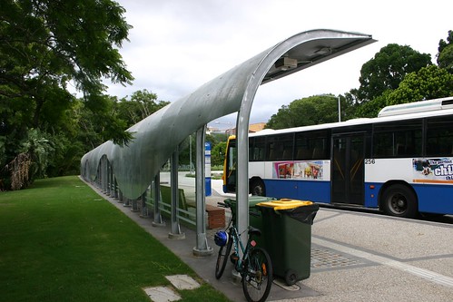
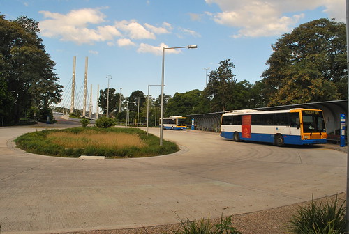
Another green bridge: Eleanor Schonell Bus Bridge, Brisbane

In response to the previous post proposing that the Long Bridge expansion project be conceptualized as a DC area "Green Bridge" devoted to sustainable modes, our NZ e-correspondent Nigel calls our attention to the Eleanor Schonell Bus Bridge in Brisbane, Australia, which is a "green bridge" serving bus traffic, pedestrians and cyclists ("At last, a public transport bridge," Brisbane Institute).  

This Schonell Bridge opened about a decade earlier than the Portland bridge, although it's shorter and doesn't support as many modes as Tilikum Crossing.

In terms of constrained vision and/or design, Nigel points out that the bridge access is truncated on the University of Queensland St. Lucia side of the bridge, where there is a cul-de-sac, so that buses turn around and return to the Eastern Busway.  Cross-bus traffic via the bridge, connecting to other parts of the transit network, is not possible.

This is not atypical.  In the US, some universities have been known for their opposition to adjacent transit lines (the case at some point for University of Southern California, University of Maryland College Park, and Virginia State University in Norfolk, Virginia).

The University of Queensland mandated the cul-de-sac so that there wouldn't be a bus way across the campus ("UQ Senate sets out conditions for the construction of BCC green bridge," UQ News), connecting to the town of St. Lucia or to the eastern busway.

The bridge replaced a ferry system and provides greater capacity. Because of demand more frequent service and new bus lines have been added to serve the campus. Taxis are forbidden from using the bridge, based on the agreement with the university.

Interestingly, USC, UMD-CP, and VSU now favor rail transit.  And so does the University of Queensland, because of their experience with how the green bridge changed mobility practices for their campus.

According to the Brisbane Times ("Council anger as UQ plans new bridge to west end") since the "green bridge" was opened and with various improvements to transit service for the campus, now a majority of trips to and from the campus are made sustainably.  The university aims to service growth in enrollments and activity through even greater transit connectivity.

The new campus master plan aims to build on this change by (1) building a tunnel to connect the UQ Lakes bus station at the Green Bridge to the cross-campus UQ Chancellor's Place Bus Station and (2) adding a second bridge crossing, with it having the capacity for rail transit as well.

The underground tunnel makes the link between the green bridge and the west side of the campus, which had been forbidden by the original agreement. 

The underground connection satisfies concerns about the conflicts that likely would develop on the surface between pedestrians and vehicles and the sheer number of buses likely to travel across the campus.

Sometimes, it takes the experience of transit working to build the demand and support for more transit.  Although this is a more expensive and much longer way to bring it about.

eleanor schonell bridge (4)

Eleanor Schonell Bridge, also known as the Green Bridge, Brisbane

Busstop at Eleanor Schonell Bridge, also known as the Green Bridge, Brisbane

Bus Stop & Green Bridge Columns

Labels: , , , , , ,

Tilikum Crossing Bridge as a model for the DC-Virginia Long Bridge Expansion Project

I have been remiss in submitting comments to the Long Bridge Project, where I intended to suggest that the bridge, mostly conceptualized as a railroad expansion project going from two to four tracks to better serve railroad passenger service, should also have a dedicated busway, to provide an exclusive routing for buses crossing the Potomac River as well as providing redundancy and another connection to DC from National Airport.
A Public Information Meeting was held on December 14, 2017 to present the proposed alternatives to be evaluated in the Draft EIS. The meeting materials can be viewed here. Comments can be submitted until Tuesday January 16th, 2018, to info@longbridgeproject.com 
The bridge is owned by CSX Transportation, a freight railroad, and is adjacent to a separate bridge for Metrorail.

CSX prioritizes freight transportation, and passenger rail use is secondary.  Expansion to accommodate passenger rail will have to be borne by the public.  Virginia's desires to expand railroad service south and to expand VRE passenger service are held hostage to the two tracks.

For example, because there aren't enough "slots" available during peak service hours, for the most part, VRE trains make only one trip each way in the morning and night, so that they are forced to buy and operate more equipment than if trains could make round trips. This also stresses storage capacity within DC.

As part of Virginia's Atlantic Gateway project, they have prioritized the expansion of the Long Bridge, and in an MOU with DC, are taking the lead in making the expansion happen.

Today, the Washington Area Bicyclist Association sent out an advocacy email ("A better bike bridge over the Potomac and two highways"), making the point that the Long Bridge expansion should or could include an exclusive bikeway, but this is not a priority in the recommendations. From WABA:
  • Make the Long Bridge bicycle and pedestrian connection continue across the George Washington Parkway to connect to the Long Bridge Park (Arlington County’s Long Bridge Park Master Plan has long called for a connection from the park’s multi-use esplanade across the George Washington Parkway to the Mount Vernon Trail)
  • Make the Long Bridge bicycle and pedestrian connection connect directly to Maine Avenue, instead of requiring an indirect, congested or outdated connection across the Washington Channel
  • Leave space for a future trail connection across Maine Ave to Maryland Ave and Hancock Park, and
  • Build the bicycle and pedestrian infrastructure simultaneously with the rail span, not as a separate project.
In association with my busway thinking, and passenger rail + bus + bike + the adjacent Metrorail bridge, I am reminded of the Tilikum Crossing Bridge in Portland, Oregon, which is devoted exclusively to sustainable modes-- --and includes no regular crossing capacity for motor vehicles, excepting emergency vehicles ("Tilikum Crossing in Portland Won't Allow Cars," The Atlantic).

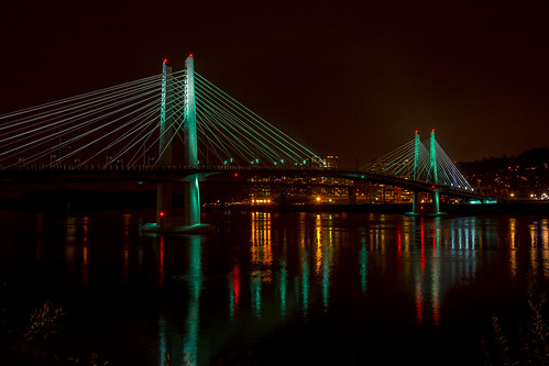
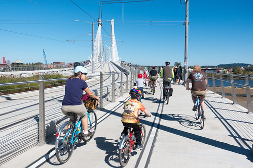
The Tilikum Crossing Bridge supports the local light rail, the Orange Line MAX, streetcar, buses, pedestrians and bicyclists, and emergency vehicles.  It also has been designed to incorporate special architectural lighting.

Tilikum Crossing and Mt Saint Helens • December 31st, 2015
This photo shows a light rail train, a streetcar and buses using the bridge at the same time.

Tilikum Crossing aesthetic light testing

back over the other side
Bicyclists using the bikeway section of the Tilikum Crossing Bridge.

Why not reconceptualize the Long Bridge project similarly? and include elements that support bus transit and biking and walking.

To highlight the city's focus on sustainable mobility, DC needs an exclusively sustainable mobility bridge, which is in keeping with the priorities of the MoveDC transportation master plan and the Sustainability Plan, which aims to achieve 75% of work trips by sustainable means.

The expansion of the bridge for passenger rail also enables my recommendation to merge the MARC Penn Line and the VRE Fredericksburg Line as a step towards creating a regional railroad passenger service I call RACER ("A new backbone for the regional transit system: merging the MARC Penn and VRE Fredericksburg Lines").

Labels: , , , , , ,

Thursday, October 23, 2014

Speaking of bridges

As has been reported in the media, the team of OMA and Olin has been selected for DC's 11th Street Bridge Park project ("Architects OMA and Olin Studio selected to design 11th Street" and "Shaping the City | DC bridges to be site of mixed-use projects," Washington Post), which I'll get around to writing about at some point.

-- I did write a bunch of pieces on the project in July and August.

And every year, the American Society of Civil Engineers releases a report on the state of good repair of the nation's infrastructure.

-- ASCE'S 2013 Report Card for America's Infrastructure

In the meantime, the Ohio University Online Masters program in Civil Engineering has produced a nifty infographic about the five different types of bridges, which helps us understand some of the particulars behind bridges, which are key connecting "devices" in many cities, given that some of the world's biggest cities sprouted around rivers and bays.
  • Clapper Bridges:  Made of unmortared stone slabs built on piers in the water and are amongst the oldest around.
  • Beam Bridges: In their simplest form, Beam Bridges are two piers at either end with a plank spanning the gap. Beam bridges rarely span more than 250 feet.
  • Truss Bridges: Truss Bridges are composed of load bearing triangular structures (a truss) with the platform on top.
  • Arch Bridges: Arch Bridges have an abutment at either end and are shaped in the form of an arch.
  • Suspension Bridges: Suspension Bridges use cables suspended from large anchorage structures connected to the ground.

Ohio University Online

Labels: , ,

Tuesday, September 30, 2014

San Francisco Bridges postcard booklet

Appropo of the 11th Street Bridge Park project, which I wrote about yesterday, and the posts from July and August ("The Anacostia River and considering the bridges as a unit and as a premier element of public art and civic architecture" and "Saving the South Capitol Bridge as an exclusive pedestrian and and bicycle bridge") arguing that the city could address bridges across the Anacostia River in a much more significant and design-forward manner, I came across a souvenir postcard folder from the 1930s, focused on how "The World's Greatest Bridges span the San Francisco Bay."  One side is devoted solely to the Golden Gate Bridge and the other side pictures the other bridges.

I imagine there are bridge-focused folders for other cities, so I'll have to be on the lookout for them.


Labels: , , , , ,