Rebuilding Place in the Urban Space

"A community’s physical form, rather than its land uses, is its most intrinsic and enduring characteristic." [Katz, EPA] This blog focuses on place and placemaking and all that makes it work--historic preservation, urban design, transportation, asset-based community development, arts & cultural development, commercial district revitalization, tourism & destination development, and quality of life advocacy--along with doses of civic engagement and good governance watchdogging.

Monday, May 25, 2020

"Animal City: The Domestication of America" featured on the "Living on Earth" radio show

I don't listen to radio, especially NPR, as much as I would like, because I got into the habit of listening to the radio mostly in a car, and not being particularly car-bound, that means not much radio.

But I was making a dish, Ina Garten's Corn and Avocado Salad, which requires about an hour of chopping, and I turned the radio on to NPR affiliate KCPW, and they were broadcasting the environmental topics show "Living on Earth."
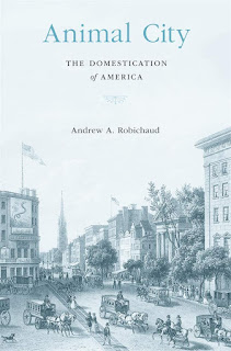
One of the segments was "Animal City: The Domestication of America," featuring Andrew Robichaud, author of the book of the same title, discussing how food animals had once been a key element of cities, dairies which I knew about and "feed lots" which I didn't, and the process of removing those functions first to the outskirts of cities and then out of cities altogether.

It's definitely worth a listen.

It's an important history that still comes up from time to time, because today's zoning regulations typically restrict animals even chickens on residential properties, and forbid even small scale slaughtering and other types of food production, including craft brewing and distillation, even large scale baking, in industrially zoned lands.

This came up last year in Alexandria, Virginia.

Their zoning regulations no longer forbid animal slaughtering and some residents opposed the approval of a small halal poultry operation ("Halal slaughterhouse and shop wins approval from divided council in Alexandria, Va.," Washington Post).

Opposition was complicated.  Some was about concerns over the potential for smell and improperly handled waste, as well as anti-Muslim beliefs or anti-meat consumption.

As a small scale operation nothing like a Swift meatpacking plant, many of those concerns were overblown, or not relevant to a discussion on zoning and allowable uses.

In the episode Professor Robichaud mentions an area of San Francisco once called "Butchertown," where animals were kept and slaughtered.

It reminded me of the real life Butchertown district in Louisville, where there is a Swift slaughterhouse/meatpacking plant (still operating today) and the distinct ever present smell of animals, at least when I was there in 2004.

Back when I ran a historic preservation study on the H Street neighborhood, one of the elements covered in the neighborhood history section was how the area had once been on the outskirts of the city, that there were "market gardens," small plots used to grow produce for sale in the city, and abattoirs, slaughterhouses for animals.

Horses.  We also discussed a bit why there were stables and carriage houses, and drayage.  When leading a walking tour once, someone asked a question about "what happened to all the horseshit?" but I didn't have a good answer.

Another book on this topic is The Horse in the City: Living Machines in the Nineteenth Century, which came out a few years after our study.

Issues around "the horse in the city" still comes up in the modern day.

Depending on the city, there may still be horse stables and public access to horse riding. Many police departments also have horse-mounted police units ("Long Legs of the Law : Mounted police units are valued for crowd control and park patrols--but training takes more than horse sense," Los Angeles Times) and there can be complaints about how they are deployed in crowd control.

(In DC, both the US Park Police and the Metropolitan Police Department have mounted police units. The US Capitol Police had such a unit for a brief time, but Congress disbanded the unit over costs.)

Other issues I am familiar with include:

• in cities like New York City, animal rights activists fight the continuation of tourist oriented carriage rides ("In His 5th Year as Mayor, de Blasio Finally Acts on Horse-Carriage Pledge," New York Times).  These horses are still stabled in the city.

• in Baltimore, "a-rabbers" sell fruit and vegetables from horse-drawn carts and animal rights activists are opposed as well ("As Baltimore's arabbers become a thing of the past, a photographer aims to preserve the tradition," Baltimore Sun").

• and in some trail planning processes, although more in suburban and exurban areas, it is common to include access to horses alongside pedestrians and cyclists. 

Food animals and cities today.  And re-legalization of small scale, "backyard" animal husbandry has been an issue for awhile.  I call the opportunity to do this with your neighbors "Block supported agriculture."  Post columnist Tamar Haspel just wrote about this in the context of the rise in chicken raising as a result of the pandemic ("7 tips for raising backyard chickens, from picking a breed to having an exit strategy").

Seattle may be the most liberal city in the US when it comes to such regulations, whereas many cities aren't interested in going that far, and may or may not be comfortable with chickens.  DC is definitely a laggard on that score.

Animal agriculture and land use master planning.  Some counties have divided their land uses in ways to permanently protect rural lands.  Baltimore County, Maryland was one of the first in the late 1960s.  The way they militate against sprawl is to refuse to provide "city water" service to rural areas of the county.

Greater Portland is known for its Urban Growth boundary, although all areas in Oregon are required to urban and rural zones as part of master planning processes.

Montgomery County Maryland has a large Agriculture Reserve, about 30% of the county's 507 square miles, although as one former planning director commented, "all that did was displace sprawl past it to Frederick County" ("Montgomery seeks new crop of farmers," Washington Post).

As rural areas suburbanize there are often conflicts between new residents and extant agriculture operations ("‘Right To Farm’ Laws Allow Ag To Be Stinky And Noisy, But Some Neighbors Cry ‘Fowl’," Colorado Public Radio; "Suburban farms meet opposition as they look to change business," Baltimore Sun; "Beer-fueled fight in Fairfax prompts officials to look at state farming law," Washington Post).  Often such disputes end up in court.

Communities with agricultural land typically have an agriculture element within their land use master plans, while cities typically do not.  Although this is changing as the interest in Urban Agriculture grows.


(Not related to animals.) 

Front yard gardening.  Another issue is front yard gardening, which many people consider "messy" and many zoning codes forbid ("The Battlefront in the Front Yard," NYT).  But depending on if you have a backyard and whether or not it gets enough sun, it might be the only option people have for growing vegetables.

Related is the concept of the Edible Landscape/Foodscaping.  More about this some other time.

Labels: , , , , , ,

Tuesday, August 01, 2017

Are historical land use conditions by definition a racist plot?

The Washington Post has an article, "Ward 5 pushes back as city moves more trucks to already industrial neighborhood," about Ward 5 residents complaining about the ward's possession of a preponderance of the city's industrially-zoned land, so they believe that continued use of this land for industrial purposes makes the ward the city's "dumping ground."

For safety reasons especially the transport of volatile chemicals through Washington, an alternative freight rail routing through Maryland was proposed by the National Capital Planning Commission.

Last summer a freight derailment in Ward 5 created problems ("In aftermath of derailment, D.C. officials turn focus to CSX and its cargo," Washington Post) and more recently in the same vicinity, two CSX employees were killed when they stepped off their freight train to check on a problem, and they were hit by an Amtrak passenger train.

Generally, industrial land in cities has been located along rivers, waterfronts, and railroad tracks.  Ward 5 has a preponderance of the city's railroad trackage as three of the four major passenger rail lines and two of the three major freight rail lines are located in Ward 5.   Since land on either side of the railroad tracks tends to be zoned industrial, most of the city's industrial lands are located in Ward 5.

Passenger
- Penn Line/Northeast Corridor to Boston
- Camden Line to Baltimore
- Metropolitan Branch to West Virginia (partly in Ward 4)
- but Union Station to Virginia is in Ward 6 (as is some of the Union Station railyard)

Freight

- the Metropolitan Branch (is primarily a freight railroad used also for passenger traffic)
- Washington Branch (from Baltimore to DC, includes what is called the MARC Camden Line)
- Alexandria Extension (in Ward 6 and/or Ward 7/8) to the RF&P Subdivision (from Union Station to Virginia Avenue to Maryland Avenue to Virginia)

River frontage in DC is no longer particularly industrial because much of it is controlled by the National Park Service and used as park land.  But Georgetown used to be a warehouse and industrial center, and the Washington Navy Yard on the Anacostia River was a major industrial site. 

Interestingly, some writings (notably John Wennersten's Ancostia: The Death and Life of an American River) recount criticisms of the park use of the banks of the Anacostia River as denying African-Americans job and business development opportunities around the maritime industry.

Conundrum of planning at three scales: metropolitan; city-wide; and neighborhood/ward. The article mentions the Ward 5 Industrial Lands Study, which I criticized for being too parochial--only looking at Ward 5, when other parts of the city have similar land use conditions--and namby-pamby in terms of providing concrete recommendations for retention of industrial land through zoning controls. See "DC Ward 5 Industrial Land Transformation Study identifies zoning issues (that I raised 6 years ago...)."

The fact is the city needs some "Production, Distribution, and Repair" land to serve its various uses city-wide. From the metropolitan scale standpoint, displacing these uses to the suburbs still requires trips to and from the city from these facilities, and there are limited entrypoints, therefore, displacing industrial uses contributes to traffic congestion.

But that means that Ward 5, because that land already exists in that zoning category, bears the majority of the costs of providing that as a "public good" to the rest of the city. (Ward 4 and Ward 6 also have industrial lands, and there is railroad trackage in Ward 7 and a semi-abandoned Anacostia Railyard in the middle of what otherwise would be Anacostia Park.)

VRE and storage.  This comes up with Virginia Railway Express program to build a storage yard in Ward 5, adjacent to New York Avenue.  It is an undesirable use.  It's not likely a preferred use.  But the railroad was there first and railroads have extranormal protections under federal law to maintain their use of land for railroad purposes.

That doesn't mean that there aren't alternatives, they just aren't cheap, and it also requires an upgrade of the Long Bridge over the Potomac River which connects Union Station to Virginia.  Currently there are only two tracks, which CSX owns.  As a result, there are limited "slots" for passenger railroad traffic.  This means that instead of running trains back and forth as round trips, VRE sends most trains into Washington one-way, and they return in the evening.  This requires that each train be stored in DC during the day.

I've recommended that by merging the MARC Penn Line with the VRE Fredericksburg Line the need for storage facilities would be significantly reduced.  See "A new backbone for the regional transit system: merging the MARC Penn and VRE Fredericksburg Lines."

Environmental Justice.  The issue of Ward 5 and Industrial Land raises tricky environmental justice issues.  Are Ward 5 residents dissed because they are primarily African-American and so the uses end up "in their ward."  Or did the residents end up there because properties were cheaper because they abutted or were near industrially zoned land?

Conclusion.  While I think all residents deserve to be protected from nuisances. But when you live by industrial land, I don't think you have the right to fight continued use of that land for PDR type uses.

Calling it "a dumping ground" is a convenient obfuscation of the facts. Someone at a presentation I was at recently talked about how easy it is to "racialize" most any issue in DC. It's easy for me to say, with my "white gaze," that's what's going on, but at the same time, it's easy to racialize issues that are not so accurately categorized in that way.

Notes.  Aesthetics.  For what it's worth, in the DC State Rail Plan, I did encourage placemaking-architecture-urban design related mitigation, to make the railroad "architecture" fit in better to the city, and some of those ideas--based on a 1902 article from House and Garden Magazine entitled, "Railroad Beautiful," did make it into the plan.

Labels: , , , , ,

Wednesday, January 21, 2015

DC Ward 5 Industrial Land Transformation Study identifies zoning issues (that I raised 6 years ago...)

I was not prepared to be impressed about this study because the impetus for the planning process was a desire by the Ward 5 Councilmember, Kenyan McDuffie, to reduce the amount of industrially zoned land in DC's Ward 5.  DC has a limited inventory of industrial land and mostly it is located adjacent to CSX and Amtrak railroad tracks, which are mostly located in Ward 5.

-- "Can Ward 5 go from 'dumping ground' to industrial area that works," Washington Post
-- "McDuffie resolute on helping his ward shed image of a dumping ground," Washington Post

(Another large swath of industrially zoned land used to exist on the Southeast DC Waterfront but have been rezoned for the creation of the Washington Nationals baseball stadium and various mixed use developments that exclude industry.)

But the planners successfully repositioned the study around the economic development value of industrial land and its essentiality to creative economy endeavors and the related employment that is generated, and the Councilmember became convinced that it would be worthwhile to preserve industrially zoned land rather than get rid of it, provided that the nuisance elements can be better managed, as well as to support various municipal and transit uses that can only be accommodated within such zones.

Warehouses on Reed Street at Channing Street NE
The building on the right was demolished a few months ago and this warehouse site will be redeveloped as housing.  

Granted, this Ward 5 site is just north of the Rhode Island Metrorail Station and the city has conflicting policies--one is to preserve industrial land (although without substantive protections in zoning) and another is to build multiunit housing by transit stations.

Unfortunately, these days DC is late to the table.  It happens I saw a great presentation on such issues by San Francisco at the 2004 American Planning Association conference, and in 2005 at the National Trust conference in Portland, one of the field tours I attended was of the Central Eastside Industrial Area.

-- Industrial Land in San Francisco: Understanding Production, Distribution, and Repair, San Francisco (December 2002)
-- Central Eastside Portland Urban Renewal District, Portland
-- Central Eastside Industrial Council
-- Central Eastside Industrial Zoning Study (December 2003)
-- Industrial Land Reports from Cities and Regions throughout the US and Canada, UC Berkeley Center for Community Innovation

Back then I was interested in industrial zoning issues because of the Florida Market and the redevelopment threat--now coming true--it faced, and opportunities present within Ivy City for creating streetcar manufacturing and a preservation building trades training program. Note that DC did do a study around 2005, but I guess nothing much happened with it, other than the recognition that a lot of municipal-related uses need to be located on industrially zoned land.

-- Industrial Land in a Post-Industrial City: District of Columbia Industrial Land Use Study (2006)

Now, in a reasonably strong real estate market with a limited inventory of large sites across the city, it is almost impossible to preserve industrially zoned land, unless it is already owned by industrially-related firms--and for the right price, who is to say that they won't be willing to decamp too?

Vodka, Gin, and Whiskey are manufactured in DC at the OneEight Distillery in Ivy City.  It was the second distillery to open in DC in the past few years.  Small breweries are also located on industrial properties in Wards 5 and 4.

As the study pointed out, DC's industrial (both manufacturing and commercial-manufacturing) zoning categories have extremely permissive zoning, and because of the value of the proximity of the land in a strong real estate market, increasing amounts of this land are being converted to non-industrial uses--big box retail, schools, housing, etc.  (This was also discussed in the previous entry on New York Avenue.)

One of the study's recommendations is "to do more study of the zoning issues."  It's too late, the zoning needs to be changed now.  And how much more study is even necessary?

Ironically, I submitted an amendment to the Comprehensive Land Use Plan on this verysame issue in 2009, the first year that amendments were solicited by the Office of Planning. I recommended that matter of right use for schools and churches be removed from both CM and M zoning categories.

This large building is now the Imagine Hope Public Charter School.  It was once an industrial building, and abuts various industrial properties along 8th Street NE.  Image from Google Street View.

I also suggested that there could be a requirement that the zoning should require that first floor use of industrially zoned properties be from 50% to 100% industrially related--which would make conversion much more difficult.

This was the justification I provided:
According to page 3-6, 1% of the city's land is zoned for industrial use. Land use by industrial users is guided strictly by business considerations. Industrial businesses cannot efficaciously use noneconomic considerations to make decisions about buying and leasing property and managing their business. This is not the case for nonindustrial users, who have different criteria. But nonindustrial users allowed to locate their businesses-establishments in industrial zones are not guided by the same economic and business model constraints which must be exercised by industrial users. Schools and churches in particular continue to convert CM land into non industrial use, displacing industrial
businesses to the suburbs, adding to the traffic burden, and making it harder to serve DC residents and businesses. By extending land use protections to CM zones, this conflict can be reduced and avoided.
I failed to mention specifically that nonprofit users (schools and churches) don't pay property taxes, which further aids their ability to outbid for profit users.

This amendment WAS REJECTED because they said the zoning code was adequate and already restricts non-industrial uses.  They said:
The amendment is not a substantive change in policy, nor does it correct an error. The CM zone already limits non-industrial uses. This issue is also being addressed through the ongoing Zoning Review process.
First, it is not true that the CM zone matter of right uses limit non-industrial uses in any significant way, other than housing.

Second, almost nothing has been passed as part of the Zoning Rewrite Process in 8 years. Third, we continue to lose industrially zoned land to nonindustrial uses.  Fourth, the 2014 Ward 5 Industrial Land Transformation Study says that this is a serious and significant issue that continues to be something that must be addressed in zoning.

It's no wonder the city continually fails and is constantly behind the curve when it comes to best practice.

I guess this happens in part because there are never substantive repercussions for when staff make bad decisions that have significant and negative consequences.

=====
Note that one other problem with the study is that it was limited to "Ward 5," when Ward 4 also possesses a swath of industrially zoned land with the same land use and market conditions, yet there are no such recommendations for dealing with it, because it wasn't part of the study.

Labels: , , ,

Tuesday, January 20, 2015

Greater New York Avenue Gateway revitalization organization (and the loss of industrially-zoned lands)

Received email from a new organization spearheading revitalization for New York Avenue in the Northeast quadrant of DC.

-- Greater New York Avenue Gateway Group

with an upcoming meeting on Thursday January 29th.

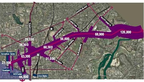
New York Avenue, DC, Existing Average Daily Traffic Volumes (2000)Traffic volumes on New York Avenue, circa 2000.

Generally, the corridor has been marked by the reality of its serving as a traffic-engorged entry in and out of the city, serving as a connection between the Baltimore-Washington Parkway, I-95, and Rte. 50 and I-395 in DC and Virginia.

That makes it pretty grim.  Plus it's bracketed by train tracks and a major train yard on the north side.   A Costco opened in the corridor a few years ago and does very well, but while satisfying consumer demands, doesn't make the corridor look any better.

In general, the New York Avenue corridor doesn't offer much in the way of high quality placemaking or entryway characteristics.

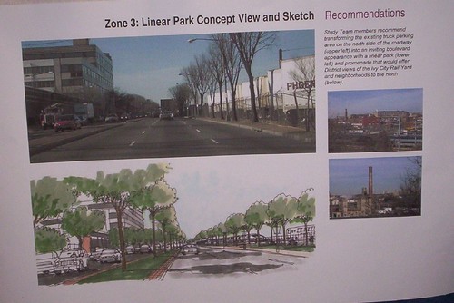
The city did a plan in the early part of the last decade that had some great ideas, and addressed the entirety of the corridor from the DC-Maryland line to where it joins I-395 around 3rd Street NW.
New York Avenue Corridor public meeting
After this there was an attempt by Abdo Development to develop a big section of it, between Montana Avenue and Bladensburg Road, but that fell through after the 2008 real estate crash.  Another plan for that section was for a Walmart-anchored shopping center, which also fell through.

Since then, the prominent local real estate development firm, Douglas Development, has made a big investment in buying the historically designated art deco Hecht's Warehouse and a lot of the adjoining properties, including the 17-acre section once controlled by Abdo Development.  I don't know the exact amount, but it must be in excess of 50 acres.

They are converting the Hecht's into apartments, with retail on the ground floor and in adjoining buildings.

-- Hecht Warehouse District, Douglas Development Company
-- Washington Business Journal article

I think they are somewhat "crazy" a/k/a "ahead of the market," because the area is somewhat of a no person's land, distant from quality transit and definitely not particularly "walkable" and automobile-dependent.  That will change as more of the area gets repatterned.

Rendering of a DMU unit in MBTA Boston livery from BostonInno.  Note that this shows the possibility of a single railcar powered by electricity, which is more efficient than diesel.  A DMU integrates the engine into a single car, allowing for significantly smaller train sets and more frequent service. 

And as residential development and activity increases, an idea I once saw as crazy, adding an infill MARC railroad station at Bladensburg Road ("McDuffie suggests a Bladensburg Rd MARC or Metro station," BeyondDC), starts to make sense. Especially if it were possible to provide a type of transit service using Diesel Motive Units, something Boston is pursuing for one of its city-serving lines ("MBTA to purchase new trains, open new Blue Hill station," Boston Globe). This would allow for more frequent service, treating the railroad line as a kind of more frequent subway line, providing a type of fixed rail transit service that the corridor doesn't enjoy now.

A MOM Organic Market opened in November 2014 and despite my questioning the likelihood of success ("Sometimes a bad idea is just so obvious: MOM organic grocery on New York Avenue NE") allegedly it is already one of their highest-performing stores.

Other retailers and restaurants are announcing plans to open there.  Although my understanding is that retailers are getting sweetheart deals, which makes sense, because the retailers are taking big risks by locating there now, when the base of immediately located customers is low and most people will have to drop to shop there.

2.  Interestingly, I would argue these plans are somewhat counter to the recently produced Ward 5 Industrial Land Transformation Study, which recommended that industrially zoned land in the ward be preserved to support provision of space for "production, distribution, and repair" businesses, as well as the development of the creative economy by providing access to flexible spaces and artisanal production of food and beverages, as well jobs preservation and development.

These projects subtract 5% to 10% of the ward's industrially-zoned land in one fell swoop.

Labels: , , , , , ,