Extending the "Signature Streets" concept to "Signature Streets and Spaces"
=============
Updated:
Republished on Saturday September 5th, from Friday September 4th, because I significantly revised the sections starting with "Additions/Sustainable Mobility Platform"
=============
There is an article in the Cleveland Plain Dealer ("Lakewood plans all-purpose trail, streetscaping and public art for Detroit/Sloane intersection") about the City of Lakewood planning to make urban design and placemaking upgrades to a particular intersection which because it is across a bridge from Cleveland, is an inadvertent gateway to the city.

Photo by John Benson of the intersection of Detroit and Sloane Avenues in Lakewood, Ohio.
The article mentions they recognize the importance of making it a gateway to the city, will add a trail connection to a nearby Metropark, include public art, etc.
And yesterday, driving down a huge road in Salt Lake County, 5400 South, which has at least 3 lanes in each direction plus some reversible lanes in the middle, I saw three little urban design elements on what is otherwise a wide expanse of concrete: (1) signage on the Bangerter Highway overpass, identifying it; (2) a small section of plantings in one area, probably done by the City of Kearns; and (3) a sign far too small to read saying something about a parkway.

Motorists travels along Bangerter Highway at 5400 South in Salt Lake County Thursday, Jan. 14, 2016. Jeffrey D. Allred, Salt Lake Deseret News. ("In our opinion: Utah recognized for transportation infrastructure investment").
So I am reminded that it's worth revisiting the "Signature Streets" concept I came up with in 2010 when I was working for Baltimore County, Maryland, at the very end of the development process for the Western County Pedestrian and Bicycle Access Plan.
The basic idea was built upon the realization that the set of primary arterials in a community is the foundation of its mobility network and the aesthetic qualities, positive or negative, shape the perceptions of the community.
I didn't have time to fully develop it or sell it to the advisory committee, who couldn't grapple with it as a concept different from the competing "Complete Streets" program. The difference is that Signature Streets aims for a bigger scale and platform and packages broader identity systems and funding mechanisms.
Still, a couple of its elements made it into the plan's recommendations, including a zoning change that recommended putting parking behind buildings on arterials where normally the parking is in front of the buildings.
Then I went on vacation. After coming back, I came across a presentation by David Barth and Carlos Perez, then both at Glatting Jackson/AECOM, which included a diagram that perfectly expressed my thinking about what I called Signature Streets, which was, as they called it "The Public Realm as an Interconnected System."

Public Realm as an Interconnected system, Slide from presentation, "Leadership and the Role of Parks and Recreation in the New Economy," David Barth and Carlos Perez, AECOM.
Although "Linkages" don't appear to be co-equal in the display within the graphic, and in the Signature Streets concept they are. My graphic idea was each mode would be rendered like a NYC subway map, side by side by in different colors for each mode--walking, biking, and transit.
The reality is that designs for most arterials do not prioritize aesthetic or place considerations. Note that the "parkway" road type, typical of the 1920s and 1930s is an exception.
The challenge is to balance mobility, commercial, and aesthetic-place priorities in street design, in a land use and transportation planning paradigm that focuses mostly on prioritizing traffic throughput.

But it was pioneering in terms of providing a framework for matching mobility infrastructure to land use context, rather than building all roads to support traffic moving at freeway speeds.
Since this was published in 2008, more communities have come up with more detailed and expanded guidance on what can be done.
Some examples include San Francisco's Livable Streets program and the new Street and Intersections Design Typologies proposed by Salt Lake City.
Not only does the SLC guide overtly include intersections as an element to be planned for in special ways, it formally expands the definition of the functions of the street right of way in two ways. First, it includes "person mobility" as equal to automobile movement and throughput -- this isn't a new concept, which focuses on throughput of people overall, making the point that single occupant automobiles are inefficient.

Second, it identifies greening and placemaking as functions that should be planned for and integrated within projects.
The Signature Street idea. The concept was sparked by all the various meetings I had with other agencies, our public planning meetings, smaller meetings with stakeholders and community groups, research and writing for the plan, exploring funding mechanisms, etc., but probably what touched it off was a meeting in January with citizens requesting desired design improvements on one arterial that was also neighborhood serving, and actually under the jurisdiction of the County Department of Public Works--whereas most high volume arterials are under the control of the Maryland State Highway Administration (which is true for all such roads across the state--SHA runs them, not the local jurisdiction).
It wasn't til mid-June when all this combined into the unified "Signature Streets" concept where based on what I call action planning ("Best practice bicycle planning for suburban settings using the "action planning" method") about integrating program delivery and branding and identity systems into planning processes using the design method, I realized the "hook" in selling improvements as an integrated program should be out of the recognition that the road network is the primary way in which a community's identity is shaped.
.jpg)
A typical arterial with minimal placemaking qualities,
nor accommodations for transit, walking, and biking.
.jpg)
Looking north along Bothell Way Northeast’s “multiway” boulevard in downtown Bothell, Washington. Photo: Steve Ringman, Seattle Times.
Signature Street Model
This should include public art, special crosswalk and intersection treatments, and the integration of improvements to adjacent public spaces more generally.
Baltimore County's streetscape program was focused on commercial districts, but could be extended to include areas around cultural and other civic assets, etc.

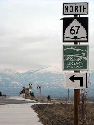
Utah's Legacy Parkway (State Road 67) has a logo, which is used in various signage along the route.
(I also proposed created a common identity and branding signage system for the county's civic assets like libraries and parks.)
.jpg)
Photo: Brian Myrick, Idaho Press.
-- Neighborhood Identity Kit Process, Boise, Idaho
(7) with all of these elements in combination to support the case for financing using bonds and winning the vote in favor of the bond referendum, therefore raising the funds to pay for the development and enhancement of the upgraded mobility network and acquisition of the necessary right of way.
Funding is key. In most communities (not DC), to expand the right of way, you have to buy the land. That's expensive. The government doesn't want to do it.
But by positioning "Signature Streets" in terms of extending and enhancing the road system by adding elements that build a more complete mobility network that enhances quality of life and making the argument that the county's residents "deserve" a mobility system that meets 21st Century needs, and in keeping with the fact that the County is the third largest jurisdiction in the State of Maryland makes this kind of re-thinking achievable.
The model that I suggested was Seattle's Bridging the Gap initiative (it's now called Move Seattle). Another example which I learned about later is the "Metropolitan Area Projects program in Oklahoma City, which is a capital improvement program focused on delivering transformational projects, funded by a sales tax surcharge.
Additions/Sustainable Mobility Platform
In terms of additions or expansions of the original post, probably the way to do it is to stick with the 7 points, and have appendices for each of the points with more detail.
One way to approach thinking about the mobility elements is using the Sustainable Mobility Platform Framework. It needs another iteration of codification, but it aims to provide thorough coverage of the options within each mode.

So today many suburban communities have to re/build central places to define their communities and create placemaking opportunities.
-- Ten Principles for Reinventing Suburban Business Districts, Urban Land Institute
-- Ten Principles for Reinventing America's Suburban Strips, Urban Land Institute
-- CENTER POINT Master Plan: Vision Document and Small Area Plan, Taylorsville, Utah
The Taylorsville Plan for recreating an city center out of unconnected shopping centers located at the "100% intersection" of the community, which had once been the crossroads for the area and the location of a more traditional town-like commercial district, has a number of interesting approaches for defining place and adding support for modes other than the car.
More on Biking as transportation. Obviously, since the plan for Baltimore County was for biking and walking, it shouldn't be a surprise that earlier in the planning process, I came up with a framework for planning the bicycling (and walking) network in a more systematic fashion, at different scales:
- within neighborhoods
- one mile radius from schools and bus stops and transit stations
- three mile radius from "town centers"
- along corridors
- between corridors
- connections within and to parks, which I called a County bikeway network
- connections to neighboring jurisdictions (Baltimore County has borders with Baltimore City, Anne Arundel County, Howard County, Carroll County and Harford County in Maryland, and York County in Pennsylvania.
A great example of connections between jurisdictions is how the State park managed Northern Central Trail, which uses an old railroad line from Lutherville to the York County border, is further extended by York County to the City of York.
York County terms the trail the York Heritage Park, and has some great trailhead signage.

York County terms the trail the York Heritage Park, and has some great trailhead signage.
I didn't think to include planning for the bicycle network as a separate point, instead it's incorporated into point #5.
Relatedly, while it goes without saying that accommodations for cars are included within the road network, although most are provided by the private sector, for bicycling to be practical form of every day transportation, a network of biking infrastructure needs to be complemented with parking, repair stands, air pumps, mapping, etc.
A way to think about this for biking would be to extend the ideas of the Pennsylvania Trail Towns tourism promotion scheme to amenities, alongside a concept put forth in the German National Bicycle Plan, 2002-2012, that to treat "cycling as traffic," more than just the pathway space is required.


Salt Lake City has created a "Cycle The City" route as a kind of tourist route to see points of interest via bicycle.
The inclusion of these kinds of support facilities should be incorporated into the biking element of a "Signature Streets and Spaces" program.
More on Transit. Similarly, a system for integrating improvements and enhancements to the transit network should be outlined in a more formal way.
Blog entries
-- "Making bus service sexy and more equitable," 2012
-- "Transit, stations, and placemaking: stations as entrypoints into neighborhoods," 2013
-- "Branding's (NOT) all you need for transit," 2018
-- "Bus shelters as social spaces," 2020
-- "Takoma Langley Crossroads Transit Center: a critical evaluation," 2016
-- "Revisiting the review of the Takoma Langley Crossroads Transit Center, 2019
Design Guides
-- Rethinking the Suburban Bus Stop, Airport Corridor Transportation Association, Pittsburgh
-- Modern Trolley Station Design Guide, SEPTA
-- From Here to There: A creative guide to making public transport the way to go, EMBARQ, World Resources Institute


Pearl Street Pedestrian Mall, Boulder, Colorado.
In a recent piece, I suggested that regardless of the pandemic every city should have already been developing one pedestrian-exclusive spaces akin to Las Ramblas in Barcelona, Mare Street in Hackney, London, etc.
-- "From more space to socially distance to a systematic program for pedestrian districts (Park City (Utah) Main Street Car Free on Sundays)"
-- "Why doesn't every big city in North America have its own Las Ramblas?"
-- "Diversity Plaza, Queens, a pedestrian exclusive block"
More on Funding. Another funding method is special service districts. I've discussed that in terms of what I call Public Improvement Districts for transit station catchment areas ("Revisiting creating Public Improvement Districts in transit station catchment areas").
San Francisco has the Green Benefits District concept, which is funded by a surcharge on both residential and commercial properties, to improve and maintain public spaces.
More on Public Art. There are many interesting ways and resources and examples for thinking about how to incorporate public art in the public space and as an element of the placemaking qualities of the mobility network.
For example, I've always thought that Cincinnati's Neon Sign Museum could create a signage public art program for the erection of arty signs throughout the city.
Two interesting projects I've come across lately are the Streetscape Improvements Playbook of the Memphis Medical District Collaborative and a city-wide project currently underway in Marseille.
Sponsored by MAMO, the city art museum for Marseille, the public artist known as Invader, who installs tile mosaics in public spaces across France, was commissioned to place 80+ works throughout the city ("French Street Artist Invader Secretly Installed His Art All Over Marseille This Summer—See It Here," Artnet).
As well as art works within transit stations and shelters or as elements of the stations, such as Centro Tower at a bus station in San Antonio by Bill FitzGibbon, incorporating light elements into bridges, etc.

High Trestle Trail art bridge, Madrid, Iowa
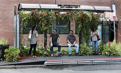
Everett, Massachusetts Bus shelter adorned with flowers by local artist Krissy Price. Photo: Pat Greenhouse, Boston Globe.

Avenues neighborhood concept and designer statement by Drew Taylor.
More on Branding. A group of graphic designers organized as The Neighborhood Project created logos for Salt Lake City's neighborhoods ("From the Avenues to Rose Park to Sugar House, designers give Salt Lake City neighborhoods their own logos," Salt Lake Tribune).
An identity system for Signature Streets needs to go beyond sign toppers for street signs.
Some places have gateway signage for places like neighborhoods and districts and commercial districts.


This sign produced by the Downtown Yonge Business Improvement Association in Toronto is gateway signage and public art.

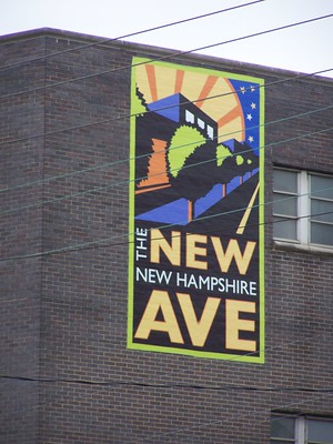 The City of Takoma Park came up with a logo as part of their New Hampshire Avenue revitalization program called "The New Ave." It's an example of branding a Signature Streets program.
More on marketing. Using events that promote sustainable mobility, e.g., the "Sunday Streets" program in New York City or the CicLAvia in Los Angeles is another way to market the Signature Streets network in an ongoing fashion.
This is necessary for the promotion of sustainable mobility as well as building ongoing commitment to maintaining, improving, and expanding the network, especially if funding needs to be re-approved every so often.
-- European Mobility Week
-- Open Streets Toolkit
-- Complete guide to parklets & streeteries, Parkade
Transportation infrastructure as architecture. More places are incorporating urban design and public art elements into transportation infrastructure, such as freeway abutments and overpasses, decorative plantings, etc.

A public art approach to freeway abutments and overpasses, Loop Freeway 202, Phoenix. Photo: Sky Schaudt, KJZZ/NPR ("Q&AZ: Who Designs The Artwork Along Arizona Freeways?)."
Streets as linear parks. Greening and plantings are an obvious addition to "roadsides", especially in commercial districts and town centers. Because of the expense of maintenance, such urban design improvements may be left out of plans. But this can be an important element of improving the aesthetic experience within the road (mobility) system.
The "parkway" approach from the 1910s-1930s is the obvious relevant design example that can be drawn upon for ideas.


Salt Lake County turned dirt on the "Gateway to Kearns," a four-block-long stretch of land on the south side of 5415 South that will be converted from a weed patch into a parkway including the county's first urban orchard with apples, peaches, pears and cherries. ...Conflicts: the challenge in developing a Signature Streets network when streets cross jurisdictions.. A challenge for planning an integrated Signature Streets network is when road spans multiple jurisdictions, which is pretty typical for arterials. The concept is developed out of center cities that have significant control of the roadway and roadside characteristics of the mobility network within their cities.
"Kearns is maturing. Kearns is turning into a world-class community," said state Rep. Eric Hutchings, a resident. "To improve our look and feel around here means a lot."
He lauded Salt Lake County for "putting its money where its words are" in funding development of the parkway at a time when Kearns residents showed their appreciation for county leadership by voting to become a metro township.
Baltimore County doesn't have incorporated cities so the County is the primary actor. In other counties, a mix of state, county, and local jurisdictions is responsible, with the local jurisdictions responsible for the roadside, the state department of transportation responsible for major arterials, and a mix of jurisdictions responsible for other streets.
5400 South in Salt Lake County is a perfect illustration. Taylorsville wants to recreate its center at the intersection of South Redwood Road and 5400 South. Kearns, on a section of the road, but only on the south side, has invested in plantings. But overall the road functions like a big, wide highway, lined with a mix of industrial and commercial buildings most barely designed. There is no design coherence as the road crosses jurisdictions.
Corridor management as a solution. In these situations, what is required is an overall multi-jurisdictional "corridor management" approach. This could be a way for counties and state departments of transportation to provide guidance and leadership on the urban design and sustainable mobility elements of the "road network" that goes beyond today's more traditional and disconnected approach.
-- "Transportation network interruptions as an opportunity: Part 2
-- "Transportation network service interruptions part 3: corridor/commute shed management for Northwest DC and Montgomery County, Maryland
Conflicts: transit. Another conflict between jurisdictions concerns transit operations, especially when transit agencies are run on a metropolitan scale.
Labels: civic architecture, public realm framework, sustainable mobility platform, Transformational Projects Action Planning, transportation planning, urban design/placemaking
posted by Richard Layman @ 9:20 AM&Permanent Link
![]()
![]()


3 Comments:
5. The entire Motorway vs A-road system needs a rethink
The potential is huge and exciting. There’s nothing like overland travel for connecting you with a place. Walking and cycling are best, but motoring allows you to scoop up the miles, survey landscapes, compare and contrast, and think of the UK as a whole. The motorway vs A-road arrangement, more than sixty years old, needs a rethink. We drive for different reasons than we did in 1958, when the Preston Bypass was unveiled to a thrilled public. Many more of us are at the wheel. What we need, for motorised travel to take off in the EV era, is vision and imagination, allied to reason and experience. What we currently have is a botch job and lots and lots of cones.
The next time I need to do a long trip I’ll go at night – there’s something magical (and empty) about our motorways after dark. Should an accident take place, I’ll park up, ideally at a services like the one at Gloucester, and sit it out. The last year or so of lockdowns and travel bans has forced us – the public, I mean – to think hard about holidays and domestic travel. Let’s hope someone in Government is inspired to reimagine our road network. Until it’s improved, we should expect crashes, jams, breakdowns, busted bladders and other calamities, and a diet of awful fast food to be poorly digested while we chug along in the tedious, unending slow lane of British making do.
https://www.telegraph.co.uk/travel/comment/had-epiphany-gloucester-service-station/
I had an epiphany in a Gloucester service station
2. All service stations should look to Gloucester for tips
An epiphany at Gloucester services. I had been past the “Farm Shop” services many times, but the hunger and fatigue consequent on removals took me to both sides of these magnificent services on more than one occasion. The coffee was excellent, as were the wraps and pies. But what was also striking was how easy on the eye the décor was; instead of the primary colours and plastics of your average Moto, Welcome Break or Roadchef (service stations being another quasi-monopoly born of fake free markets), Gloucester is woody, beige and cream. It has little huts outside where you can eat, quietly and safely. There are lawns scattered hither and thither.
There is no justifiable reason whatsoever why the rest of the system cannot look and feel like this. We did use other services up and down the M5 and M6, for petrol mainly, and coffee (thankfully, Costa seems to have trained staff to stop delivering scalding Horlicks under the guise of “latte”), but the best food available there was in the M&S and Waitrose outlets – cold, pricey salads and such. Across Europe and South America, pausing on a drive is often a pleasure. Until the franchises are reformed, I’d recommend taking a tupper and a flask. The Government should ban fast and sugary food from motorway service stations or else insist all sites have at least 50% of their estate occupied by healthier alternatives, and should appoint food-quality inspectors to accompany its hygiene, health and safety beadles. Any outlet not offering food conducive to alert driving and general buttock-leanness should be issued with a warning and given a single chance to clean up, and slim down, its act.
We need French-style “aires”, more lay-bys, more WCs, motorhome parking spaces, campsites; we need all kinds of things to turn the roads into destinations in their own right, as well as ways of getting from A to B.
https://www.telegraph.co.uk/travel/comment/had-epiphany-gloucester-service-station/
I had an epiphany in a Gloucester service station
Rome is creating a pedestrianized district in the city, focused on the archeological sites like the Coliseum. Major European cities tend to have them.
https://www.nytimes.com/2024/04/02/world/europe/rome-future-past-downtown.html
Post a Comment
<< Home