Zoning redo in Miami: and 21st century planning and zoning in DC
The "Miami 21" (21st century) plan calls for more of a smart code and mixed use approach to planning and zoning in the City of Miami. (We know Miami is dangerous and in need of such a change because of watching all the murders on "CSI: Miami" and the mayhem on USA Network's "Burn Notice.") Smart coding focuses on building form more than it does on use. Traditional zoning is use oriented, and is focused on separating uses, while smart coding philosophically supports mixed use.
The Miami Herald has a story about this today, "Can Miami 21 plan replicate Biscayne Boulevard's revival?," subtitled "A once-seedy area of Biscayne Boulevard has been brought to life. Could the Miami 21 rezoning plan do the same for the rest of the city?"
Some of the opposition centers around a belief that a wholesale change in the planning regime is perilous. From the article:
``We want pedestrian cities, we want parks and green space. No one disagrees with that,'' said architect Bernard Zyscovich, a New Urbanism critic. ``But it's a wholesale change for the city, like a heart transplant, and the consequences haven't been thought through.'' ... Land-use lawyer Carter McDowell, a leading critic of Miami 21, says other changes, including new fees for building super-tall, amount to an illegal restriction of property rights.
Zyscovich says the city can get the urban-friendly design it wants without Miami 21 by requiring that garages be screened or concealed with retail and residential units at ground level. ``If you simply do that, you don't have to change the whole code, and you leave the architect freedom to do a better building,'' he said.
Paradoxically, neighborhood activists say Miami 21 doesn't go far enough, failing to accomplish the goal that gave rise to the effort: limiting the size of tall buildings abutting low-scale residential areas.
In some places, including Southwest 27th Avenue, Miami 21 would allow overscaled buildings next to single-family and duplex neighborhoods, they complain. And although the tall structures would have to step back from their smaller neighbors in a stair shape to lessen their intrusiveness, critics say that doesn't solve the problem.
There are two issues in Miami, changes in the rules and paradigm and a fear by some quarters that the design is supposed to be new urbanist only. The latter fear comes about because the prominent new urbanism architecture firm Duany Plater Zyberk led the plan. (DPZ is based in Miami, and Elizabeth Plater-Zyberk is the dean of the school of architecture at the University of Miami.)
But the article about improvements on Biscayne Boulevard don't sound all that "pathbreaking" anymore, it's merely an example of mixed use revitalization, comparable to what is happening on U Street NW in DC, Bethesda Row in Bethesda, changes in the Wilson Boulevard corridor in Arlington County, Virginia, etc.
There is no question that in today's retail/commercial/residential environment, at least in cities, it is better to mix uses rather than to separate these uses. Although at the same time there are conflicts (such as noise, see "Residents of Washington's U Street Corridor Tired of Area's Noise" from the Washington Post about night and weekend noise bothering residents in the U Street neighborhood) that aren't fully rectifiable except through self-selection--people who can deal with the conflicts live there and people who can't eventually ought to move out and live somewhere more congruent with their preferences.
Interestingly enough, the kinds of concerns expressed about Miami 21 in the above-cited article are similar to some of the concerns that have been expressed in public meetings about the forthcoming changes to DC's zoning code. (See the DC Zoning Update website of the DC Office of Planning for much much more.)
Many people are comfortable--even if they don't like it--with the current system of regulations and myriad overlays because they know how it works and they helped create it.
But, the question of whether or not does the current planning and zoning "regime" generate as a matter of course the kinds of preferred outcomes that extend the livability of the city while at the same time making the city a good place to work, invest, and visit? never comes up.
I argue that the present system doesn't work very well on that basis, and that the number of overlays that exist and the clamor for more of them should be seen as an indicator that the current paradigm doesn't work very well.
On the other hand, I can't buy into the new paradigm of 100+ zones--that every neighborhood can create their own zoning and criteria because that extends the possibilities of parochialism to new and likely unparalleled heights. (Like Chicago where Alderman have the final say over development projects in their districts. That's crazy and clearly a violation of the 14th Amendment to the Constitution.)
One key problem is that it is intended that the basic paradigm will change and go into effect before neighborhoods have responded and created neighborhood-specific criteria.
Justifiably, this has some neighborhood activists concerned, because the typical developer isn't known for caring too much about context and form as much as they are about maximizing the profit from the building (typically this means maximizing the building envelope while minimizing the quality of the material and design of the building).
I argue a third way, a more middle position. I think that the activists are right that developers will drive any truck they can through opportunities, and I fear moving to more of a "matter of right" process, when developers and property owners can do so much damage with matter of right as it is.
But at the same time we need to promote mixed use "complete places" and the ability to energize the streets, commercial districts and neighborhoods in the city that may languish without recognizing that the principles of urban center city success are not necessarily congruent with a focus on automobility.
(The quote at the top of the blog, "A community’s physical form, rather than its land uses, is its most intrinsic and enduring characteristic" comes from this report, Getting To Smart Growth 2.)
My third way uses concepts developed in Nashville's Community Character Manual. It is based on the idea of the transect, a continuum of development scale and intensity that is most "open" in the rural zones (T1 and T2) and most dense and mixed in center cities (T5 and T6).
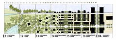
Transect diagram.
What the Nashville approach does is provide a set of subtypes within transect zones depending on the broad nature of the use--is it open space, residential, a commercial and/or civic district, or a corridor?--and then provides more specific transect planning guidance accordingly.
I think this type of framework makes the most sense. There isn't a justification for 100+ different use zones within DC. The reality is that depending on density, there are a basic set of subtypes/subzones. The Community Character Manual lays this out by transect zone, considering the four elements mentioned above: open space; neighborhoods (residential areas); centers; and corridors; and then applies the preferred policy intent such as "preserve," "enhance," and/or "create," to yield from 4 to 8 sub-zones for each transect category.
Nashville is combined with Davidson County in one political and planning jurisdiction, so their manual covers all the T zones. But for the most part, DC's land use is focused on the urban transect zones, which in the Nashville manual are categorized as T4: Urban, T5: Center, and T6: Downtown. (There is also a special district category for campuses of various types.) (Some elements of the T3 zones apply to certain outlying areas of the city outside of the core, inner city, and other more densely developed parts of the city that might not be in the core.)

Delineation of transect subzones in the T4 category, from the Nashville Community Character Manual.
In the Nashville system, the T4 zone has 8 subzones; T5 has 4 subzones; and T6 has 5 subzones. And these are the T zones that would cover, if extended to DC, much of the city, meaning 17 "zones" instead of 100+.
But it's not all matter of right. As one of the documents state, in T5 and T6, "Density and intensity and its appropriate form are established through the Community Planning Process or
Detailed Design Plan Process."
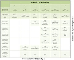
Intensities of Urbanism table by Bruce Donnelly.
Considering concepts from the Nashville Community Character Manual in the DC Zoning Update process could both strengthen and simplify the zoning update, providing stronger guidance while managing conflicting goals of no change (preservation) vs. change.
Bruce Donnelly's intensity of urbanism table is a different way to consider the issue, but the basic idea is the same. The Nashville manual neatly ties density, urban form, and use into one coherent policy and planning framework.
Labels: Growth Machine, land use planning, progressive urban political agenda, sustainable land use and resource planning, urban design/placemaking, urban revitalization, zoning
posted by Richard Layman @ 4:12 PM&Permanent Link
![]()
![]()


0 Comments:
Post a Comment
<< Home