DC Union Station EIS FRA -- Comments due November 9th
Union Station is Washington DCs primary train station. Amtrak put forward the idea of station expansion along with other capacity and other improvements on the Northeast Corridor a few years ago ("Union Station Master Plan," June 2012) and that touched off a more detailed consideration of the prospect.
A couple weeks ago the Federal Railroad Administration had their second open house on the Environmental Impact Statement process. The materials are online now and comments are due next Wednesday.
The station is unique (a word I try not to use too often) in the US because it is actually owned by the Federal Government/Federal Railroad Administration, although it is managed and operated by the Union Station Redevelopment Corporation.

The project should strive for national best practice intermodal connections. My comments will argue that because the station is owned by the FRA, there is an opportunity to make the station a national best practice example for multi-modal connections especially.
Therefore, my comments will focus on how the station area handles access for pedestrians, bus transit, tourist buses, bicyclists, taxis and other for hire vehicles, charter buses, inter-city bus transit, and personal vehicle passenger drop off and pick up, plus access to the Metrorail station, and treating a number of intersections in the vicinity as a system (North Capitol and Massachusetts Avenue, 1st. Street NE and Massachusetts Avenue, 2nd Street NE and Massachusetts Avenue, G Street NE between North Capitol and 1st Street NE/the Metrorail Station entrance).
The B scenarios in the alternatives analysis propose underground parking. In the B scenario I will propose moving taxi pick up and drop off services underground as well, comparable to how Denver's Union Station has an underground bus terminal as part of the rail station, moving bus service to and from the station off the surface streets (although the 13th Street transit mall is still adjacent to the Station).
Underground bus concourse, Denver Union Station. Flickr photo by Jesse Varner.
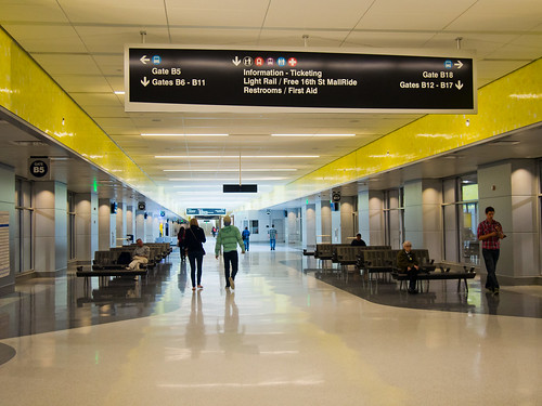
I think the Denver bus concourse serves both intra-city and inter-city bus transit, while local bus transit and inter-city bus transit are handled separately for the most part at DC's Union Station.
Simultaneously, DC has also been working on the State Rail Plan ("New State Rail Planning Initiative in DC," September 2015) and there are plans to extend the streetcar to Georgetown, and there are upcoming public meetings on that project.
-- District of Columbia State Rail Plan
-- Union Station to Georgetown Streetcar Transportation Improvements Environmental Assessment webpage, Next public meeting, Thursday, November 17th, 2016
It doesn't appear as if the train shed in the FRA plans will extend to H Street as it did in the original Amtrak concept, and I wonder if that will constrain the ability of the various rail services to grow to their maximum capacity. That is something I will be commenting on as well.
Of course, Union Station can't really grow to its maximum without additional Metrorail service. The Metro Forward program calls for providing additional service, but not in the same manner as the original "separated blue line" proposal from c. 2002. I prefer a program more comparable to the original proposal, which would provide new stations and service east of Union Station.
Penn Station, New York City. Neither Grand Central Station nor Penn Station in New York City -- the two stations in the US with the most daily users -- Union Station trails them significantly, have particularly great connections on the surface. By contrast many of the main train stations in Europe excel on this dimension.

-- "Penn Station Reborn," New York Times
Ideas for Penn Station, as well as how surface mobility connections are effectuated in Europe, need to be more carefully considered when it comes to improvements for DC's Union Station.
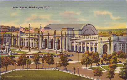
Union Station, DC
Surface mobility at train stations in Germany. I have only been to three German cities, Essen, Hamburg, and very briefly, Dortmund. In each city, the train station is at the center, and the stations open onto a pedestrianized very active and bustling center.
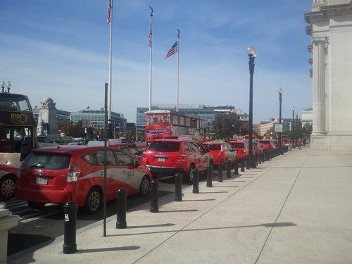
More in Dortmund and Hamburg than Essen, they separate tourist bus services from regular transit services, putting them on different sides of the station. See that, as well as the Denver underground bus concourse, has influenced my thinking about this in terms of the potential for Union Station, as well as the reality that vehicle capacity in front of Union Station is already maxed out and creates major conflicts between pedestrians walking out from the station and the motor vehicles hogging the space in front of the station.
Federal Railroad Administration guidance. From the FRA publication Station Area Planning for High-Speed and Intercity Passenger Rail:
2. TRANSPORTATION: Maximize Station Connections with Other Transportation Modes
� Region and City: Diagram and map existing and potential connectivity among intercity rail, regional
commuter rail, and public transit networks. Also overlay bike networks.
� Station area:
� Map street networks; pedestrian and bike networks; public transit stops and stations; taxi and
kiss-n-ride areas; and parking spaces. Categorize streets and develop design criteria for each type
including the width allocated to peds, bikes, transit, autos and trucks, and the separation given to the
various uses through curbs, medians, curb parking, trees, etc.
� Document existing and proposed percentages of rail station patrons by type of access — transit, walk,
bike, taxi, kiss-n-ride, and park-n-ride.
� Evaluate distances and elevation changes required to transfer; also ticketing and signage.
Apply Universal Design principles to accommodate all people.
� Reduce parking demand through such policies as cash-out of employer-paid parking, transit pass
and ride-share programs.
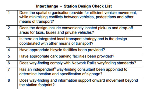
Network Rail (UK) guidance. From Guide to station planning and design:
6.5 Intermodal exchange and wayfinding
The designer is expected to ensure that journeys are as seamless as possible. The station design has to take into account that passengers do not start and end
their journey in a station. Their travel experience is very much determined by their approach and departure from the station. Depending on location this can be any
combination of the following forms of transport:
Walking
Cycling
Car drop off or taxi
Bus or tram
Car parked in station car park
Underground railway
Airports
Boat
The station has to cater to the requirements of all the above customer groups and accessibility is of prime importance. Interchange between all modes must be efficient and obvious to the traveller with clear signage, minimum changes of level and where possible protected from the elements.
Labels: land use planning, railroads, real estate development, station area planning, transportation infrastructure, transportation planning, urban design/placemaking
posted by Richard Layman @ 5:34 PM&Permanent Link
![]()
![]()


5 Comments:
In terms of union station, I think they tend to underestimate pedestrian usage.
If you remember, they did a good job on the streetcar signage. Not such a good job on Circulator ? I only discovered it goes into the garage by accident.
You don't need dedicated taxi lanes anymore. Or at least plan to phase them out. Having a "cell phone waiting area" would help.
The pedestrian element at Union Station is a mess, especially pedestrians crossing the traffic lanes to get to the Capitol Complex.
Plus the need to treat the intersections as a system, have some pedestrian scrambles, etc.
The local transit service isn't the greatest either, on Massachusetts and from H Street it's almost nonexistent.
I understand theoretically why the Circ. is up in the intercity bus service area, to reduce the distance to a bus, but as much as I push transit, if you have a lot of luggage (and people in your party), you're going to take a cab. Especially because transit wayfinding information is weak.
Because of that I don't agree with you about taxi service. A need for it will always be there. Plus if the ride hailing services continue to exist, you can incorporate them into the program.
WRT pedestrian integration generally, I guess because it's mostly just with Eastern cities, Chicago, now maybe Denver, plus San Diego, and maybe LA, that you have train stations with a lot of pedestrian based access, that our guidance and integration is mixed.
The Network Rail guidance is straightforward, not particularly complex. Likely because the people who access stations there in most cities are likely to be on foot.
Here, outside of the legacy cities, most people are likely to access train stations by car, and to some extent, by local transit.
Any examples that we should look to that come to mind from your travels?
RE: Taxi.
Correct on the luggage issue, but as the distinction between uber/taxis/my dropping someone off lessens those curbside lanes shoudl be reserved for that -- not just for licensed taxis.
Right now they have two of them, and they just really need one.
Not sure if the "bike station" near the metro is really being used.
Note: the Circulator does not use the bus garage for passenger convenience, it uses the bus garage as a layover location.
1. WRT bikes I will be making that point about the bike station. It doesn't provide that much capacity and it was misconceived probably, in terms of providing bike access for presumably MARC and VRE users. But I don't think that many of those users use an owned bike for the remainder of their trip.
Plus now there is bike share, and MARC is retrofitting cars so that they will be able to provide bike storage on all trains (well maybe not the Camden Line, they said they are retrofitting bi-level cars, and I don't think bi-level cars run on that line).
I haven't been to any train station in the US that does a particularly good job with high quality bike parking. Ideally an underground kiosk system could be provided.
2. Alex B. thank you for the clarification. One thing about the bus on Mass Ave. is that its stop is just before "the service drive" (I am not sure what street that is technically,) where it impinges on the traffic lanes and creates congestion.
I have to do a "visual" survey of the blocks around for my comments. Ideally, I'd put in a lay by (talk about major problems with HP review) in the Plaza on the Mass. Ave. curb lane to accommodate westbound local bus service. Not sure if there is enough space to not impinge on the fountain, etc.
Post a Comment
<< Home