Rebuilding Place in the Urban Space

"A community’s physical form, rather than its land uses, is its most intrinsic and enduring characteristic." [Katz, EPA] This blog focuses on place and placemaking and all that makes it work--historic preservation, urban design, transportation, asset-based community development, arts & cultural development, commercial district revitalization, tourism & destination development, and quality of life advocacy--along with doses of civic engagement and good governance watchdogging.

Friday, May 29, 2020

D.C. cuts speed limit to 20 mph to curb pedestrian deaths: a step forward but not enough | New thoughts on a comprehensive Vision Zero agenda

Neighborhood Slow Zone street sign, 4th and C Streets SE, Capitol Hill, Washington, D.C.
Neighborhood Slow Zone street sign, 4th and C Streets SE, Capitol Hill, Washington, D.C. I haven't seen such a sign elsewhere in the city. I don't know if it was a pilot case.


Today, DC announced that starting next week, the prevailing speed limit -- unless posted otherwise -- will be 20mph ("D.C. cuts speed limit to 20 mph to curb pedestrian deaths," Washington Post. 

Currently, the prevailing speed is 25mph, and the posted speed is often 30 mph on major arterials, especially as you move outside of the core.

Interesting.

Years ago, when then Councilmember Bowser and Councilmember Wells suggested that the prevailing speed be 15mph, I said that was too slow, that 20mph would make sense, especially for residential streets.

-- "A more radical approach to Vision Zero," 2019
-- "A reminder about how the entitlement of automobility is embedded into law and democratizes death by accident," 2014
-- "A "Vision Zero" agenda for DC," 2014
-- "DC and Vision Zero Revisited," 2015
-- "Updating Vision Zero approaches," 2016
-- First global benchmark for road safety in cities published by International Transport Forum," 2018
-- "Pedestrian fatalities and street design," 2019

In "Updating Vision Zero approaches" I reorganized the recommendations into categories modeled after the "6 E's" of bike and pedestrian planning, but with some modifications:

-- Planning/Placemaking
-- Engineering and Maintenance
-- Education
-- Encouragement
-- Enforcement/Traffic Engineering
-- Equity

(The Sustainable Mobility Platform concept I've been developing includes pedestrian elements.  It needs an update too.)

Now they're doing it.  Except according to the article Mayor Bowser hasn't given up on 15mph:
Bowser also announced a “slow streets” initiative through which some neighborhood roads will be restricted to local traffic only and have a posted 15 mph speed limit. The District Department of Transportation is identifying locations, Bowser said.
I have some concerns about this, especially in the core of the city, because the strength of the mobility network is the grid of blocks and streets, and if the grid gets more disconnected, this can have other negative elements.

Similarly, I've suggested that signage about the city's prevailing speed limit, which is lower than the surrounding suburbs, should be posted at entry points to the city, especially main arterials like Wisconsin, Connecticut, Georgia, and Rhode Island Avenues, 16th Street, East Capitol and South Capitol Streets, etc.

Given the new directive, it's worth listing the recommendations from the "Enforcement/Traffic Engineering" element:

Enforcement/Traffic Engineering
In this section I've added traffic engineering as an element slightly different from the kinds of infrastructure facilities typically covered under the "Engineering" E.


NYC Vision Zero ad. Suburban residents often don't realize that it is inappropriate to drive fast in urban environments.

26.  Put signage up at the major entry points into the city, stating that the prevailing speed limit is 25 mph, unless posted otherwise.

27,  Make residential street speed limits 20 mph.

28,  Change the speed limit around transit stations to 25 mph (or 20 mph).

29,  Post notification signs at locations of traffic deaths.

Image from Streetsblog.

30. Change the legal framework with regard to motor vehicle operation to require that automobiles--as the heaviest and most powerful mobility device--should be accorded the greatest amount of legal responsibility with regard to traffic accidents.

31. Up the penalties for vehicle accidents that injure, maim, or kill, regardless of intent.

32.. Retrain police officers with regard to bike and pedestrian accident analysis so that their default position is not "the pedestrian/the bicyclist is automatically at fault."

33. Legalize the Idaho Stop for bicycling.

34. Consider the development of a bicycle operators endorsement for drivers licenses.

35. Bring back the traffic enforcement division of the police department as a special unit. (Note that the Motor Carrier Safety Unit still exists, although it's probably a federal requirement.)

36. Give parking enforcement officers the training and legal authority to ticket driving infractions.

37.  Advocate to the Consumer Product Safety Commission for the inclusion as original equipment front and back lighting, and left and right turn signals on bicycles intended for urban transportation use

I guess with this change by the city, I should go back and do a re-read of the Vision Zero agenda and update it.  Certainly if the city can change the speed limit, it can legalize the Idaho Stop.

Here are two items on my mind.

Big data and targeted traffic safety initiatives.  In comments on one of the entries, charlie made that point that the big issue is really addressing in a systematic way the people who are likely to be the worst/most dangerous drivers.

While I have been derisive of "big data" approaches at times, figuring that the "gee whiz" element of big data is used when regular but systematic techniques are capable of similar "revelations," it's just that no one is focused on transformational practice, focused efforts on dangerous drivers is a big opportunity for big data ("Real-Time Data Analytics Aims to Reduce Traffic Fatalities," Government Technology).

Treating sections of streets as networks, and addressing intersections as nodes within the pedestrian network.  I have been meaning to write a piece about intersections as networks.

I have written about it here and there ("Barnes Dance Intersections as possible "solutions" to Wisconsin & M, 14th and U intersections," 2016) but now I am thinking about it more comprehensively, including the addition of mid-block crosswalks where needed (L'Enfant's plan for the city's streets made some blocks double and triple the size of a normal block).

I made the point in my writings on Silver Spring, Maryland, as point #4 in this entry, "PL #5: Creating a Silver Spring "Sustainable Mobility District" | Part 2: Program items 1 - 9."

Create a network of pedestrian scramble intersections, where one designated signal phase is exclusively for pedestrians: on Colesville Road at East-West Highway, Second Street, Georgia Avenue, and Fenton Street; on Fenton Street at Ellsworth, Wayne Avenue, and Bonifant Street; and at the intersection of Wayne and Georgia Avenues.  And a more defined crosswalk treatment should be provided at the mid-block crossing at Ellsworth and Georgia Avenues, crossing east-west.
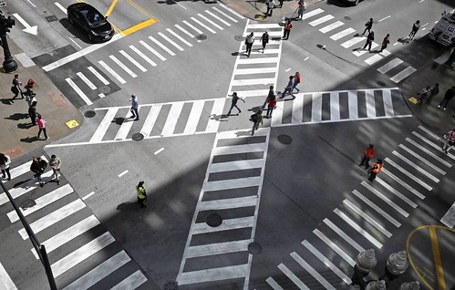
Pedestrian scramble, Jackson Boulevard and State Street, Chicago
Pedestrian scramble, Jackson Boulevard and State Street, Chicago. Photo: John J. Kim, Chicago Tribune.

While the road network prioritizes motor vehicle throughput, some places have far more pedestrian traffic than motor vehicle traffic.  One way to better balance movement for pedestrians is to provide a "pedestrian scramble" or "Barnes Dance" intersection treatment where one phase, including diagonal crossing, is exclusively for pedestrians.

Back when Downtown DC was the region's primary shopping and office district, DC had multiple such intersections.  More recently, one was created at 7th and H Streets NW and one is being installed at 14th and Irving Streets NW.  I have argued that DC needs multiple such intersections as a traffic safety and mobility rebalancing intervention ("Barnes Dance intersections as possible solutions").

There is also a mid-block pedestrian crossing on Georgia Avenue at Ellsworth (which doesn't continue west across Georgia Avenue) which needs a more defined crossing treatment comparable to markings for the street crossings on the Indianapolis Cultural Trail.
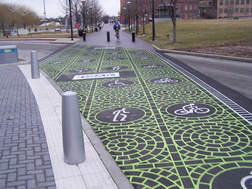
Street crossing, Indianapolis Cultural Trail
The ICT is marked by high quality markings at street crossings, making very clear the prioritization of non-motorized mobility.

This should be added to the Vision Zero comprehensive agenda as an additional element within the section on Engineering.

For example, all of the crosswalks from:
  • the 200 block to the 1500 block of Pennsylvania Avenue SE
  • on H Street NE from the 300 block to the Maryland Avenue intersection, and continuing from that point on Benning Road NE to Oklahoma Avenue NE
  • on 14th Street NW from Thomas Circle to Spring Street at the edge of Columbia Heights
  • and so forth -- e.g., Connecticut Avenue, M Street, Wisconsin Avenue, Georgia Avenue, etc.
should be treated as single networks, have special design treatments, etc.

The failure to think this way is a major omission in city transportation planning in DC and elsewhere.

Another place I've suggested this is in Takoma DC on Cedar Street from where it terminates at Piney Branch Road at the Takoma Elementary School to Old Town Takoma Park.

But there are dozens of places across the city with similar conditions and opportunities.

=========
Also see:

-- "Activists block off DC streets to create socially distant outdoor space," WTOP radio
-- "Boston 'Healthy Streets' program to include bike lanes, bus stop expansion, outdoor dining," WCVB-TV
-- Boston Healthy Streets program

Labels: , , , , ,

Friday, September 30, 2016

Right hook cyclist deaths and a couple tweaks to my ideal Vision Zero agenda

A bicycle is seen underneath the Tomlinson construction truck that collided with a cyclist on Thursday morning. (CBC photo.) The cyclist, Nusrat Jahan, was the 23-year-old daughter of a diplomat and a student at Willis College.


In September, bicyclists were killed in Ottawa, Ontario and Chicago as a result of trucks turning right and running over cyclists.

What killed them is called the "right hook" in bicycle safety planning.  It's where a truck turning right hits a cyclist, who is usually present in a "blind spot."

Many if not most cyclist deaths in cities are the result of crashes with trucks and other "heavy vehicles" like buses.
Data on bicycle crashes from the UK
Data on truck-related traffic deaths in 19 UK cities.   Graphic by Brigade Electronics, manufacturer of truck camera/vision systems.

This reminded me of various initiatives in London under both Mayor Livingstone and Mayor Johnson. Initiatives including Johnson's the Safer Lorry Scheme, have introduced a number of measures to reduce the likelihood of cyclist death from crashes with lorries.

One of those measures is what are called "safety guards" on the sides of trucks, to prevent cyclists from being crushed by truck wheels ("Cameras on lorries to cut toll of cycle deaths," London Times).
Truck side guards to prevent bicycle deaths
St-Laurent mayor Alan DeSouza and Jeannette Holman-Price attend a news look at a truck side guard on Tuesday, May 8, 2012, after the borough announced details of new safety devices on trucks. Montreal Gazette photo.

In the DC area, most transit systems have special training for bus drivers addressing pedestrian and bicyclist safety.  DC government's truck drivers (transportation, public works, water department) have gone through the same training.

The coverage of the deaths in the Ottawa Citizen ("Diplomat's daughter victim in deadly truck-bicycle collision," "Safety audit along Laurier Avenue gets underway in wake of cyclist death," and "Reevely: The first step to safe streets is really wanting them" ) and the Chicago Tribune ("Woman struck, killed while riding bike in Roscoe Village -- 5th death of bicyclist this year," "Chicago: bike-friendly but how bike-safe?," "Six bicyclists killed in Chicago this year, all involving commercial vehicles") is important because it includes calls for improved infrastructure and other measures.

There is some irony to the deaths in Chicago because Chicago was just named by Bicycling Magazine as the nation's best city for biking in their annual survey and cover story.

Interestingly, one column in the Citizen ("Cycling dangers mount alongside our growing urban core") suggests that the creation of separated bicycle lanes may create a sense of complacency on the part of bicyclists when it comes safety, which can be problematic when the infrastructure is sub-standard. From the article:
But I’ve come to worry – no, it’s worse than worry, as the skipped heartbeats attest – that segregated lanes and other inducements to pedal around downtown Ottawa are giving cyclists a false sense of security as they boldly slip in and out of the daily rush of inner-city traffic. ...

We should be asking, though, whether incidents like this, which seem to occur in Ottawa now with alarming frequency, and which follow a pretty clear pattern – rush-hour collisions, heavily travelled streets, tight-turn intersections – are not better described as predictable tragedies.
Because Ottawa is the national capital, the local accident has led to calls for the national government to pay closer attention to the issue ("Amid war of words, MP seeks national safe-cycling strategy" and "Feds launch task force on cycling and pedestrian safety") something that used to happen with regard to DC-based events and Congress, but now no longer does, as Congress is increasingly disconnected from addressing issues substantively in most of the issue areas where federal involvement can make a difference. From the latter article:
Gareth Davies, president of the Ottawa advocacy group Citizens for Safe Cycling, said he’s “pleasantly surprised” by the momentum in the past week to make safety initiatives a priority.

“It’s good to see the feds doing something,” Davies said.

Transport Minister Marc Garneau announced that the task force will consider cameras, side guards and awareness programs as measures to prevent collisions and reduce injuries and deaths.

Transport Canada will complement the task force’s work by studying technologies to reduce collisions.
Safety improvements for heavy goods vehicles/lorries/trucks, UK
Bicycle-related safety improvements for heavy goods vehicles/lorries/trucks, UK

Shockingly compared to the US, the Ottawa truck driver has been charged with serious crimes in association with the crash, where the penalties are as serious as life in prison ("Truck driver charged in Laurier crash that killed cyclist Nusrat Jahan," Citizen). From the article:
Steven Bruce Conley, 38, was charged Friday with criminal negligence causing death and dangerous driving causing death.  The dangerous driving charge carries a maximum 14-year sentence upon conviction, while a conviction on criminal negligence causing death can carry a life sentence.
By comparison in the US rarely are drivers significantly penalized for traffic accidents resulting in death--unless they are under the influence of alcohol or drugs, or sometimes, in very rare situations of extreme negligence ("Driver to plead guilty to River Road crash that killed 3," WTOP radio).

In the entry "Improvement must be constant," Ottawa's West Side Action blog makes a very good point, that just as we constantly improve the quality of the road infrastructure for motor vehicles, as new infrastructure treatments are developed, we need to do the same for biking, and generally we don't.

In a DC example, more recently, DC's department of transportation has been clarifying bike and motor vehicle movement at intersections, by marking "pocket lanes" for cyclists ("These two new short bike lanes, called "pocket lanes," help traffic flow and keep cyclists safe," Greater Greater Washington).

I've never been to Ottawa, but comments on news articles and blogs indicate that the implementation of the Laurier Avenue cycletrack was suboptimal (hence West Side Action's call for improvements). Note that Toole Design created a best practice guide for cycletracks for the State of Massachusetts, with guidance that is universal.

-- Separated Bike Lane Planning & Design Guide, MassDOT Highway

It was only after advocacy by the London Cycling Campaign that Transport for London improved the design for "Cycle Superhighways," from merely painted lanes to separated lanes ("What did Boris ever do for cycling?").


As enumerated in "Updating vision zero approaches," I aver that the list of 39 items is pretty complete.  But I think that adding side guards and cameras to trucks should be added to the section on enforcement and traffic safety engineering.  The items are organized into six categories:

- Planning/Placemaking
- Engineering and Maintenance
- Education
- Encouragement
- Enforcement/Traffic Safety Engineering
- Equity

Also, while point 27 asserts that neighborhood streets should be reposted for a 20 mph speed, as is being done in leading cities concerned with rebalancing motor vehicle and placemaking goals, in the interim before such a standard is legislated, it should be standard practice to reduce the speed on streets that are "neighborhood bikeways" to 20 mph, in advance of the general change.

Neighborhood bikeway signage in DC, note the 25 mph speed limit.

Note that earlier this week, Seattle City Council passed legislation to lower speed limits there, including 20 mph for neighborhood streets, and 25 mph for arterials ("Seattle to get lower speed limits" and "Seattle City Council considers lowering speed limits all over the city," Seattle Times).

In the reporting, some argued against the change, finding that tests of lower speed limits in Seattle didn't result in marked changes.

But I would counter that a pilot test on a handful of streets, not a widespread change accompanied by marketing and enforcement of the changes, people's "behavior" with regard to speed won't change.

Furthermore, we don't need to prove changes through pilot tests in each community considering such changes, we can rely on general findings from changes in communities elsewhere

-- "Speed limit reduction in urban areas: a before-after study," Accident Analysis and Prevention
-- "The impact of lowered speed limits in urban and metropolitan areas," Monash University Accident Research Center
======
One other point to add to the section on enforcement and traffic safety engineering that I can't believe I forgot, making front and back lights mandatory equipment on "city/hybrid" type bikes sold for primarily urban use.  (And turn signals.)

For example, my criticism of the new Ikea bike, despite its improvements such as belt drive "chain," is that it targets the urban rider but doesn't include lights as "original equipment."

The Breezer Uptown bicycle includes front and rear lights (pictured at left).

Labels: , , , ,

Thursday, January 28, 2016

Barnes Dance Intersections as possible "solutions" to Wisconsin & M, 14th and U intersections

Last week, the Current ran a story, "City studies dangerous intersections," about DC's five most "accident prone" intersections.

Because the Current covers the northwest quadrant of the city, the article focused on only two of the five intersections, Wisconsin Avenue and M Street NW--the "100% intersection" in Georgetown, and 14th and U Streets NW, a major crossroads intersection for its neighborhood.

According to the report High Crash Intersection Site Visits, produced at the prodding of Councilmember Mary Cheh, who chairs the Council committee with oversight over transportation matters, the other intersections are 1st Street and Massachusetts Avenue NE, at Union Station, Minnesota Avenue and Benning Road NE, and New York Avenue and Bladensburg Road NE.  (The primary problem at the latter two intersections are motor vehicle crashes.)

The two northwest quadrant intersections are major nodes in the bus transit network too serving Metrobus and DC Circulator routes, and Georgetown's sidewalks are particularly narrow for the amount of pedestrian traffic they carry.
Wisconsin Avenue and M Street NW intersection, Georgetown, DC

Wisconsin Avenue and M Street NW intersection, Georgetown.  Getty Images photo.

14th and U Street NW intersection, DC
14th and U Streets NW.  Photo by Two Coffee Cups Consulting.

These particular intersections are major nodes in the city's pedestrian network, but because of the high motor vehicle traffic, signal timing favors motor vehicle movement over pedestrians.  The traffic signal settings are complicated with multiple cycles, and some where pedestrians may cross against the light, bollixing vehicle traffic.

Note that from observation I'd say that besides high pedestrian volumes for both, the major problem in Georgetown is that not enough time is allocated for pedestrian crossing, while at 14th and U, during the left turn phase from 14th Street NW pedestrians cross against the light.

The so called "Barnes Dance" or "pedestrian scramble" intersection is set up to devote one entire cycle in the signal series exclusively to pedestrians, and allows for crossing the intersection six ways--on each side of the box and diagonally.

To its credit the DDOT report suggests considering "Barnes Dance" intersection as an intervention worth considering for the two intersections.  Interestingly, the Current article didn't mention the pedestrian scramble as an option for either intersection.

According to research ("The Relative Effectiveness of Pedestrian Safety Countermeasures at Urban Intersections — Lessons from a New York City Experience ") introduction of the pedestrian scramble intersection treatment has been associated with a 50% reduction in pedestrian-involved crashes.

DC has one intersection set up this way, at 7th and H Streets NW in Gallery Place/Chinatown ("D.C. tests new diagonal pedestrian crossing downtown," Washington Examiner).

But that intersection, in my opinion, doesn't have a special enough urban design treatment to denote its uniqueness.

This video by Andrew Bossi was made during the initial test phase, but the street markings aren't much different even today.
2010 05 14 - 5825 - Washington DC - 7th & H - Barnes Dance Barn Dance

Barnes Dance intersections in other cities, such as Pasadena, do a better job with pavements and street markings that denote a rebalancing of street usage towards pedestrians.

If DC is to implement more pedestrian scramble intersections, the ante should be upped on the quality of the street markings so the intersections stand out as special nodes within the mobility network.
Pedestrian scramble intersection, Colorado Boulevard, Pasadena, California
Note how this "pedestrian scramble" intersection at Colorado and Raymond Avenues in Pasadena has special faux brick treatments for each of the pedestrian pathways, including the two diagonal paths.  Photo: Gina Ferazzi, Los Angeles Times.

Pedestrian scramble, Jackson Boulevard and State Street, Chicago
Pedestrian scramble, Jackson Boulevard and State Street, Chicago.  The intersection serves about 41,000 pedestrians and 21,000 vehicles each day.  Photo: John J. Kim, Chicago Tribune.

Converting these two intersections to Barnes Dance--pedestrian scramble--intersections would go a long way towards better balancing pedestrian level of service with motor vehicle level of service and likely lead to a significant reduction in pedestrian-motor vehicle accidentscrashes.

==============
Treating 1st and Massachusetts NE and North Capitol and Massachusetts in combination.  The primary problem at 1st and Massachusetts NE is lack of adequate time provided to pedestrian crossing--Barnes Dance doesn't work for that intersection because pedestrians are moving primarily across only two of the four sides to the intersection (across 1st Street to and from Union Station and across Massachusetts Avenue).  Although the report did note some other complications.

I'd argue that the evaluation of this intersection fails in some respects, by not evaluating 1st and Massachusetts Avenue NE in concert with an evaluation of the intersection one block west, North Capitol Street and Massachusetts Avenue.

Problems at 1st Street are exacerbated by the queuing of motor vehicle traffic moving westbound on Massachusetts.  Eliminating parking in the curb lane would facilitate motor vehicle (and bicycle) movement and likely reduce some of the driving stress that may contribute to accidents at 1st Street.

Furthermore, walking is uncomfortable on the south side of the block between North Capitol and 1st Street because the sidewalk width is inadequate and people also queue for buses in this space. Similarly, the sidewalk on east side of North Capitol next to the Post Office building up to G Street is exceptionally narrow considering the volume of pedestrian traffic and the placement of a bus stop on this block.

While not the right treatment for 1st Street, a Barnes Dance intersection ought to be considered for the North Capitol and Massachusetts intersection, which has issues similar to the 14th and U with signal cycles, exacerbated by narrow sidewalks relative to the pedestrian volume in some locations. (Interestingly, I complained to USPS about particularly narrow sidewalks on the North Capitol side of their building in 1992.)

 Large pedestrian volumes crossing North Capitol lead to significant queuing of traffic waiting to turn right. But the exclusive right turn signal phase is made less efficient by pedestrians crossing North Capitol.  But there are large volumes of pedestrians crossing Massachusetts Avenue as well.  While all four sides of the intersection don't experience equal volume, a Barnes Dance intersection treatment still probably makes sense and should be considered.

Labels: , , , ,