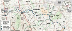
Speaking of the Purple Line
It's been a couple days since the presentation at the Brookings Institution (see "Greening The Suburbs" for another report), and I have been mulling over my response. Maryland's Secretary of Transportation John Porcari was great. Montgomery County Councilmember Marc Elrich was surprisingly troubling, and Chris Leinberger was Chris Leinberger, tautly focused on urbanism and the link to transportation, development economics, and investment.
Porcari pointed out many problems with the Federal funding system for local transit projects:
(1) the agency focuses on saying no so they don't have to come up with funding--this is called the New Starts process, but many call it the "No Starts" process;
(2) it only focuses on the cost to open, not the cost to maintain, and fails to take into account decisionmaking that should support a system built to survive for more than 100 years (he made a good point about short term thinking for the DC area subway system and how that constrains capacity today or increases costs, and can't be undone without spending billions and billions of dollars, or how a bus lasts 10-15 years but a subway car up to 40 years, and how each bus needs a driver, etc.). In other words the FTA scoring system doesn't focus on the lifecycle cost of the system. Over time, fixed rail is cheaper, and has higher ridership, and lasts longer.
(3) the ridership projection method is very conservative;
(4) not to mention that the scoring system doesn't take into account very much other factors such as economic development and livability.
This is important because Councilmember Elrich figures that the Environmental Impact Statement for the Purple Line says that the high cost light rail scenario will only generate a little more ridership than the high cost bus rapid transit system, but cost 1/2, and that by going with bus, you could build the other transit system that Montgomery County wants, the Corridor Cities Transitway.
Another thing discussed some in the back and forth of the session is "bus rapid transit." BRT works great in dedicated systems in places where passengers are willing to tolerate extremely high "crush loads" and with relatively low personnel costs. In other words, BRT works great in South America.
BRT supports road building, so the highway lobby isn't against it. But the reality is that in the U.S., people won't tolerate the bus loads that they have in Latin America. In other words, at most you might have 80-90 people on a 60 foot articulated bus in DC, but in Curitiba, Bogota, or Santiago, it's twice that.
Plus, bus infrastructure, at least in the U.S. doesn't generate the kind of transit adjacent development that occurs with rail transit. The likely reality is that over time, rail ridership will grow significantly, and bus transit will not. As Leinberger pointed out, middle class people don't like riding buses. If you want to get people out of their cars, a bus-based transit system won't do it. By providing rail-based solutions, we provide a better transit system for everyone, especially those who are transit-dependent, and make automobile diversion far more likely.
Now, Elrich and others mentioned the Euclid Avenue BRT Corridor in Cleveland, which is getting some transit adjacent investment. But that really is a special case. That is the main old business corridor in the city and it has been the backbone of reinvestment in Downtown for about 20 years (Theater District, Jacobs Field, Cleveland State University, dozens and dozens of building conversions for housing). The BRT isn't a cause of a lot of this. (Just like MCI Center isn't the only reason that the Central Business District is moving east in DC, it's also because of the dissipation of land inventory suitable for development in the old core of the Downtown.)
The only real bus rapid transit I've ridden in the U.S. is in Pittsburgh (I saw the Wilshire BRT route in Los Angeles but didn't get a chance to ride it). It's awesome. From East Liberty to Downtown, on a dedicated busway (former streetcar right of way) it flies. But there is little argument that this busway system has generated little significant transit-adjacent investment over the more than 25 years Pittsburgh BRT has been in existence. (And the investment occuring in East Liberty today is a result mostly of the lack of any developable land inventory in the very successful and adjacent Shadyside district.)
BRT is promoted by the Federal Transit Administration because they don't want to pay for fixed-rail systems. End of story. (More about an aspect of this in the next blog entry.)
I know this is long already but I had three major reactions in response to both Elrich and Leinberger.
1. My elucidation of the concept of the regional transit network as a set of subnetworks doesn't seem to shape how elected and appointed officials and other stakeholders think about transit in their localities and in the region. (My concept extends the one laid out by Arlington County within their Master Transportation Plan.)
See "The DC Transit Network." I am really gonna have to write a journal article about this.
2. Relatedly then, creating the Purple Line is the beginning of refiguring next generation transit within MoCo and PG, not the end point. Just as Montgomery County reshaped the RideOn bus system to provide service to subway stations from neighborhoods, the transit system within the county will have to be reshaped in response to the addition of the light rail system.
Part of the way to do this kind of planning is through my transitshed-mobilityshed concept ("Updating the mobilityshed concept") which is more expansive in thinking than the mobility hub concept. (Another journal article topic.)
In October 2006, I made a presentation to the Action Committee for Transit on thinking about next generation transit in Montgomery County. I guess I will put it up on slideshare over the weekend. I only gave it once (but I significantly expanded and revised it after the meeting).
For example, speaking of rethinking, DC and Takoma Park could create a streetcar line (this idea was sparked in part by Ken F.) from Walter Reed to Takoma Metro and beyond Takoma Metro out Carroll to the station at University Boulevard and down the light rail line (streetcars and light rail can be interoperable) to the Langley Crossroads Purple Line Station and back up New Hampshire Avenue. This will link all of Takoma's commercial districts and provide direct rail service to the federal campus at Walter Reed, link Columbia Union College, etc.
And speaking of more things to do, you have to create Transportation Management Districts, Transportation Demand Management, and multiple mode planning NOW (bike station at Langley Crossroads? and one should have been put in maybe at PG Plaza Metro..., etc.), not after the Purple Line opens! Then the system will be adequately leveraged and car trips reduced.
3. The ability to capture the value of transit adjacency is fully dependent on urban design and intensity of land use. One comment that Councilmember Elrich made is (paraphrased) "if transit is so great for economic development, why do the areas around most subway stations in PG County suck?"
The answer isn't that complicated. It has to do with the structure of land use. You can say the same within DC or Montgomery County, depending on your definition of "suck" (a word that Mr. Elrch did not use).
For example, Dupont Circle vs. Van Ness vs. Fort Totten vs. Union Station in DC shows that small blocks, a variety of building sizes, mixed uses, walking-based communities have much better success integrating and leveraging the value of transit.
Leinberger called the Green Line the next Red Line in terms of its impact. I don't agree with him fully because most of the stations do not have Walking City-Transit City era urban design, which makes it difficult to leverage the value of the transit. Even Petworth is tough beyond the immediate area around the Metro station, because the blocks are long and the intensity of residential development is relatively low. Fort Totten really shows this. And then by building stuff that looks so junky, it's not likely to change.
Takoma is an interesting contrast to Fort Totten. While some of the infill residential construction looks great and some doesn't, there is already an albeit small commercial core, some restaurants and other amenities exist and more are coming as residential density increases. But for the most part, the Greater Takoma area has an urban form more conducive to walking and transit. It's not perfect, but it's better than Fort Totten, and this will only increase over time.
But PG, other than further intensity of land use at the PG Plaza station, hasn't been able to leverage the value of transit because the stations are mostly placed in areas where they are disconnected from other uses, especially residential, not connected to it, and they don't evince "urban" design, but suburban, car-centric land use planning.
Anyway, Leinberger says that in advance of opening a transit system, you should have station area plans, covering 100-300 acres around the station, allowing for more intensive development. For the most part, I agree with him, but I think that examples thus far demonstrate the necessity of a fine grained urban design program for these station area plans.
Labels: mixed use, sustainable land use and resource planning, transit oriented development, transportation planning
posted by Richard Layman @ 10:51 AM&Permanent Link
![]()
![]()


0 Comments:
Post a Comment
<< Home