One of the many reasons I haven't been blogging is that
on Monday and Tuesday I participated in the Dutch ThinkBike workshop, which looked at two areas of DC, L and M Streets NW and the SE-SW Waterfront/Capitol Riverfront District. I was in the L&M Street group and in fact, in the M Street subgroup.
The teams were led by some Dutch experts from the
Fiets Beraad, the Dutch Bicycle Council with the involvement of the Embassy of the Netherlands. Local participants included planners and professionals mostly with a smattering of advocates from not just DC, but from Maryland and Virginia as well as the Federal Government.
Different groups of Dutch experts do sets of workshops, so our program was not led by the people who did the other workshops. There was some back and forth "tension" about our charge, what we could learn from the Dutch group and how to leverage their expertise (as well as our own), and how to frame what we were doing.
I didn't want what we did to be too constrained, although we were very much constrained by time, because these types of workshops are seen by others as the be all and end all and if stuff is excluded, that ends up inadequately shaping future opportunities. Eventually people agreed to my point that this particular effort on L and M should be considered exemplary but part of a broader network of cycle tracks.
E.g., we ended up suggesting that cycle track treatment of the Avenues such as Massachusetts Avenue and Connecticut Avenue are particularly important, the upgrading of the bike lane on E Street NW to a cycle track, etc.
What I'd say we learned from the Dutch is to think "bigger" and "bolder." The two points about thinking bigger that our group grasped were:
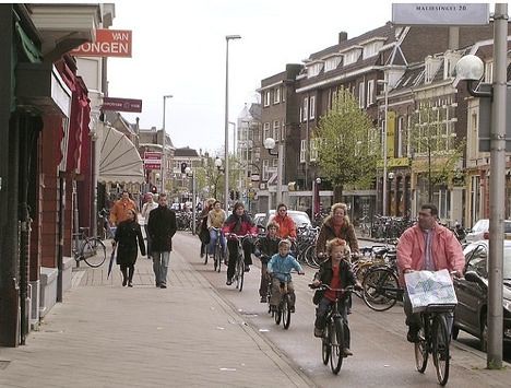
(1) going with a bi-directional cycle track on both streets, rather than uni-directional. And of a robust construction -- median separated, protected by traffic, etc. They did have some issues with our streets, because compared to the Netherlands, DC streets are much wider. And they integrate cycle tracks into the right of way much different than we do. They do it between the road and the sidewalk. Typically in the U.S. it is in the street, but with a median separation.
Dutch Bike Lanes.
They had a number of great resources which I coveted, but didn't swipe:
- and individual brochures on the biking planning environment in different towns.
The advantage of uni-directional is that you don't have the kinds of turning and signalization issues that come from contraflow traffic. But as the Dutch continually pointed out "bicyclists are like water -- they flow where it's simplest for them to do so" and as has been proven by the initial experience with the 15th Street contraflow cycle track, where cyclists rode in two directions on the track, even though it was supposed to be southbound only, it's better to make cycle tracks bi-directional.
Our team leader was very surprised that Washington, DC doesn't have any areas in the core of the city that are exclusively pedestrian (and bicyclist) and wildly successful. (I explained that we had some pedestrian malls here and there in the city over the decades but that they tended to be problematic for a variety of reasons.)
Dutch woonerf or "living zone"

One of the difficulties of doing shared spaces in the U.S. (actually whenever an advocate mentions this, I get scared sh**less) is that the Dutch don't privilege motor vehicles the same way that they are in the U.S.
First, it's much more difficult and expensive to get a driver's license. Second, the cost and difficulty of getting a parking permit in the center city is much harder--it takes three years. Third, and most important, driving laws make motor vehicle drivers responsible for all accidents involving pedestrians and bicyclists as a matter of course, regardless of actual fault--because motor vehicles are so much bigger and faster, drivers are required to engage in extranormal levels of caution and responsibility compared to the U.S. Not to mention things like high excise taxes for both gasoline and car purchases.
Pedestrianized street space in the 32nd Street area of Manhattan.

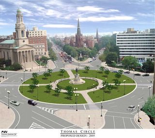
But New York City shows us a way forward, not to mention earlier city efforts such as the restoration of Thomas Circle to its original dimensions--it had been carved up by traffic lanes over the decade.
Rendering, Thomas Circle reconstruction.
So what the L&M group recommended, in a nutshell:
1. Robust cycle tracks, bi-directional, on L and M Streets;
2. Branding these tracks or bikeways the "Crosstown Connector" or "Crosstown Bikeway" because serendipitously, we figured out that by having a cycle track from M Street at the Metropolitan Branch Trail going west on M Street to and through Georgetown up to the Key Bridge that we could connect a number of off-road trails including the Metropolitan Branch Trail, the Rock Creek Trail, the Capital Crescent Trail, the C&O Canal Trail, and by providing connections to Key Bridge and Arlington County, the Mount Vernon Trail and the Custis Trail in Virginia.
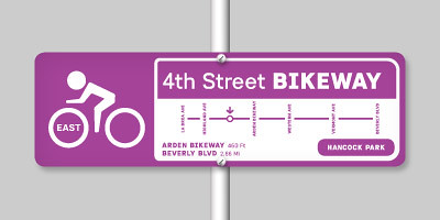
We meant to include in our presentation an example of a wayfinding sign like the one below, as a branded sign element, but in the press of time, we forgot.
Image from the
Better Bikeway Signage website. (DDOT prefers using the standard green bicycle route signage rather than the creation of a branded bikeway signage system. I prefer the latter.)
3. With regard to extending the qualities of livability, we recommended making the intersections at the Avenues such as Connecticut Avenue, New Hampshire Avenue, and Pennsylvania Avenue grander, along the lines of the New York examples we are more familiar with; and
4. Treating M Street between 22nd Street to Rock Creek Park (around 26th Street) with more "home zone" like treatments such as asphalt block and improved streetscape conditions.
5. Plus, we recommended that DC emphasize more greatly that the posted speed limits are in fact 25 mph on most every street in the core of the city, and on most of the streets in the city, more along the lines of the European slower speed initiatives (30 kph and 40 kph or 50 kph initiatives started in Graz, Austria in the early 1990s and are continuing to spread across the continent). It's not that we don't know the speed limit is "only" 25 mph, it's that many drivers don't know or act like that is the speed limit. (Plus, because so many streets are so wide and engineered and constructed for higher speeds, drivers are "encouraged" to speed.)
General lesson:
1. Bicycle professionals and advocates need to get together more, around the region, and do these kinds of workshops and mix people up while we're doing it. (The same goes for transit and pedestrian professionals and advocates as well.)
That was mentioned by Jim Sebastian, director of the DC bicycle, pedestrian, and transportation demand management program in his closing remarks. But we all saw the value of it before. And this had nothing to do with the "Dutch experts" per se.
We don't get together often enough, we don't mix up the type of people and expertise and experiences of the participants in planning exercises enough, so often we miss out on good ideas and opportunities.
For example, it was a total fluke that we figured out that an M Street cycletrack across the northwest quadrant could connect up 6 different multi-use trails. The current program for L and M Street, designed at 50%, didn't figure it out. But by going over the maps, and knowing about the various trails, looking at the maps, and being willing to extend the boundaries of our consideration _beyond the formal scope of our project_ which technically was from 15th Street to Pennsylvania Avenue along L and M Streets, and we extended the area we were considering from the Met Branch Trail to and through Georgetown (although we didn't really provide suggested design treatments for the areas east of 15th Street and on M Street from 26th Street to the Key Bridge).
Ideally, this kind of experience should be conducted once/year, and rotate between DC, Maryland, and Virginia. I'd say it should be a little longer, although two days is a long time, it still wasn't enough to refine a bunch of the ideas.
This would build up and extend the capacity and expertise of advocates and professionals across the region, and build inter-jurisdictional connections that may not exist otherwise.
Labels: bicycling, car culture and automobility, change-innovation-transformation, civic engagement, design method, transportation planning, urban design/placemaking


1 Comments:
Thank you for providing such a valuable information and thanks for sharing this matter.
Post a Comment
<< Home