Manhattan Institute misses the point about the value of light rail transit connections to airports | Utility and the network effect: the transit network as a platform
======
Republished from Wednesday 5/13/2020, with a new date because of additional quotes from the Salt Lake Tribune article and additional text.
======

Recently, the Manhattan Institute released a report, THE ECONOMICS OF URBAN LIGHT RAIL: A Guide for Planners and Citizens, making the point that in "new" transit systems, specifically light rail systems, airport connections don't make economic sense in terms of generating enough increased ridership to pay for the cost of the extension ("New study pans airport rail lines in Utah, Denver, Dallas as pricey boondoggles," Salt Lake Tribune).
From the SLT article:
A new study says light rail lines to airports may be popular politically, but they don’t make sense economically. Exhibit A: The Utah Transit Authority’s Green Line TRAX to the Salt Lake City International Airport.This is about land use not transit. The study is more about light rail and finds that in most cases, Bus Rapid Transit makes more economic sense. From the article:
“The extension receives middling ridership, even by the standards of a light rail system with generally poor performance,” says the study by the Manhattan Institute, a conservative think tank whose mission is to “develop ideas that foster greater economic choice and individual responsibility.”
The TRAX extension from downtown Salt Lake City to the airport cost $350 million when it was completed in 2013. The study says that money could be better spent elsewhere, especially on buses.
Study author Connor Harris looked at 23 light rail systems in the nation to come up with recommendations about where and when such systems make sense, and when they should be avoided. His main conclusion is that bus rapid transit systems — such as the new Utah Valley Express in Provo and Orem — are usually smarter, cheaper, more flexible and work better overall than light rail.But the comparative failure of rail in the cities they studied comes down the fact that in places with "new" transit systems, the automobile is still the dominant form of transportation.
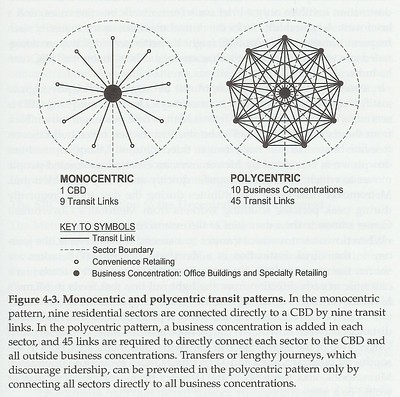
The addition of transit, especially without a strong network and a polycentric transit and land use development form (see the discussion about the difference between monocentric and polycentric transit systems in Cities in Full by Steve Belmont) isn't enough to change a city or metropolitan area's land use and transportation planning paradigm in significant ways away from the automobile.
It can take a long time for higher density transit oriented development to make sense economically ("Transit planning in Baltimore County"), although it can be accelerated with advanced planning ("Light rail housing fund spurs 15 projects in metro Phoenix" (2014) and "Why you don't see more vacant lots along light-rail route," (2015), Arizona Republic), but too frequently polycentric places aren't focused on density ("South Salt Lake's housing boom driven by its transit lines," Salt Lake Tribune), so the return on investment takes even longer.

Many airport trips don't lend themselves to transit. The report acknowledges that airports are usually far from the core of a metropolitan area and in places with limited residential development (for obvious reasons, airport noise is a nuisance, "Buyer information and the hedonic: The impact of a seller disclosure on the implicit price for airport noise," Journal of Urban Economics 63:2 [2008]). From the SLT article:
The study highlights what it says are common errors with light rail systems, including “overvaluing certain classes of destinations such as airports.”It's also complicated by the nature of airport trips: (1) a proportion of large groups, and transit costs don't scale for larger groups (it's cheaper to drive); (2) bulky and a lot of luggage (making it more convenient to drive, but parking can be expensive); and (3) automobile parking is a significant revenue source for most airports, which can discourage an airport's promotion of transit.
Airport lines “tend to perform poorly” because they are remote from population centers, require extensive construction and their routes tend not to serve many people or dense developments along the way, the study said.
Airport trips by residents versus visitors. In polycentric places like Denver, Salt Lake, or Dallas, transit trips to and from airports are likely to be predominately by visitors, whereas in dense places with more monocentric urban form, rich transit systems and efficient connections to airports, both residents and visitors are likely to use transit for airport trips.
Past blog entries on airport transit issues include:
-- "Airport transportation demand management in flux," 2019
-- "Transportation demand management, transit: Los Angeles Airport (LAX) and Logan Airport, Boston," 2019
-- "London's Stansted Airport provides digital information on transit options," 2019
-- "A brief comment on ground transportation at National Airport vis a vis VRE rail service," 2016
-- "Revisiting stories: ground transportation at airports (DCA/Logan)," 2017
-- "Airports and public transit access: O'Hare Airport and the proposed fast connection from Downtown Chicago," 2018
-- "More on airport-related transit/transit for visitors," 2013
Airport transit connections are about maximizing the utility of the transit system: Network breadth. But it's also more complicated in another sense, beyond the specifics of ridership and economic payoff.
It's about what I call "network breadth" and "network depth." Breadth is about maximizing the geographic footprint of service, while depth concerns frequency and ridership.
Being able to get to more places makes the transit system more useful and leads to overall ridership increases. Although the report is derisive of this according to the article:
Still, “it’s easier to form a broad political coalition for airport service than for run-of-the-mill transit improvements,” it said. “City power brokers like to impress out-of-town visitors with airports, and suburban residents who do not use transit regularly imagine that a train for their occasional airport trips would be convenient.”It's comparable to my discussion about the difference between intra-city or intra-district transit and inter-city transit. Each has different conditions and benefits and needs to be evaluated on the appropriate framework, rather than criticizing the form and mode because it doesn't perform the function of the other.
-- "Making the case for intra-city (vs. inter-city) transit planning," 2011
-- "Modern streetcars are transportation projects,not merely economic development augurs: but intra-district not inter-city services," 2017
In this case, you want a transit network to provide service to the major activity centers and traffic "generators" in a metropolitan area. An airport is a key destination in a metropolitan area and you want it to be served by the transit network.
While the line to the airport may not "pay off" economically it makes the entire system more useful contributing to higher ridership overall.
Postal system as an example of the value of cross-subsidy and the "network effect." Another way to think about it is like the Postal system. It costs more to serve some customers than others.
But cross-subsidies between users allow for everyone to be served economically, in the belief that everyone benefits from having a complete network affordable to all. This is the public good/social good argument.
But cross-subsidies between users allow for everyone to be served economically, in the belief that everyone benefits from having a complete network affordable to all. This is the public good/social good argument.
This is also about what is called "the network effect." "Metcalfe's Law" as outlined by the computer networking pioneer Bob Metcalfe focuses on the value of network increasing from the number of users, but it's about users and what they can connect to both. The more users and the greater number of connections make the system more useful.
From "There is Power in Numbers: Network Effects and Metcalfe’s Law":
In the economics literature, a network effect typically refers to a change in the positive benefit that a consumer receives from a good, when the number of consumers of the good increases. Liebowitz and Margolis (1994). Network effects are not limited to phone, wireless, and telecommunications networks. They can also include the following:
- Transportation networks such as roads, railroads, and flight paths.
- Communication systems such as the postal service, express mail services, and pony express.
- Communication media such as books, printed materials, schools, and universities, because they disseminate ideas and knowledge and those ideas have greater utility.
- Social networks involving a social structure between individuals or organizations with similar interests. They include political, cultural, religious, sports clubs, social clubs, volunteer groups, family, friends, industry trade groups, and market segments. Facebook, Twitter, and Web 2.0 social-networking applications.
It's about the value of transit as a platform. More recently, with the rise of IT "platforms," originally Microsoft Windows at the scale of the individual computer, or now Facebook, enabled by the web browser and the Internet, people are inclined to think about this in terms of platforms ("Understanding the basics of Network Effects — The Power of the Platform").
I call this the Sustainable Mobility Platform. In this case, connecting to the airport, makes transit as a platform more useful.
Reed's Law posits that a network's value is twice that of the number of nodes ("The Network Laws," Network Effects Bible).

The more nodes and in particular the more nodes of importance that a transit system serves, the more useful is the network, which makes it more competitive with the automobile.
The same is true of roads ("Network effect of transportation infrastructure: a dynamic panel evidence," Annals of Regional Science [2013]). Not every road is revenue positive, in terms of use and road taxes paid ("Do Roads Pay for Themselves?," Texas DOT, 2006, out of print). But each road (hopefully) extends the usefulness and value of the road network as a whole. From the article:
Until recently, when TxDOT built or expanded a road, no methodology existed to determine the extent to which this work would be paid off through revenues.Airports can be distant from city centers. Utility is complicated by the fact that increasingly, airports are located at a distance from city centers, making the transit trip long, especially by light rail, which is slower than heavy rail (subway) and railroad service. Although close-in airports, such as Salt Lake City can be pretty convenient even by slower light rail service.
The Asset Value Index, was developed to compare the full 40-year life-cycle costs to the revenues attributable to a given road corridor or section. The shorthand version calculates how much gasoline is consumed on a roadway and how much gas tax revenue that generates.
The Asset Value Index is the ratio of the total expected revenues divided by the total expected costs. If the ratio is 0.60, the road will produce revenues to meet 60 percent of its costs; it would be “paid for” only if the ratio were 1.00, when the revenues met 100 percent of costs. Another way of describing this is to do a “tax gap” analysis, which shows how much the state fuel tax would have to be on that given corridor for the ratio for revenues to match costs.
Applying this methodology, revealed that no road pays for itself in gas taxes and fees. For example, in Houston, the 15 miles of SH 99 from I-10 to US 290 will cost $1 billion to build and maintain over its lifetime, while only generating $162 million in gas taxes. That gives a tax gap ratio of .16, which means that the real gas tax rate people would need to pay on this segment of road to completely pay for it would be $2.22 per gallon.
| City | Distance to Downtown | mode | Time |
|---|---|---|---|
| Atlanta | 12 miles | heavy | 22 minutes |
| Baltimore to Baltimore | 11 miles | light | 30 minutes |
| Baltimore to Baltimore | 12 miles | railroad | 10 minutes |
| Baltimore to DC | 33 miles | railroad | 35 minutes |
| Chicago Midway | 11 miles | heavy | 29 minutes |
| Chicago O'Hare | 12 miles | heavy | 45 minutes |
| Cleveland | 14 miles | heavy | 50 minutes |
| Dallas | 25 miles | light | 50 minutes |
| DC National Airport | 5 miles | heavy | 15 minutes |
| DC Dulles | 27 miles | heavy | 52 minutes* |
| Philadelphia | 12 miles | railroad | 24 minutes |
| Phoenix | 3 miles | light | 29 minutes |
| Portland, Oregon | 9 miles | light | 62 minutes |
| Salt Lake City | 7 miles | light | 20 minutes |
| San Francisco | 15 miles | heavy | 30 minutes |
| Seattle | 15 miles | light | 40 minutes |
Note these times don't include the time to get from the transit station to the airport terminal. This can be significant, depending on the distance to the terminal(s) and the quality of ground transportation integration.
* The Silver Line extension to Washington Dulles Airport will open in 2021.
In the DC area, residents can choose between three airports. DC National is closest to DC, but if airplane travel cost is the primary issue, people may prefer BWI Airport, which does have a train connection, but takes longer to reach. But given the savings this may be an acceptable tradeoff.
National is served by DC subway, but not railroad, while BWI is served by the local light rail system and the regional railroad system, making that airport more reachable from a larger geographic area. (Washington National Airport has the potential for better railroad connections, especially if VRE and MARC were to merge. See "A new backbone for the regional transit system: merging the MARC Penn and VRE Fredericksburg Lines.")
Similarly, it takes a long time to get to Dulles Airport and currently does not have a direct rail transit connection (bus services make the final connection), so that in terms of travel time to and from the airport, people are more likely to choose either National or Baltimore.
Chicago has two airports both accessible by heavy rail at the same cost and and similar amount of trip time, depending on the origin point, although O'Hare also has some railroad connectivity, although it isn't particularly efficient and convenient.
Of course, many areas only have one airport, making this question moot.
Premium express train service. Note that this is a separate issue from premium express services from international airports such as London (Heathrow), Paris (Orly), and in Tokyo ("A Guide to Tokyo's Airport Access Lines," Japan Railway Journal, NHK World).
The highest volume airports with a large number of well-off users can support special, more expensive premium transit services, while lower volume airports such as Toronto, cannot ("How Toronto Turned an Airport Rail Failure Into a Commuter Asset," CityLab).
 Bus service. And from high quality branded bus services, which may not necessarily be fast but can be convenient and legible, such as the Logan Express bus system in Boston or the 747 Airport bus in Montreal ("STM ‘destroying’ 747 shuttle with cuts, airport claims," Montreal Gazette).
While increasingly de-emphasized, the Metrobus 5A service to Dulles Airport and the B30 service to BWI were noteworthy in that the buses have luggage racks, which is atypical for local transit service to airports.

Interior of the WMATA Metrobus B30 bus to BWI Airport from Greenbelt Metro Station. (A trip is double the cost of a typical bus ride, although there is a significant discount when transferring from another bus or subway.)
* The Silver Line extension to Washington Dulles Airport will open in 2021.
Airport connections to transit as a decision element. That LaGuardia Airport in Queens doesn't have a direct subway connection is problematic, making the rail transit system less useful, but also making use of LaGuardia Airport less useful. Some people, if they have a choice, will choose to use an airport that is more directly accessible by transit, like Newark.
In the DC area, residents can choose between three airports. DC National is closest to DC, but if airplane travel cost is the primary issue, people may prefer BWI Airport, which does have a train connection, but takes longer to reach. But given the savings this may be an acceptable tradeoff.
National is served by DC subway, but not railroad, while BWI is served by the local light rail system and the regional railroad system, making that airport more reachable from a larger geographic area. (Washington National Airport has the potential for better railroad connections, especially if VRE and MARC were to merge. See "A new backbone for the regional transit system: merging the MARC Penn and VRE Fredericksburg Lines.")
Similarly, it takes a long time to get to Dulles Airport and currently does not have a direct rail transit connection (bus services make the final connection), so that in terms of travel time to and from the airport, people are more likely to choose either National or Baltimore.
Chicago has two airports both accessible by heavy rail at the same cost and and similar amount of trip time, depending on the origin point, although O'Hare also has some railroad connectivity, although it isn't particularly efficient and convenient.
Of course, many areas only have one airport, making this question moot.
Premium express train service. Note that this is a separate issue from premium express services from international airports such as London (Heathrow), Paris (Orly), and in Tokyo ("A Guide to Tokyo's Airport Access Lines," Japan Railway Journal, NHK World).
The highest volume airports with a large number of well-off users can support special, more expensive premium transit services, while lower volume airports such as Toronto, cannot ("How Toronto Turned an Airport Rail Failure Into a Commuter Asset," CityLab).

While increasingly de-emphasized, the Metrobus 5A service to Dulles Airport and the B30 service to BWI were noteworthy in that the buses have luggage racks, which is atypical for local transit service to airports.
Interior of the WMATA Metrobus B30 bus to BWI Airport from Greenbelt Metro Station. (A trip is double the cost of a typical bus ride, although there is a significant discount when transferring from another bus or subway.)
Labels: airports, fixed rail transit service, sustainable land use and resource planning, sustainable mobility platform, transportation demand management, transportation planning, visitor services
posted by Richard Layman @ 3:42 AM&Permanent Link
![]()
![]()


15 Comments:
"Resist the urge to start small"
https://pedestrianobservations.com/2020/05/12/resist-the-urge-to-start-small/
Yes was going to send that link.
Americans used to think in systems; no doubt having our brightest minds either chase down pennies in finance or pennies in online advertising hasn't helped.
But why the real reluctance to think in systems?
I saw this in telecom years ago; if you remember when GSM was going to be the range (1995) and the FCC did not want to adopt a european system. Lots of industry pressure (Qualcomm) but also a real desire to just go "unlicensed" and do it in part 15.
(Once qualcomm became the standard LTE, I didn't see any system reluctance).
If you told me it was just Koch money for the past 30 years killing transit I'd agree -- but you can see with "dockless bikeshare", uber etc there is a real reluctance to embrace systems.
Levy's point (Americans are massively provincial, only a few have seen a functioning transit system, and that is at a tourist not as a planner) is correct but I think misses deeper answers.
First, the technology thing can be provincial. But also wacked libertarian viewpoints.
I still remember during the Reagan Administration the failure to develop AM Stereo. There were multiple formats competing and the government "didn't want to pick a winner; let competition do it."
But the thing about platforms and systems that just doesn't work.
The result was that AM Stereo never developed.
cf. VHS vs. Beta
The challenge is to not do it badly (pick a format that is crippled).
In a similar way this is what the problem is with e-scooters.
Although it's not the format/design/technology, but just too many f*ing entrants for it to make sense for anyone.
Although this article pisses me off
https://www.theverge.com/2020/5/13/21257307/electric-scooter-bikeshare-covid-19-bird-lime-uber-subsidies
talking about providing city subsidies to scooter providers.
Rather than doing that, I'd just integrate scooters into bike share systems and cut out the for profit providers.
Is there a really compelling reason for a firm like Bird or Lime to be doing this instead of a locality?
wrt Alon's piece, he knows a lot more about operations than I do.
But similarly I've been in an argument with Gerry Niely of Balt. I wanted to write a series of pieces with him about what a transit agenda should be for Baltimore.
But he is hung up on Baltimore is relevant only as part of the NE Corridor, that the local leadership is f*ed up so focusing on the local/regional is a lost cause, etc.
You've got to look at all this in parallel.
Speaking of systems, it's the whole basis of my "framework for metropolitan mass transit planning" about multiple scales and transit networks and subnetworks.
I'm sure academics have written along these lines, but in the blogosphere you don't see this kind of thinking. (E.g., like my intra-city vs. inter-city, etc.)
My thinking about HSR now is that while it's the right thing to do theoretically, it's such a big jump from our pathetic state of passenger rail state, that what Obama should have done is focused on investing in making regional systems much better, with parallel investment in cross-regional service from Amtrak.
Of course, it's a version of the VV, at larger scales.
I've mentioned watching Japan Railway Journal on NHK World.
So I've learned about how privatization worked there with the breakup of the national railway. There are now 6 "divisions", some are fully privatized. Some are public because they have to be subsidized. Then there are local rail systems, some private some public, somewhat like how the VVs work.
They integrate, complement, extend, and even compete with the JRs, depending.
So last summer I started writing what will be a three part series about rearticulating rail service in the US, based in part on what I've learned about Japan, VVs, roots in my comments on the DC State Rail Plan, etc.
But this gets back to the fact that we used to have an integrated railroad passenger system. It's recreating part of that, but also recognizing developments and changes in the last 60 years.
One of the keys in that series is the idea to bring back National Train Day, which Amtrak did for a few years, which is in May because that's the anniversary of the Golden Spike, to a Train Month, and extending it from Amtrak to include the regional railroad systems and even the freight railroads if they are interested, AAR, APTA, etc.
----
But then Suzanne accelerated our move and everything, and I didn't finish it.
But the JR part is "break up" the US into say 6 rail planning districts, and organize at the national, multistate, state, and regional scales within each district, and the national linkages as a backbone across all the districts.
Set it up like a VV.
There are plenty of examples in the US of initiatives already that would fit into this. Like in Virginia, California, Maine, the Cascades (OR, WA, BC), plus advocacy pushes about improving regional rail systems like in MA or NY or Chicago. My writings on DC-MD-VA. CT-MA-RI and expansions in both directions. How NJT, MN, and LIRR should be integrated. Etc.
Anyway, and within that framework, do the kinds of things that Alon says should be done.
Eg., with HSR, just doing the SE corridor from say Atlanta to DC. And making the NE corridor better.
Again, systems.
I found this book at an estate sale on Capitol Hill...
https://sciencepolicy.colorado.edu/students/envs_5110/bijker.pdf
It mentions the development of electricity delivery systems as being different in different countries. I never tracked down some of the key work it mentioned.
https://www.nap.edu/read/23394/chapter/19#111
In the early 1990s I was involved with some of this stuff on IT, telecommunications, the web, and television (but our business was undercapitalized). The whole telecommunications thing is very interesting as platforms.
Like with Uber and Lyft, or all the scooters, as you probably well know, in the early days there were competitors to Bell, but over time most of those companies were absorbed.
the much larger rail cars help even more than usual for rail vs. bus for the airport, tho right (of course)? with luggage and what not. plus trying to hold your luggage on a bumpy ass bus ride... i'm good on all that.
If you haven't read any of the things on Platform Thinking, you probably would be interested https://medium.com/platform-innovation-kit/how-platform-thinking-transforms-business-society-and-work-ecbf988703c8
Or from own colleague at work https://www.thoughtworks.com/insights/blog/art-platform-thinking
Thank you for these cities. Will get to them.
FWIW, I was ahead of the curve on platform thinking in the early 1990s, when I worked at CSPI, and tried to get them to reposition the Nutrition Wizard software analysis program as a platform. I had the idea to license cookbooks and magazine annuals to integrate into the program.
And I have thought long and hard about Windows as a platform. And of course since.
Vienna, express train, subway, and bus. The bus line is branded with a nice livery: Vienna Airport Lines.
https://www.welcomepickups.com/vienna/airport-transfer-to-city/
Another thing about Alon's post and bigger scales, bigger systems.
A line between Cleveland and Cincinnati in Ohio isn't that useful if it's not part of a larger network. Regardless if it's fast or slow.
[No different than my comparison of the DC area having a transit network with six lines and Baltimore having a single truncated subway line and a industrial oriented LR line, which are poorly connected.
Having the network of different modes working at different scales, but integrated, makes a huge difference.]
This was the point, again that I was making with the guy in Baltimore.
I call it getting to and from a place and within a place, in this case cities and metropolitan areas and regions (which I define as two or more metropolitan areas.)
Yes, you can get between those two places, but without a deeper and broader transit network (set of subnetworks), you can't get anywhere else except to and from.
And then I don't think you're going to bother with transit.
Interestingly, if you look at car-related ephemera from the 1940s and 1950s, you had two different things going on.
In what Muller calls the "recreational auto era" you had maps, postcards and ads promoting travel, using your car.
On the other hand, Hertz advertised their rental cars in association with train trips. So you wouldn't put lots of mile on your car. Take the train long distance from your home to Washington, then rent a car at Union Station (etc.).
=====
Obviously, in a place like Germany, you have regional rail (including faster service) and then well developed multi-mode metropolitan scale transit networks. E.g., I took the train from the Dusseldorf Airport to Essen and then Essen had lots of transit (which I didn't do because I was part of a study group and we got ferried around).
But then I took the regional train to Hamburg and then used the metropolitan transit--bus, S Bahn railroad, and subway--to get around the city.
I don't know the UK obviously. Liverpool and London have similar set ups. But in Liverpool chaotic bus service but still better probably than most other jurisdictions outside London (chaotic because of privatization and disallowance of unified systems outside of London).
Liverpool basically has an S-Bahn but it's set up to provide heavy rail like service. But the city is connected to others via regional and longer distance rail.
(As I said, as bad as the UK rail system might be compared to Continental Europe, it's light years ahead of the US.)
Speaking of lack of a network, NC DOT just suspended rail service between Raleigh and Charlotte. There were 3 round trips per day, but two had already been cancelled.
It's easy to cancel a line. Hard to cancel a network.
https://www.masstransitmag.com/rail/news/21138084/nc-ncdot-suspends-piedmont-train-service-between-raleigh-and-charlotte-to-save-money
And the point that Alon made, about railfans being ok with substandard service is relevant.
Basically I'd extend it to "railfans are happy with a rail line" but "regular transit users and transit systems are best served by a robust transit network."
Edinburgh Airlink branded bus:
https://terrysbusphotos.smugmug.com/BusChassisTypes/Volvo-Buses/Volvo-B9TL/L/Lothian-Buses/Volvo-B9TL/i-bkWGXSv/A
Even in a Sunbelt city, depending on the purpose of the visit, you can possibly get by staying only downtown and getting around on foot or by local transit/taxis (I'm thinking meetings and conventions in the CBD, forget anything on the fringes).
However, inadequate transit from the airport to the CBD pushes people to the rental car, and at that point, the visitor can stay and patronize any region of the metropolitan area they choose (CBD, chain hotel off the interstate etc.)
CBD improvement districts thus have an incentive to make attractive transit from airport to CBD - you often see it in the form of a "premium"-branded bus service, but I don't think that would cut it except for some of the most hardcore transit advocates.
WTOP radio article on holiday usage via Silver Line of Dulles Airport, 9% of trips. We need to have this kind of TDM information more generally, for all trips.
https://wtop.com/dc-transit/2023/01/data-9-of-travelers-used-silver-line-to-dulles-international-airport/
"Just how many holiday travelers used Silver Line to Dulles International Airport"
An airports authority official said about 15% of travelers currently use Metro’s blue and yellow lines at Reagan National Airport.
======
Need plans to increase the percentage. Although as I have said, it's a pain to carry luggage.
Brightline rail in South Florida has a superb program to get people to and from the station at the beginning/end of their trip.
https://www.gobrightline.com/mobility
Post a Comment
<< Home