Rebuilding Place in the Urban Space

"A community’s physical form, rather than its land uses, is its most intrinsic and enduring characteristic." [Katz, EPA] This blog focuses on place and placemaking and all that makes it work--historic preservation, urban design, transportation, asset-based community development, arts & cultural development, commercial district revitalization, tourism & destination development, and quality of life advocacy--along with doses of civic engagement and good governance watchdogging.

Thursday, July 12, 2012

("You") Made the cover of Transportation Research News

I have not been a fan necessarily of the Pennsylvania Avenue NW in-the-middle-of-the-street cycletrack, not because it doesn't work, and it is getting used more, but because it was done in a place that most bicyclists don't really use, although with the US Capitol in the background, it's a very visible and prominent pro-bicycling piece of infrastructure.
May-June 2012 Transportation Research News with cover photo of Pennsyvlania Avenue NW cycletrack, taken by me

But on Bike to Work Day on Friday May 18th, 2012, you wouldn't have known that  the lanes are often lightly used, because with all the people going to and from one of the pit stops at the Ronald Reagan International Trade Center (it was supposed to be on Freedom Plaza I think), the lane was packed.

Maybe not to the point where you'd think DC is Copenhagen or Amsterdam, but we made a fair showing nonetheless.

I took a bunch of photos, including one that made the cover of the May-June issue of Transportation Research News, which focuses on Active Transportation (walking and biking).

The reality is that cycletracks do make a big difference.

At the right time of day, use of the 15th Street NW cycletrack makes me believe that DC, at least in the core of the city, has the potential to significantly increase mode share of bicycling for all trips, upwards of 20%.

Labels: ,

Sunday, February 12, 2012

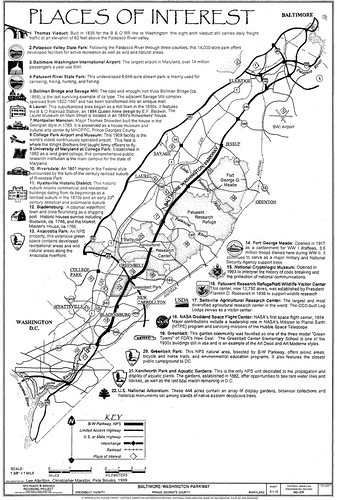
Baltimore-Washington Parkway Widening Feasibility Study

I haven't seen any recent articles about this process in the local media (Gazette newspapers, Washington Post, etc.) but happened on an online ad on the process.

Apparently there were stories in the PG County Sentinel, "Baltimore-Washington Parkway widening study underway," and the Greenbelt Patch, "If You Widen It, More Will Come: Opposition to widening Parkway remains palpable among — at least some — Greenbelters," in July, on the first meeting, at Fort Meade in Anne Arundel, County.

According to the Patch article, about 40 people attended the first meeting. The Examiner also wrote about the study in January 2011, "Plan to widen BW Parkway concerns local officials."

- History of the Parkway, from DC Roads
- Parkways (Wikipedia)
- Evolution of Parkways, Historic Roads in the National Park System, NPS

Description of the purpose of the BW Parkway from the NPS website:

A Gateway to our Nation's Capital
Enjoy the scenic entryway into our Nation's Capital. Opened in 1954, the parkway is a 29-mile scenic highway that connects Baltimore, Maryland with Washington, D.C.

The parkway is a part of four parkways that welcome visitors and integrate a design to convey to citizens the importance of the capital city. The NPS manages the parkway from the D.C. boundary to Fort Meade, Maryland.


The study was supposed to be finished last month, but there is a public meeting, the third, scheduled for this week:

February 16, 2012
6:30pm to 8:30 pm
Greenbelt Community Center
15 Crescent Road
Greenbelt, MD 20770

The study examines "the feasibility of adding a third northbound and a third southbound land to the BWI Parkway between the interchange wtih I-695 in Anne Arundel County Maryland, and New York Avenue in the Distict of Columbia."

According to the website:

The study is the result of legislative language included in Fiscal Year 2010 Appropriations legislation sponsored by Congressman C. A. Dutch Ruppersberger, Maryland District 2, directing the FHWA to work with the National Park Service (NPS) and the Maryland State Highway Administration (SHA) to determine the feasibility of such a widening. The study will include an assessment of the impact of the Base Realignment and Closure (BRAC) process on traffic throughout the Maryland Route 295 corridor between Baltimore, MD and Washington, DC.

Interestingly, the Congressman who initiated the study is from Baltimore County, while much of the impact from a widening project would be in the DC region. While the B-W Parkway doesn't enter DC per se, it is a key north-south "freeway" -- a "parkway" actually, so that it is supposed to be park-like rather than concrete-like.

It connects to DC via Route 50 (New York Avenue).

In any case, the study should consider adding a continuous bikeway as part of any widening project, even though my predilection might be for no widening. Note that the State of Connecticut is studying adding a continuous trail to the Merritt Parkway ("Walking the Merritt Parkway: ConnDOT considers a multi-use trail," Trumbull Patch).

-- Merritt Parkway Trail Study website, Connecticut DOT

It is a little known fact that bikeways can be included in FHWA-funded "freeway"/Interstate projects, it depends on the policies of the local state. Maryland happens to not integrate bikeways into Interstate projects generally, although there are instances of bridge crossings for trails and walkways, mostly in the DC area, with the Wilson Bridge, and crossing the Beltway next to Georgia Avenue in association with the Forest Glen subway station. The City of Rockville has also created walk-bike bridges over I-270.

And there is an award-winning project that was integrated into I-70 in Colorado that is a national model that should have been transmitted to all states as a best practice example of what could be achieved.

-- "Glenwood Canyon, 12 Years Later," Public Roads Magazine, FHWA

1. Note that it is projects like these--biking and pedestrian integration projects--that are to be eliminated from funding in the proposed Federal Transportation Bill (see "" by Neal Peirce)

2. Although the basic point really is that a complete transportation demand management program should have been created with regard to the transportation impact of BRAC-related base relocations to Fort Meade and the Aberdeen Proving Ground in Maryland, with a focus on minimizing the generation of new trips.

Only in that context should a widening of BW Parkway be considered.

3. Also, while the Baltimore-Washington Parkway is not an Olmsted creation, obviously the idea of parkways came out of his work. Preservation and planning efforts in Louisville and Buffalo, which culminated in parkways management plans for those communities are obvious models for how to treat the Washington area parkway "system", which includes the GW Parkway in Virginia, and the Suitland and the Rock Creek and Potomac Parkways in Maryland, in addition to the BW Parkway.

-- Understanding and Managing Historic Park Roads, Historic Roads in the National Park System, NPS
Baltimore-Washington_Parkway

Labels: , ,

Friday, November 04, 2011

WABA regional call to action conference

Regional Call to Action Summit, Washington Area Bicyclist Association
I am jumping the gun a little bit, because WABA--the Washington Area Bicyclist Association--hasn't quite yet posted its take on yesterday's conference, including uploading the pdf of their third "Call to the Action" (the first was in 1972, when the organization was formed, the second in 2000, after years of neglecting bike infrastructure in DC).

Even though I would have organized yesterday's conference differently, with mostly different topics focused on "regional" biking issues, I still learned something from every presentation.

1. Planning for Healthy Communities
-- I was reintroduced to the concept of Health Impact Assessments as a technique for promoting healthy, active outcomes as part of urban planning, site planning, and development decision making.
-- this model, from San Francisco, is one that we could use locally

2. Bicyclists in crashes
-- when you are in a crash, and people ask you if you're all right, always respond, "I don't know" because you don't, and because physical problems usually take awhile to manifest
Capital Bikeshare
3. "Bikesharing"
-- this session featured presentations by three people, Eric Gilliland, general manager of the Capital Bikeshare program, Darren Buck, a student at Virginia Tech doing research on Capital Bikeshare and bike infrastructure, and Professor Ralph Buehler (who works with John Pucher) of the Virginia Tech urban planning program in Alexandria, Virginia.

-- while most of the questions were for Eric, I was especially intrigued by work that Prof. Buehler is doing on the nature of biking in the Washington region, and how the demographics and results compare to other regions, and that separately there will be eight presenters from around the world as part of a TRB conference workshop at the annual conference in January.

-- Darren had some interesting visual presentation of data on links between car ownership, presence of bicycle infrastructure, density, and presence of shopping destinations and bike sharing use.

I wish that the operations part of bikesharing would have been in a different session, so that more time could have been given to Prof. Buehler and related findings. Those papers should be available in December.

4. WMATA and bicycle accommodations
-- WMATA is doing a lot more. They've replaced all their old racks with 1700 inverted U racks, they are building a protected and secure bike parking facility at College Park, and are planning to do so at Franconia-Springfield, they would like to have protected parking at 56 of their 60 stations where they own the land. They have completed various other improvements for pedestrian access as well.
-- They have moved parking management functions for biking into the Parking Operations Department and are developing stronger information systems for bike lockers and other programs to better accommodate biking.
-- (I didn't know that) As long as transportation enhancement funding exists, WMATA is required to spend 1% of the funds they receive from the Federal Government on enhancements such as biking and pedestrian improvements, and while they cannot fund everything that they would like to do, this is a steady source of funding for bike improvements, so long as the enhancement program continues to exist.
-- they see that improvements for biking often are improvements for disability access.

5. Bike shops and Advocacy
-- while I wouldn't claim that I got actionable information from this session, a number of the presenters made good points

CALL TO ACTION SESSION
Shane Farthing, Regional Call to Action Summit, Washington Area Bicyclist Association
Shane Farthing, Executive Director, WABA.

I hate to put this last because this was the most important, but it was last on the conference agenda.

Shane Farthing, the executive director of WABA, made an EXCELLENT presentation, far far far exceeding my own expectations for what they were going to come up with.

In preparation for the conference, WABA held sessions in each of the jurisdictions. For the most part, they felt that people mostly focused on micro issues--e.g., markings on a particular street, etc.--and not the big issues.
Local meeting results, Regional Call to Action Summit, Washington Area Bicyclist Association
Issues expressed at the various local meetings and captured in a word cloud measurement graphical rendition.

Shane decided it was the responsibility of WABA to think really big, to lay out a vision of a truly bikecentric environment, where biking (such as in those places where the conditions support it, such as in DC, Alexandria, Arlington and other conurbations--this is my list not theirs) can truly be a significant mode, reaching and meeting the needs of the 60% of the U.S. population that says they are interested in biking, but aren't, because they aren't comfortable riding in mixed traffic/high speed traffic situations.

The focus is not just what in active transportation planning are called the 5 E's (engineering, education, encouragement, enforcement, and evaluation) but a 6th E for equity, all based on placemaking and quality of life.

Resources
-- National Household Travel Survey results, 51% of all trips are 3 miles or less (League of American Bicyclists blog post)
-- Roger Geller research, 60% of population willing to bike for transportation but isn't currently ("Portland's Bicycle Brilliance," The Tyee)
-- Transportation equity webpage, Victoria Transport Policy Institute

Business consultant and author Jim Collins would call this a "Big Hairy Audacious Goal."

He didn't lay out a mode split goal --for me in the city it would be at least 20% of all trips.

It was an inspiring presentation. Sure, it echoes things I've been thinking and writing for the last couple years, but I can hardly take credit for it.

I was really proud of WABA at that moment, that they could step out of the day-to-day, and think much bigger. That focusing on "adding one more bike rack" wasn't the point.

Another thing that I am really proud of them for doing is looking at what the organization does and what it should do and how to best use their (limited) resources.

I always get into a debate with people about direct service vs. focusing on bringing about long term, structural change.

Doing Bike to Work Day, as long as it is focused on the day as an event, and not as an event focused on harvesting the people and the energy as a fulcrum of potential change at the worksite, ends up absorbing significant amounts of resources, and while great for community building, doesn't contribute that much to long term change objectives.

So effective in 2012, the Downtown Business Improvement District is taking over the management and staging of the Freedom Plaza Bike to Work Day event, which is the biggest and best true, but now WABA, which face it, has limited resources, can do more and better and other things...

Labels: , , , ,

Tuesday, October 18, 2011

Police department community safety ride on DC Metropolitan Branch Trail

Image: from the Metropolitan Branch Trail safety open house, June 22, 2011.

From email:

You are cordially invited to a Community Safety ride with MPD Officers on the Met Branch Trail on Saturday October 22, 2011, 10:00 am sharp, 4th and S Street N.E.

Crime Prevention is Everyone's business. All skill-levels encouraged to attend activities for all

Sponsors: Metropolitan Police Department Fifth District; Community Members; Rails-to-Trails Conservancy; NoMA Business Improvement District, DC Department of Transportation.

• Refreshments will be provided
• Bike safety tips
• Talk and ride with your Community Officers

Don't have a bike but would like to ride? Not a problem Contact 5D Community Outreach Coordinator Fayette Vaughn-Lee on 202 698-0188 or Fayette.vaughn-lee@dc.gov

Labels: , , ,

Monday, October 03, 2011

National bicycle commuting statistics

The League of American Bicyclists has crunched the just released 2010 American Community Survey data (generated by the US Bureau of the Census), and analyzed commuting behavior.

- An Overview of Commuting from the U.S. Census Bureau (Not Just Bikes) (09.29.11)
- 2010 Bike Commuting Data Released (09.23.11)

The ACS doesn't ask questions for all trips, just about trips for commuting. And the way the questions are worded, you have to answer in terms of your primary mode, so that if you use a bike to get to transit and use transit to get to work, the answer should be "transit to work" not "bicycle to work."
Sustainable Transportation logos, webpage at the University of California, Irvine, rubik cube
The National Household Travel Survey, and comparable studies done at the level of metropolitan areas, attempts to get mode/travel data on all trips. The last survey was done in 2009; the 2014 survey has been cancelled.

-- Exploring Changing Travel Trends, 2009 NHTS, Steven E. Polzin, University of South Florida; and Nancy McGuckin, Consultant [it doesn't include data on biking]

Though bicycling to work was up among most major cities, the national average went down slightly from 0.55 percent to 0.53 percent.

Because the sample sizes aren't large for this section of the ACS, the data is subject to question, for example, while DC's ranking went up, Minneapolis' fell.

You could say this is because DC has a bigger bike sharing system. But likely the impact of bike sharing on DC's ranking is not reflected in the data, because the bike sharing system was not launched until late September 2010, and the ACS survey period was in the first and second quarter of the year. On the other hand, Minneapolis' bicycle sharing system was launched in early 2010, but probably the ACS data survey period was still too early to get much data from people who might be users of the system.

Labels: , ,

Monday, May 09, 2011

Actionable traffic accident data

I have complained about the lauded "dashboard" of DC's Department of Transportation (see "DC DDOT transportation access portal doesn't really say anything" and "More thoughts on what gets measured gets done") because it provides limited actionable information. Therefore it's not useful.

With regard to traffic accident statistics, rather than just a couple numbers as before, now they are linking to a set of summary data. But it still doesn't provide anything actionable.

Streetsblog had an entry about the Inwood neighborhood in Manhattan ("City Shows Inwood Some Much-Needed Livable Streets Love"), and they ran a chart, compiled from NYC Police Dept. data, of pedestrian, bicycle, and automobile accidents at various intersections in the Inwood area of Manhattan.
Traffic Accident data table, Inwood neighborhood, Manhattan, New York City

The next level of data would be to have information on the categories of each of the type of accidents, and the beyond that would be at the level of the individual accident.

So you need 4 types of data, from gross to fine:

1. Gross data;
2. Data by category of accident;
3. Category data sorted by major types of accidents;
4. Category data sorted by major types of accidents and locations;
5. Individual accident data by category of accident and locations.

As mentioned previously, the PEDSAFE and BIKESAFE safety guides and countermeasure selection systems should be employed at the local level, in a joint effort by planning departments, transportation departments (sometimes they do planning, sometimes they don't), and police departments (crime analysis and statistics division, traffic enforcement and traffic safety divisions) to systematically address structural problems contributing to unsafe bicycling and pedestrian environments.

-- Definition of pedestrian crash types

-- Definition of bicycle crash types

Labels: , , , ,

Saturday, May 07, 2011

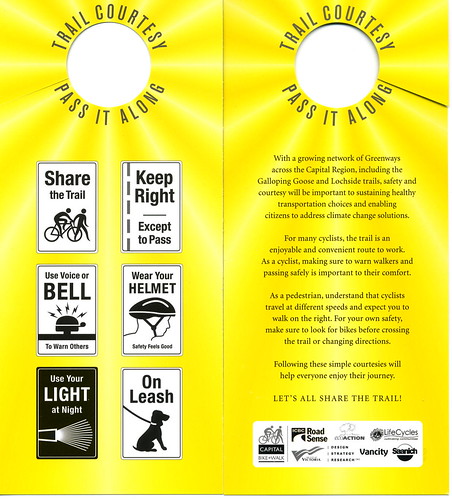
Trail (shared use path) courtesy tips

For Norm File2473

This is from Victoria BC from John Luton's Flickr stream. It bugs me to no end that there aren't "rules/etiquette" signs posted on DC's Metropolitan Branch Trail. Uniformly I have found that bicyclists ride to the right. But pedestrians are all over the trail, either walking in the direction of traffic or against it.

But since etiquette signs aren't posted, why should we be surprised?

(Otherwise, I love the trail--other than the lack of adequate signage generally.)

Labels: , , , ,

Tuesday, May 03, 2011

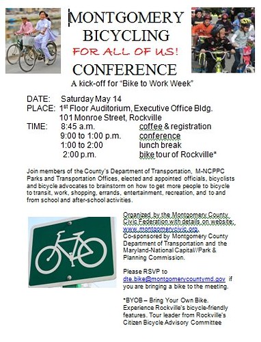
Montgomery County Bicycling Conference, Saturday May 14th

Last October, I did a presentation with Casey Anderson to the Montgomery County Civic Federation, about improving the environment for biking in suburban places generally and Montgomery County specifically.

There wasn't nearly enough time and I had to seriously truncate my presentation.

I challenged them, saying something like "There's a lot to this topic, more than we can do tonight, and if you really want to improve biking in Montgomery County, how about doing a longer set of sessions on a Saturday, and we can get into it in more depth."

Peggy Dennis, the President of the Montgomery County Civic Federation, took up the challenge, and this upcoming conference is the result. Because we didn't organize it with enough advance notice, we didn't get the plenary speakers we were trying for--but hopefully the conference will become an annual event, and there will be opportunities to get those great speakers that we were seeking. And yes, Casey and I will be doing a session...

There will be an opening session, a round up of presentations by agencies, including the Maryland State Highway Administration, which controls most of the major roads (arterials) in the county, the presentation by Casey and myself, which leads into a practical action planning session focused on repositioning bike planning and infrastructure towards achieving real gains in the suburban context, and an optional post-lunch bike tour of some of the infrastructure present in Rockville.

Montgomery County bicycling conference

Labels: , , ,