What to do transit-wise in Baltimore since the Red Line light rail program has been cancelled
Graphic by Victor Kerlow for the New York Times.
Barry Rascovar, a long time columnist writing on Maryland politics, has a great piece ("Plan B for Baltimore") at Maryland Reporter opining on "what's next for Baltimore?" given Gov. Hogan's dropping of the Red Line light rail program.
He criticizes the Governor for making a basic mistake, in not having a program of alternatives in place and ready to announce at the same time.
From the article:
Baltimore’s transit system might be called a bare-bones, 20th century model. Buses traverse the main thoroughfares radiating like spokes from downtown. Cross-town buses add to the mix of slow-moving public transit on heavily congested city streets.The reality that a lot of transit advocates gloss over is that there are a lot of problems with the proposed Red Line transit service, although it would have provided some improvements and greater transit service and access, it didn't do enough to shift Baltimore from having a couple of transit lines to the development of an integrated transit system. This is discussed in a great Baltimore Brew piece, "Analysis: How the Red Line found itself in a deep hole."
Baltimore’s Metro works exceedingly well — it is fast and clean — but only serves people who can reach its one line, from Owings Mills to Johns Hopkins Hospital.
The region’s north-south light-rail line is slow-moving through downtown, never connects directly with the Metro and isn’t heavily used.
There’s also a popular, city-subsidized Downtown Circulator with four routes that offer free service and actually connects people to where they need to go within the city. It’s becoming a drain on a money-poor city.
Suburban transit is a joke. Unless you own a car or live near a corridor road with buses, you’re out of luck in the Baltimore ‘burbs.
That’s a pretty weak transit operation. Killing the Red Line erases an opportunity to integrate and coordinate Baltimore’s public transportation network with a strong east-west line.
Yet there are steps the city and state can take to ameliorate this sad situation.
Although I will say that the proposals from the Right Rail group calling for improvements (not unlike my proposals below) could be problematic, e.g., it's cheaper to put an eastern heavy rail extension in a railroad or freeway alignment, but typically such alignments come at the expense of usage and the ability to reshape transportation and land use practices in quantum ways.
For example, while Prince George's County has many Metrorail stations, many follow a railroad alignment and weren't placed well in terms of being able to spur more intensive "transportation oriented development" projects.
By contrast, Arlington County rejected a freeway-based alignment and shifted service to the Wilson Boulevard corridor, sparking a significant improvement in the county's fortunes (although they are now dealing with the double whammy of BRAC relocation out of the county of military agencies, competition with cheaper commercial space in Alexandria, because ArCo's prices rose with the county's success, and new competition with Tysons and Reston as those areas now have Metrorail service too, along with lower lease rates).
Baltimore County too doesn't reap much value in light rail service, because most of the alignment follows an old industrial corridor and has minimal residential proximity, with a couple exceptions.
The challenge: to pick up the pieces, reassess and move forward, better and successfully
As Rascovar writes, Baltimore doesn't have the kind of transit system where high quality transit service is the leading element in reshaping the local economy and the location decisions of residents and organizations, simplifying mobility, and contributing in significant ways to quality of life.
It's hard to remember that Metrorail in DC has done this, because lately--the past 6 years and probably for long into the future--the system has significantly degraded.
But the reality is that in the areas of the Metrorail system where land use and transit service are complementary--especially in DC's core, in Arlington's Wilson Boulevard corridor, in Bethesda and Silver Spring in Montgomery County--the positive effects are clear and frankly, amazing, as development has been attracted, new housing has been built around stations, and new retail and restaurants follow the intensification.
It happens that while I have written a lot about improving and extending the DC area's transit system, I haven't felt comfortable writing at the same level of depth and breadth about the Baltimore metropolitan area, because I don't have the kind of day to day familiarity with their transit system and community.
Although I did lay out a basic vision concerning fixed rail transit, in a paper I wrote for the internal planning process for the update of Baltimore County's master plan. (And I included recommendations on transit accommodation of pedestrians and bicyclists in the bike and ped plan I did. While most of the section on experiential qualities of design related to pedestrian and bicycle matters were excised from the plan, the earlier drafts, including the section on transit, had been shared with the MTA, and had some impact on their planning for the Red Line.)
That paper, "From the files: transit planning in Baltimore County," didn't address issues outside of the county except in how they impacted the county, so it didn't discuss extending the light rail to Howard County or opportunities around the MARC railroad commuter service, and lacked detailed recommendations for East County (because my job in Baltimore County at the time required that I solely focus on West County). But it took as a given that a new light rail line serving Baltimore City, up to Towson, and south to Columbia would never be built. Instead, I mostly focused on improvements and extensions to the current lines.
- Linking the current light rail system with the subway system through a new underground terminus at the Hutzler Building in Downtown Baltimore
- Extending the subway line eastward, into Northeast Baltimore, terminating at the White Marsh district in Baltimore County
- Shifting the current light rail alignment from Falls Road to Lutherville through Towson, to serve Baltimore County's primary government, commercial, retail, and residential center
- Going forward with the Red Line (despite the problems with the alignment, it would have provided service to a key employment district in Southwest Baltimore County
- planning transit expansion in East County
- extending the current light rail line line into Howard County.
- extending the light rail line north about one half mile from its terminus, to serve more directly office districts in Hunt Valley.
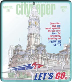 For many years, I encouraged activists there (people I interacted with on the now moribund EnvisionBaltimore e-list) to produce a piece comparable to a 2005 cover story in the Philadelphia City Paper about how to improve transit in Philadelphia.
 The piece, "Let's Go: 33 ways to reinvent, rethink and recharge our beleaguered transit agency," has 33 suggestions. Such a piece could have run to great effect in either the Baltimore City Paper or the now lamentably defunct Urbanite Baltimore monthly magazine on urbanism.
That kind of citizen-initiated visioning could have helped to reposition the dialogue and vision about what to do concerning the Baltimore area's transit system.
If the Baltimore metropolitan area had "great" transit, like Washington, it would begin shifting population and business back to the city. Without a great transit system, sprawl is overencouraged, and mostly this comes at the expense of center cities.
And don't knock citizen initiatives. The new streetcar lines in Dallas and Tucson came about because of citizen action, not top-down planning by transit agencies or city planning departments.
Rascovar mentions the Baltimore Circulator run by the City of Baltimore , which is an example of what I call intra-city transit ("Making the case for intra-city (vs. inter-city) transit planning") as a pretty good success.
It is, but the service costs more than is raised by the parking tax designed to pay for it and so the city is wrestling with what to do, as they can't afford to keep spending limited general fund monies on the program.
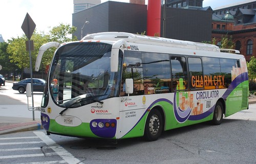
Charm City Circulator by So Cal Metro, on Flickr.
This editorial ("The Circulator's troubling finances") in the Baltimore Sun makes the point that perhaps a "community benefits district" should be created to pay towards the provision of service. I agree, but it should be termed as a "transportation benefits district," and integrate the parking tax, not unlike my recommendations for a reconfiguration of a similar program in Montgomery County ("Parking districts vs urban management districts").
Rethinking Baltimore-area transit
Rascovar makes these suggestions:
- Resurrect the western part of the Red Line, from Social Security headquarters in Woodlawn to the Lexington Market downtown, as a busway.
- Extend the existing Metro line from Hopkins to Northeast Baltimore and then White Marsh in Baltimore County.
- Expand the city’s Charm City Circulator routes to more neighborhoods; embrace the same approach in the suburbs.
- Develop transportation programs for getting city job-seekers to suburban employment centers. Free Jitney service from bus stops and transit stations to buildings in suburban business parks would help immensely.
- Expand bus service in metro Baltimore; enlarge the MTA’s fleet of buses by purchasing smaller vehicles; reduce the number of bus stops.
- Expand MARC commuter rail service; add frequent rush-hour/mid-day service to Aberdeen Proving Ground; turn MARC’s West Baltimore station into a bus/rail/circulator hub; open a new rail station/bus/circulator hub at Hopkins Bayview; turn the MARC Martin State Airport stop into a rail/bus/circulator hub.
- MARC’s West Baltimore station was planned as a key transit hub of the Red Line. It’s still a great idea if Hogan wants to show disgruntled residents of that impoverished area he cares.
- Hopkins Bayview and Martin State Airport are natural transit hubs, if the state builds large parking lots and adds circulator routes. This would be a godsend for eastern Baltimore County and East Baltimore residents in search of transit alternatives.
Note that planning for a Bayview MARC Station is proceeding independent of us scribes.
Riffing off his suggestions:
1. Rebrand and reposition transit service in Greater Baltimore more generally. Besides points made above and below concerning the subway, light rail, and rail passenger services, to reposition bus service in particular, MTA needs to consider the recommendations made in "Making bus service sexy and more equitable," although double deck buses probably aren't an option, the rest of the suggestions are relevant.
Also see "Purple line planning in suburban Maryland as an opportunity to integrate place and people focused initiatives into delivery of new transit systems."
2. Create transportation management districts and demand management programs. WRT to "develop[ing] transportation programs for city job seekers," my paper did discuss the need to create transportation demand management programs and systems in a detailed way. One recent example of the kind of service Rascovar suggests has been launched in Suburban Pittsburgh ("Transit Super Stop planned for Robinson," Pittsburgh Post-Gazette) which could be a model that suburban businesses and counties can understand.
3. Improve bus stops plus create a network of high quality bus stations at high use transfer points. My transit-related suggestions in the Western Baltimore County Pedestrian and Bicycle Access Plan DRAFT included creating a hierarchy of bus stops, including the development of a high quality network of bus shelters, not unlike those for the Mi-Way BRT system in Mississauga ("MiWay transit’s an exciting new direction for Mississauga," Toronto Star).
Such stations would be placed at key transfer points, such as at North Avenue and York Road in Baltimore City, in Towson's core (if the MTA could work with the County and a property owner, some ground floor space in an office building could be configured to do this kind of service, although property owners tend to be leery of the kinds of people who ride buses), etc.
In the DC area, the Shirlington bus station in Arlington County is an example of such a high quality station. Minneapolis' bus system has many examples, etc.
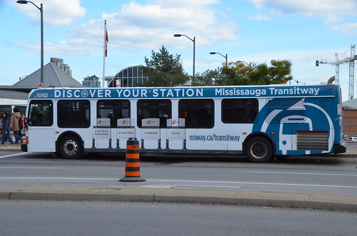
Mississauga Transit 0920 NFI D40LFR Bus At Sq One Terminal Wrap for New Transitway by drum118, on Flickr.
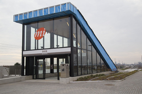
Dixie MiWay Bus station, Mississauga. Photo: Chris So, Toronto Star.
4. Build on the MTA QuickBus service of limited stop, faster service, on trunk routes. Note that the MTA's "QuickBus" service does a good job of providing more rapid bus service, by providing a limited stop service in highly used transit corridors. That service was introduced in the Ehrlich Administration and can be leveraged for broader repositioning of transit effectiveness.
Also see Envision Baltimore blog writings on creating a high-frequency service map for Baltimore bus service, culminating in Mark Szarkowski's map ("Mapping Baltimore's Frequent Transit Routes").
5. Apply the London Overground marketing, branding and service integration approach to MARC services in Greater Baltimore. My recent piece on repositioning MARC service ("One big idea: Getting MARC and Metrorail to integrate fares, stations, and marketing systems, using London Overground as an example") was mostly focused on service in and around DC.
Someone with a better handle on the railroad footprint in Greater Baltimore needs to come up with other MARC expansion proposals that could be worked into a comparable program for Baltimore.
Retired Baltimore City transportation planner Gerald Neilly has made many great suggestions on improving transit service. Like Rascovar, he has suggested for many years that a new MARC station be built at Hopkins/Bayshore Medical Center in East Baltimore.
But with improvements at West Baltimore Station and a new East Baltimore Station, and if it's true that the MARC station at Martin State Airport could be repositioned as a hub for East Baltimore County as Rascovar suggests (I only was there once, when I was reading too deeply and failed to get off the train at Baltimore's Penn Station) the idea of applying London Overground approaches to MARC service in Greater Baltimore begins to make sense.
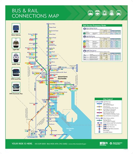
Note that unlike transit agencies in Greater Washington, MTA already does provided an integrated rail service map, including MARC, subway and light rail services, for Baltimore.
But a map isn't substitute for a real program along the lines of London Overground.
6. Upgrade the light rail vehicles to something modern and sexy. While I have suggested here and there that an update to Baltimore's hulking light rail vehicles would go a long way towards repositioning how people think about transit there, even though it would be expensive and there is plenty of useful life in the existing vehicles, I think this is an important enough point to be included in a comprehensive transit re/vision program for Baltimore.
I was watching a PBS travel show the other day and it included a stop in Bordeaux. The difference between how the Howard Street corridor looks in Baltimore with light rail service versus how transit is integrated into the built environment in Bordeaux, especially in the city center, is remarkable. Look at some youtube videos of tram service in Bordeaux...
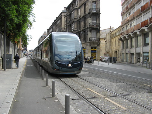
Bordeaux Tram by tsedmund, on Flickr.
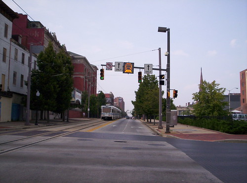
Light rail approaching, Howard Street, Baltimore.
(Yes, I know that the Alstom underground powering system isn't sold in North America. Another way to move catenary-free in city centers is with short term battery power.)
The points I made in "Transit, stations, and placemaking" about transit infrastructure as a key element of civic architecture need to be extended to include the vehicles/equipment used by transit systems, not just stations and alignments.
The Baltimore Light system is a perfect example of why. Despite the expense, planning for more frequent upgrades to transit vehicles as an element of civic design ("Design as a city branding strategy: transit edition") needs to be incorporated into how we plan for transit more generally.
7. Funding. Create a Transportation Renewal District for Greater Baltimore as a way to fund these kinds of transit improvements, along the lines of what I have suggested for Montgomery and Prince George's Counties ("To build the Purple Line, perhaps Montgomery and Prince George's Counties will have to create a "Transportation Renewal District" and Development Authority").
The "Right Rail" program
The Right Rail group suggests streetcars ("Pro-transit coalition seeks alternatives to Red Line on East Side," Baltimore Brew).
I guess if we think of streetcars as trams, in the way that European cities interoperate longer distance services--what in the US we would call light rail--with shorter distance services--what in the US we would call streetcars--BUT USING THE SAME EQUIPMENT, it's probably worth looking at their ideas.
Bilbao is a particularly good example of adding trams after building a subway system, as a way to provide better surface transit options in highly traffiked areas, with the aim of serving short trips.
-- "Beyond Moving People: Excavating the Motivations for Investing in Urban Public Transit Infrastructure in Bilbao Spain," Matti Siemiatycki, European Planning Studies, 2005
-- "Return to the Rails: The Motivations for Building a Modern Tramway in Bilbao, Spain," Matti Siemiatycki, Oxford University Centre for the Environment
While Paris is a great example of using trams for long distances. But there are so many European examples of great incorporation of trams/light rail into the built environment as a way that complements land use and shifts trips to transit...
There is a need to improve transit service in East Baltimore and East Baltimore County. I just don't have enough familiarity outside of White Marsh to be able to make good recommendations.
Trams in Bilbao.
Labels: car culture and automobility, fixed rail transit service, transit marketing, transportation planning, urban design/placemaking, urban revitalization


5 Comments:
I'd say a lot of this is the ghost of dead projects.
The Columbia Pike streetcar was the same. Made sense as a metro line in the 1960s. By 2010, the removal of jobs from Crystal City, creation of the quarter-pentagon off 395, the lack of a connection to the actual Pentagon, never made sense but was weighed down by history. (The crystal city streetcar, on the other hand did make sense)
Overly ponderous federal funding is probably part of this. Also look at the COG bikeshare plan (4000+ bikes out to reston) rather than what works (density).
And the constant linkages of real estate development + transit doesn't help. The purple line makes a lot of sense as a transportation project -- much less so as a development project.
Good point about projects as ideas that linger long after they no longer make sense.
wrt Baltimore, the biggest problem is that the metropolitan area has too much land capacity relative to demand.
So when it comes down to it Baltimore, Howard, Harford, and Anne Arundel Counties probably don't really want a great transit system, because it would recenter development back onto Baltimore City, in the way that DC has been resuscitated by transit access--although this is getting screwed up by WMATA's consistent string of operational failings.
I don't see a problem with the development-transit station link. It's no different than building at key intersections or alongside freeway exits.
But not every place can be intensified, unlike what is touted by the SG folks.
There just isn't that much demand. What Cervero calls "a string of pearls" makes more sense--nodes.
I "disagree" that the Purple Line doesn't make sense as a development play though, except like with the basic Metrorail system, it will take a few decades to see it play out.
It will refocus development, primarily in Prince George's County into the rail-transit-served areas of the county, the area ringed by the Metro and light rail.
By contrast, Metrorail never did that for PG, partly because of the disconnection between the lines, but also because the lines aren't well placed to stoke development, being in part in industrial rail corridors, not along the equivalent of Wilson Blvd.
Plus, PGC never directed much development to the stations, until "recently." What they should have done is relocated the government center from transit disconnected Upper Marlboro to a new center at one of the Metro Stations.
The opportunity for development is minimal in MoCo from the PL, except for a bit along U Blvd. Were it to be extended west to Tysons, it could have a lot of positive impact on the road network and congestion.
=====
speaking of demand and production, and capital vs. labor, an article in the Post about the resuscitation of Hostess said:
- before bankruptcy, 14 plants. After bankruptcy 5 plants.
- but then they sold one plant, and closed another one, leaving 3 plants out of the original 14
- a $20 million equipment and process upgrade in one plant means that plant now produces 70% of what had been produced by the 14 pre-bankruptcy plants.
- but with 500 workers instead of 7200 workers
- and grossly, tweaks to the chemical makeup of the products means they can stay on the shelf in the warehouse for up to 65 days, vastly reducing product discard (remember the old Hostess resale stores for old goods? I think for a time there was one in Florida Market, but it might have been Enttenmans).
Yes, my point about development is that PL isn't going to do much in MoCo, and it won't do much in PG county either. You lay out the structural reasons why transit didn't work but the other issue is you've got to make PG county attractive to move to, and that isn't working either. Basically you have to convince people to move there and nobody wants to. And i have no idea what a a commute from somewhere in PG county to a job in downtown Bethesda is going to look like but it isn't good.
(the strong of pearls is a good idea, take the SL -- the winner is RTC not Tysons)
Yep, bankruptcy is a bear. Public institutions aren't the only ones holding on to old models too long.
way to bring it back to reality. yes, I have to be dinged because I am thinking more theoretically.
On quality of life, placemaking, schools, perception of safety, urban design elements PGC lags significantly the other places.
So yes, just because you have a bunch of transit connected places, that's not enough.
It's the same thing in DC re NW and WNE and "upper" SE vs. East of the River.
it's not until most of the capacity in Upper NW/WNE/Upper SE is absorbed that development will in a significant way "jump the river".
It's not for lack of trying by the city. All the energy focused on Skyland and St. E requires lots of extranormal public involvement. That wouldn't be the case if they'd focus on the RFK site and Res. 13. But they let those areas languish even though there is demand, because of political considerations.
Anyway, this gets back to my point about how by not letting College Park be a college town for decades, they've lost the ability to utilize UMD as a way to drive quality of life and residential and business attraction to that part of the county.
It's a double whammy.
Thank you for providing such a valuable information and thanks for sharing this matter.
Post a Comment
<< Home