Rebuilding Place in the Urban Space

"A community’s physical form, rather than its land uses, is its most intrinsic and enduring characteristic." [Katz, EPA] This blog focuses on place and placemaking and all that makes it work--historic preservation, urban design, transportation, asset-based community development, arts & cultural development, commercial district revitalization, tourism & destination development, and quality of life advocacy--along with doses of civic engagement and good governance watchdogging.

Tuesday, June 30, 2020

Oklahoma City, Aubrey McClendon and Chesapeake Energy (now in bankruptcy)

Reuters photo.

Chesapeake Energy, the natural gas fracking behemoth based in Oklahoma City, just declared bankruptcy ("Chesapeake Energy, once a power in natural gas, files for bankruptcy: Company that led the fracking business succumbs to prices too low and debt too high," Washington Post).

Only in 2018, did I start writing an annual piece around the end of the year, an annual obituaries article with short vignettes of people who died during the year who were significant in some way to urbanism.

Had I written such an entry in 2016, I doubt I would have thought to mention Aubrey McClendon, the founder of the natural gas fracking giant Chesapeake Energy. He likely died in a suicide--a car crash--after he had been indicted for various improprieties.

McClendon and Chesapeake Energy led the natural gas fracking revolution which has contributed significantly to the expansion of supply and significant drop in price, leading to the conversion of many electricity generation plants from coal to natural gas.

And in 2014, I interviewed Rand Elliott, principal of the eponymous architecture firm Rand Elliott Architects, because among the many projects he designed for the Chesapeake Energy campus--done in Georgian style, I guess to reference the Chesapeake region in the Mid-Atlantic--he designed some high quality parking garages, including Car Park 3.

Car-Park-3, Chesapeake Energy Corporation, Oklahoma City, by Rand Elliott and Associates, architects
Car-Park-3, Chesapeake Energy Corporation, Oklahoma City, by Rand Elliott and Associates, architects. Each floor is color coded, created by special polycarbonate panels engineered and manufactured by Duo-Gard Inc. Photo: SCOTT MCDONALD/HEDRICH BLESSING.


Most parking garages are crap.  And given my focus on sustainable mobility, I suppose I should be happy about that.

But high quality parking garages contribute positively to urban form, when so much of the spaces and structures dedicated to supporting the car generally are negative contributions and the Chesapeake Energy garage was one of the influences wrt my general point that transportation infrastructure should be treated as an element of civic architecture so that urban design, placemaking, and aesthetic qualities are prioritized.

And while I mentioned it in a couple pieces, I never did write a full piece about it.

I am finally reading the book, published in 2018, The Next American City: The Big Promise of Our Midsize Metros by Mick Cornett, the Republican former mayor of Oklahoma City.  It's a phenomenal bthe cook which I'll write about later.

But McClendon features in the book in a few places, not just because of his company and its place in the city, but because of his role as a civic leader, and the many investments he and his firm made in the city.

These investments included being one of the founding investors in the Oklahoma City Thunder basketball team, the company's naming sponsorship of the arena in which the team plays, paying for the boathouse which helped to center the city and the renamed Oklahoma River as an international center for rowing, canoeing and kayaking ("River Attraction: Oklahoma River is becoming a big draw for Oklahoma City," Daily Oklahoman, 2013).

In 2017, the OKC Boathouse, which was the initial investment in a new riverfront, which in turn grew into the Riversports Rapids complex, was renamed in honor of Aubrey McClendon ("Boathouse building renamed in honor of Aubrey McClendon," Daily Oklahoman).

Many people leave complex legacies and Aubrey McClendon was one such person.

Monday, June 29, 2020

From more space to socially distance to a systematic program for pedestrian districts (Park City (Utah) Main Street Car Free on Sundays)

Staff at Fish Market in Old Town Alexandria set up socially distanced tables on the sidewalk and King Street in late May. (Pete Marovich/for The Washington Post)

There's been lots of reportage of initiatives in cities across the country to shift roadway space to pedestrian and bicyclists ("(More) People on streets and the coronavirus").

The next stage of this push is focused on accommodating social distancing and commerce by allowing restaurants to expand into the public space outside of their restaurants ("To expand dining options, restaurants take to the streets," Washington Post)..

What is new about this isn't using sidewalk right of way, but street right of way.

colorful sidewalk extensions into the street right of way, Trueform Group
Colorful sidewalk extensions into the street right of way even with the curb, Trueform Group

Sidewalk extensions, Halifax, Nova Scotia
Halifax, Nova Scotia.

I noticed a pop up ad in an article on a Washington Post article that Park City, Utah is doing this as well, on Sundays, for the core of its "downtown" (it's pretty small) Main Street commercial district. (The ad below is from the Historic Park City website and is different from what I saw online.)


-- "Shop, Dine & Stroll || Sundays on Main Street are Car-Free!Historic Park City commercial district revitalization initiative

The reason that I mention this is that traditional commercial districts should have been doing this all along, long before the coronavirus, as a way to strengthen and call attention to traditional commercial districts as pedestrian and people focused as opposed to car focused.

-- "Town-City branding or "We are all destination managers now"," 2005
-- "Now I know why Boulder's Pearl Street Mall is the exception that proves the rule about the failures of pedestrian malls," 2005

One of the only regularized initiatives like this that I had been aware of before the coronavirus--outside of very special events--is how Denver's Historic Larimer Square has a "Dining Al Fresco" promotion in the summers, where one night each month they close off one of the streets for dining, which is served by the abutting restaurants.
Larimer Square, Downtown Denver, dining in the street/Dining Al Fresco

Larimer Square, Denver, Dining Al Fresco

In the face of the coronavirus, Montgomery County, Maryland has developed a similar initiative for its main town centers, Bethesda, Rockville, and Silver Spring ("Bethesda streets close to make space for outdoor dining," WUSA-TV; "Silver Spring, Rockville, Takoma Park close streets to allow for expanded outdoor seating," Bethesda Magazine).

The difference between Park City is that in some of the Montgomery County communities, in particular Bethesda--a leading restaurant destination for Western Montgomery County--this is every day, not just on Sundays or on weekends.
Streets in Bethesda, Maryland closed to accommodate outdoor restaurant patios and social distancing

Separately, going on a couple years, Takoma Park also in Montgomery County but a separately incorporated city of its own, is the only community in the area -- pre-coronavirus -- to have legalized the ability for restaurants to take over abutting parking spaces as restaurant patio spaces.
An in-street restaurant patio for Takoma Beverage Co. using parking spaces, Carroll Avenue, Takoma Park, Maryland
Parking space patio outside of the Takoma Beverage Co.

This is an example of implementing measures that have been developed from the parklet movement, which started out as a guerrilla and tactical urbanism initiative but is now a mix of guerrilla and officially-sanctioned projects.

But it's a limited takeover of parking spaces, not an expansion into the entire street (although now Takoma Park is doing that too).

Moving from temporarily closed streets to permanent pedestrian districts?  While in the past I have been pro-pedestrian, I had been skeptical of pedestrian-only zones in the U.S., having seen multiple examples of failure, including the US's first example of a downtown pedestrian mall, in Kalamazoo, Michigan.

Kennedyplatz, Essen. 

But visiting Germany in 2014, I saw such districts of varying types and sizes in Essen, Dortmund, and Hamburg, and in 2018, in Liverpool--a very large district in the core--and smaller areas across London, and I came to understand that the issue wasn't pedestrianizing per se, but in starting small--as little as one block--or at least appropriately, in those places where there is enough activity, access and movement to make such places ("wildly") successful.

Exhibition Road urban design treatment, South Kensington, London
Exhibition Road in Kensington borough is a shared space, mixing cars and pedestrians.  It looks cool, but it doesn't work for either pedestrians or cars.

While shared spaces might work in the Netherlands, where they originated ("Hans Monderman obituary," Guardian, I don't think they work in car-dominated societies like the US or the UK.  Instead, it's an example of what I call "designing conflict in," which creates the opportunity for problems, rather than what planning is supposed to do, which is "designing conflict out."

-- "Exhibition Road -- review," Guardian
-- "MP calls for pedestrianisation of Exhibition Road amid dispute over accident figures," Dezeen

I wrote about one such opportunity for creating a pedestrian district in DC in more detail last year:

-- "More about making 17th Street between P and R a pedestrian space on weekends."

Unforunately, instead, DC Department of Transportation and Washington Area Bicyclists Association are fervently in favor of adding a cycle track to the street.

But there are multiple places where this could work, elsewhere in DC and the metropolitan area, and of course, across the country, starting with as little as one block, and working outward, expanding as success dictates and warrants.

-- "Making "Downtown Silver Spring" a true open air shopping district by adding department stores," 2018
-- "Revisiting the Purple Line (series) and a more complete program of complementary improvements to the transit network," 2019
-- "Sadly, DC won't show so well during the Baseball All-Star Game," 2018
-- "Urban design considerations for the area around Washington Nationals Baseball Stadium in advance of the 2018 All-Star Game, 2017

Earlier this year, Alexandria, Virginia began moving forward on expanding the pedestrian area at the foot of King Street ("Alexandria Virginia looks to pedestrianize the foot of King Street abutting the waterfront").

While Essen's district was super cool (inadvertently I was there during a weekend music festival and my hotel was across from a major plaza, Kennedyplatz), and Hamburg's very successful and including a transit mall, and Liverpool's was very large, and on a Friday night, it was booming, one that impressed me the most was Mare Street in Hackney Wick borough

It's a couple block long "pedestrian mall" for a shopping and civic district adjacent to the Hackney Central London Overground station.
Mare Street/Narrow Way pedestrian zone, Hackney, London
Mare Street/Narrow Way, Hackney borough.

It turned out the walking street, which looked like it had been there forever, was only a converted a few years before.  And it was controversial ("Concerns that pedestrian zone in Hackney Central will kill off trade," Hackney Gazette).  Although it looked plenty successful to me, 5 years later.

But my experience in the UK and Germany, and of course there are many other such places not only in various countries in Continental Europe, but across the UK, did in some respects reiterate my concerns about success.

While I think it's possible to have small pedestrian districts in the US, most places lack the concentration of population, strong activity centers, and complementary transit systems that make these districts not only work but thrive in Europe ("Walk the Lijnbaan: decline and rebirth on Europe’s first pedestrianised street," Guardian).

In the US, there are a few pedestrian malls that thrive--Boulder, Burlington, and to some extent, Charlottesville and Madison--but all are in college towns where there is a dense population of students, most without cars.
Charlottesville pedestrian mall
Charlottesville.

Santa Monica and Winchester, Virginia are among other places that have such pedestrianized spaces.  The one in SM is cool, but it's lost key anchors and peters out at the ends, even though one end now includes the terminus of the Expo Line light rail.  Winchester has the same problem, although it has none of SM's advantages--resort community, nearby beach, awesome weather, large population, and transit connectivity.

Third Street Promenade, Santa Monica
Santa Monica.

Winchester pedestrian mall
Winchester

How to look at expanding pedestrian facilities systematically in the coronavirus era and beyondTransit.  I just came across a January Chicago Tribune article about how the Chicago area transportation planning organization, for the first time, released a study evaluating the pedestrian and bicycle access conditions at the region's railroad and heavy rail transit stations ("Where do I walk? Study finds several Metra, and some CTA stations, have a shortage of nearby sidewalks").

From the article:
A lack of sidewalks near several suburban Metra stations and a few CTA stations makes it harder for pedestrians to safely walk to transit, according to a new, first-of-its-kind report by the Chicago Metropolitan Agency for Planning.

“If people don’t feel comfortable walking to the train, they’re not going to use the train,” said Stephanie Levine, associate policy analyst for CMAP.

The analysis found that within half a mile of stations, just 35 out of 242 Metra stations had “excellent” coverage with sidewalks on one or both sides of almost all roads. Eighteen Metra stations had no sidewalks on 50% of the roads within a half-mile of the station.
What's amazing to me is that this had never been done before--although note that the Active Transportation Alliance had received grants to do similar geographic-specific studies over the past decade.   And why isn't this a standard element of station area planning from the outset.

Note that Montgomery County just released a Purple Line Pedestrian Accessibility Report for their under construction light rail line ("Purple Line stations need safer access for pedestrians, planners say," Washington Post).

(And in the draft plan I did in Baltimore, I included a section of recommendations for transit-related improvements, including the then proposed Red Line light rail, which ended up not being approved.  And in early planning stages for the Purple Line, I was asked to share that section of the planning document.)

I guess that's pretty rare, although Seattle has done this around light rail planning too.  The MoCo methodology is worth being adopted more widely.

But the reality is that most transit agencies have failed to ensure that stations are accessible by modes other than cars. In their defense, they'd probably say that the local jurisdictions are responsible for this kind of planning and infrastructure, and they're right, but if they are to be "customer"/rider/service oriented, they need to step on this.
Bicycle gutter, Lutherville Light Rail, west platform
The platform for the west side of the light rail station in Lutherville, Baltimore County, Maryland, has a stairway but no sidewalk connecting it to the nearby street.
Trail to the Lutherville Light Rail stop, adjacent to Greenspring Drive, Baltimore County

Although some agencies are leaders in planning for station access including the Utah Transit Authority ("UTA Works to Overcome 'Toughest Mile' Challenges," Metro Magazine).  The report produced out of the UTA project, the First/Last Mile Strategies Study (lead consultants Fehr & Peers), is particularly good.

Catchment area of public transit stops for pedestrians and cyclists
Catchment area of public transit stops for pedestrians and cyclists.  Montreal,  p. 135, Planning and Design for Pedestrians and Cyclists: A Technical Guide, produced by VeloQuebec.

The DC area Metrorail agency did a similar study c. 2009, for walking and biking.  (Then again, the system had been operating for more than 30 years by then.)  There are still plenty of gaps in terms of pedestrian access, intersection treatments, sidewalks, bicycle parking, etc., even though all the city stations have been open for decades.

I remember coming across an article on the bus system in Greater Minneapolis, and a recognition that lack of sidewalks significantly impacted bus ridership in the suburbs especially ("Metro Transit says bus stops are improved with better signs, more shelters," Minneapolis Star Tribune; "Bus Stops as Community Assets," University of Minnesota graduate student project).

I recommend that as part of transit line and station planning, public improvement districts can be created to implement full vertical and horizontal "ground" access programs.

-- "Revisiting creating Public Improvement Districts in transit station catchment areas," 2020, original entry, 2016

Sidewalk and street networks.  In response to the coronavirus, Matt Elliott, a contributor to the Toronto Star, wrote a piece ("Where should lanes be closed for pedestrians and cyclists as the city comes back to life? We crunched the data") providing a systematic way to look at areas of high pedestrian use, hospitals, and supermarkets, to identify and prioritize areas where right of way dedicated to pedestrians should be increased.

Toronto's 100 busiest pedestrian intersections, by Matt Elliott

Toronto's 100 busiest pedestrian intersections, by Matt Elliott.

Toronto's 100 busiest pedestrian intersections + hospitals and supermarkets, by Matt Elliott
Blue dots are for high use pedestrian traffic at intersections, red dots are hospitals and major health clinics, orange dots are grocery stores.

In the Baltimore County study I did, I advocated similar approach, using bus stops and transit stations, elementary and junior high schools, and local commercial districts as the loci.
Baltimore County, One mile diameter from schools and transit stops

For a presentation I did in Montgomery County, the County planning department graciously produced a similar kind of map.
One mile radius from transit stops, Montgomery County, Maryland
One mile radius from transit stops, Montgomery County, Maryland.  Map by Matt Johnson.

Conclusion.  We have the ability to expand space devoted to sustainable mobility in systematic ways, in ways that promote high quality urban design and placemaking.

I think what we lack is the will to shift space from cars to pedestrians, especially in bold ways.

But too often, our desire may be ahead of where we are practically speaking.  At least here in Salt Lake City, the city responded, like lots of other places, and shifted many streets or street right right of way to shared space or bike/pedestrian exclusive zones -- but no one is using them (at least at the times when I check them out).

So we need to be conscious of where we focus such efforts, to ensure that they are successful and visible in positive ways, so that further and future initiatives aren't scuttled in response to failure or the perception of failure.

Labels: , , , ,

Thursday, June 25, 2020

"Utility" infrastructure as an opportunity for co-locating urban design and placemaking improvements

Often utility corridors may be one of the only opportunities to create trails and pathways in places where private property rules.  It was frustrating when I worked a bike and pedestrian plan for Baltimore County, because there wasn't a good way to create a dedicated pathway between Baltimore City and the county center in Towson.

There was an electricity transmission corridor, but it had tough topography, and my boss rejected it out of hand.

Image: Friends of the Washington and Old Dominion Trail.

To me, given it was the only option, I didn't think we had that luxury.  Although I lost on that one, surprisingly the utility company was willing to consider it.  (Another similar missed opportunity was a utility and stormwater piping corridor along the Patapsco River.)

One of my arguments is that providing a regular use within the corridor could add to security, providing "more eyes on the street."

This was a few years before an attack on an electricity substation in California ("Sniper attack on California power grid may have been 'an insider,' DHS says," CNN).

The Perils for Pedestrians public access television program has an episode, "Gallery of Power Line Right of Way Trails," featuring 26 (!) different examples including in the DC area.

Transformational Projects Action Planning.  From the standpoint of what I call TPAP, harvesting opportunities for urban design and placemaking improvements simultaneously with the development of other infrastructure ought to be a no brainer.

-- "Why can't the "Bilbao Effect" be reproduced? | Bilbao as an example of Transformational Projects Action Planning"

This could also be a key element of "Green New Deal" planning.

Transportation Infrastructure as an Element of Civic Architecture.  Before TPAP, I wrote about "transportation infrastructure as an element of civic architecture."

-- "Transit, stations, and placemaking: stations as entrypoints into neighborhoods," 2013
-- "Transportation infrastructure as a key element of civic architecture/economic revitalization #1: the NoMA Metrorail Station," 2016

Partly I was inspired by learning about "Railroad Gardening" or "Railroad Beautiful," the late 1800s progenitor to "City Beautiful" ("The Railroad Beautiful: Landscape Architecture and the Railroad Gardening Movement, 1867-1930," Landscape Journal).

 One of the pioneers was the Boston & Albany Railroad, which invested in railroad stations--designed by H.H. Richardson and plantings--by Frederick Law Olmsted--as an element of marketing.

Rails and trails.  While converting abandoned rail lines for trails has been going on for decades, the idea was that this was to be a form of railbanking, preserving the right of way for potential rail use in the future.

-- Rails to Trails Conservancy

The problem with this is that use as a trail builds a constituency to keep it as a trail and not as a transit corridor.

This has been an issue wrt the Purple Line light rail project in Suburban Maryland, and the organization Friends of The Capital Crescent Trail | Save the Trail!, although partly many of the members, homeowners along the line with their backyards abutting the trail, were more more interested in not having a frequent transit line there.

This also comes up with "temporary" park uses for lots not ready to be developed. See "Predictable outcome: people want to make a temporary park permanent."

 It's why developers prefer to keep the space vacant. (It's a similar phenomenon when people reside in industrial-manufacturing areas, like the "Meatpacking" District in NYC, or in farm-adjacent lands in suburbanizing rural areas.)

rail-and-trail paved path seattle longtail cargo bike familyBut there is a rise of incorporating trails as part of existing or new rail transit projects, including the SMART rail project in Sonoma and Marin Counties in California, trails alongside the Expo Line in Los Angeles, and the Purple Line.

Elliott Bay Trail.  Photo: Green Lane Project credit Adam Coppola Photography. 

In Seattle, part of the Elliott Bay Trail in the city is alongside a working freight rail line, and very close at that.  DC's Metropolitan Branch Trail follows part of the rail line that is its namesake.

High Line in New York City. The adaptation of an abandoned elevated freight railway line in Manhattan for a park is well known.

High Line, NYC

High Line, NYC, freight line

 But this isn't "co-locating" a placemaking use with an existing utility use. What I am more interested in is using utility spaces that can support "mixed use" and are otherwise eyesores.

-- "The inside track on the High Line," NPR
-- "The High Line has been sidelined. When it reopens, New Yorkers may get the park they always wanted," Washington Post
-- "New York's High Line: Why the floating promenade is so popular"
-- "Why New York’s High Line is the perfect source of gardening inspiration"

Note that the first example of this kind of adaptation is in Paris, the Promenade Plantée/Coulée Verte ("Paris' Elevated Park Predates NYC's High Line by Nearly 20 Years (and It's Prettier, Too), TreeHugger) although it gets little notice.in the US.

Bentway in Toronto. The Bentway uses space under a freeway for park uses.

-- Bentway Conservancy

 It's not the first example of reusing space under freeway ramps and pylons, but as a premier example of doing this well, it's an example for others ("Under freeway ice skating track opens in Toronto").

Bentway ice skating track under construction, Toronto
Bentway ice skating track under construction, Toronto.  Photo: Eduardo Lima, Metro News

Under freeway spaces.  Many places do put parking under freeway ramps.  It's an acceptable use too. Or at the very least, treating the pylons as opportunities for murals.
Corktown freeway underpass pylon murals, Toronto
Corktown freeway underpass pylon murals, Toronto.  David Cooper / Toronto Star.  This pillar, called The Worker, recalls the neighbourhood’s working-class roots 

Proposals for electricity transmission corridors in Montreal.  There are two different projects.  The first is the Green Corridor project by Hydro Quebec, the province's electricity provider.

While the primary impetus is to upgrading the utility facilities, including substations, at the ground level there will be urban design-related improvements serving the community, including include separate bicycle and walking paths, other recreational amenities and landscaping.

Although at least one group has called for undergrounding of the transmission lines altogether ("Hydro-Québec begins groundwork for controversial substation pylons in D.D.O.," Montreal Gazette).

Another project is to reposition electricity transmission corridors as "Biodiversity Corridors."

The Biodiversity Master Plan was created by the winners of an international design competition, the team was composed of four firms: civiliti; LAND Italia; Table Architecture; and Biodiversité Conseil.

Rendering, Poirier Boulevard.

They proposed a re-do of three electricity transmission corridors, re-introducing plantings, adding trails and other amenities, and support to fauna, along three major city arterials in St. Laurent borough, which as a more suburban part of the city, is car-dominated,

Water infrastructure in Medellin.  I write about Medellin from time to time because of how it has used investments in social and transportation infrastructure -- transit including bicycle sharing, gondolas, and escalators -- and libraries, parks and other facilities in association with infrastructure projects.

The program is funded in large part by revenues from the municipally owned utility, which runs both electricity and water systems.

Their approach is now called "social urbanism" by planning theorists, and it has contributed to a 90% drop in the murder rate in that city.  (The rate is still high, over 600 deaths each year, but that's 5,400 fewer than the peak rate!)

-- "Medellin: from narco terrorism to a hub of innovation & social urbanism," RSA
-- "'Social urbanism' experiment breathes new life into Colombia's Medellin," Toronto Globe & Mail
-- "Medellín's 'social urbanism' a model for city transformation," Mail & Guardian
-- "Medellín slum gets giant outdoor escalator," Telegraph

Medellin, Northeastern Urban Integration project, converted typical arterial into a multi-modal, pedestrian focused street
In association with the construction of a gondola-based transit system in Medellin, the Northeastern Urban Integration project, converted typical arterial into a multi-modal, pedestrian focused street. 

One project I wasn't familiar with adapted water reservoir infrastructure to add public spaces and facilities to neighborhoods that had little such space before ("The Story of How Medellin Turned Its Water Reservoirs into Public Parks," ArchDaily). From the article:
While developing a master plan for Medellin's urban lighting system, EPM, Medellin's public utility company, analyzed the Colombian city's infrastructure and nocturnal lighting system by superimposing a map of the system over a map of the city. What they found was an urban landscape blotted by "islands" of darkness.

Much to the surprise of the utilities company, the dark spots were actually 144 water tanks that were initially built on the city's outskirts; however, thanks to the progressive expansion of Medellin's city limits, the tanks now found themselves completely surrounded by the informal settlements of the Aburra Valley. Even worse, they had become focal points for violence and insecurity in neighborhoods devoid of public spaces and basic infrastructure.
UVA La Alegría.

Through their Sustainable Urban Interventions Department (DIUS), EPM analyzed the 144 water tanks "based on aspects like usable land, population density, the neighboring community's needs, geological restrictions, the expansion of the aqueduct, and the surrounding area." They later chose 32 tanks and, from there, narrowed their list down to the 14 tanks most in need of intervention, giving birth the to ambitious project of creating quality public spaces in Medellin's poorest neighborhoods, dubbed the UVA or Articulated Life Units.
Water reservoirs in the US.  Sometimes in the US, water reservoir areas are treated as parks, but over the past decade this has been seen as controversial because of the potential for water contamination as a spillover from the use, or fears of terrorism.  Although now, the EPA is requiring that treated water no longer be stored in open reservoirs.

The Baltimore City Department of Public Works is in the middle of a $134 million project to bury a pair of water tanks and turn a portion of the existing Druid Hill reservoir into parkland. (Jerry Jackson, Baltimore Sun)


Ironically, what that will mean in some reservoirs is the ability for more park and recreation uses ("Remaking Baltimore's Druid Lake: $140 million water project has some residents hopeful, others concerned," Baltimore Sun).
Although this comes at the expense of water views and water-based recreation opportunities.

Labels: , , , ,

Tuesday, June 23, 2020

Obituary: Joseph Corcoran, housing developer, Boston

Over the past few years, at the end of each year, I try to run a piece featuring obituaries of people who in my opinion are notable to urbanism. I can't claim it's a definitive article. It's just obituaries I've come across in my reading, on listservs, etc. And a good number of the people I wasn't aware of.

Some people deserve to be noted away, and I think that Boston real estate developer Joseph Corcoran is one such person. Even though most of his projects were typical market rate projects, he was committed to providing high quality housing for everyone, and has pushed various initiatives in Massachusetts.

His first major project was pathbreaking, the rebuild of the then unsuccessful Columbia Point public housing development in Boston.

Community pool open to all residents regardless of income, overlooking Boston Harbor.  Photo: Brad Vest.

Now called Harbor Point, it may be the first example of adaptively rebuilding a public housing project to incorporate market rate housing as a way to change the social and economic trajectory of the community.

It was helped by a great location on Boston Harbor--now also home to the JFK Presidential Library.  Goody Clancy, an architecture and planning firm that always impresses me, were the designers of the rebuild.

This is what I wrote for the general obituary entry:

Boston Globe photo.

Joseph Corcoran, Boston real estate developer ("Columbia Point gives way to upscale Harbor Point," Boston Globe, 2015). According to the website of the Boston College Center for Real Estate and Urban Action, which he founded, he:
earned a national reputation by transforming a Boston neighborhood now known as Harbor Point from a crime-ridden housing project into a safe, vibrant mixed-income community that the residents are proud to call home. Joe blazed the trail for mixed-income developments by helping to enact state legislation, chairing the real estate registration board, and founding a nonprofit to revitalize distressed urban neighborhoods. "People don't grow up in poverty," he says, "they grow up in neighborhoods."
This was probably the first example of the rebuild of a "squalid public housing project"--this one was originally called Columbia Point, into a mixed use development that included market rate housing ("Joseph Corcoran Rescued a Squalid Boston Housing Project," Wall Street Journal): "Looking Back at the Success of Harbor Point ," Architect Magazine.

And it was Corcoran who approached HUD about taking on the rebuild, not the other way around.  According to the WSJ:
Completed in 1990 at a cost of more than $250 million, Harbor Point created a neighborhood where lawyers and graduate students lived alongside people qualifying for subsidized rent. They shared swimming pools, a gym and views of Boston’s harbor and skyline.
-- Video interview, Boston Foundation
-- Privately-Funded Public Housing Redevelopment: A Study of the Transformation of Columbia Point (Boston, MA), Institute for International Urban Development

Although some argue that the redevelopment of the site came at a great cost in terms of reduced numbers of housing units available to low income tenants.  The split was about 1/3 low income; 2/3 market rate ("REVITALIZATION OR REPLACEMENT? TWO CASES OF REDEVELOPMENT IN BOSTON: COLUMBIA POINT AND COMMONWEALTH," Joint Center for Housing Studies).


This is the criticism I make generally of the HOPE VI public housing redevelopment initiative launched by the Clinton Administration. Communities were "improved" but a significant amount of low income housing was lost.

And the negative impacts of displacement of the formerly housed residents could be far reaching, such as for Prince George's County, which became the destination for many of DC's families displaced by public housing redevelopment ("Shouldering the Burden," Gazette, 2003).

Recently, I came across an(other) exemplary urban planning initiative by the City of Toronto, Growing Up: Planning for Children in New Vertical Communities. One of the sections of the webpages for the planning documents include case studies.

One is of the St. Lawrence neighborhood. Which is a medium-rise community, built new in the 1970s and reflecting the architecture of the time. It's considered very successful.

One of the things they got right that was totally bobbled by HUD in the US, was the the development of complete communities, with schools, social and community facilities, and retail as part of each building. The ground floors were devoted to non-housing functions -- mixed use -- with housing above.

How cool would it be to have your elementary school on the ground floor of your apartment building?

Schematic/program for the Crombie Park Apartments in St. Lawrence.

For the most part, HUD rules require that public housing be homogeneous developments without retail or other service functions.

They built housing, but not neighborhoods-communities.  Likely this contributed to the "failure" of many public housing projects.


Labels: ,

Wednesday, June 17, 2020

Monuments as public art, historiography, and change

Decades ago, in college, a group of us came to DC for a summer march, and we stayed with people who lived in Baltimore, near Memorial Stadium.  We walked in to a Baltimore Orioles game late in the game so we didn't have to pay.

While I know that naming stadiums and other facilities in honor of people who died in wars is supposed to be the right thing to do, at the same time we overlook calling attention to the monumental pain and waste and ever since then, I joke to myself that such facilities should be named "War Dead Stadium" etc.

Pulling down the statue of Edward Colston, slave trader and Member of Parliament, Bristol, UK (England)
Pulling down the statue of Edward Colston, slave trader and Member of Parliament, Bristol, UK (England).

Given the ongoing toppling of statues of people associated with various forms of subjugation (Confederate memorials, Christopher Columbus, slave trader Edward Colston in Bristol, England, etc.) that is spilling out from the George Floyd protests, it's worth reprinting these couple of posts from a combined entry in 2017.

While for the most part I do believe that it's right to remove statues designed to engender fear, others like of Thomas Jefferson or Christopher Columbus, are more complicated ("What to do when the Confederate statues come down? Leave the pedestals empty," Washington Post).

In any case, imagine if the historiography of Monument Avenue in Richmond ("Along historic Richmond street, residents grapple with Confederate legacy," Washington Post) had been recast as a discussion of slavery, the Civil War, and Jim Crow, instead of a memorial to the "Lost Cause" and State's Rights.

Kehinde Wiley, Rumors of War (2019). © 2019 Kehinde Wiley. Courtesy of the Virginia Museum of Fine Arts, Times Square Arts, and Sean Kelly. Photos: Ka-Man Tse for Times Square Arts.

Note that I meant to but didn't get to writing a piece about Kehinde Wiley's statue, "Rumors of War."

The statue, 29 feet tall and weighing 8 tons, was first displayed in New York City ("Kehinde Wiley's Times Square Monument: That's No Robert E. Lee," New York Times) by the Times Square Arts organization before being moved to its permanent site in Richmond ("Installation begins for Kehinde Wiley's 'Rumors of War' at VMFA; street closures, shuttle buses for Tuesday's unveiling," Richmond Times-Dispatch).

It's Wiley's response to a Confederate monument a few blocks away from the Virginia Museum of Fine Arts (nearby, there is a Confederate War Memorial structure, and occasionally self-appointed pro-Confederate guides will approach you, at least years ago when we wandered in; if you didn't know better, because of the proximity, you might think the Memorial is part of the Museum).

Imagine a modern historiography for Monument Avenue, with new monuments like Wiley's which challenge convention and what people thought was "settled history."

There's a lot of important Civil Rights history within Virginia (Civil Rights Movement in Virginia, Virginia Museum of History and Culture) that could be mined to create a reinterpreted Monument Avenue Historic District, such as:
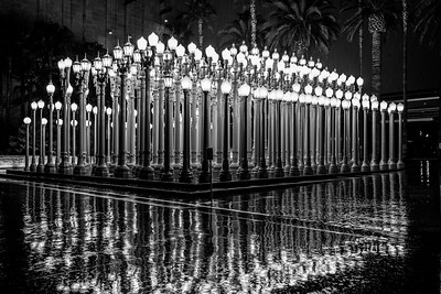
Or the removed statues could be made into a new kind of installation and reinterpretation, along the lines of Chris Burden's "Urban Light" outside of the Los Angeles County Museum of Art.
Urban Light

A related issue is proposals to rename military bases named after Confederate military personages.  The military is ok with the change, President Trump not ("GOP senator: Proposal to remove Confederate names from military bases 'picks on South unfairly'," CNN).  It's but another element in creating an institutional culture of racism.

Can you imagine the US military having a base named after Hitler or Goebbels?  Or King George III or Prime Minister Tojo.  Or Osama Bin-Laden, etc.?

This image could be used to make a great outdoor art installation.
Lunch counter sit in at the F.W. Woolworth on Granby Street in Norfolk, Virginia
Some of the young African Americans taking part in a sit-in at the Woolworth store on Granby Street in Norfolk were Norfolk Division of Virginia State College students dressed in ROTC uniforms. (Virginian-Pilot File photo)

=============================
A brief comment about Confederate monuments
8/20/2017


It's hard to disagree with people arguing that such monuments weren't erected to call attention to history as much as they were to sow fear with regard to black-white relations.

But removing all of the "sculptures" from the public space makes it that much harder to provide the greatest possible opportunity for interpretation, reinterpretation, challenge and contestation.


I can see changing the name of streets--e.g., Alexandria, Virginia ("Alexandria wants your help in renaming Jeff Davis Highway," WTOP-Radio) is renaming its segment of Route 1 so that it will no longer be named for Jefferson Davis, the president of the Confederacy.

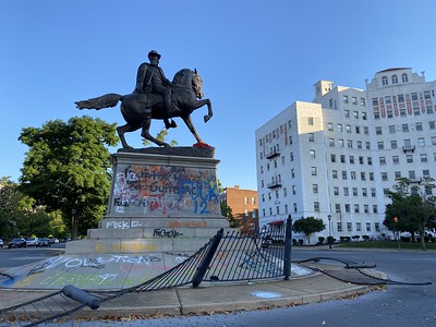
Richmond, Virginia has chosen to keep the monuments on its prominent boulevard, Monument Avenue, where all but one of the statues and monuments venerate Confederate personages. From the Wikipedia entry:
Monument Avenue is an avenue in Richmond, Virginia with a tree-lined grassy mall dividing the east- and westbound traffic and is punctuated by statues memorializing Virginian Confederate participants of the American Civil War, including Robert E. Lee, J.E.B. Stuart, Jefferson Davis, Thomas "Stonewall" Jackson, and Matthew Fontaine Maury. There is also a monument to Arthur Ashe, a Richmond native and international tennis star who was African-American. The first monument, a statue of Robert E. Lee, was erected in 1890. 
But I would argue it is reasonable to consider removing such prominently located statues and sculptures because their position in highly visible and centrally located places of prominence in the public realm framework imply acceptance and veneration more than they do the opportunity to provoke rethinking. 

Certainly, as a historic district, Monument Avenue hasn't been utilized as a place to discuss how statuary and monuments can be used to project a way of thinking and subjugation, based on the description of the district by the National Park Service.

But a piece, "Bring bigger picture of history to Monument Avenue," in the Norfolk Virginian-Pilot argues that Monument Avenue presents such an opportunity:
Monument Avenue should become the place where we see and feel our national shame. The statues along it, many artistically splendid, should be accentuated with extensive historical connotations so that they might provide a justifiable sense of societal advancement. Let them celebrate our significant and, yes, ongoing efforts to reject our past failings.

And add more monuments. Surely some of our nation’s corporations and foundations would step forward to support the building of new, glorious statues recognizing the sacrifices and achievements of those who fought to defeat racism and bigotry.

Imagine a grand marble representation of the Underground Railroad, which guided former slaves to safety and freedom. How about another marking the 10 greatest contributions to sciences, arts, athletics, industry and public service by African Americans since the Civil War? Perhaps another saluting the Tuskegee Airmen?

How about individual statues as well to recognize those who are seldom celebrated? ...
By contrast, moving all of these monuments to museums obscures what they represent.  Sure, they will be viewable and accessible, but will require deliberate action in order to engage with them and the history they represent.  But not having such objects out in the open, an opportunity to confront more directly the nation's negative history is also lost.

Richmond protest, graffiti on Confederate monuments[added] Certainly, tagging the statues is a form of reinterpretation and expanding the didactics describing them, when otherwise no alternative interpretation is provided.

This came up in a conversation at Thanksgiving Dinner, shared with our next door neighbors and their family, who hail from South America.

We were talking about US Imperialism and the impact on Latin America, and how they experienced it first hand, which is why they have such a complicated relationship with the US.

But also how the average American knows very little about this.

I explained that it isn't until college--and only certain colleges at that--when the average American has the opportunity to be exposed to alternatives to the typical mythology about the US and its place in the world, especially as a force only for good, as is presented in K-12 history and social studies textbooks.

The reality is that as a country, our external relations aren't always "a force for good," and internally as a nation we have many faults too, in race relations, economic opportunity, and politics.

Certainly, an identification and consideration of the power of whiteness isn't something that most people are willing to do nor are they willing to examine their sense of privilege and power that results from it.  People want to maintain their power and prefer to label people who disagree as "the other."

Ironically, the process is comparable to how motor vehicle operators treat other modes as usurpers ("Criminal Bicyclists," "Streets as places versus 'Motordom'," "Societal change (and sustainable transportation)," and "This gets tiresome: an automobile driver insists that automobiles are efficient users of precious road space while transit vehicles are inefficient," and "Bicyclists as the other (continued).")

Of course, my other point about this would be to reinterpret the Smithsonian National Museum of American History in terms of American Imperialism.  I don't think that would go over very well ("Dancing with the one that brung ya and challenging the dominant narrative").

Below is a reprint of a piece from 2014.  (Also see "Slavery museum in/and Richmond," 2013.)

=================
Tuesday, October 28, 2014
(Public) History/Historic Preservation Tuesday: Museums and Modern Historiography

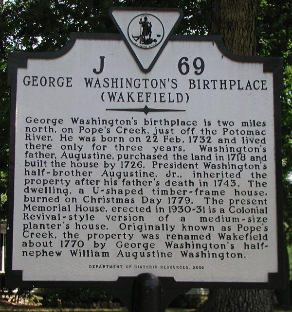
Last weekend we went to the George Washington Birthplace National Monument, in Westmoreland County, Virginia.

Interestingly, it is a re-created place, not unlike Colonial Williamsburg, and both places share John D. Rockefeller Jr. as a donor.  Rockefeller gave money to the Birthplace a few years before he was enticed to fund the preservation and re-creation of Virginia's original state capital.

It was interesting that the bookshop had a couple of titles that challenged the mythology around George Washington, and the exhibit, while very simple, started off with a section on "myth vs. fact" about George Washington.

The books, Here, George Washington Was Born: Memory, Material Culture, and the Public History of a National Monument and Inventing George Washington: America's Founder, in Myth and Memory, discuss the role of George Washington as an element of nation building and the national "story" and mythology around the founding of the United States of America, and the promotion of patriotism.

Last year, visiting Gettysburg, I was spurred to read a bunch of books about the Civil War, having been first primed a few years before by the Valentine Richmond History Center in Richmond, Virginia, and their exhibit on the historical themes of the city, which pointed out that at the outset of the Civil War, Richmonders--remember that their city was the capital of the Confederacy--voted against entering into war with the Union.

Modern historiography of the Confederacy makes hash of the "Lost Cause" myth.   Even I remember reading one of the chapters of Barrington Moore's Social Origins of Dictatorship and Democracy: Lord and Peasant in the Making of the Modern World in my sophomore year in college, and how "the Civil War was necessary to make over the US as a modern industrial economy."

[Added -- But even then I don't think the book made clear how central was to the US economy, not just for plantation agriculture in the South, but in international trade, the country's balance of payments, and as a big business for NYC-based financiers.]

Petersburg National Battlefield panel, Tourism-Historic Narrative Kiosk, Downtown Petersburg, VA
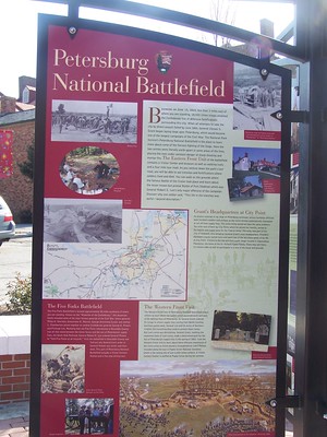
But that interpretation still hasn't percolated down much within the South more generally.  One example is the City of Petersburg, Virginia and its presentation of various Civil War sites under the control of the city [through its department of museums].  They pretty much take a pro-Confederate position.

Interpretation panel at the Petersburg, Virginia Visitor Center.

Confederate flag.  Given that a nation's flag is very much a symbol, the ongoing controversy over display of the Confederate flag is another example of the clash between reflexive "patriotism" and an unwillingness to consider all relevant elements of said symbol vs. considered reflection.

How can the flag of the Confederate States of America not be seen as a relic of racism and slavery?

More recently, the Danville Museum of Fine Arts and History has gotten caught up in this controversy.  Danville was the last "capital" of the Confederacy, and the Confederate flag flies on the Museum's grounds.

The Museum's strategic plan calls for presentation of an inclusive history and so the display of the flag is seen as incongruent with their goals and objectives and they requested from the city permission to take it down.  That has touched off great controversy and the local newspaper has a great number of articles about it (e.g., "Museum marches on with upcoming sesquicentennial commemoration," Danville Register-Bee ).

From the article:
The newly adopted strategic plan includes a vision “to be the Dan River Region’s leader for integrated awareness of history, culture and community,” according to a Sept. 30 letter from Board of Directors President Jane Murray to museum members. ...

Burton, in a Sept. 30 letter to the city, asked Danville City Council to remove the flag from outside the building to inside for an upcoming exhibit of the history of Confederate flags. The museum’s board of directors had voted Sept. 25 to make the request as part of its new three-year strategic plan.

The request caused an uproar among Confederate heritage organizations and other supporters of keeping the flag on display outside the museum. The move re-ignited a debate between flag supporters and those who see the flag as a racist reminder of past enslavement of African-Americans.

During an interview Friday, Burton said the Confederate flag exhibit that will be part of the sesquicentennial will go on as planned. People have “politicized the flag,” she said, but the museum’s board is merely trying to be inclusive and welcoming to everyone.
The comment threads are particularly interesting and there have been a number of pro- and con- letters to the editor as well (e.g., "Confederate flag must come down").

Right:  Georgia II by Leo Twiggs.

By contrast, there is an exhibit of paintings by an African-American artist at the Greenville (South Carolina) County Museum of Art ("SC artist sees heritage, hate in Confederate battle flags," Greenville News).

From the article:
Some see heritage. Some see hate.  When artist Leo Twiggs looks at the Confederate battle flag, he sees both of those things — but also a vision for a more harmonious future. 
Twiggs' 11 large depictions of the flag at the Greenville County Art Museum are at once beautiful and tattered, reflecting a shared Southern history of pride and pain. 
"In our state, I think the flag is something that many black people would like to forget and many white people would love to remember," Twiggs said. ... 
Through the repeated image of a torn and tattered flag, Twiggs addresses subtle issues about the shared Southern history of African Americans and whites, and the continued complexity of race relations.
History curriculum not patriotic:  Colorado. While interrogational historical interpretation is accepted in the academic world, it is still controversial in the K-12 educational arena, as witnessed by the recent proposal by a local school board in Colorado to make over the district's AP history curriculum because they didn't believe it is "patriotic" ("Changes in AP history trigger a culture clash in Colorado." Washington Post ).

The Board backed down after widespread protest led by students.  Image from the AP story "Colorado students walk out to protest censorship,"

Of course, the dichotomy between patriotism and "revisionism" or a broader interpretational framework for history and "social studies" is a major thread in national discourse

Personal history.  Speaking of rocking my world, and personal historiography, because of my tragic childhood, I don't have a lot of details about my own ethnicity, although I have some clues, stuff I remembered, which Suzanne decided to follow up.  So while I thought half my heritage was German/Russian, it turns out that I am Polish-Russian/Belorussian on my father's side of the family.

And looking at old records of the family, while I thought always that Hamtramack, Michigan, a Polish enclave surrounded by Detroit, was 100% Catholic, the reality is that the area also attracted, at least for a time, Polish Jewish immigrants also.

Some of my relatives likely lived for a time in or near the "Poletown" neighborhood in Detroit that was eradicated in the 1980s for a GM manufacturing plant.

On that note, the Polin Museum of the History of Polish Jews has opened today in Warsaw  ("A new Warsaw museum devoted to Jewish-Polish history," Financial Times). The museum's core galleries address the place of Jews in Poland's history, focusing on integration but acknowledging anti-Semitism, recovering memory that was eradicated finally by the Holocaust.

Crowdsourcing museum curation/the public in public history. The Wall Street Journal has a piece on crowdsourcing art exhibits, "Everybody's an Art Curator," which can be controversial when familiarity can trump artistic evaluation and merit.

On the other hand some museums have experienced a significant uptick in visitation, membership, and funding when they increase public engagement through such methods.

In terms of community history, I have had problems with the "everyone's a historian" focus of some of these kinds of initiatives.

 I do think that historians need to step in when it is warranted and provide greater context, and acknowledge developments in history at multiple scales (community, metropolitan area, region, state, nation, globe) so that important events aren't lost at the expense of the familiar and popular. See the past blog entry "Thinking about local history."

Labels: , , , , , , , , , ,